
Badwater
Encyclopedia
Badwater Basin is an endorheic basin in Death Valley National Park
, Death Valley
, Inyo County, California
, noted as the lowest point in North America
, with an elevation
of 282 ft (86 m) below sea level
. Mount Whitney
, the highest point in the contiguous 48 states, is only 84.6 miles (136.2 km) to the WNW.
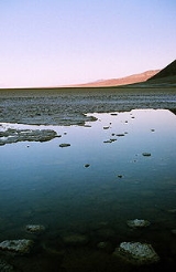
The site itself consists of a small spring
-fed pool of "bad water" next to the road in a sink
; the accumulated salt
s of the surrounding basin make it undrinkable, thus giving it the name. The pool does have animal and plant life, including pickleweed, aquatic insects, and the Badwater snail
.
Adjacent to the pool, where water is not always present at the surface, repeated freeze–thaw and evaporation cycles gradually push the thin salt crust into hexagonal honeycomb shapes.
The pool itself is not actually the lowest point of the basin: the lowest point (which is only slightly lower) is several miles to the west and varies in position. However, the salt flats are hazardous to traverse (in many cases being only a thin white crust over mud), and so the sign is at the pool. The basin was considered the lowest elevation in the Western Hemisphere
until the discovery of Laguna del Carbón
in Argentina
at -105 m.
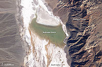 At Badwater, significant rainstorms flood the valley bottom periodically, covering the salt pan
with a thin sheet of standing water. Each newly-formed lake does not last long though, because the 1.9 in (4.8 cm) of average rainfall is overwhelmed by a 150 in (381 cm) annual evaporation
rate. This, the United States' greatest evaporation potential, means that even a 12-foot-deep, 30-mile-long lake would dry up in a single year. While the basin is flooded, some of the salt
is dissolved; it is redeposited as clean crystals when the water evaporates.
A popular site for tourists is the sign marking "sea level
" on the cliff above Badwater.
, when the regional climate was less dry, streams running from nearby mountains gradually filled Death Valley to a depth of almost 3 ft (0.9144 m), and together with Cotton Bail Marsh and Middle Basin, made up the 80 mi (128.7 km) long, Lake Manly
. Some of the minerals left behind by earlier Death Valley lakes dissolved in the shallow water, creating a briny solution.
The wet times did not last as the climate warmed and rainfall declined. The lake began to dry up and minerals dissolved in the lake became increasingly concentrated as water evaporated. Eventually, only a briny soup remained, forming salty pools on the lowest parts of Death Valley's floor. Salts (95% table salt - NaCl) began to crystallize, coating the surface with a thick crust from 3 to 60 in (7.6 to 152.4 cm).
Death Valley National Park
Death Valley National Park is a national park in the U.S. states of California and Nevada located east of the Sierra Nevada in the arid Great Basin of the United States. The park protects the northwest corner of the Mojave Desert and contains a diverse desert environment of salt-flats, sand dunes,...
, Death Valley
Death Valley
Death Valley is a desert valley located in Eastern California. Situated within the Mojave Desert, it features the lowest, driest, and hottest locations in North America. Badwater, a basin located in Death Valley, is the specific location of the lowest elevation in North America at 282 feet below...
, Inyo County, California
Inyo County, California
-National protected areas:* Death Valley National Park * Inyo National Forest * Manzanar National Historic Site-Major highways:* U.S. Route 6* U.S. Route 395* State Route 127* State Route 136* State Route 168* State Route 178...
, noted as the lowest point in North America
North America
North America is a continent wholly within the Northern Hemisphere and almost wholly within the Western Hemisphere. It is also considered a northern subcontinent of the Americas...
, with an elevation
Elevation
The elevation of a geographic location is its height above a fixed reference point, most commonly a reference geoid, a mathematical model of the Earth's sea level as an equipotential gravitational surface ....
of 282 ft (86 m) below sea level
Sea level
Mean sea level is a measure of the average height of the ocean's surface ; used as a standard in reckoning land elevation...
. Mount Whitney
Mount Whitney
Mount Whitney is the highest summit in the contiguous United States with an elevation of . It is on the boundary between California's Inyo and Tulare counties, west-northwest of the lowest point in North America at Badwater in Death Valley National Park...
, the highest point in the contiguous 48 states, is only 84.6 miles (136.2 km) to the WNW.
The site itself consists of a small spring
Spring (hydrosphere)
A spring—also known as a rising or resurgence—is a component of the hydrosphere. Specifically, it is any natural situation where water flows to the surface of the earth from underground...
-fed pool of "bad water" next to the road in a sink
Sink (geography)
A geographic sink is a depression within an endorheic basin where water collects with no visible outlet. Instead of discharging, the collected water is lost due to evaporation and/or penetration...
; the accumulated salt
Salt
In chemistry, salts are ionic compounds that result from the neutralization reaction of an acid and a base. They are composed of cations and anions so that the product is electrically neutral...
s of the surrounding basin make it undrinkable, thus giving it the name. The pool does have animal and plant life, including pickleweed, aquatic insects, and the Badwater snail
Badwater snail
The Badwater snail, scientific name Assiminea infirma, is a species of minute, salt marsh snail; of the Badwater Basin in Death Valley, California, United States....
.
Adjacent to the pool, where water is not always present at the surface, repeated freeze–thaw and evaporation cycles gradually push the thin salt crust into hexagonal honeycomb shapes.
The pool itself is not actually the lowest point of the basin: the lowest point (which is only slightly lower) is several miles to the west and varies in position. However, the salt flats are hazardous to traverse (in many cases being only a thin white crust over mud), and so the sign is at the pool. The basin was considered the lowest elevation in the Western Hemisphere
Extremes on Earth
This article describes extreme locations on Earth. Entries listed in bold are Earth-wide extremes.-Extreme elevations and temperatures per continent:This article describes extreme locations on Earth. Entries listed in bold are Earth-wide extremes....
until the discovery of Laguna del Carbón
Laguna del Carbón
Laguna del Carbón is an endorheic salt lake in the Gran Bajo de San Julián of Santa Cruz Province, Argentina, 54 km from Puerto San Julián...
in Argentina
Argentina
Argentina , officially the Argentine Republic , is the second largest country in South America by land area, after Brazil. It is constituted as a federation of 23 provinces and an autonomous city, Buenos Aires...
at -105 m.
Geography
Dry lake
Dry lakes are ephemeral lakebeds, or a remnant of an endorheic lake. Such flats consist of fine-grained sediments infused with alkali salts. Dry lakes are also referred to as alkali flats, sabkhas, playas or mud flats...
with a thin sheet of standing water. Each newly-formed lake does not last long though, because the 1.9 in (4.8 cm) of average rainfall is overwhelmed by a 150 in (381 cm) annual evaporation
Evaporation
Evaporation is a type of vaporization of a liquid that occurs only on the surface of a liquid. The other type of vaporization is boiling, which, instead, occurs on the entire mass of the liquid....
rate. This, the United States' greatest evaporation potential, means that even a 12-foot-deep, 30-mile-long lake would dry up in a single year. While the basin is flooded, some of the salt
Salt
In chemistry, salts are ionic compounds that result from the neutralization reaction of an acid and a base. They are composed of cations and anions so that the product is electrically neutral...
is dissolved; it is redeposited as clean crystals when the water evaporates.
A popular site for tourists is the sign marking "sea level
Sea level
Mean sea level is a measure of the average height of the ocean's surface ; used as a standard in reckoning land elevation...
" on the cliff above Badwater.
History
During the HoloceneHolocene
The Holocene is a geological epoch which began at the end of the Pleistocene and continues to the present. The Holocene is part of the Quaternary period. Its name comes from the Greek words and , meaning "entirely recent"...
, when the regional climate was less dry, streams running from nearby mountains gradually filled Death Valley to a depth of almost 3 ft (0.9144 m), and together with Cotton Bail Marsh and Middle Basin, made up the 80 mi (128.7 km) long, Lake Manly
Lake Manly
Lake Manly is a pluvial, former freshwater, endorheic, rift lake that filled the Death Valley basin of Inyo County, California through the Holocene before the area's climate changed to desert. Following its isolation from the Colorado River system, Lake Manly receded by evaporation with Badwater...
. Some of the minerals left behind by earlier Death Valley lakes dissolved in the shallow water, creating a briny solution.
The wet times did not last as the climate warmed and rainfall declined. The lake began to dry up and minerals dissolved in the lake became increasingly concentrated as water evaporated. Eventually, only a briny soup remained, forming salty pools on the lowest parts of Death Valley's floor. Salts (95% table salt - NaCl) began to crystallize, coating the surface with a thick crust from 3 to 60 in (7.6 to 152.4 cm).
Further reading
- John McKinney: California's Desert Parks: A Day Hiker's Guide. Wilderness Press 2006, ISBN 0899973892, S. 54-55
- Don J. Easterbrook (Hrsg): Quaternary Geology of the United States. Geological Society of America 2003, ISBN 9459205046, S.63-64
External links
- Badwater Basin in the Encyclopædia BritannicaEncyclopædia BritannicaThe Encyclopædia Britannica , published by Encyclopædia Britannica, Inc., is a general knowledge English-language encyclopaedia that is available in print, as a DVD, and on the Internet. It is written and continuously updated by about 100 full-time editors and more than 4,000 expert...