

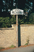
Askam and Ireleth
Encyclopedia
Middle Ages
The Middle Ages is a periodization of European history from the 5th century to the 15th century. The Middle Ages follows the fall of the Western Roman Empire in 476 and precedes the Early Modern Era. It is the middle period of a three-period division of Western history: Classic, Medieval and Modern...
, the entire area was controlled by the Cistercian monks of Furness Abbey
Furness Abbey
Furness Abbey, or St. Mary of Furness is a former monastery situated on the outskirts of the English town of Barrow-in-Furness, Cumbria. The abbey dates back to 1123 and was once the second wealthiest and most powerful Cistercian monastery in the country, behind only Fountains Abbey in North...
. During this time, Ireleth was little more than one of many farming communities in Furness. The iron ore developments of Askam largely bypassed Ireleth, and the village developed slowly, housing farmers and workers from local towns. The religious history of the village is recorded as starting around the year 1608, when an endowment was created to fund a village school. Giles Brownrigg, named variously as a local landowner or a tailor who had left the area to make his fortune in London, gave money to establish a school house and a salary for a schoolmaster. This building existed on what is today Sun Street; the only remains today are a font and a plaque, kept in the modern day school building, inscribed:
Ireleth featured in the Imperial Gazetteer of England and Wales
Imperial Gazetteer of England and Wales
The Imperial Gazetteer of England and Wales is a substantial topographical dictionary first published between 1870 and 1872, edited by the Reverend John Marius Wilson. It contains a detailed description of England and Wales...
. In this, it is said-
Ireleth did not have a parish church at this point, falling into the 'Above Town' area, together with the hamlets of Marton and Lindal, of the parish of Dalton-in-Furness
Dalton-in-Furness
Dalton-in-Furness is a small town of 8,394 people, north east of Barrow-in-Furness, in Cumbria, England.-History:Dalton is mentioned in the Domesday Book, written as "Daltune" as one of the townships forming the Manor of Hougun held by Earl Tostig. Historically, it was the capital of Furness...
. Lacking a place of worship, it was decided the newly-built school could also be put to use as a chapel. Fishwick's 'Lancashire & Cheshire Church Surveys, 1649–1655' of 1849 cites this record from a church survey taken in 1650:
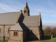
In 1860, Ireleth, along with the newly founded Askam, petitioned for the creation of its own parish following the rapid increase in population. Construction of a parish church began, with the money to build St. Peter's coming from the new-found profits of iron ore mining, giving rise to the name the 'Iron Church'. It was dedicated for use on St. Peter's Day, 29 June 1865, but approval for a new ecclesiastical parish of 'Ireleth-with-Askam' did not come until almost ten years later in 1874.
Askam
Dalton-in-Furness
Dalton-in-Furness is a small town of 8,394 people, north east of Barrow-in-Furness, in Cumbria, England.-History:Dalton is mentioned in the Domesday Book, written as "Daltune" as one of the townships forming the Manor of Hougun held by Earl Tostig. Historically, it was the capital of Furness...
), Roanhead and Dalton. They were all owned by the Kennedy Brothers Ltd. firm of Ulverston
Ulverston
Ulverston is a market town and civil parish in the South Lakeland district of Cumbria in north-west England. Historically part of Lancashire, the town is located in the Furness area, close to the Lake District, and just north of Morecambe Bay....
or the Millom and Askam Iron Company. The latter built four blast furnace
Blast furnace
A blast furnace is a type of metallurgical furnace used for smelting to produce industrial metals, generally iron.In a blast furnace, fuel and ore and flux are continuously supplied through the top of the furnace, while air is blown into the bottom of the chamber, so that the chemical reactions...
s in the village to smelt the iron ore being brought from mines all over the peninsula by rail. The village continued to grow with terraced houses and allotments erected for the flood of immigrant labour needed to work the mines. They came from all parts of the British Isles
British Isles
The British Isles are a group of islands off the northwest coast of continental Europe that include the islands of Great Britain and Ireland and over six thousand smaller isles. There are two sovereign states located on the islands: the United Kingdom of Great Britain and Northern Ireland and...
, with a large proportion coming from existing mining areas in Cornwall
Cornwall
Cornwall is a unitary authority and ceremonial county of England, within the United Kingdom. It is bordered to the north and west by the Celtic Sea, to the south by the English Channel, and to the east by the county of Devon, over the River Tamar. Cornwall has a population of , and covers an area of...
and Ireland. The Cornish in particular tended to bring their families and settle, while the Irish often moved on to wherever there was work. Others came from areas where Askam's mine owners had other concerns, such as Scotland and Wales
Wales
Wales is a country that is part of the United Kingdom and the island of Great Britain, bordered by England to its east and the Atlantic Ocean and Irish Sea to its west. It has a population of three million, and a total area of 20,779 km²...
.
Millom
Millom is a town and civil parish on the estuary of the River Duddon in the southwest of Cumbria, England. The name is Cumbrian dialect for "At the mills". The town is accessible both by rail and an A class road...
. Also, numerous streets are named after the industry and its owners. For example, 'Steel Street' is so named because of the steel industry; 'Sharp Street' is named after Joseph Sharp, one of the earliest people involved in Askam's steel industry; and 'Crossley Street' after William Crossley, an early investor in the Askam steel industry. The large numbers of slag banks left by the steel industry around the village are now important sites for wildlife. By 1918, the iron ore had run out and most of the industrial buildings were demolished in 1933. Since then, Askam has grown with commuter homes, exploiting the views over the Duddon Estuary to the Lake District
Lake District
The Lake District, also commonly known as The Lakes or Lakeland, is a mountainous region in North West England. A popular holiday destination, it is famous not only for its lakes and its mountains but also for its associations with the early 19th century poetry and writings of William Wordsworth...
.
Etymology
Both are part of the 'Furness' peninsula, and as such the suffix -in-Furness can be added, in common with other settlements such as Barrow-in-Furness
Barrow-in-Furness
Barrow-in-Furness is an industrial town and seaport which forms about half the territory of the wider Borough of Barrow-in-Furness in the county of Cumbria, England. It lies north of Liverpool, northwest of Manchester and southwest from the county town of Carlisle...
and Dalton-in-Furness
Dalton-in-Furness
Dalton-in-Furness is a small town of 8,394 people, north east of Barrow-in-Furness, in Cumbria, England.-History:Dalton is mentioned in the Domesday Book, written as "Daltune" as one of the townships forming the Manor of Hougun held by Earl Tostig. Historically, it was the capital of Furness...
. Askam, when referred to on its own, often uses this but it is rare for Ireleth to be called Ireleth-in-Furness. A possible explanation for this is that the majority of in-Furness place names were inventions of the railway that either created the settlements or caused their rapid expansion; Ireleth, untouched by the railway, was not affected by this convention.
However, Ireleth is often confused in archival records with 'Kirkby Ireleth', the former name for the community (two miles to the north) now known as Kirkby-in-Furness
Kirkby-in-Furness
Kirkby-in-Furness is a village in the Furness area of Cumbria, England. It is about 5 km south of Broughton in Furness and 8 km northwest of Ulverston. It is one of the largest villages on the peninsula's north-western coast, looking out over the Duddon estuary and the mountains of the...
. These communities are differentiated in the Imperial Gazetteer of England and Wales.
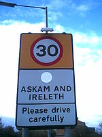
While the strip development has effectively created one larger community in the past fifty years, residents of both villages still retain a strong sense of being either from Askam or Ireleth. Road signs read 'Askam and Ireleth' on entering the villages by road, but an older 'A595 – Ireleth' sign still stands on the former boundary between the two.
In administration terms, the civil parish of which they are both part uses the name Askam with Ireleth, as does the local Women's Institute (WI) which had previously been called Ireleth WI.
Geology
The geological make-up of the area is extremely important; indeed, without it, Askam as a place would not exist. The upper slopes of the hill near Ireleth are home to dark blue slate and is found on the roofs of several local dwellings. Haematite, the bright red iron ore, was discovered in an exceptionally large deposit—the second largest in the country—south of the current villages in the 1840s. Askam sprung up on the Ireleth marshes as a home for the miners attacking the new deposit. The other mineral found in large quantities, conveniently with a commercial use, is shaleShale
Shale is a fine-grained, clastic sedimentary rock composed of mud that is a mix of flakes of clay minerals and tiny fragments of other minerals, especially quartz and calcite. The ratio of clay to other minerals is variable. Shale is characterized by breaks along thin laminae or parallel layering...
. This is fired with water to make red brick, and the brickworks, which is still operational today, was built in 1845 to exploit this.
Wildlife
Much wildlife is found on the Duddon Estuary, perhaps most notably 20% of the national Natterjack toadNatterjack Toad
The Natterjack Toad is a toad native to sandy and heathland areas of Europe. Adults are 60–70 mm in length and are distinguished from Common Toads by a yellow line down the middle of the back...
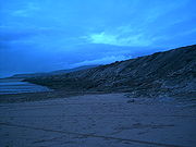
population, who are attracted to the shallow breeding pools. The slagbanks around Askam are also very important as nesting sites for the rare sandwich terns that live in the area. The beach is designated an Site of Special Scientific Interest (SSSI) because of the range of flora and fauna present on the sands.
Wind energy
E.ON
E.ON
E.ON AG, marketed with an interpunct as E•ON, is the holding company of the world's largest investor-owned energy service provider based in Düsseldorf, Germany. The name comes from the Greek word aeon which means eternity....
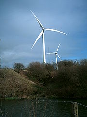
, the current operator, claims that the wind farm generated enough renewable electricity in 2005 to supply nearly 2,500 homes and avoided the emission of over 4,000 tonnes of carbon dioxide. The wind farm, which features seven turbines measuring 40 metres (131 ft) to the top of the tower, is not permanently manned. Instead it is controlled and monitored from Rheidol Hydroelectric Power Station
Rheidol Power Station
Rheidol power station is a 56 MW hydroelectric scheme near Aberystwyth, Wales. It was built between 1957 and 1962 and was officially opened on 3 July 1964. It has been operated by Statkraft since 2008 after it was transferred from E.ON UK as part of a swap for shares....
, near Aberystwyth
Aberystwyth
Aberystwyth is a historic market town, administrative centre and holiday resort within Ceredigion, Wales. Often colloquially known as Aber, it is located at the confluence of the rivers Ystwyth and Rheidol....
, Mid Wales.
Local opposition to the windfarm
The Marton, Askam and Ireleth Windfarm Action Group (MAIWAG) was formed by local residents of the three villages upset by what they saw as the inconsiderate construction of the windfarm by then developers Wind Prospect. The group claimed the reality of the windfarm at Far Old Park farm bore little resemblance to the proposed scheme they were first told about. Their main concerns related to the size and environmental impact of the development as well as noise it produced. It was discovered that six of the sevem turbines were not constructed in line with the developer's original application and as such did not have planning permission. Barrow Borough Council signed an agreement with the developer, imposing a range of planning conditions on the turbines already built. As complaints by local residents continued to be made about the noise the council resolved to take action against the windfarm. Later, borough councillors decided to drop this planned enforcement action in December 2002. Disappointed by this decision, six members of the group went ahead with a private prosecution against the owners and operators of the windfarm on the grounds it was a 'noise nuisance.' but their case was unsuccessful.The group was one of the first such organisations in the UK dedicated to fighting windfarm development. Members of the group later toured the country to share their experiences and aid other countryside defence groups in their fight against excessive windfarm development.
Location and transport
A595 road
The A595 is a primary route in Cumbria, in northern England that starts in Carlisle, passes through Whitehaven, and goes close to Workington, Cockermouth and Wigton. It passes Sellafield and Ravenglass before ending at the Dalton-in-Furness by-pass, in southern Cumbria, where it joins the A590...
is the main coastal route, designated a primary route, connecting Barrow
Barrow-in-Furness
Barrow-in-Furness is an industrial town and seaport which forms about half the territory of the wider Borough of Barrow-in-Furness in the county of Cumbria, England. It lies north of Liverpool, northwest of Manchester and southwest from the county town of Carlisle...
and South Cumbria to Copeland
Copeland, Cumbria
Copeland is a local government district and borough in western Cumbria, England. Its council is based in Whitehaven. It was formed on 1 April 1974 by the merger of the borough of Whitehaven, Ennerdale Rural District and Millom Rural District....
, Workington
Workington
Workington is a town, civil parish and port on the west coast of Cumbria, England, at the mouth of the River Derwent. Lying within the Borough of Allerdale, Workington is southwest of Carlisle, west of Cockermouth, and southwest of Maryport...
, and Whitehaven
Whitehaven
Whitehaven is a small town and port on the coast of Cumbria, England, which lies equidistant between the county's two largest settlements, Carlisle and Barrow-in-Furness, and is served by the Cumbrian Coast Line and the A595 road...
. Its southern end is two miles (3 km) south of Askam at the junction with the A590
A590 road
The A590 is a trunk road in southern Cumbria, in the north-west of England. It runs north-east to south-west from M6 junction 36, through the towns of Ulverston and Barrow-in-Furness to terminate at Vickerstown on Walney Island. The road is a mixture of dual carriageway and single carriageway,...
Dalton-in-Furness bypass. The area is served by Stagecoach Cumbria service, 7A and X7 as well as various school services. There are plans to construct a crossing over the Duddon between Askam and Millom
Millom
Millom is a town and civil parish on the estuary of the River Duddon in the southwest of Cumbria, England. The name is Cumbrian dialect for "At the mills". The town is accessible both by rail and an A class road...
to reduce the long journey times between Furness
Furness
Furness is a peninsula in south Cumbria, England. At its widest extent, it is considered to cover the whole of North Lonsdale, that part of the Lonsdale hundred that is an exclave of the historic county of Lancashire, lying to the north of Morecambe Bay....
and Copeland
Copeland, Cumbria
Copeland is a local government district and borough in western Cumbria, England. Its council is based in Whitehaven. It was formed on 1 April 1974 by the merger of the borough of Whitehaven, Ennerdale Rural District and Millom Rural District....
, due to the circuitous route of the A595 around the estuary. A scheme to build such a 'Duddon Crossing' remains at the planning stage, but is nominated as a future project in county transport planning.
Askam is located on the 150 miles (241.4 km) Cumbrian Coastal Walk, which winds around the edge of the county. The railway line passing through the two villages virtually bisecting them, with a bridge and a level crossing
Level crossing
A level crossing occurs where a railway line is intersected by a road or path onone level, without recourse to a bridge or tunnel. It is a type of at-grade intersection. The term also applies when a light rail line with separate right-of-way or reserved track crosses a road in the same fashion...
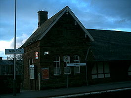
by the station allowing people to cross the line. There is a stop called Askam Railway Station
Askam railway station
Askam Railway Station serves the villages of Askam-in-Furness and Ireleth in Cumbria, England. The railway station is a stop on the scenic Cumbrian Coast Line. Some through trains to the Furness Line stop here. It is operated by Northern Rail who provide all passenger train services...
. This line links to the Sellafield nuclear power plant
Sellafield
Sellafield is a nuclear reprocessing site, close to the village of Seascale on the coast of the Irish Sea in Cumbria, England. The site is served by Sellafield railway station. Sellafield is an off-shoot from the original nuclear reactor site at Windscale which is currently undergoing...
in Seascale
Seascale
Seascale is a village and civil parish on the Irish Sea coast of Cumbria in north-west England.-History:The place-name indicates that it was inhabited by Norse settlers, probably before 1000 AD. It is derived from skali, meaning in Norse a wooden hut or shelter...
, West Cumbria
Cumbria
Cumbria , is a non-metropolitan county in North West England. The county and Cumbria County Council, its local authority, came into existence in 1974 after the passage of the Local Government Act 1972. Cumbria's largest settlement and county town is Carlisle. It consists of six districts, and in...
.
Politics and demographics
As a civil parishCivil parish
In England, a civil parish is a territorial designation and, where they are found, the lowest tier of local government below districts and counties...
, the villages have a parish council which usually meets monthly, normally the third Tuesday of each month.
All eight councillors will be up for election at the forthcoming English local government elections on 3 May 2007. The villages also fall into the Dalton
Dalton-in-Furness
Dalton-in-Furness is a small town of 8,394 people, north east of Barrow-in-Furness, in Cumbria, England.-History:Dalton is mentioned in the Domesday Book, written as "Daltune" as one of the townships forming the Manor of Hougun held by Earl Tostig. Historically, it was the capital of Furness...
North ward of the borough, with voters electing three councillors to represent them on the council. The ward also elects one councillor to represent it on Cumbria
Cumbria
Cumbria , is a non-metropolitan county in North West England. The county and Cumbria County Council, its local authority, came into existence in 1974 after the passage of the Local Government Act 1972. Cumbria's largest settlement and county town is Carlisle. It consists of six districts, and in...
County Council. It is part of the Barrow and Furness parliamentary constituency
Barrow and Furness (UK Parliament constituency)
Barrow and Furness is a parliamentary constituency in Cumbria, represented in the House of Commons of the Parliament of the United Kingdom...
, represented by Labour
Labour Party (UK)
The Labour Party is a centre-left democratic socialist party in the United Kingdom. It surpassed the Liberal Party in general elections during the early 1920s, forming minority governments under Ramsay MacDonald in 1924 and 1929-1931. The party was in a wartime coalition from 1940 to 1945, after...
MP
Member of Parliament
A Member of Parliament is a representative of the voters to a :parliament. In many countries with bicameral parliaments, the term applies specifically to members of the lower house, as upper houses often have a different title, such as senate, and thus also have different titles for its members,...
John Woodcock
John Woodcock (UK politician)
John Zak Woodcock is a British Labour Co-operative politician. He was elected as the Member of Parliament for Barrow and Furness in 2010.-Early and personal life:...
.
According to the most recent census, in 2001, the population of the (civil) parish is as follows:
| Population | ||||||
|---|---|---|---|---|---|---|
| Total | ||||||
| 3632 | ||||||
| of which: | ||||||
| Male | 1807 | |||||
| Female | 1825 | |||||
| by age: | ||||||
| 0–4 | 5–15 | 16–24 | 25–44 | 45–64 | 65–74 | 75+ |
| 224 | 616 | 317 | 1047 | 915 | 296 | 217 |
Sport
Rugby league
Rugby league football, usually called rugby league, is a full contact sport played by two teams of thirteen players on a rectangular grass field. One of the two codes of rugby football, it originated in England in 1895 by a split from Rugby Football Union over paying players...
Football Club. Formed in 1879, the amateur club is a member of British Amateur Rugby League Association
British Amateur Rugby League Association
The British Amateur Rugby League Association is the governing body for social and recreational rugby league in the United Kingdom...
and in 2007-2008 were elected to the National Conference League
National Conference League
The National Conference League is the top league in the pyramid of amateur rugby leagues run by the British Amateur Rugby League Association...
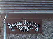
Division 2, but withdrew before the start of the season. There is also Askam United Football Club who play in the West Lancashire Football League
West Lancashire Football League
The West Lancashire Football League is a football competition based in northern England, consisting of five divisions - three for first teams , and two for reserve teams...
Division Two and Duddon SC, a cricket
Cricket
Cricket is a bat-and-ball game played between two teams of 11 players on an oval-shaped field, at the centre of which is a rectangular 22-yard long pitch. One team bats, trying to score as many runs as possible while the other team bowls and fields, trying to dismiss the batsmen and thus limit the...
team based at the old K Shoes factory social club, now called Duddon Sports and Social Club. There is also a newly formed junior football team and due to playing on the Sports Club pitches, has taking the name of Duddon Sports Junior Football Club.
A 10-hole links
Links (golf)
A links is the oldest style of golf course, first developed in Scotland. The word "links" comes from the Scots language and refers to an area of coastal sand dunes and sometimes to open parkland. It also retains this more general meaning in the Scottish English dialect...
golf course, belonging to the Dunnerholme Golf Club, lies to the north of Askam. The course has one particularly interesting feature, namely a green atop Dunnerholme Rock, a large uneroded limestone
Limestone
Limestone is a sedimentary rock composed largely of the minerals calcite and aragonite, which are different crystal forms of calcium carbonate . Many limestones are composed from skeletal fragments of marine organisms such as coral or foraminifera....
rock which stands out from the surrounding flat course and sands. The golf club has been in existence since 1905.
Village halls
There are four village halls, the Temperance Hall in Ireleth, the Community CentreCommunity centre
Community centres or community centers or jumping recreation centers are public locations where members of a community tend to gather for group activities, social support, public information, and other purposes. They may sometimes be open for the whole community or for a specialised group within...
(formerly part of Askam School)which has recently been refurbished (2010), the Band Hall in Sandy Lane, the home of the local Brass Band and venue for dances in the village, and the Rankin Hall in Askam.
The Temperance Hall, on Saves Lane, is a reminder of the Furness
Furness
Furness is a peninsula in south Cumbria, England. At its widest extent, it is considered to cover the whole of North Lonsdale, that part of the Lonsdale hundred that is an exclave of the historic county of Lancashire, lying to the north of Morecambe Bay....
area's strong history of non-conformism. Built by the Society of Friends (the Quakers) in 1872, it was marked as a place of worship on Ordnance Survey maps of the late 19th century, and was used by a Methodist
Methodism
Methodism is a movement of Protestant Christianity represented by a number of denominations and organizations, claiming a total of approximately seventy million adherents worldwide. The movement traces its roots to John Wesley's evangelistic revival movement within Anglicanism. His younger brother...
offshoot group called the Bible Christians. It later fell out of use as a religious centre, being marked on maps in 1913 as simply a hall. The Temperance Hall was closed before being renovated in the 1990s, and is now used as a community centre and the location of parish council alternate months with the Rankin Hall, which is also the meeting place for the local Women's Institute.
Churches
As already mentioned, there is St. Peter's Church overlooking the two villages atop Ireleth Hill, which is the oldest of the churches in the villages, and holds the only churchyard in the villages and adjoins the local cemetery; and the Temperance Hall that was once used as a church. There are three other places of worship within the village.In 1907, at a cost of £350, The Christian Meeting House was built on Crossley Street in Askam, as a Church of Christ
Church of Christ
Churches of Christ are autonomous Christian congregations associated with one another through common beliefs and practices. They seek to base doctrine and practice on the Bible alone, and seek to be New Testament congregations as originally established by the authority of Christ. Historically,...
Church. This became, in 1956, St. Anthony
Anthony the Great
Anthony the Great or Antony the Great , , also known as Saint Anthony, Anthony the Abbot, Anthony of Egypt, Anthony of the Desert, Anthony the Anchorite, Abba Antonius , and Father of All Monks, was a Christian saint from Egypt, a prominent leader among the Desert Fathers...
's Catholic
Catholic
The word catholic comes from the Greek phrase , meaning "on the whole," "according to the whole" or "in general", and is a combination of the Greek words meaning "about" and meaning "whole"...
Church, and is still used in that capacity today. Sadly it is due to close by the end of 2009. On Duddon Road, in Askam, there is also a Methodist Church, called Duddon Road Church. This is a shared building with the Church of England and is the headquarters of the local scouts, cubs, beavers, rainbows and brownies.
There were once two other churches in the village, but they are no longer in use as Churches. Zion, on Beach Street, Askam, was a Primitive Methodist church that was founded in 1870. It closed in 1985. There was also a United Methodist Church in Askam, and though the building still stands on Duke Street, it is now used as a social club. The Church was opened in 1878, on land that was donated by the Furness Iron and Steel Company. and became the Rankin Hall (see above) The Gospel hall on Duke Street closed some five years ago.
Other buildings
There is a lifeboatLifeboat (rescue)
A rescue lifeboat is a boat rescue craft which is used to attend a vessel in distress, or its survivors, to rescue crewmen and passengers. It can be hand pulled, sail powered or powered by an engine...
station, home of the Duddon Inshore Rescue, that was established in 1970.
Askam has a fountain commemorating Queen Victoria's Jubilee
Diamond Jubilee
A Diamond Jubilee is a celebration held to mark a 60th anniversary in the case of a person or a 75th anniversary in the case of an event.- Thailand :...
. There are two schools, Ireleth St Peter's C.E.
Church of England
The Church of England is the officially established Christian church in England and the Mother Church of the worldwide Anglican Communion. The church considers itself within the tradition of Western Christianity and dates its formal establishment principally to the mission to England by St...
Primary School and Askam Village School, both of which are primary schools. There are no secondary schools in the village.
External links
- Google Maps' view of the Askam and Ireleth area.
- A Short History of Ireleth and Askam-in-Furness, by Mark Maclean. This book is available freely in PDF format, and the information has been compiled from numerous other sources, all of which are cited in the book.