
Amphoe Mueang Phang Nga
Encyclopedia
Mueang Phang Nga is the capital district (amphoe mueang) of Phang Nga Province
in southern Thailand
.
, Phanom
of Surat Thani Province
, Kapong
, Thai Mueang
and Takua Thung
. To the south is the Phang Nga bay
, with the insular district Ko Yao
.
The Ao Phang Nga National Park
covers the islands south of the district. Sa Nang Manora Forest Park
protects 0.29 km² of the Khao Toy Nang Hong Forest around the Sa Nang Manora waterfall. The Tonpariwat Wildlife Sanctuary
in the north of the district is under construction. There are also several caves within the limestone hills.
), which are further subdivided into 42 villages (muban
). Phang Nga
itself is a town (thesaban mueang) and covers the tambon Thai Chang. There are further 7 tambon administrative organizations (TAO).
Phang Nga Province
Phang Nga is one of the southern provinces of Thailand, on the shore to the Andaman Sea. Neighboring provinces are Ranong, Surat Thani and Krabi. To the south is the Phuket province, but without land boundary to Phang Nga....
in southern Thailand
Thailand
Thailand , officially the Kingdom of Thailand , formerly known as Siam , is a country located at the centre of the Indochina peninsula and Southeast Asia. It is bordered to the north by Burma and Laos, to the east by Laos and Cambodia, to the south by the Gulf of Thailand and Malaysia, and to the...
.
Geography
Neighboring districts are (from the east clockwise) Thap PutAmphoe Thap Put
Thap Phut is a district in the province Phang Nga in the south of Thailand.-History:In 1785 Burmese troops attacked Mueang Thalang. The inhabitants escaped from Thalang to the area of modern-day Thap Put. They built shelter that in southern Thai language are called Thap...
, Phanom
Amphoe Phanom
Phanom is a district in the southwest of Surat Thani Province of southern Thailand.-Geography:The district is located within the hills of the Phuket mountain range, with around 60% of the area consisting of mountains and forests. The northwestern part of the district is protected in the Khao Sok...
of Surat Thani Province
Surat Thani Province
Surat Thani is the largest of the southern provinces of Thailand, on the eastern shore of the Gulf of Thailand. Surat Thani means City of Good People, the title given to the city by King Vajiravudh ....
, Kapong
Amphoe Kapong
Kapong is a district in the province Phang Nga in the south of Thailand.-Geography:Neighboring districts are Phanom of Surat Thani Province, Mueang Phang Nga, Thai Mueang and Takua Pa....
, Thai Mueang
Amphoe Thai Mueang
Thai Mueang is a district in the province Phang Nga in the south of Thailand.-Geography:Neighboring districts are Takua Pa, Kapong, Mueang Phang Nga and Takua Thung. To the west is the Andaman Sea....
and Takua Thung
Amphoe Takua Thung
Takua Thung is a district in the province Phang Nga in the south of Thailand.-History:Mueang Takua Thung is an ancient city same as Phang Nga and Takua Pa. The old city hall was located in Ban Khai, Tambon Bang Thong, Amphoe Thai Mueang. In 1894 Burmese troops attacked Mueang Takua Pa. Thalang...
. To the south is the Phang Nga bay
Phang Nga Bay
Phang Nga Bay is a 400 km² bay in the Andaman Sea between the island of Phuket and the mainland of the Malay peninsula of southern Thailand. Since 1981, an extensive section of the bay has been protected as the Ao Phang Nga National Park...
, with the insular district Ko Yao
Amphoe Ko Yao
Ko Yao is a district in the province Phang Nga in the south of Thailand.-History:The minor district Ko Yao was established in 1903 as a subordinate of Mueang Phang Nga district...
.
The Ao Phang Nga National Park
Ao Phang Nga National Park
Ao Phang Nga national park is located in Phang Nga Province in southern Thailand.Ao Phang Nga park was created by Royal decree and announced in the Royal Gazette under proclamation number 98 section 64 of April 29, 1981,- References :* *...
covers the islands south of the district. Sa Nang Manora Forest Park
Sa Nang Manora Forest Park
Sa Nang Manora is a Forest Park in southern Thailand. It covers an area of 0.29 km² of the Khao Thoi-Nang Hong Forest, Nop Pring subdistrict, Mueang district, Phang Nga Province, about 4 km north of Phang Nga town. It was established on September 15, 1980.The park is on mostly plain terrain with...
protects 0.29 km² of the Khao Toy Nang Hong Forest around the Sa Nang Manora waterfall. The Tonpariwat Wildlife Sanctuary
Tonpariwat Wildlife Sanctuary
The Tonpariwat Wildlife Sanctuary is located in the north of Mueang Phang Nga district, Phang Nga Province, southern Thailand. It covers an area of 224 square kilometres of forested hills at the southern end of the Phuket mountain range...
in the north of the district is under construction. There are also several caves within the limestone hills.
Administration
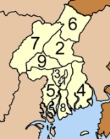
The district is subdivided into 9 subdistricts (tambonTambon
Tambon is a local government unit in Thailand. Below district and province , they form the third administrative subdivision level. As of the 2009 there are 7255 tambon, not including the 169 khwaeng of Bangkok, which are set at the same administrative level, thus every district contains 8-10 tambon...
), which are further subdivided into 42 villages (muban
Muban
Muban is the lowest administrative subdivision of Thailand. Usually translated as village, they are the subdivision of tambon. As of 2008, there are 74944 administrative villages in Thailand. As of the 1990 census, the average village consisted of 144 households or 746 persons.A muban does not...
). Phang Nga
Phang Nga
Phang Nga ) is a town in southern Thailand, capital of the Phang Nga Province. The town covers the whole tambon Thai Chang of Mueang Phang Nga district. As of 2005 it has a population of 9,559 and covers an area of 6.75 km²....
itself is a town (thesaban mueang) and covers the tambon Thai Chang. There are further 7 tambon administrative organizations (TAO).
|
 |