
Amphoe Phato
Encyclopedia
Phato is a district (Amphoe
) of Chumphon Province
, southern Thailand
.
Lang Suan, which was abolished and included into Chumphon province in 1932. In 1938 Phato was reduced to a minor district (King Amphoe). On June 19 1991 it was upgraded to a full district.
and Lamae
of Chumphon province, Tha Chana
and Chaiya of Surat Thani Province
, Kapoe
, Mueang Ranong
and La-un
of Ranong Province
.
Within the Kuan Mae Yai Mon Wildlife Sanctuary in the southwest of the district is the Heo Lom waterfall, one of the attractions of the district. The terrain is mostly mountainous with several small rivers, which make it a popular place for rafting
.
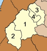
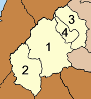
), which are further subdivided into 43 villages (muban
). The subdistrict municipality (thesaban tambon) Phato covers part of the tambon Phato, the subdistrict municipality Pak Song the whole same-named subdistrict. There are further 3 Tambon administrative organizations.
Amphoe
An amphoe is the second level administrative subdivision of Thailand. Usually translated as district, amphoe make up the provinces, and are analogous to a county seat...
) of Chumphon Province
Chumphon Province
Chumphon ) is one of the southern provinces of Thailand, at the shore of the Gulf of Thailand. Neighboring provinces are Prachuap Khiri Khan, Surat Thani and Ranong...
, southern Thailand
Thailand
Thailand , officially the Kingdom of Thailand , formerly known as Siam , is a country located at the centre of the Indochina peninsula and Southeast Asia. It is bordered to the north by Burma and Laos, to the east by Laos and Cambodia, to the south by the Gulf of Thailand and Malaysia, and to the...
.
History
Originally Patho was a district of MueangMueang
Mueang were historical semi-independent city-states or principalities in present-day Thailand, Laos, parts of northern Vietnam and the Shan State of Myanmar. Smaller Mueang were subordinate to more powerful neighboring Mueang, which in turn were subordinate to the central king, as described in...
Lang Suan, which was abolished and included into Chumphon province in 1932. In 1938 Phato was reduced to a minor district (King Amphoe). On June 19 1991 it was upgraded to a full district.
Geography
Neighboring districts are (from the east clockwise) Lang SuanAmphoe Lang Suan
-History:Lang Suan was originally a Mueang reporting directly to Bangkok. During the thesaphiban reforms at the end of the 19th century it was put under Monthon Chumphon...
and Lamae
Amphoe Lamae
Lamae is a district in the southern part of Chumphon Province, southern Thailand.-Geography:Neighboring districts are Tha Chana of Surat Thani Province, Phato and Lang Suan of Chumphon province...
of Chumphon province, Tha Chana
Amphoe Tha Chana
Tha Chana is a district in the north of Surat Thani Province of southern Thailand.-History:The district is already quite old. Originally named Prasong , it was a subordinate of Mueang Lang Suan. In 1906 it was reassigned to Mueang Chaiya, which is now Surat Thani province. The seat of the...
and Chaiya of Surat Thani Province
Surat Thani Province
Surat Thani is the largest of the southern provinces of Thailand, on the eastern shore of the Gulf of Thailand. Surat Thani means City of Good People, the title given to the city by King Vajiravudh ....
, Kapoe
Amphoe Kapoe
Kapoe is a district of Ranong Province, southern Thailand.-Geography:Neighboring districts are Mueang Ranong of Ranong Province, Phato of Chumphon Province, Chaiya, Tha Chang and Ban Ta Khun of Surat Thani Province, and Suk Samran of Ranong again...
, Mueang Ranong
Amphoe Mueang Ranong
Mueang Ranong is the capital district of Ranong Province, southern Thailand.-Geography:Neighboring districts are La-un of Ranong Province, Phato of Chumphon Province, and Kapoe of Ranong again...
and La-un
Amphoe La-un
-History:In 1932 the minor district was established as a subordinate of Mueang Ranong district. On June 28 1973 it was upgraded to a full district. 1996 a new district office was built.-Geography:...
of Ranong Province
Ranong Province
Ranong is one of the southern provinces of Thailand, on the coast of the Andaman Sea. It is the province with the fewest citizens. Neighboring provinces are Chumphon, Surat Thani and Phang Nga...
.
Within the Kuan Mae Yai Mon Wildlife Sanctuary in the southwest of the district is the Heo Lom waterfall, one of the attractions of the district. The terrain is mostly mountainous with several small rivers, which make it a popular place for rafting
Rafting
Rafting or white water rafting is a challenging recreational outdoor activity using an inflatable raft to navigate a river or other bodies of water. This is usually done on white water or different degrees of rough water, in order to thrill and excite the raft passengers. The development of this...
.
Symbols
The slogan of the district is Green hills, go rafting, see fog cover, beautiful waterfall, famous for fruits.Administration
The district is subdivided into 4 subdistricts (tambonTambon
Tambon is a local government unit in Thailand. Below district and province , they form the third administrative subdivision level. As of the 2009 there are 7255 tambon, not including the 169 khwaeng of Bangkok, which are set at the same administrative level, thus every district contains 8-10 tambon...
), which are further subdivided into 43 villages (muban
Muban
Muban is the lowest administrative subdivision of Thailand. Usually translated as village, they are the subdivision of tambon. As of 2008, there are 74944 administrative villages in Thailand. As of the 1990 census, the average village consisted of 144 households or 746 persons.A muban does not...
). The subdistrict municipality (thesaban tambon) Phato covers part of the tambon Phato, the subdistrict municipality Pak Song the whole same-named subdistrict. There are further 3 Tambon administrative organizations.
|
 |
External links
- http://www.amphoephato.com (Thai)
- amphoe.com