

Amphoe Lang Suan
Encyclopedia
Lang Suan is a district (amphoe
) of Chumphon Province
, southern Thailand
.
reporting directly to Bangkok. During the thesaphiban reforms at the end of the 19th century it was put under Monthon Chumphon. On April 1 1932 the province was abolished and its districts were incorporated into Chumphon province.
and Phato
of Chumphon province, La-un
of Ranong Province
, and Sawi
and Thung Tako
of Chumphon again. To the east is the Gulf of Thailand
.
The main river of the district is the Lang Suan.
), which are further subdivided into 147 villages (muban
). The town (thesaban mueang) Lang Suan
covers the whole tambon Lang Suan and parts of Khan Ngoen, Pho Daeng, Laem Sai and Wang Tako. The subdistrict municipality (thesaban tambon) Paknam Lang Suan covers whole tambon Pak Nam. There are further 12 Tambon administrative organizations (TAO).
Amphoe
An amphoe is the second level administrative subdivision of Thailand. Usually translated as district, amphoe make up the provinces, and are analogous to a county seat...
) of Chumphon Province
Chumphon Province
Chumphon ) is one of the southern provinces of Thailand, at the shore of the Gulf of Thailand. Neighboring provinces are Prachuap Khiri Khan, Surat Thani and Ranong...
, southern Thailand
Thailand
Thailand , officially the Kingdom of Thailand , formerly known as Siam , is a country located at the centre of the Indochina peninsula and Southeast Asia. It is bordered to the north by Burma and Laos, to the east by Laos and Cambodia, to the south by the Gulf of Thailand and Malaysia, and to the...
.
History
Lang Suan was originally a MueangMueang
Mueang were historical semi-independent city-states or principalities in present-day Thailand, Laos, parts of northern Vietnam and the Shan State of Myanmar. Smaller Mueang were subordinate to more powerful neighboring Mueang, which in turn were subordinate to the central king, as described in...
reporting directly to Bangkok. During the thesaphiban reforms at the end of the 19th century it was put under Monthon Chumphon. On April 1 1932 the province was abolished and its districts were incorporated into Chumphon province.
Geography
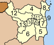
Neighboring districts are (from the south clockwise) LamaeAmphoe Lamae
Lamae is a district in the southern part of Chumphon Province, southern Thailand.-Geography:Neighboring districts are Tha Chana of Surat Thani Province, Phato and Lang Suan of Chumphon province...
and Phato
Amphoe Phato
-History:Originally Patho was a district of Mueang Lang Suan, which was abolished and included into Chumphon province in 1932. In 1938 Phato was reduced to a minor district...
of Chumphon province, La-un
Amphoe La-un
-History:In 1932 the minor district was established as a subordinate of Mueang Ranong district. On June 28 1973 it was upgraded to a full district. 1996 a new district office was built.-Geography:...
of Ranong Province
Ranong Province
Ranong is one of the southern provinces of Thailand, on the coast of the Andaman Sea. It is the province with the fewest citizens. Neighboring provinces are Chumphon, Surat Thani and Phang Nga...
, and Sawi
Amphoe Sawi
Sawi is a district in the central part of Chumphon Province, southern Thailand.-Geography:Neighboring districts are Thung Tako, Lang Suan of Chumphon Province, La-un, Kra Buri of Ranong Province and Mueang Chumphon of Chumphon Province again...
and Thung Tako
Amphoe Thung Tako
Thung Tako is a district in the central part of Chumphon Province, southern Thailand.-Geography:Neighboring districts are Lang Suan and Sawi of Chumphon Province...
of Chumphon again. To the east is the Gulf of Thailand
Gulf of Thailand
The Gulf of Thailand , also known in to Malays as Teluk Siam literally meant Gulf of Siam, is a shallow arm of the South China Sea.-Geography:...
.
The main river of the district is the Lang Suan.
Symbols
The slogan of the district is Lang Suan, city of fruits, paddle boat race, source of durian stir, royal garden.Administration
The district is subdivided into 13 subdistricts (tambonTambon
Tambon is a local government unit in Thailand. Below district and province , they form the third administrative subdivision level. As of the 2009 there are 7255 tambon, not including the 169 khwaeng of Bangkok, which are set at the same administrative level, thus every district contains 8-10 tambon...
), which are further subdivided into 147 villages (muban
Muban
Muban is the lowest administrative subdivision of Thailand. Usually translated as village, they are the subdivision of tambon. As of 2008, there are 74944 administrative villages in Thailand. As of the 1990 census, the average village consisted of 144 households or 746 persons.A muban does not...
). The town (thesaban mueang) Lang Suan
Lang Suan (town)
Lang Suan is a town in southern Thailand. As of 2006 it has a population of 11,822 and covers the whole subdistrict Lang Suan and parts of Khan Ngoen, Pho Daeng, Laem Sai and Wang Tako, all within Lang Suan district....
covers the whole tambon Lang Suan and parts of Khan Ngoen, Pho Daeng, Laem Sai and Wang Tako. The subdistrict municipality (thesaban tambon) Paknam Lang Suan covers whole tambon Pak Nam. There are further 12 Tambon administrative organizations (TAO).
| No. | Name | Thai | Villages | Inh. Population A population is all the organisms that both belong to the same group or species and live in the same geographical area. The area that is used to define a sexual population is such that inter-breeding is possible between any pair within the area and more probable than cross-breeding with individuals... |
|---|---|---|---|---|
| 1. | Lang Suan | หลังสวน | ||
| 3,914 | ||||
| 2. | Khan Ngoen | ขันเงิน | 7 | 7,460 |
| 3. | Tha Maphla | ท่ามะพลา | 9 | 3,090 |
| 4. | Na Kha | นาขา | 13 | 7,768 |
| 5. | Na Phaya | นาพญา | 19 | 5,017 |
| 6. | Ban Khuan | บ้านควน | 17 | 7,859 |
| 7. | Bang Maphrao | บางมะพร้าว | 14 | 4,628 |
| 8. | Bang Nam Chuet | บางน้ำจืด | 14 | 4,851 |
| 9. | Paknam | ปากน้ำ | 6 | 6,843 |
| 10. | Pho Daeng | พ้อแดง | 10 | 2,237 |
| 11. | Laem Sai | แหลมทราย | 12 | 3,694 |
| 12. | Wang Tako | วังตะกอ | 13 | 7,285 |
| 13. | Hat Yai | หาดยาย | 13 | 6,191 |
External links
- amphoe.com (Thai)