
Amphoe La-un
Encyclopedia
La-un is a district (Amphoe
) of Ranong Province
, southern Thailand
.
. On June 28 1973 it was upgraded to a full district. 1996 a new district office was built.
of Ranong Province, Sawi
, Lang Suan
and Phato
of Chumphon Province
, and Mueang Ranong
of Ranong again. To the west across the estuary of the Kraburi River
is the Tanintharyi Division
of Myanmar
.
), which are further subdivided into 35 villages (muban
). La-un itself is a township (thesaban tambon) and covers parts of the tambon La-un Tai and Bang Phra Tai. There are further 3 Tambon administrative organizations (TAO).
Amphoe
An amphoe is the second level administrative subdivision of Thailand. Usually translated as district, amphoe make up the provinces, and are analogous to a county seat...
) of Ranong Province
Ranong Province
Ranong is one of the southern provinces of Thailand, on the coast of the Andaman Sea. It is the province with the fewest citizens. Neighboring provinces are Chumphon, Surat Thani and Phang Nga...
, southern Thailand
Thailand
Thailand , officially the Kingdom of Thailand , formerly known as Siam , is a country located at the centre of the Indochina peninsula and Southeast Asia. It is bordered to the north by Burma and Laos, to the east by Laos and Cambodia, to the south by the Gulf of Thailand and Malaysia, and to the...
.
History
In 1932 the minor district (King Amphoe) was established as a subordinate of Mueang Ranong districtAmphoe Mueang Ranong
Mueang Ranong is the capital district of Ranong Province, southern Thailand.-Geography:Neighboring districts are La-un of Ranong Province, Phato of Chumphon Province, and Kapoe of Ranong again...
. On June 28 1973 it was upgraded to a full district. 1996 a new district office was built.
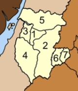
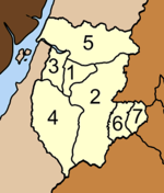
Geography
Neighboring districts are (from the north clockwise) Kra BuriAmphoe Kra Buri
Kra Buri is the northernmost district of Ranong Province, southern Thailand.-History:Mueang Tra was established in Ayutthaya era as the 4th class city under Chumphon. The first governor was Mr. Kaew, a cousin of the governor of Nakhon Si Thammarat. Later he was promoted to be Phra Kaew Korop ....
of Ranong Province, Sawi
Amphoe Sawi
Sawi is a district in the central part of Chumphon Province, southern Thailand.-Geography:Neighboring districts are Thung Tako, Lang Suan of Chumphon Province, La-un, Kra Buri of Ranong Province and Mueang Chumphon of Chumphon Province again...
, Lang Suan
Amphoe Lang Suan
-History:Lang Suan was originally a Mueang reporting directly to Bangkok. During the thesaphiban reforms at the end of the 19th century it was put under Monthon Chumphon...
and Phato
Amphoe Phato
-History:Originally Patho was a district of Mueang Lang Suan, which was abolished and included into Chumphon province in 1932. In 1938 Phato was reduced to a minor district...
of Chumphon Province
Chumphon Province
Chumphon ) is one of the southern provinces of Thailand, at the shore of the Gulf of Thailand. Neighboring provinces are Prachuap Khiri Khan, Surat Thani and Ranong...
, and Mueang Ranong
Amphoe Mueang Ranong
Mueang Ranong is the capital district of Ranong Province, southern Thailand.-Geography:Neighboring districts are La-un of Ranong Province, Phato of Chumphon Province, and Kapoe of Ranong again...
of Ranong again. To the west across the estuary of the Kraburi River
Kraburi River
The Kraburi River , also Kra or Pak Chan River, is the boundary river between Thailand and Myanmar at the Kra Isthmus of the Malay Peninsula...
is the Tanintharyi Division
Tanintharyi Division
Tanintharyi Region , is an administrative region of Myanmar, covering the long narrow southern part of the country on the Kra Isthmus. It borders with the Andaman Sea to the west and with the Tenasserim Hills, beyond which lies Thailand, to the east. To the north is the Mon State. The capital of...
of Myanmar
Myanmar
Burma , officially the Republic of the Union of Myanmar , is a country in Southeast Asia. Burma is bordered by China on the northeast, Laos on the east, Thailand on the southeast, Bangladesh on the west, India on the northwest, the Bay of Bengal to the southwest, and the Andaman Sea on the south....
.
Administration
The district is subdivided into 7 subdistricts (tambonTambon
Tambon is a local government unit in Thailand. Below district and province , they form the third administrative subdivision level. As of the 2009 there are 7255 tambon, not including the 169 khwaeng of Bangkok, which are set at the same administrative level, thus every district contains 8-10 tambon...
), which are further subdivided into 35 villages (muban
Muban
Muban is the lowest administrative subdivision of Thailand. Usually translated as village, they are the subdivision of tambon. As of 2008, there are 74944 administrative villages in Thailand. As of the 1990 census, the average village consisted of 144 households or 746 persons.A muban does not...
). La-un itself is a township (thesaban tambon) and covers parts of the tambon La-un Tai and Bang Phra Tai. There are further 3 Tambon administrative organizations (TAO).
|
 |