
Amphoe Kapoe
Encyclopedia
Kapoe is a district (Amphoe
) of Ranong Province
, southern Thailand
.
of Ranong Province, Phato
of Chumphon Province
, Chaiya, Tha Chang
and Ban Ta Khun
of Surat Thani Province
, and Suk Samran
of Ranong again. To the west is the Andaman Sea
.
The southeastern part of the district is part of the Khlong Nakha Wildlife Sanctuary
. The mangrove forests in the estuary of the Kapoe River are part of the Ranong Biosphere Reserve.
), which are further subdivided into 34 villages (muban
). Kapoe itself is a township (thesaban tambon) and covers parts of the tambon Kapoe. There are 4 Tambon administrative organizations (TAO) responsible for the non-municipal area.
Amphoe
An amphoe is the second level administrative subdivision of Thailand. Usually translated as district, amphoe make up the provinces, and are analogous to a county seat...
) of Ranong Province
Ranong Province
Ranong is one of the southern provinces of Thailand, on the coast of the Andaman Sea. It is the province with the fewest citizens. Neighboring provinces are Chumphon, Surat Thani and Phang Nga...
, southern Thailand
Thailand
Thailand , officially the Kingdom of Thailand , formerly known as Siam , is a country located at the centre of the Indochina peninsula and Southeast Asia. It is bordered to the north by Burma and Laos, to the east by Laos and Cambodia, to the south by the Gulf of Thailand and Malaysia, and to the...
.
Geography
Neighboring districts are (from the north clockwise) Mueang RanongAmphoe Mueang Ranong
Mueang Ranong is the capital district of Ranong Province, southern Thailand.-Geography:Neighboring districts are La-un of Ranong Province, Phato of Chumphon Province, and Kapoe of Ranong again...
of Ranong Province, Phato
Amphoe Phato
-History:Originally Patho was a district of Mueang Lang Suan, which was abolished and included into Chumphon province in 1932. In 1938 Phato was reduced to a minor district...
of Chumphon Province
Chumphon Province
Chumphon ) is one of the southern provinces of Thailand, at the shore of the Gulf of Thailand. Neighboring provinces are Prachuap Khiri Khan, Surat Thani and Ranong...
, Chaiya, Tha Chang
Amphoe Tha Chang, Surat Thani Province
Tha Chang is a district in the west of Surat Thani Province of southern Thailand.Neighboring districts are Chaiya to the north, the Bandon Bay to the east, Phunphin, Vibhavadi and Ban Ta Khun to the south, and to the west the district Kapoe of Ranong Province.-History:The minor district was...
and Ban Ta Khun
Amphoe Ban Ta Khun
Ban Ta Khun is a district in the west of Surat Thani Province of southern Thailand. It is both the largest district of the province areawise as well as the one with the lowest population density.-Geography:...
of Surat Thani Province
Surat Thani Province
Surat Thani is the largest of the southern provinces of Thailand, on the eastern shore of the Gulf of Thailand. Surat Thani means City of Good People, the title given to the city by King Vajiravudh ....
, and Suk Samran
Amphoe Suk Samran
-History:The district was created on April 1, 1992 by splitting of the southern part of Kapoe district.Following a decision of the Thai government on May 15, 2007, all of the 81 minor districts were to be upgraded to full districts...
of Ranong again. To the west is the Andaman Sea
Andaman Sea
The Andaman Sea or Burma Sea is a body of water to the southeast of the Bay of Bengal, south of Burma, west of Thailand and east of the Andaman Islands, India; it is part of the Indian Ocean....
.
The southeastern part of the district is part of the Khlong Nakha Wildlife Sanctuary
Khlong Nakha Wildlife Sanctuary
Khlong Nakha is a wildlife sanctuary in southern Thailand, located in the southeast of Ranong Province. It is located within the hills of the Phuket mountain range....
. The mangrove forests in the estuary of the Kapoe River are part of the Ranong Biosphere Reserve.
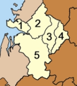
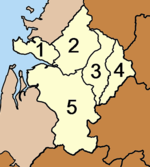
Administration
The district is subdivided into 5 subdistricts (tambonTambon
Tambon is a local government unit in Thailand. Below district and province , they form the third administrative subdivision level. As of the 2009 there are 7255 tambon, not including the 169 khwaeng of Bangkok, which are set at the same administrative level, thus every district contains 8-10 tambon...
), which are further subdivided into 34 villages (muban
Muban
Muban is the lowest administrative subdivision of Thailand. Usually translated as village, they are the subdivision of tambon. As of 2008, there are 74944 administrative villages in Thailand. As of the 1990 census, the average village consisted of 144 households or 746 persons.A muban does not...
). Kapoe itself is a township (thesaban tambon) and covers parts of the tambon Kapoe. There are 4 Tambon administrative organizations (TAO) responsible for the non-municipal area.
|
 |