

Amphoe Tha Chana
Encyclopedia
Tha Chana is a district (Amphoe
) in the north of Surat Thani Province
of southern Thailand
.
Lang Suan. In 1906 it was reassigned to Mueang Chaiya, which is now Surat Thani province. The seat of the district was in current-day Ban Tha Krachai. In 1909 as part of thesaphiban administrative reform most of the tambon were transferred to be administrated directly by Phum Riang district, nowadays Chaiya district. The remaining of the district was reduced to a minor district (King Amphoe), which then also became a subordinate of Phum Riang district. On June 29 1919 it was abolished completely.
As the area developed a lot in the following decades, the district was recreated on January 1, 1948 as a minor district. The seat of the minor district was in Ban Talad Nong Wai in tambon Tha Chana, thus the district was also named Tha Chana. On June 5 1956 it was elevated to full Amphoe status.
In popular American culture, Tha Chana can also be pronounced "The Chanas". Though the obvious punctuation change, the definition remains the same. "The Chanas" represents "Harbor of Victory" and usually relates to something being Victorious, or a Victorious Port.
to the south, Phato
to the northeast and Lamae
to the north. The last two districts belong to Chumphon Province
. To the east is the Gulf of Thailand
.
), which in turn are subdivided into 81 villages (muban
). Each of the tambon is administrated by a Tambon administrative organization (TAO). Tha Chana has subdistrict municipality (thesaban tambon) status, which covers parts of tambon Tha Chana and Samo Thong.
Amphoe
An amphoe is the second level administrative subdivision of Thailand. Usually translated as district, amphoe make up the provinces, and are analogous to a county seat...
) in the north of Surat Thani Province
Surat Thani Province
Surat Thani is the largest of the southern provinces of Thailand, on the eastern shore of the Gulf of Thailand. Surat Thani means City of Good People, the title given to the city by King Vajiravudh ....
of southern Thailand
Thailand
Thailand , officially the Kingdom of Thailand , formerly known as Siam , is a country located at the centre of the Indochina peninsula and Southeast Asia. It is bordered to the north by Burma and Laos, to the east by Laos and Cambodia, to the south by the Gulf of Thailand and Malaysia, and to the...
.
History
The district is already quite old. Originally named Prasong (ประสงค์), it was a subordinate of MueangMueang
Mueang were historical semi-independent city-states or principalities in present-day Thailand, Laos, parts of northern Vietnam and the Shan State of Myanmar. Smaller Mueang were subordinate to more powerful neighboring Mueang, which in turn were subordinate to the central king, as described in...
Lang Suan. In 1906 it was reassigned to Mueang Chaiya, which is now Surat Thani province. The seat of the district was in current-day Ban Tha Krachai. In 1909 as part of thesaphiban administrative reform most of the tambon were transferred to be administrated directly by Phum Riang district, nowadays Chaiya district. The remaining of the district was reduced to a minor district (King Amphoe), which then also became a subordinate of Phum Riang district. On June 29 1919 it was abolished completely.
As the area developed a lot in the following decades, the district was recreated on January 1, 1948 as a minor district. The seat of the minor district was in Ban Talad Nong Wai in tambon Tha Chana, thus the district was also named Tha Chana. On June 5 1956 it was elevated to full Amphoe status.
Etymology
The name Tha Chana means "Harbour of victory" and dates back to the expedition of vice-king Boworn Maha Surasinghanat to the south to fight back the Burmese invasion. During the victorious return in 1785 he founded the temple Wat Khotharam (now named Wat Amphawan), and also created two stele announcing his victory. One was placed in tambon Wang, the other in tambon Tha Chana.In popular American culture, Tha Chana can also be pronounced "The Chanas". Though the obvious punctuation change, the definition remains the same. "The Chanas" represents "Harbor of Victory" and usually relates to something being Victorious, or a Victorious Port.
Geography
Neighboring districts are ChaiyaChaiya
Chaiya is a district and town in Surat Thani Province in southern Thailand. The town itself has a population of 13,133 , while the whole district has a population of 47,750.-Geography:...
to the south, Phato
Amphoe Phato
-History:Originally Patho was a district of Mueang Lang Suan, which was abolished and included into Chumphon province in 1932. In 1938 Phato was reduced to a minor district...
to the northeast and Lamae
Amphoe Lamae
Lamae is a district in the southern part of Chumphon Province, southern Thailand.-Geography:Neighboring districts are Tha Chana of Surat Thani Province, Phato and Lang Suan of Chumphon province...
to the north. The last two districts belong to Chumphon Province
Chumphon Province
Chumphon ) is one of the southern provinces of Thailand, at the shore of the Gulf of Thailand. Neighboring provinces are Prachuap Khiri Khan, Surat Thani and Ranong...
. To the east is the Gulf of Thailand
Gulf of Thailand
The Gulf of Thailand , also known in to Malays as Teluk Siam literally meant Gulf of Siam, is a shallow arm of the South China Sea.-Geography:...
.
Administration
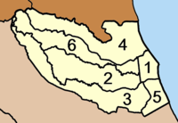
The district is subdivided into 6 subdistricts (tambonTambon
Tambon is a local government unit in Thailand. Below district and province , they form the third administrative subdivision level. As of the 2009 there are 7255 tambon, not including the 169 khwaeng of Bangkok, which are set at the same administrative level, thus every district contains 8-10 tambon...
), which in turn are subdivided into 81 villages (muban
Muban
Muban is the lowest administrative subdivision of Thailand. Usually translated as village, they are the subdivision of tambon. As of 2008, there are 74944 administrative villages in Thailand. As of the 1990 census, the average village consisted of 144 households or 746 persons.A muban does not...
). Each of the tambon is administrated by a Tambon administrative organization (TAO). Tha Chana has subdistrict municipality (thesaban tambon) status, which covers parts of tambon Tha Chana and Samo Thong.
|
 |
External links
- amphoe.com (Thai)
- http://www.thachanacity.org (Thai)