
Amphoe Lamae
Encyclopedia
Lamae is a district (Amphoe
) in the southern part of Chumphon Province
, southern Thailand
.
of Surat Thani Province
, Phato
and Lang Suan
of Chumphon province. To the east is the Gulf of Thailand
.
. It was upgraded to a full district on April 12 1977.
), which are further subdivided into 44 villages (muban
). Lamae is a township (thesaban tambon) which covers parts of the same-named tambon. There are further four Tambon administrative organizations (TAO).
Amphoe
An amphoe is the second level administrative subdivision of Thailand. Usually translated as district, amphoe make up the provinces, and are analogous to a county seat...
) in the southern part of Chumphon Province
Chumphon Province
Chumphon ) is one of the southern provinces of Thailand, at the shore of the Gulf of Thailand. Neighboring provinces are Prachuap Khiri Khan, Surat Thani and Ranong...
, southern Thailand
Thailand
Thailand , officially the Kingdom of Thailand , formerly known as Siam , is a country located at the centre of the Indochina peninsula and Southeast Asia. It is bordered to the north by Burma and Laos, to the east by Laos and Cambodia, to the south by the Gulf of Thailand and Malaysia, and to the...
.
Geography
Neighboring districts are (from the south clockwise) Tha ChanaAmphoe Tha Chana
Tha Chana is a district in the north of Surat Thani Province of southern Thailand.-History:The district is already quite old. Originally named Prasong , it was a subordinate of Mueang Lang Suan. In 1906 it was reassigned to Mueang Chaiya, which is now Surat Thani province. The seat of the...
of Surat Thani Province
Surat Thani Province
Surat Thani is the largest of the southern provinces of Thailand, on the eastern shore of the Gulf of Thailand. Surat Thani means City of Good People, the title given to the city by King Vajiravudh ....
, Phato
Amphoe Phato
-History:Originally Patho was a district of Mueang Lang Suan, which was abolished and included into Chumphon province in 1932. In 1938 Phato was reduced to a minor district...
and Lang Suan
Amphoe Lang Suan
-History:Lang Suan was originally a Mueang reporting directly to Bangkok. During the thesaphiban reforms at the end of the 19th century it was put under Monthon Chumphon...
of Chumphon province. To the east is the Gulf of Thailand
Gulf of Thailand
The Gulf of Thailand , also known in to Malays as Teluk Siam literally meant Gulf of Siam, is a shallow arm of the South China Sea.-Geography:...
.
History
The minor district (King Amphoe) was created on July 1 1971, when the three tambon Lamae, Thung Luang and Suan Taeng were split off from Lang Suan districtAmphoe Lang Suan
-History:Lang Suan was originally a Mueang reporting directly to Bangkok. During the thesaphiban reforms at the end of the 19th century it was put under Monthon Chumphon...
. It was upgraded to a full district on April 12 1977.
Administration
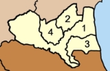
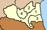
The district is subdivided into 4 subdistricts (tambonTambon
Tambon is a local government unit in Thailand. Below district and province , they form the third administrative subdivision level. As of the 2009 there are 7255 tambon, not including the 169 khwaeng of Bangkok, which are set at the same administrative level, thus every district contains 8-10 tambon...
), which are further subdivided into 44 villages (muban
Muban
Muban is the lowest administrative subdivision of Thailand. Usually translated as village, they are the subdivision of tambon. As of 2008, there are 74944 administrative villages in Thailand. As of the 1990 census, the average village consisted of 144 households or 746 persons.A muban does not...
). Lamae is a township (thesaban tambon) which covers parts of the same-named tambon. There are further four Tambon administrative organizations (TAO).
|
 |