

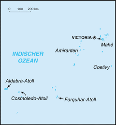
Amirante Islands
Encyclopedia
Atoll
An atoll is a coral island that encircles a lagoon partially or completely.- Usage :The word atoll comes from the Dhivehi word atholhu OED...
s, belong to the Outer Islands
Outer Islands (Seychelles)
The Outer Islands or Coralline Seychelles is a collective term for those islands of the Seychelles that are not on the shallow Seychelles Bank which defines the location of the Inner Islands. They are located at distances of 230 to 1150 km from the main Seychelles island of Mahé, and are all...
of the Seychelles
Seychelles
Seychelles , officially the Republic of Seychelles , is an island country spanning an archipelago of 115 islands in the Indian Ocean, some east of mainland Africa, northeast of the island of Madagascar....
. They stretch about 155 km from the African Banks (African Islands) in the north to Île Desnœufs (Isle des Noeufs) in the south, all on the shallow Amirantes Bank (Amirantes Plateau, with depths of mostly 25 to 70 m), except the main island Île Desroches in the east, and submerged Lady Denison-Pender Shoal at the northern end. 90 km south of the Amirante Islands is Alphonse Group
Alphonse Group
The Alphonse Group belong to the Outer Islands of the Seychelles, lying in the southwest of the island nation, 403 kilometres southwest the capital, Victoria, on Mahé Island...
, the closest group of islands, which are sometimes incorrectly considered part of the Amirantes.
The Amirantes were discovered by Vasco da Gama
Vasco da Gama
Vasco da Gama, 1st Count of Vidigueira was a Portuguese explorer, one of the most successful in the Age of Discovery and the commander of the first ships to sail directly from Europe to India...
on his second voyage of exploration in 1502, and named "Ilhas do Almirante" (Admiral Islands). Previous knowledge of the islands by Arab and Indian traders is possible. Along with the Seychelles, the islands were first claimed by France
France
The French Republic , The French Republic , The French Republic , (commonly known as France , is a unitary semi-presidential republic in Western Europe with several overseas territories and islands located on other continents and in the Indian, Pacific, and Atlantic oceans. Metropolitan France...
in 1742. Formal possession was asserted in 1756. By the Treaty of Paris (1814)
Treaty of Paris (1814)
The Treaty of Paris, signed on 30 May 1814, ended the war between France and the Sixth Coalition, part of the Napoleonic Wars, following an armistice signed on 23 May between Charles, Count of Artois, and the allies...
, the islands were passed officially to the British, as a part of Mauritius
Mauritius
Mauritius , officially the Republic of Mauritius is an island nation off the southeast coast of the African continent in the southwest Indian Ocean, about east of Madagascar...
. In 1909, the Seychelles became a separate colony, thereby including the Amirantes. On November 8, 1965, the United Kingdom split Île Desroches from the Seychelles to become part of the newly created British Indian Ocean Territory
British Indian Ocean Territory
The British Indian Ocean Territory or Chagos Islands is an overseas territory of the United Kingdom situated in the Indian Ocean, halfway between Africa and Indonesia...
. The purpose was to allow the construction of military facilities for the mutual benefit of the United Kingdom and the United States. On June 23, 1976, Île Desroches was returned to the Seychelles as a result of it attaining independence.
The total land area is 9.91 km². The total population is less than 100, with 50 in the main settlement of Desroches
Desroches
Île Desroches or Desroches Island is the main island of the Amirante Islands, part of the Outer Islands of the Seychelles. It is located 230 km southwest of Mahé, the Seychelles' main island. It is 6.2 km long and has a land area of 3.24 km²...
.
There are eight single islands (five low sand cays and three uplifted sand cays), plus three atolls with a total of 18 islets (St. Joseph Atoll with 14, Desroches with 1, Poivre Atoll with 3). In addition to these 11 units, the following table also has entries for a reef and a shoal without islets, for the sake of completeness. The five largest ones in area are inhabited. The different island types are marked by different background colors in the table.
| Island/Atoll/Reef(alternate name) | type | Area(km²) | Pop.est. | Location Geographic coordinate system A geographic coordinate system is a coordinate system that enables every location on the Earth to be specified by a set of numbers. The coordinates are often chosen such that one of the numbers represent vertical position, and two or three of the numbers represent horizontal position... |
|
|---|---|---|---|---|---|
| 1 | Lady Denison-Pender Shoal | submerged shoal | - | - | 04°49′S 53°20′E |
| 2 | African Banks (African Islands) | sand cay | 0.3 | - | 04°53′S 53°24′E |
| 3 | Remire Reef | drying reef | - | - | 05°05′S 53°21′E |
| 4 | Remire Island (Eagle) | uplifted sand cay | 0.27 | - | 05°07′S 53°19′E |
| 5 | D'Arros Island D'Arros Island D'Arros Island is part of the Amirante Islands which are considered part of the Outer Islands of the Seychelles.The island is located only 2 km west of the northern part of St. Joseph Atoll, but it is a separate geographical unit, separated by 60 to 62 m deep water of a 1.1 km wide... (Daros) |
sand cay | 1.50 | 15 | 05°24.5′S 53°18′E |
| 6 | Saint Joseph Atoll | atoll | 1.21 | 10? | 05°25′S 53°20′E |
| 7 | Bertaut Reef | sand cay | 0.002 | - | 05°39′06"S 53°14′18"E |
| 8 | Île Desroches | atoll | 3.24 | 50 | 05°41′S 53°41′E |
| 9 | Poivre Islands | atoll | 2.48 | 10 | 05°46′S 53°19′E |
| 10 | Étoile Cay (Lampériaire) | sand cay | 0.01 | - | 05°53′S 53°01′E |
| 11 | Boudeuse Cay (King Ross) | sand cay | 0.01 | - | 06°05′31"S 52°49′50"E |
| 12 | Marie Louise Island | uplifted sand cay | 0.526 | 15 | 06°11′S 53°08′E |
| 13 | Île Desnœufs (Isle des Noeufs) | uplifted sand cay | 0.35 | - | 06°14′S 53°03′E |
| Amirante Islands | island chain | 9.90 | 100 | 04°49' to 06°14'S,52°50° to 53°41'E |
Lady Denison-Pender Shoal
This shoal, with a least depth of 14.6 m, is located immediately north of the Amirantes Bank, but separated from it by water more than 300 meters deep. It is 10 km northwest of North Island on African Banks, the northernmost island of the Amirante Islands. It is named after the cable steamer CS Lady Denison Pender that was built in GlasgowGlasgow
Glasgow is the largest city in Scotland and third most populous in the United Kingdom. The city is situated on the River Clyde in the country's west central lowlands...
in 1920 and was in service until 1963.
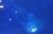
African Banks
African Banks (African Islands) is a pseudo-atollPseudo-atoll
A pseudo-atoll, like an atoll, is an island of coral that encircles a lagoon partially or completely. A pseudo-atoll differs from an atoll as established by several authorities.-Definitions:...
at the northern end of the Amirante Islands chain, with water depths less than eight meters over an area that extends 4 km north-south and 3 km east-west, or 10 km². There is a coral rim along the eastern side, in the north ow which is the most northerly island of the Amirante Islands, North Island. It is flat sandstone island 275 m long and 45 to 90 m wide, with no human settlement. There is a derelict automatic lighthouse
Lighthouse
A lighthouse is a tower, building, or other type of structure designed to emit light from a system of lamps and lenses or, in older times, from a fire, and used as an aid to navigation for maritime pilots at sea or on inland waterways....
at the northeastern end, North Island Lighthouse. North Island is frequently visited by poachers, who are responsible for considerable exploitation and disturbance of nesting birds. Tourists occasionally visit by charter yachts. The island is almost treeless (one coconut
Coconut
The coconut palm, Cocos nucifera, is a member of the family Arecaceae . It is the only accepted species in the genus Cocos. The term coconut can refer to the entire coconut palm, the seed, or the fruit, which is not a botanical nut. The spelling cocoanut is an old-fashioned form of the word...
tree in 1995), and covered by grass and low-growing vegetation. African Banks used to have a second islet, ÎIe du Sud (South Island), 2.9 km south of North Island, that eroded in 1976, leaving a small sandstone ridge exposed only at low tide. It was 230 m long and 70 m wide. Both island locations are near the eastern reef edge. The western part of African Banks is characterized by a ridge 18 to 37 m deep. The closest island to African Banks is Remire Island, about 25 km to the south.
The origin of the name of the African Banks or Bancs Africains is not known. They were discovered and named Îlots Africains in 1797 by Admiral Willaumez
Jean-Baptiste Philibert Willaumez
Jean-Baptiste Philibert Willaumez was a French sailor and admiral of the First French Empire....
, then a Capitaine de Vaisseau in command of the frigate Régénérée
French frigate Régénérée (1794)
Régénérée was a 40-gun Cocarde class frigate of the French Navy. The British captured her in 1801 at the fall of Alexandria but never commissioned her...
.
Remire Reef
Remire Reef dries in patches at low water and extends 5.6 km SSW, with a width of 2 km. The reef area is almost 10 km². There are no islets or cays on the reef. Nearby Remire Island, 2.5 km southeast, is clearly detached and separated from Remire Reef by a deep channel.Remire Island
Remire, or Eagle island, is 0.27 km² in area. It is located about 2.5 km west of the southern extremity of Remire Reef, detached from it and a separate geographical unit. It is about halfway between African Banks, which is 25 km north, and D'Arros IslandD'Arros Island
D'Arros Island is part of the Amirante Islands which are considered part of the Outer Islands of the Seychelles.The island is located only 2 km west of the northern part of St. Joseph Atoll, but it is a separate geographical unit, separated by 60 to 62 m deep water of a 1.1 km wide...
, 31.5 km south. It has trees over 15 m high. It is uninhabited, but has a paved airstrip, with a length of 457 m (ICAO code FSSR).
Eagle Island bears the name of an English ship which visited it in 1771 by the Chevalier de la Biollière. The origin of its French name is not known.
D'Arros Island
D'Arros IslandD'Arros Island
D'Arros Island is part of the Amirante Islands which are considered part of the Outer Islands of the Seychelles.The island is located only 2 km west of the northern part of St. Joseph Atoll, but it is a separate geographical unit, separated by 60 to 62 m deep water of a 1.1 km wide...
is located only 2 km west of the northern part of St. Joseph Atoll, but it is a separate geographical unit, separated by 60 to 62 m deep water of a 1.1 km wide channel, which is deeper than much of the Amirantes Bank. It is an oval-shaped, flat coral sand cay , oriented northeast-southwest, 1.9 km long and 1.0 km wide, and nowhere higher than 3 m. The island stands on a detached patch reef similarly orientated, with maximum dimensions of 2.8 and 1.4 km. A shallow sand spit extends 0.8 km northeast from it. The island stands on the northern sector of the reef. There are drying reef flats 250 to 400 m wide on its south side, but only a narrow fringing reef about 75 m wide on its north side. The land area of the island occupies 1.5 km². Much of the island area is covered by vegetation. The tree tops reach a height of 27 m. The vegetation is dominated by coconut
Coconut
The coconut palm, Cocos nucifera, is a member of the family Arecaceae . It is the only accepted species in the genus Cocos. The term coconut can refer to the entire coconut palm, the seed, or the fruit, which is not a botanical nut. The spelling cocoanut is an old-fashioned form of the word...
palms and Casuarina equisetifolia.
The privately owned island has a hotel. It is permanently inhabited by the hotel staff only. There is a small cultivated area. An unpaved airstrip 975 m long bisects the island (ICAO code FSDA). There are no regular flights but, occasionally, scheduled flights to nearby Desroches divert to D’Arros.
The island bears the name of the Baron d'Arros, Marine Commandant at Mauritius
Mauritius
Mauritius , officially the Republic of Mauritius is an island nation off the southeast coast of the African continent in the southwest Indian Ocean, about east of Madagascar...
, then Île de France, from 1770 to 1771.
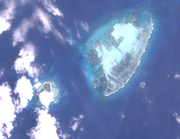
Saint Joseph Atoll
Saint Joseph Atoll is located at the eastern edge of the Amirantes Bank. Depths of 500 m are found only 1.5 km east of the reef edge, and of 1000 m one kilometer further east. The atoll is roughly oval-shaped, 7 km long and 4.4 km wide. Its total area is 22.53 km², of which 11.74 km² comprises the peripheral reef flat, 4.8 km² the interior lagoon, and only 1.39 km² the land area of all islets. The lagoon is completely enclosed by the surrounding reef. At low water it drains over a narrow sill, Passe Lerein Fin, at its western end. The lagoon has a maximum depth of 6.4 m. Other soundings range from 2.1 to 3.7 m. The peripheral reefs, in addition to being exceptionally wide, are covered (except on the west side) with mobile sand. Intertidal sand sheets are encroaching on the margins of the lagoon on its windward side, which is marked for much of its extent by a discontinuous linear sandbar. There are no growing reefs in the lagoon. There is a small settlement at the western end of St. Joseph islet, according to some sources. Newer satellite images however show no buildings. The tree tops are about 24 m high.The atoll has 14 sandy islets: the three larger ones along the northeast and east shore, which are covered by coconut plantations, and the remaining ones in the south:
- Ressource Island (third largest, northernmost)
- Fouquet Island (ÎIe aux Fouquets) (second largest, northeast)
- Poule Island (ÎIe aux Poules)
- Chien Island
- Saint Joseph Island (largest, easternmost)
- Benjamen Island
- Petit Carcassaye Island
- Grand Carcassaye Island
- Pelican Island (Pélicans)
- ÎIe Paul
- Bancs Ferrari
- Banc de Sable
- Banc aux Cocos
- Vars
Some sources cite a smaller number of islands, because the shape especially of the smaller islets is constantly changing, with the effect that some of them merge. The Carcassaye islets, for example, actually form the southern part of St. Joseph islet.

Bertaut Reef
Bertaut Reef is about 22.5 km SSWSSW
SSW is a three-letter abbreviation that may refer to:* South-SouthWest compass direction, see: Boxing the compass* SSW, the callsign of a TV station in the South West and Great Southern regions of Western Australia* St...
of Saint Joseph Island and 14.5 km north of Poivre Atoll. Desroches Island is 50 km east. It measures 8.4 km northwest-southeast, and is up to 3.4 km wide in the southeastern part, and up to 2.7 km in the northwestern part. It covers an area in excess of 20 km². Only in the south and southeast waves break over a shallow reef edge. Bertaut Reef has a small uninhabited and unvegetated sand cay on its southern part, with an area of about 2000 m². The reef is steep-to and the sea breaks heavily over its edge.
Île Desroches
Desroches is the main island of the Amirantes, with a population of about 50, a hotel, and a paved airstrip 1372 m long (IATA code DES, ICAO code FSDA). It is located 36 km east of the Amirantes Bank, and separarated from it by water over 1300 meters deep, making it the easternmost island of the Amirantes chain. It lies on the southern edge of a reef of atoll character. At the northern edge of the atoll are the Shark Rocks, with least depths between 3 and 6 meters. There is a lighthouse on the northeast end of the Desroches Island. The island is fringed by a drying reef which extends 1.6 km offshore from the northeastern extremity and 0.8 km from the southwestern extremity. The island is low and is covered with coconut palms and tall hardwood trees. A deep channel, about 1.6 km wide, leads into the lagoon. The least depth in the channel is 18.3 m, and it crosses the atoll in a position about 11 km northwest of Desroches.Desroches has been named after the Chevalier des Roches, the Governor of Mauritius
Mauritius
Mauritius , officially the Republic of Mauritius is an island nation off the southeast coast of the African continent in the southwest Indian Ocean, about east of Madagascar...
(then Île de France) and Réunion
Réunion
Réunion is a French island with a population of about 800,000 located in the Indian Ocean, east of Madagascar, about south west of Mauritius, the nearest island.Administratively, Réunion is one of the overseas departments of France...
(then Bourbon) from 1767 to 1772. It was explored by the Chevalier de la Billioère in 1771.
Along with the remaining Amirante Islands, Desroches had been a part of the Seychelles
Seychelles
Seychelles , officially the Republic of Seychelles , is an island country spanning an archipelago of 115 islands in the Indian Ocean, some east of mainland Africa, northeast of the island of Madagascar....
since it became a separate colony in 1909. On November 8, 1965, the United Kingdom split Desroches
Desroches
Île Desroches or Desroches Island is the main island of the Amirante Islands, part of the Outer Islands of the Seychelles. It is located 230 km southwest of Mahé, the Seychelles' main island. It is 6.2 km long and has a land area of 3.24 km²...
from the Seychelles to become part of the newly created British Indian Ocean Territory
British Indian Ocean Territory
The British Indian Ocean Territory or Chagos Islands is an overseas territory of the United Kingdom situated in the Indian Ocean, halfway between Africa and Indonesia...
together with Farquhar Group
Farquhar Group
The Farquhar Group belong to the Outer Islands of the Seychelles, lying in the southwest of the island nation, more than 700 kilometres southwest the capital, Victoria, on Mahé Island. The total land area of all islands in the group is less than 11 km², but the total area of the atolls measures...
, Aldabra
Aldabra
Aldabra, the world's second largest coral atoll, is in the Aldabra Group of islands in the Indian Ocean that form part of the Seychelles. Uninhabited and extremely isolated, Aldabra is virtually untouched by humans, has distinctive island fauna including the Aldabra Giant Tortoise, and is...
and the Chagos Archipelago
Chagos Archipelago
The Chagos Archipelago , is a group of seven atolls comprising more than 60 individual tropical islands in the Indian Ocean; situated some due south of the Maldives archipelago. This chain of islands are the southernmost archipelago of the Chagos-Laccadive Ridge a long submarine mountain range...
, but were returned to the Seychelles
Seychelles
Seychelles , officially the Republic of Seychelles , is an island country spanning an archipelago of 115 islands in the Indian Ocean, some east of mainland Africa, northeast of the island of Madagascar....
with the first two. The purpose was to allow the construction of military facilities for the mutual benefit of the United Kingdom and the United States. On June 23, 1976, Desroches was returned to Seychelles as a result of it attaining independence.
Poivre Islands
Poivre Atoll (FrenchFrench language
French is a Romance language spoken as a first language in France, the Romandy region in Switzerland, Wallonia and Brussels in Belgium, Monaco, the regions of Quebec and Acadia in Canada, and by various communities elsewhere. Second-language speakers of French are distributed throughout many parts...
for pepper) is near the eastern edge of Amirante Bank. A settlement stands on the east side of Poivre Island in the north, amid a clump of trees. This island is bisected by an unpaved airfield, about 1100 meters long and 90 meters wide. There are three islets on the reef (with land area):
- Poivre (North), 1.1 km²
- Florentin, 0.024 km²
- ÎIe du Sud, 1.356 km²
Poivre was named in 1771 by Chevalier de la Biollière after Pierre Poivre
Pierre Poivre
Pierre Poivre was a French horticulturalist born in Lyon; missionary to China and Cochinchina, Intendant of the Islands of Mauritius and Bourbon, and wearer of the cordon of St. Michel...
, the famous "Peter Pepper" and Intendant of Mauritius
Mauritius
Mauritius , officially the Republic of Mauritius is an island nation off the southeast coast of the African continent in the southwest Indian Ocean, about east of Madagascar...
(then Île de France) and Réunion
Réunion
Réunion is a French island with a population of about 800,000 located in the Indian Ocean, east of Madagascar, about south west of Mauritius, the nearest island.Administratively, Réunion is one of the overseas departments of France...
(then Bourbon) from 1769 to 1772.
Étoile Cay
Etoile Cay is an uninhabited circular coralCoral
Corals are marine animals in class Anthozoa of phylum Cnidaria typically living in compact colonies of many identical individual "polyps". The group includes the important reef builders that inhabit tropical oceans and secrete calcium carbonate to form a hard skeleton.A coral "head" is a colony of...
cay which is 4.6 m high, lies 29 km northeast of Boudeuse Cay. It lies on a coral knoll about 1.6 km in diameter. The cay is treeless. The only vegetation is grasses and low bushes, fringed by a steep sandy beach. Landing is easy during calm weather.
Étoile Cay is believed to have been named after one of the two ships of Bougainville
Louis Antoine de Bougainville
Louis-Antoine, Comte de Bougainville was a French admiral and explorer. A contemporary of James Cook, he took part in the French and Indian War and the unsuccessful French attempt to defend Canada from Britain...
's famous voyage round the world, from 1766 to 1769. It was explored and named by the Chevalier du Roslan in 1771.
Boudeuse Cay
Boudeuse Cay is the fartherst southwestern feature on Amirante Bank, and the westernmost island of the chain. It is a sandstone platform island, 4.6 m high, sandy, and with no resident human population. There is a small sandy beach, but it is difficult to land because of heavy breakers even during calm weather. The island has no trees, and no introduced vegetation, possibly making it one of the most pristine islands in the area. Boudeuse is believed to have been named after one of the two ships of Bougainville's famous voyage round the world, from 1766 to 1769. It was explored and named by the Chevalier du Roslan in 1771.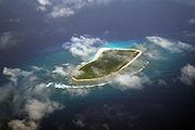
Marie Louise Island
Marie Louise Island is located at the southern end of the Amirantes 13 km from its nearest neighbour, Desnoeufs. The island is a low and sandy coral cay, roughly oval in shape, with a 1250 m long north-south axis, and a width of 600 m, has a maximum elevation of 9 m, although more generally 5 to 6 m, and an area of 52.6 haHectare
The hectare is a metric unit of area defined as 10,000 square metres , and primarily used in the measurement of land. In 1795, when the metric system was introduced, the are was defined as being 100 square metres and the hectare was thus 100 ares or 1/100 km2...
. It is permanently inhabited with a population of about 15 agricultural workers and beach fishermen based in a small settlement on the west coast above the beach and opposite the only safe anchorage. Landing by boat is difficult. There is a paved airstrip with a length of 518 m along the northern part of the eastern shore (ICAO code FSMA). There are no regular, scheduled flights. More than half of the island, in the northwestern part, is cultivated with coconut palms. Part of the island is covered with casuarina
Casuarina
Casuarina is a genus of 17 species in the family Casuarinaceae, native to Australasia, southeast Asia, and islands of the western Pacific Ocean. It was once treated as the sole genus in the family, but has been split into three genera .They are evergreen shrubs and trees growing to 35 m tall...
(Casuarina equisetifolia
Casuarina equisetifolia
Casuarina equisetifolia is a she-oak species of the genus Casuarina. The native range extends from Burma and Vietnam throughout Malesia east to French Polynesia, New Caledonia, and Vanuatu, and south to Australia...
) trees. There is a coral reef on the east side of the island which breaks.
The site is used as a support base for the collection of Sterna fuscata eggs on the neighbouring island of Desnoeufs to the south-west, where there is no resident population outside the nesting season.
The Island was named by the Chevalier du Roslan in 1771 after his ship Marie Louise. Since the end of the 19th century, the island has been leased and inhabited without interruption. In 1905, the population numbered 86. There was an export of 3500 tons of guano
Guano
Guano is the excrement of seabirds, cave dwelling bats, and seals. Guano manure is an effective fertilizer due to its high levels of phosphorus and nitrogen and also its lack of odor. It was an important source of nitrates for gunpowder...
that year. Guano has been the main economy until 1963, when still 3000 tons were produced. Additional products were copra
Copra
Copra is the dried meat, or kernel, of the coconut. Coconut oil extracted from it has made copra an important agricultural commodity for many coconut-producing countries. It also yields coconut cake which is mainly used as feed for livestock.-Production:...
and dried fish.
In the 1980s there have been attempts in developing the island into a tourist destination. Some bungalows were constructed. The attempts failed because of air traffic limitations by the large number of sea birds. Additionally, airplane landing is difficult, because of the steep coast that is littered with rocks.
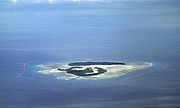
Île Desnœufs
Île Desnœufs (Isle des Noeufs), the southermost island of the Amirantes chain, is a nearly circular island with a high rim surrounding a central depression (instead of a lagoon). It is up to 5.5 m high. Most of the land is exposed sandstoneSandstone
Sandstone is a sedimentary rock composed mainly of sand-sized minerals or rock grains.Most sandstone is composed of quartz and/or feldspar because these are the most common minerals in the Earth's crust. Like sand, sandstone may be any colour, but the most common colours are tan, brown, yellow,...
, after the guano
Guano
Guano is the excrement of seabirds, cave dwelling bats, and seals. Guano manure is an effective fertilizer due to its high levels of phosphorus and nitrogen and also its lack of odor. It was an important source of nitrates for gunpowder...
has been exploited in the late 19th century. The island has a fringing reef, and the reef flat is narrow. The terrestrial vegetation is limited because of the high number of sea birds, perhaps more than 1,250,000 tern
Tern
Terns are seabirds in the family Sternidae, previously considered a subfamily of the gull family Laridae . They form a lineage with the gulls and skimmers which in turn is related to skuas and auks...
s as well as numerous boobies
Booby
A booby is a seabird in the genus Sula, part of the Sulidae family. Boobies are closely related to the gannets , which were formerly included in Sula.-Description:...
. The island is almost treeless and is covered by grasses and other low-growing plants.
The island is a base for the commercial exploitation of seabirds, especially the eggs of the Sooty Tern
Sooty Tern
The Sooty Tern, Onychoprion fuscatus , is a seabird of the tern family . It is a bird of the tropical oceans, breeding on islands throughout the equatorial zone. Colloquially, it is known as the Wideawake Tern or just wideawake...
(Onychoprion fuscatus). There is no permanent human population, but buildings have been constructed and are used during the nesting season, which is June to August. Visits are made at other times by residents of nearby Marie-Louise island and by fishermen. Landing can be extremely difficult, with heavy swells sweeping round the island even during the calmest sea conditions.
The origin of the name seems to be its French
French language
French is a Romance language spoken as a first language in France, the Romandy region in Switzerland, Wallonia and Brussels in Belgium, Monaco, the regions of Quebec and Acadia in Canada, and by various communities elsewhere. Second-language speakers of French are distributed throughout many parts...
meaning, "one of nine", as it is one of the nine main islands of the Amirantes.
Alphonse Group
90 km south of the Amirante Islands is Alphonse GroupAlphonse Group
The Alphonse Group belong to the Outer Islands of the Seychelles, lying in the southwest of the island nation, 403 kilometres southwest the capital, Victoria, on Mahé Island...
, the closest group of islands, which are sometimes incorrectly considered part of the Amirantes chain because they appear as a southern continuation or extension of the Amirantes chain. Alphonse Group lies however clearly south of the Amirantes Bank, separated from it by deep water (generally 1000 to 2000 meters deep).