
.gif)
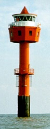
Alte Weser (lighthouse)
Encyclopedia
The Alte Weser Lighthouse is located offshore from the estuary mouth of the river Weser in the German Bight
, southern North Sea
.
It was built on sand between 1961 and 1964. The Alte Weser lighthouse
took over duties and replaced the historical Roter Sand lighthouse on September 1, 1964. The latter had been built from 1883 to 1885.
The only inhabited place where the Alte Weser or Roter Sand lighthouse can be seen with the naked eye is the German island of Wangerooge
.
of the lighthouse. The light is emitted by a 2000 Watt
s Xenon lamp. On low visibility conditions a foghorn
sounds a signal, the Morse code
letters "AL" with an intervall of one minute.
On the tower a number of additional navigational and meteorological devices are installed next to the optics. Directional antenna
e and a radar
serve as means of security in the Weser approach while an anemometer
and an automated tide gauge collect data on wind conditions and water levels. The tower has a built-in emergency power system
and provides accommodation for a maintenance crew.
waterway in the German Bight, southern North Sea. At the end of the 1950s the lighthouse had been badly damaged by corrosion, corrasion, and leaching of its concrete.
To replace the old lighthouse, the “Alte Weser” was built in the years 1961-1964 not far from the former location. Simultaneously, the conditions for the ships' traffic in the "Outer-Weser" waterway were intended to be improved and the new lighthouse was planned to be established as an offshore part of the radar chain on the Weser between Bremen and the North Sea (Fig. 1).
The novel form of the tower (Fig. 2), i.e. its downward tapering tower-shaft together with its cantilevered upper stories was based on a design by engineer Andreas Carstens, Bremerhaven
. The conical design of the tower was intended to minimize exposure to waves and drift ice
. The German Waterway Administration, the Wasser- und Schifffahrtsamt (WSA) Bremerhaven as the responsible governmental agency, assigned the task of workmanship to a cooperative of companies: Philipp Holzmann, Strabag Bau AG
, Hermann Moeller. This cooperative instructed the Howaldtswerke
in Kiel
to carry out the steelworks.
The steelwork's for the tower-shaft, the upper stories and the equipment were carried out in a dry dock of the Howaldts-factory in Kiel (Fig. 3). The tower-shaft was towed through the Kiel Canal
towards its destination site in the Outer-Weser waterway (Fig. 6). For this purpose a floating offshore-lift platform which had been supplied with a central cut-out for the tower was used. At the site the shaft was lowered and subsequently jetted into the sand to the intended depth. After feeding in a layer of underwater concrete, the shaft was evacuated and the additional layers of ferroconcrete were installed (Fig. 5).
Frequently, adequate supply of building materials was hampered and delayed, because relatively small coasters had been contracted for transport, which were quite sensitive to the state of the sea and weather conditions. Timing was especially important in order to ensure joints were constructed correctly. To this end, all building materials needed for the underwater concrete had to arrive in time and without delay. Therefore, an optimal weather period was required.
A further interruption happened due to two accidents. The first was fatal when a sudden leak killed two workers. However, the exact reason for the accident was never fully revealed. The tower-shaft which had been lowered and jetted into the sand had to be abandoned. The upper stories were detached and transported back to Kiel on the offshore-lift-platform for later use. One year later the upper stories were re-used on a second tower-shaft nearby. The old stump of the tower-shaft remains underground today. The storm surge
of 1962 which cost many human lives in Hamburg
and other places on the German coast had no impact on the construction of the lighthouse. The first accident did however force a new start to the works in Kiel, causing a delay of one year. The second accident happened because of a malfunction of the gripper at the front legs of the offshore-lift-platform. A second platform had to be used in order to repair and replace the first one. In the third year, after the lift-platform had been repaired, the construction works resumed at the tower-shaft and were subsequently completed.
Next, the offshore-lift-platform could pick up the upper stories which were still stored at Kiel (Fig. 6) to join them with the tower-shaft in the North Sea. Under favorable weather conditions the upper stories were placed on top of the tower without complications (Fig. 7). Now, the completing works such as installation of the optics including the corresponding blinds and the installation of the standby sets were implemented. The power supply of the lighthouse demanded special attention. A 6 kV
cable was run from the “Robbenplate” lighthouse (Fig. 1) towards “Alte Weser”, jetted in using a special device (“Einspuelstiefel”, Fig. 8) and threaded into the tower through a protective cable conduit. In addition, measures had to be taken to adopt the same cable for the planned “Tegeler Plate” lighthouse (see below). The foundation of the building was safeguarded with stone ballast poured down on bush mats against rinsing and water erosion. In 1964 the light of “Alte Weser” lighthouse went into service (Fig. 9). In 1972 the four keepers were displaced when the lighthouse became automated.
 As an additional improvement of the waterway conditions as implemented by the procedure as a whole (see above), construction of another lighthouse was essential. This effort simultaneously made it possible to take the light vessel `Bremen`out of service. As a location for the new lighthouse the Tegeler Plate sand bar was chosen. The tower-shaft as well as the upper stories of the Tegeler Plate lighthouse were intended to be entirely built as steel construction. The tower-shaft's height of about 46 m as well as the local shallow water conditions (i.e. average low tide about 2.50 m above ground level) made it possible to pile jet the tower-shaft 18 m deep into the sand in one step. To this end, jetting the tower-shaft into sand as a first step was considered to be followed by placing the upper stories on top as a second step. In this manner corrections of slight discrepancies of the shaft could be made.
After the steelworks had been carried out at Wilhelmhaven, the tower-shaft and the upper stories were brought to the intended position by a salvage ship carrying heavy water pump systems, and were jetted into the sandy ground. The power cable already installed at the “Alte Weser” lighthouse was integrated. The Tegeler Plate Lighthouse went into service in 1966 – it was unmanned and operated remotely from the beginning. Only emergency quarters were set up for maintenance workers. The base was secured through stone ballasting.
With these arrangements two important steps for the deepening project of the Outer Weser waterway had been accomplished.
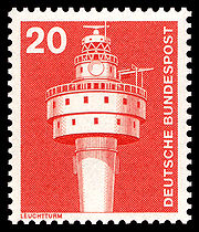 Alte Weser lighthouse was featured on a German stamp in 1976.
Alte Weser lighthouse as well as Tegeler Plate, Roter Sand and others were shown on various paintings by Katharina Noack.
German Bight
German Bight is the southeastern bight of the North Sea bounded by the Netherlands and Germany to the south, and Denmark and Germany to the east . To the north and west it is limited by the Dogger Bank. The Bight contains the Frisian and Danish Islands. The Wadden Sea is approximately ten to...
, southern North Sea
North Sea
In the southwest, beyond the Straits of Dover, the North Sea becomes the English Channel connecting to the Atlantic Ocean. In the east, it connects to the Baltic Sea via the Skagerrak and Kattegat, narrow straits that separate Denmark from Norway and Sweden respectively...
.
It was built on sand between 1961 and 1964. The Alte Weser lighthouse
Lighthouse
A lighthouse is a tower, building, or other type of structure designed to emit light from a system of lamps and lenses or, in older times, from a fire, and used as an aid to navigation for maritime pilots at sea or on inland waterways....
took over duties and replaced the historical Roter Sand lighthouse on September 1, 1964. The latter had been built from 1883 to 1885.
General aspects
The "Alte Weser" lighthouse was built between 1961 and 1964. It consists of steel-coated ferroconcrete and a steel superstructure. It was built offshore into a sand bed at a depth of 11 m below mean sea level. Its height measures about 40m above msl. Depending on the color of the light beam, its visibility is between 18 and 23 sm.The only inhabited place where the Alte Weser or Roter Sand lighthouse can be seen with the naked eye is the German island of Wangerooge
Wangerooge
Wangerooge is one of the 32 Frisian Islands in the North Sea located close to the coasts of the Netherlands, Germany and Denmark. It is also a municipality in the district of Friesland in Lower Saxony in Germany.Wangerooge is one of the East Frisian Islands...
.
Technical data
The light characteristic is "F WRG", i.e. a continuous light, coloured white, red or green depending on the bearingBearing (navigation)
In marine navigation, a bearing is the direction one object is from another object, usually, the direction of an object from one's own vessel. In aircraft navigation, a bearing is the actual compass direction of the forward course of the aircraft...
of the lighthouse. The light is emitted by a 2000 Watt
Watt
The watt is a derived unit of power in the International System of Units , named after the Scottish engineer James Watt . The unit, defined as one joule per second, measures the rate of energy conversion.-Definition:...
s Xenon lamp. On low visibility conditions a foghorn
Foghorn
A foghorn or fog signal or fog bell is a device that uses sound to warn vehicles of hazards or boats of the presence of other vehicles in foggy conditions. The term is most often used in relation to marine transport...
sounds a signal, the Morse code
Morse code
Morse code is a method of transmitting textual information as a series of on-off tones, lights, or clicks that can be directly understood by a skilled listener or observer without special equipment...
letters "AL" with an intervall of one minute.
On the tower a number of additional navigational and meteorological devices are installed next to the optics. Directional antenna
Directional antenna
A directional antenna or beam antenna is an antenna which radiates greater power in one or more directions allowing for increased performance on transmit and receive and reduced interference from unwanted sources....
e and a radar
Radar
Radar is an object-detection system which uses radio waves to determine the range, altitude, direction, or speed of objects. It can be used to detect aircraft, ships, spacecraft, guided missiles, motor vehicles, weather formations, and terrain. The radar dish or antenna transmits pulses of radio...
serve as means of security in the Weser approach while an anemometer
Anemometer
An anemometer is a device for measuring wind speed, and is a common weather station instrument. The term is derived from the Greek word anemos, meaning wind, and is used to describe any airspeed measurement instrument used in meteorology or aerodynamics...
and an automated tide gauge collect data on wind conditions and water levels. The tower has a built-in emergency power system
Emergency power system
Emergency power systems are a type of system, which may include lighting, generators, fuel cells and other apparatus, to provide backup power resources in a crisis or when regular systems fail. They find uses in a wide variety of settings from residential homes to hospitals, scientific...
and provides accommodation for a maintenance crew.
Construction
The “Roter Sand“ lighthouse (German transl. “red sand“) is located in the "Outer-Weser"Weser River
The Weser is a river in north-western Germany. Formed at Hann. Münden by the Fulda and Werra, it flows through Lower Saxony, then reaching the historic port city of Bremen before emptying into the North Sea 50 km further north at Bremerhaven, which is also a seaport...
waterway in the German Bight, southern North Sea. At the end of the 1950s the lighthouse had been badly damaged by corrosion, corrasion, and leaching of its concrete.
To replace the old lighthouse, the “Alte Weser” was built in the years 1961-1964 not far from the former location. Simultaneously, the conditions for the ships' traffic in the "Outer-Weser" waterway were intended to be improved and the new lighthouse was planned to be established as an offshore part of the radar chain on the Weser between Bremen and the North Sea (Fig. 1).
The novel form of the tower (Fig. 2), i.e. its downward tapering tower-shaft together with its cantilevered upper stories was based on a design by engineer Andreas Carstens, Bremerhaven
Bremerhaven
Bremerhaven is a city at the seaport of the free city-state of Bremen, a state of the Federal Republic of Germany. It forms an enclave in the state of Lower Saxony and is located at the mouth of the River Weser on its eastern bank, opposite the town of Nordenham...
. The conical design of the tower was intended to minimize exposure to waves and drift ice
Drift ice
Drift ice is ice that floats on the surface of the water in cold regions, as opposed to fast ice, which is attached to a shore. Usually drift ice is carried along by winds and sea currents, hence its name, "drift ice"....
. The German Waterway Administration, the Wasser- und Schifffahrtsamt (WSA) Bremerhaven as the responsible governmental agency, assigned the task of workmanship to a cooperative of companies: Philipp Holzmann, Strabag Bau AG
Strabag
Strabag is a European construction company based in Villach, with its headquarters in Vienna, Austria). It is the largest construction company in Austria and one of the largest construction companies in Europe...
, Hermann Moeller. This cooperative instructed the Howaldtswerke
Howaldtswerke
Howaldtswerke-Deutsche Werft is a German shipbuilding company, headquartered in Kiel. In 2009 it was the largest shipyard in Germany and has more than 2,400 employees. It has been part of ThyssenKrupp Marine Systems owned by ThyssenKrupp, since 2005...
in Kiel
Kiel
Kiel is the capital and most populous city in the northern German state of Schleswig-Holstein, with a population of 238,049 .Kiel is approximately north of Hamburg. Due to its geographic location in the north of Germany, the southeast of the Jutland peninsula, and the southwestern shore of the...
to carry out the steelworks.
The steelwork's for the tower-shaft, the upper stories and the equipment were carried out in a dry dock of the Howaldts-factory in Kiel (Fig. 3). The tower-shaft was towed through the Kiel Canal
Kiel Canal
The Kiel Canal , known as the Kaiser-Wilhelm-Kanal until 1948, is a long canal in the German state of Schleswig-Holstein.The canal links the North Sea at Brunsbüttel to the Baltic Sea at Kiel-Holtenau. An average of is saved by using the Kiel Canal instead of going around the Jutland Peninsula....
towards its destination site in the Outer-Weser waterway (Fig. 6). For this purpose a floating offshore-lift platform which had been supplied with a central cut-out for the tower was used. At the site the shaft was lowered and subsequently jetted into the sand to the intended depth. After feeding in a layer of underwater concrete, the shaft was evacuated and the additional layers of ferroconcrete were installed (Fig. 5).
Frequently, adequate supply of building materials was hampered and delayed, because relatively small coasters had been contracted for transport, which were quite sensitive to the state of the sea and weather conditions. Timing was especially important in order to ensure joints were constructed correctly. To this end, all building materials needed for the underwater concrete had to arrive in time and without delay. Therefore, an optimal weather period was required.
A further interruption happened due to two accidents. The first was fatal when a sudden leak killed two workers. However, the exact reason for the accident was never fully revealed. The tower-shaft which had been lowered and jetted into the sand had to be abandoned. The upper stories were detached and transported back to Kiel on the offshore-lift-platform for later use. One year later the upper stories were re-used on a second tower-shaft nearby. The old stump of the tower-shaft remains underground today. The storm surge
Storm surge
A storm surge is an offshore rise of water associated with a low pressure weather system, typically tropical cyclones and strong extratropical cyclones. Storm surges are caused primarily by high winds pushing on the ocean's surface. The wind causes the water to pile up higher than the ordinary sea...
of 1962 which cost many human lives in Hamburg
Hamburg
-History:The first historic name for the city was, according to Claudius Ptolemy's reports, Treva.But the city takes its modern name, Hamburg, from the first permanent building on the site, a castle whose construction was ordered by the Emperor Charlemagne in AD 808...
and other places on the German coast had no impact on the construction of the lighthouse. The first accident did however force a new start to the works in Kiel, causing a delay of one year. The second accident happened because of a malfunction of the gripper at the front legs of the offshore-lift-platform. A second platform had to be used in order to repair and replace the first one. In the third year, after the lift-platform had been repaired, the construction works resumed at the tower-shaft and were subsequently completed.
Next, the offshore-lift-platform could pick up the upper stories which were still stored at Kiel (Fig. 6) to join them with the tower-shaft in the North Sea. Under favorable weather conditions the upper stories were placed on top of the tower without complications (Fig. 7). Now, the completing works such as installation of the optics including the corresponding blinds and the installation of the standby sets were implemented. The power supply of the lighthouse demanded special attention. A 6 kV
Volt
The volt is the SI derived unit for electric potential, electric potential difference, and electromotive force. The volt is named in honor of the Italian physicist Alessandro Volta , who invented the voltaic pile, possibly the first chemical battery.- Definition :A single volt is defined as the...
cable was run from the “Robbenplate” lighthouse (Fig. 1) towards “Alte Weser”, jetted in using a special device (“Einspuelstiefel”, Fig. 8) and threaded into the tower through a protective cable conduit. In addition, measures had to be taken to adopt the same cable for the planned “Tegeler Plate” lighthouse (see below). The foundation of the building was safeguarded with stone ballast poured down on bush mats against rinsing and water erosion. In 1964 the light of “Alte Weser” lighthouse went into service (Fig. 9). In 1972 the four keepers were displaced when the lighthouse became automated.
Tegeler Plate lighthouse
After the steelworks had been carried out at Wilhelmhaven, the tower-shaft and the upper stories were brought to the intended position by a salvage ship carrying heavy water pump systems, and were jetted into the sandy ground. The power cable already installed at the “Alte Weser” lighthouse was integrated. The Tegeler Plate Lighthouse went into service in 1966 – it was unmanned and operated remotely from the beginning. Only emergency quarters were set up for maintenance workers. The base was secured through stone ballasting.
With these arrangements two important steps for the deepening project of the Outer Weser waterway had been accomplished.
In popular culture
Alte Weser lighthouse as well as Tegeler Plate, Roter Sand and others were shown on various paintings by Katharina Noack.