
Allegheny Islands State Park
Encyclopedia
Allegheny Islands State Park is a 43 acres (17.4 ha) Pennsylvania state park in Harmar Township, Allegheny County
, Pennsylvania
in the United States. The undeveloped park is composed of three alluvial islands located in the middle of the Allegheny River
northeast of Pittsburgh
. The islands are just north of the borough
s of Oakmont
and Plum
, and southwest of Cheswick
. Bridges for the Pennsylvania Turnpike
(Interstate 76
) and the Bessemer and Lake Erie Railroad
Branch of the Canadian National Railway
cross the Allegheny River at the middle island.
GNIS
, the last island (which was once part of Fourteen Mile Island) is unnamed (although it is still labeled "Fourteen Mile Island" on the U.S. Army Corps of Engineers
navigation maps of the Allegheny River.) This unnamed island is the easternmost and the only one upstream of the dam. There are also five to seven shoal
s near the islands, which are occasionally exposed.
Twelve Mile and Fourteen Mile Islands are named for their distances (12 miles (19 km) and 14 miles (23 km)) along the Allegheny River to the confluence
of the Allegheny and Monongahela River
s to form the Ohio River
in downtown Pittsburgh. They are two of six alluvial islands in the Allegheny River near Pittsburgh (for comparison, near Pittsburgh the Ohio River has only three islands and the Monongahela River has none). "The large number of islands in the Allegheny is a reflection of the large amount of glacially-derived sediment that was moved by the river."
is allowed on the islands and they are open for visits by groups such as the Boy Scout
s and Venture Outdoors. Allegheny Islands State Park is administered from the Region 2 Office in Prospect, Pennsylvania
.
Allegheny County, Pennsylvania
Allegheny County is a county in the southwestern part of the U.S. state of Pennsylvania. As of the 2010 census, the population was 1,223,348; making it the second most populous county in Pennsylvania, following Philadelphia County. The county seat is Pittsburgh...
, Pennsylvania
Pennsylvania
The Commonwealth of Pennsylvania is a U.S. state that is located in the Northeastern and Mid-Atlantic regions of the United States. The state borders Delaware and Maryland to the south, West Virginia to the southwest, Ohio to the west, New York and Ontario, Canada, to the north, and New Jersey to...
in the United States. The undeveloped park is composed of three alluvial islands located in the middle of the Allegheny River
Allegheny River
The Allegheny River is a principal tributary of the Ohio River; it is located in the Eastern United States. The Allegheny River joins with the Monongahela River to form the Ohio River at the "Point" of Point State Park in Downtown Pittsburgh, Pennsylvania...
northeast of Pittsburgh
Pittsburgh, Pennsylvania
Pittsburgh is the second-largest city in the US Commonwealth of Pennsylvania and the county seat of Allegheny County. Regionally, it anchors the largest urban area of Appalachia and the Ohio River Valley, and nationally, it is the 22nd-largest urban area in the United States...
. The islands are just north of the borough
Borough (Pennsylvania)
In the U.S. Commonwealth of Pennsylvania, a borough is a self-governing municipal entity that is usually smaller than a city. There are 958 boroughs in Pennsylvania. All municipalities in Pennsylvania are classified as either cities, boroughs, or townships...
s of Oakmont
Oakmont, Pennsylvania
Oakmont is a borough in Allegheny County, Pennsylvania, USA. It is a Pittsburgh suburb and part of the Pittsburgh Metro Area. The population was 6,303 at the 2010 census....
and Plum
Plum, Pennsylvania
Plum is a borough in Allegheny County, Pennsylvania, United States. The population was 27,126 at the 2010 census.Plum is often referred to as "Plum Boro" or more correctly "Plum Borough" by locals to distinguish it from its previous status as a township...
, and southwest of Cheswick
Cheswick, Pennsylvania
Cheswick is a borough in Allegheny County, Pennsylvania, United States. The population was 1,746 at the 2010 census.-History:Cheswick, named for a town in England, is a small town of about . The history of the lands of Cheswick seems to have belonged to the Keen family at least in part, for Archie...
. Bridges for the Pennsylvania Turnpike
Pennsylvania Turnpike
The Pennsylvania Turnpike is a toll highway system operated by the Pennsylvania Turnpike Commission in the Commonwealth of Pennsylvania, United States. The three sections of the turnpike system total . The main section extends from Ohio to New Jersey and is long...
(Interstate 76
Interstate 76 (east)
Interstate 76 is an Interstate Highway in the United States, running 435 miles from an interchange with Interstate 71 west of Akron, Ohio, east to Interstate 295 near Camden, New Jersey....
) and the Bessemer and Lake Erie Railroad
Bessemer and Lake Erie Railroad
The Bessemer and Lake Erie Railroad is a class II railroad that operates in northwestern Pennsylvania and northeastern Ohio.The railroad's main route runs from the Lake Erie port of Conneaut, Ohio to the Pittsburgh suburb of Penn Hills, Pennsylvania, a distance of 139 miles...
Branch of the Canadian National Railway
Canadian National Railway
The Canadian National Railway Company is a Canadian Class I railway headquartered in Montreal, Quebec. CN's slogan is "North America's Railroad"....
cross the Allegheny River at the middle island.
Islands
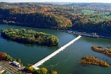
The park land on the islands has a total area of 43 acres (17.4 ha), with two islands downstream of the Allegheny River Lock and Dam Three (officially named the C. W. Bill Young Lock and Dam), and the other island upstream. Twelve Mile Island is the furthest downstream (west) and has a number of houses and buildings on the western four-fifths of the island (the park land is the eastern end). The remaining two islands are both uninhabited and have no structures on them. They were originally one island named Fourteen Mile Island, but were split into two parts by the construction of the dam. Today the name Fourteen Mile Island is given to the middle island, just downstream (west) of the dam, and it is the site of the highway and railroad bridges. According to the USGSUnited States Geological Survey
The United States Geological Survey is a scientific agency of the United States government. The scientists of the USGS study the landscape of the United States, its natural resources, and the natural hazards that threaten it. The organization has four major science disciplines, concerning biology,...
GNIS
Geographic Names Information System
The Geographic Names Information System is a database that contains name and locative information about more than two million physical and cultural features located throughout the United States of America and its territories. It is a type of gazetteer...
, the last island (which was once part of Fourteen Mile Island) is unnamed (although it is still labeled "Fourteen Mile Island" on the U.S. Army Corps of Engineers
United States Army Corps of Engineers
The United States Army Corps of Engineers is a federal agency and a major Army command made up of some 38,000 civilian and military personnel, making it the world's largest public engineering, design and construction management agency...
navigation maps of the Allegheny River.) This unnamed island is the easternmost and the only one upstream of the dam. There are also five to seven shoal
Shoal
Shoal, shoals or shoaling may mean:* Shoal, a sandbank or reef creating shallow water, especially where it forms a hazard to shipping* Shoal draught , of a boat with shallow draught which can pass over some shoals: see Draft...
s near the islands, which are occasionally exposed.
Twelve Mile and Fourteen Mile Islands are named for their distances (12 miles (19 km) and 14 miles (23 km)) along the Allegheny River to the confluence
Confluence (geography)
In geography, a confluence is the meeting of two or more bodies of water. It usually refers to the point where two streams flow together, merging into a single stream...
of the Allegheny and Monongahela River
Monongahela River
The Monongahela River is a river on the Allegheny Plateau in north-central West Virginia and southwestern Pennsylvania in the United States...
s to form the Ohio River
Ohio River
The Ohio River is the largest tributary, by volume, of the Mississippi River. At the confluence, the Ohio is even bigger than the Mississippi and, thus, is hydrologically the main stream of the whole river system, including the Allegheny River further upstream...
in downtown Pittsburgh. They are two of six alluvial islands in the Allegheny River near Pittsburgh (for comparison, near Pittsburgh the Ohio River has only three islands and the Monongahela River has none). "The large number of islands in the Allegheny is a reflection of the large amount of glacially-derived sediment that was moved by the river."
Facilities
Allegheny Islands State Park was established on December 31, 1980. , it is undeveloped so that there are no facilities, and also no plans for future development. The park can only be accessed by boat. CampingCamping
Camping is an outdoor recreational activity. The participants leave urban areas, their home region, or civilization and enjoy nature while spending one or several nights outdoors, usually at a campsite. Camping may involve the use of a tent, caravan, motorhome, cabin, a primitive structure, or no...
is allowed on the islands and they are open for visits by groups such as the Boy Scout
Boy Scout
A Scout is a boy or a girl, usually 11 to 18 years of age, participating in the worldwide Scouting movement. Because of the large age and development span, many Scouting associations have split this age group into a junior and a senior section...
s and Venture Outdoors. Allegheny Islands State Park is administered from the Region 2 Office in Prospect, Pennsylvania
Prospect, Pennsylvania
Prospect is a borough in Butler County, Pennsylvania, USA. As of the 2000 census, the borough had a total population of 1,234.-Geography:Prospect is located at ....
.
Nearby state parks
The following state parks are within 30 miles (48 km) of Allegheny Islands State Park:- Hillman State ParkHillman State ParkHillman State Park is a Pennsylvania state park in Hanover Township, Washington County in the United States. It is about west of Pittsburgh. The park opened in the late 1960s and has been managed for hunting by the Pennsylvania Game Commission since the early 1980s. The park also has hiking,...
(Washington CountyWashington County, Pennsylvania-Government and politics:As of November 2008, there are 152,534 registered voters in Washington County .* Democratic: 89,027 * Republican: 49,025 * Other Parties: 14,482...
)
- Keystone State Park (Westmoreland CountyWestmoreland County, Pennsylvania-Demographics:As of the census of 2000, there were 369,993 people, 149,813 households, and 104,569 families residing in the county. The population density was 361 people per square mile . There were 161,058 housing units at an average density of 157 per square mile...
)
- Point State ParkPoint State ParkPoint State Park is a Pennsylvania state park on in Downtown Pittsburgh, Allegheny County, Pennsylvania, USA, at the confluence of the Allegheny and Monongahela rivers, forming the Ohio River....
(Allegheny County)