

Point State Park
Encyclopedia
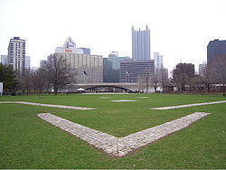
Point State Park is a Pennsylvania state park on 36 acres (145,687 m²) in Downtown Pittsburgh, Allegheny County
, Pennsylvania
, USA, at the confluence
of the Allegheny
and Monongahela
rivers, forming the Ohio River
.
Built on land acquired via eminent domain
from industrial enterprises in the 1950s, the park opened in August, 1974 http://www.postgazette.com/pg/11320/1190325-100.stm when construction was completed on its iconic fountain. Pittsburgh settled on the current design after rejecting an alternative plan for a Point Park Civic Center
designed by Frank Lloyd Wright
.
The park also includes the outlines and remains of two of the oldest structures in Pittsburgh, Fort Pitt
and Fort Duquesne
. The Fort Pitt Museum
, housed in the Monongahela Bastion
of Fort Pitt, commemorates the French and Indian War
(1754–1763), in which the area soon to become Pittsburgh was a major battlefield.
and Three Rivers Regatta
. The park, a registered National Historic Landmark
, is operated by the Pennsylvania Bureau of State Parks
.
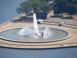 The fountain in Point State Park, which sprays water up to 150 feet (45.7 m) in the air at the head of the Ohio River
, draws upon water from an aquifer
that passes beneath the park known as the "Wisconsin Glacial Flow", an ancient river channel now filled with sand and gravel as a result of the Pleistocene glaciation and the consequent re-routing of Pittsburgh's rivers.
The location of the fountain at the tip of the Point previously served as a connector for two old bridges, the Manchester Bridge (over the Allegheny River) and Point Bridge (over the Monongahela). Both were removed in 1970 to make way for the fountain.
, announced a $25 million plan to renovate Point State Park on October 11, 2006. The plans call for improving the green spaces within the park, expanding recreational opportunities, preserving historical installations, and updating outdated amenities. The project is scheduled to be completed within four years, with the majority of the work to be completed in time for Pittsburgh's 250th anniversary celebration in 2008.
Sections of the park have fallen into disuse since it was established in the summer of 1974. The homeless have used the trenches surrounding the foundations of the remains of Fort Pitt as a temporary shelter for years. Graffiti
on the structures of the park has become a major problem. Sections of the park are littered with fence posts, cut logs, plastic drums, and rolled up snow drift fencing. The walkways have become cracked and are beginning to fall apart. The goal of the restoration project is to reestablish the park as a recreational destination.
Plans for improving the park include installing new pumps and pipes in the fountain, establishing a seating area around the fountain and a wading area for children, restoring the river walk with steps that lead into the river, building kiosks for information and concessions, renovating the rest rooms, renovating the water taxi
landings and surrounding docks, and installing wireless internet
access hubs.
These plans are not being put into place without some controversy. On January 25, 2007, 13 members of two local labor unions were arrested for blocking access by contractors to the work sites at the remnants of Fort Pitt. The unions were protesting the use of four nonrepresented workers by the contractor. In addition, advocates for historical preservation disagreed with the decision to bury the remnants of the fort's walls, which could damage the bricks and remove the walls from public access.
Point State Park was reopened to the public in the spring of 2008. The renovation process took a year and a half to complete.

 The confluence of the Allegheny and Monongahela rivers, creating the Ohio River, has greatly impacted the history of Point State Park. It was once at the center of river travel, trade, and even wars throughout the pioneer history of Western Pennsylvania
. During the mid-18th century, the armies of France
and the Great Britain
carved paths through the wilderness to control the point area and trade on the rivers. The French built Fort Duquesne
in 1754 on foundations of Fort Prince George
, which had been built by the colonial forces of Virginia
.
The French held Fort Duquesne during the French and Indian War
, and it became one of the focal points for that war because of its strategic riverside location in disputed territory. The French held the fort successfully early in the war, turning back the 1755 expedition led
by General Edward Braddock
. A smaller attack
by James Grant
in September 1758 was repulsed, but with heavy losses. Two months later, on November 25, the Forbes Expedition
, under General John Forbes
, captured the site after the French destroyed Fort Duquesne the day before. The British built a much larger fort on the site and named it Fort Pitt
.
The Forbes Expedition was successful where the Braddock expedition had failed because of the Treaty of Easton
, in which local American Indians
agreed to abandon their alliance with the French. American Indians, primarily Delawares
and Shawnee
, made this agreement with the understanding that the British military would leave the area after the war. The Indians wanted a trading post
on the spot, but they did not want a British army garrison. The British, however, built Fort Pitt on the site, naming it after William Pitt the Elder.
As a result, in 1763 local Delawares and Shawnees took part in Pontiac's Rebellion
, an effort to drive the British from the region. The Indians' siege of Fort Pitt
began on June 22, 1763, but the fort was too strong to be taken by force. During the siege the commander of Fort Pitt discussed giving Delaware emissaries blankets that had been exposed to smallpox in hopes of infecting the surrounding Indians and ending the siege, and may have done so. If the attempt was made it was probably unsuccessful, and on August 1, 1763, most of the Indians broke off the siege to intercept an approaching force under Colonel Henry Bouquet
, resulting in the Battle of Bushy Run
. Bouquet fought off the attack and relieved Fort Pitt on August 20.
After Pontiac's War, Fort Pitt was no longer necessary to the British Crown, and was abandoned to the locals in 1772. At that time, the Pittsburgh area was claimed by both Virginia and Pennsylvania, and a power struggle for the region commenced. Virginians took control of Fort Pitt, and for a brief while in the 1770s it was called Fort Dunmore, in honour of Virginia's Governor Lord Dunmore
. The fort was a staging ground in Dunmore's War
of 1774.
During the American Revolutionary War
, Fort Pitt was the headquarters for the western theatre of the war.
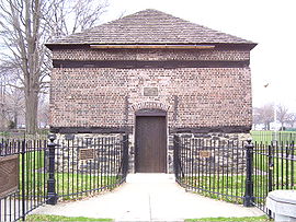
A small brick building called the Blockhouse
—actually an outbuilding known as a redoubt
—remains in Point State Park, the only intact remnant of Fort Pitt. It was erected in 1764, and is believed to be the oldest building, not only in Pittsburgh, but in Western Pennsylvania. Used for many years as a house, the blockhouse was purchased and has been preserved for many years by the Daughters of the American Revolution
, who open it to the public.
City leaders wanted to alleviate traffic congestion in the city. Two bridges met at the point in a way that left no room for the interchange required by the volume of traffic. The growth of the city had made parking a serious problem as well. Robert Moses
, who had developed the traffic scheme for New York City
, was brought in and published a traffic plan in 1939. He offered a circular park surrounded by approach roads connecting the bridges to the city. His plan retained the existing bridges, but most of the experts brought in to examine the problem called for the bridges to be relocated away from the Point, creating more space for adjoining access roads and interchanges.
Although the site had substantial problems, Robert Alberts observes that "the condition, in the view of the city planner, was almost perfect". The Point had few property owners who needed to be bought out, few residents who would need relocation, and few structures worth preserving. Architects and planners could treat it as a tabula rasa
.
During the course of the Second World War, federal and local authorities established three goals for the site: "the creation of a park commemorating the site's history, improved traffic circulation through the construction of new roads and bridges, and designation of a portion of the site for new office buildings, intended to stimulate private interest in the Golden Triangle". The Allegheny Conference on Community Development
became a driving force for these changes. Edgar Kaufmann, a Pittsburgh department store owner, sat on the board of the Conference and became chair of the 28-member committee convened to look into the Point Park problem.
Kaufmann wanted a plan for the Point that was more urban and developed than the park others were imagining. In particular, Kaufmann was a major supporter of Pittsburgh Civic Light Opera
and wanted to provide it with a permanent building. He brought in Wright, by that time a preeminent architect, who had done numerous other projects for Kaufmann in the past, including Kaufmann's landmark home at Fallingwater
and an unbuilt design for a parking garage.
Plans for Point Park Civic Center fell through and ultimately, the site was turned into a park with historic and recreational aspects, Point State Park. The Fort Pitt blockhouse remained intact, and three of the five bastions of the fort have been restored. The state acquired almost all property for the site by 1949, at a cost of $7,588,500 ($ in ); the park was finally completed in August, 1974. Areas adjoining the park were condemned to permit commercial development, most notably Gateway Center
.
Allegheny County, Pennsylvania
Allegheny County is a county in the southwestern part of the U.S. state of Pennsylvania. As of the 2010 census, the population was 1,223,348; making it the second most populous county in Pennsylvania, following Philadelphia County. The county seat is Pittsburgh...
, Pennsylvania
Pennsylvania
The Commonwealth of Pennsylvania is a U.S. state that is located in the Northeastern and Mid-Atlantic regions of the United States. The state borders Delaware and Maryland to the south, West Virginia to the southwest, Ohio to the west, New York and Ontario, Canada, to the north, and New Jersey to...
, USA, at the confluence
Confluence (geography)
In geography, a confluence is the meeting of two or more bodies of water. It usually refers to the point where two streams flow together, merging into a single stream...
of the Allegheny
Allegheny River
The Allegheny River is a principal tributary of the Ohio River; it is located in the Eastern United States. The Allegheny River joins with the Monongahela River to form the Ohio River at the "Point" of Point State Park in Downtown Pittsburgh, Pennsylvania...
and Monongahela
Monongahela River
The Monongahela River is a river on the Allegheny Plateau in north-central West Virginia and southwestern Pennsylvania in the United States...
rivers, forming the Ohio River
Ohio River
The Ohio River is the largest tributary, by volume, of the Mississippi River. At the confluence, the Ohio is even bigger than the Mississippi and, thus, is hydrologically the main stream of the whole river system, including the Allegheny River further upstream...
.
Built on land acquired via eminent domain
Eminent domain
Eminent domain , compulsory purchase , resumption/compulsory acquisition , or expropriation is an action of the state to seize a citizen's private property, expropriate property, or seize a citizen's rights in property with due monetary compensation, but without the owner's consent...
from industrial enterprises in the 1950s, the park opened in August, 1974 http://www.postgazette.com/pg/11320/1190325-100.stm when construction was completed on its iconic fountain. Pittsburgh settled on the current design after rejecting an alternative plan for a Point Park Civic Center
Point Park Civic Center
The Point Park Civic Center was a proposed civic center for downtown Pittsburgh, Pennsylvania, United States, where the confluence of the Allegheny and Monongahela Rivers forms the Ohio River. Frank Lloyd Wright designed the structure on a commission from Edgar J. Kaufmann in the late 1940s. Wright...
designed by Frank Lloyd Wright
Frank Lloyd Wright
Frank Lloyd Wright was an American architect, interior designer, writer and educator, who designed more than 1,000 structures and completed 500 works. Wright believed in designing structures which were in harmony with humanity and its environment, a philosophy he called organic architecture...
.
The park also includes the outlines and remains of two of the oldest structures in Pittsburgh, Fort Pitt
Fort Pitt (Pennsylvania)
Fort Pitt was a fort built at the location of Pittsburgh, Allegheny County, Pennsylvania.-French and Indian War:The fort was built from 1759 to 1761 during the French and Indian War , next to the site of former Fort Duquesne, at the confluence the Allegheny River and the Monongahela River...
and Fort Duquesne
Fort Duquesne
Fort Duquesne was a fort established by the French in 1754, at the junction of the Allegheny and Monongahela rivers in what is now downtown Pittsburgh in the state of Pennsylvania....
. The Fort Pitt Museum
Fort Pitt Museum
Fort Pitt Museum is an indoor/outdoor museum that is administiered by the Senator John Heinz History Center in downtown Pittsburgh, Allegheny County, Pennsylvania in the United States. It is at the confluence of the Monongahela and Allegheny Rivers, where the Ohio River is formed...
, housed in the Monongahela Bastion
Bastion
A bastion, or a bulwark, is a structure projecting outward from the main enclosure of a fortification, situated in both corners of a straight wall , facilitating active defence against assaulting troops...
of Fort Pitt, commemorates the French and Indian War
French and Indian War
The French and Indian War is the common American name for the war between Great Britain and France in North America from 1754 to 1763. In 1756, the war erupted into the world-wide conflict known as the Seven Years' War and thus came to be regarded as the North American theater of that war...
(1754–1763), in which the area soon to become Pittsburgh was a major battlefield.
Recreation
Today the park provides recreational space for workers, visitors, and residents in downtown Pittsburgh and also acts as the site for major cultural events in the city, including the Venture Outdoors Festival, Three Rivers Arts FestivalThree Rivers Arts Festival
Three Rivers Arts Festival is a large outdoor festival of the visual and performing arts held every summer throughout downtown Pittsburgh, Pennsylvania.The festival has been held annually, in June, since 1959....
and Three Rivers Regatta
Pittsburgh Three Rivers Regatta
The Pittsburgh Three Rivers Regatta is an annual motorboat and river festival held in Pittsburgh, Pennsylvania, United States. The festival was founded in 1977 and is often host to an F1 ChampBoat Series race. The F1 race, originally held in 1982, was the first F1 power boat race held in the...
. The park, a registered National Historic Landmark
National Historic Landmark
A National Historic Landmark is a building, site, structure, object, or district, that is officially recognized by the United States government for its historical significance...
, is operated by the Pennsylvania Bureau of State Parks
Pennsylvania Bureau of State Parks
The Pennsylvania Bureau of State Parks is an agency of the U.S. state of Pennsylvania that manages and operates the state park system of the state. The agency is part of the Pennsylvania Department of Conservation and Natural Resources .-External links:...
.
The Fountain
Ohio River
The Ohio River is the largest tributary, by volume, of the Mississippi River. At the confluence, the Ohio is even bigger than the Mississippi and, thus, is hydrologically the main stream of the whole river system, including the Allegheny River further upstream...
, draws upon water from an aquifer
Aquifer
An aquifer is a wet underground layer of water-bearing permeable rock or unconsolidated materials from which groundwater can be usefully extracted using a water well. The study of water flow in aquifers and the characterization of aquifers is called hydrogeology...
that passes beneath the park known as the "Wisconsin Glacial Flow", an ancient river channel now filled with sand and gravel as a result of the Pleistocene glaciation and the consequent re-routing of Pittsburgh's rivers.
The location of the fountain at the tip of the Point previously served as a connector for two old bridges, the Manchester Bridge (over the Allegheny River) and Point Bridge (over the Monongahela). Both were removed in 1970 to make way for the fountain.
Renovations
Michael DeBerardinis, Secretary of the Pennsylvania Department of Conservation and Natural ResourcesPennsylvania Department of Conservation and Natural Resources
The Pennsylvania Department of Conservation and Natural Resources , established on July 1, 1995, is the agency in the U.S. State of Pennsylvania responsible for maintaining and preserving the state's 117 state parks and 20 state forests; providing information on the state's natural resources; and...
, announced a $25 million plan to renovate Point State Park on October 11, 2006. The plans call for improving the green spaces within the park, expanding recreational opportunities, preserving historical installations, and updating outdated amenities. The project is scheduled to be completed within four years, with the majority of the work to be completed in time for Pittsburgh's 250th anniversary celebration in 2008.
Sections of the park have fallen into disuse since it was established in the summer of 1974. The homeless have used the trenches surrounding the foundations of the remains of Fort Pitt as a temporary shelter for years. Graffiti
Graffiti
Graffiti is the name for images or lettering scratched, scrawled, painted or marked in any manner on property....
on the structures of the park has become a major problem. Sections of the park are littered with fence posts, cut logs, plastic drums, and rolled up snow drift fencing. The walkways have become cracked and are beginning to fall apart. The goal of the restoration project is to reestablish the park as a recreational destination.
Plans for improving the park include installing new pumps and pipes in the fountain, establishing a seating area around the fountain and a wading area for children, restoring the river walk with steps that lead into the river, building kiosks for information and concessions, renovating the rest rooms, renovating the water taxi
Water taxi
A water taxi or water bus, also known as a commuter boat, is a watercraft used to provide public transport, usually but not always in an urban environment. Service may be scheduled with multiple stops, operating in a similar manner to a bus, or on demand to many locations, operating in a similar...
landings and surrounding docks, and installing wireless internet
Internet
The Internet is a global system of interconnected computer networks that use the standard Internet protocol suite to serve billions of users worldwide...
access hubs.
These plans are not being put into place without some controversy. On January 25, 2007, 13 members of two local labor unions were arrested for blocking access by contractors to the work sites at the remnants of Fort Pitt. The unions were protesting the use of four nonrepresented workers by the contractor. In addition, advocates for historical preservation disagreed with the decision to bury the remnants of the fort's walls, which could damage the bricks and remove the walls from public access.
Point State Park was reopened to the public in the spring of 2008. The renovation process took a year and a half to complete.
French and Indian War
Western Pennsylvania
Western Pennsylvania consists of the western third of the state of Pennsylvania in the United States. Pittsburgh is the largest city in the region, with a metropolitan area population of about 2.4 million people, and serves as its economic and cultural center. Erie, Altoona, and Johnstown are its...
. During the mid-18th century, the armies of France
New France
New France was the area colonized by France in North America during a period beginning with the exploration of the Saint Lawrence River by Jacques Cartier in 1534 and ending with the cession of New France to Spain and Great Britain in 1763...
and the Great Britain
Thirteen Colonies
The Thirteen Colonies were English and later British colonies established on the Atlantic coast of North America between 1607 and 1733. They declared their independence in the American Revolution and formed the United States of America...
carved paths through the wilderness to control the point area and trade on the rivers. The French built Fort Duquesne
Fort Duquesne
Fort Duquesne was a fort established by the French in 1754, at the junction of the Allegheny and Monongahela rivers in what is now downtown Pittsburgh in the state of Pennsylvania....
in 1754 on foundations of Fort Prince George
Fort Prince George
Fort Prince George was an uncompleted fort on what is now the site of Pittsburgh, at the confluence of the Allegheny and Monongahela Rivers in Allegheny County, Pennsylvania. The site was originally a trading post established by Ohio Company trader William Trent in the 1740s...
, which had been built by the colonial forces of Virginia
Virginia
The Commonwealth of Virginia , is a U.S. state on the Atlantic Coast of the Southern United States. Virginia is nicknamed the "Old Dominion" and sometimes the "Mother of Presidents" after the eight U.S. presidents born there...
.
The French held Fort Duquesne during the French and Indian War
French and Indian War
The French and Indian War is the common American name for the war between Great Britain and France in North America from 1754 to 1763. In 1756, the war erupted into the world-wide conflict known as the Seven Years' War and thus came to be regarded as the North American theater of that war...
, and it became one of the focal points for that war because of its strategic riverside location in disputed territory. The French held the fort successfully early in the war, turning back the 1755 expedition led
Braddock expedition
The Braddock expedition, also called Braddock's campaign or, more commonly, Braddock's Defeat, was a failed British military expedition which attempted to capture the French Fort Duquesne in the summer of 1755 during the French and Indian War. It was defeated at the Battle of the Monongahela on...
by General Edward Braddock
Edward Braddock
General Edward Braddock was a British soldier and commander-in-chief for the 13 colonies during the actions at the start of the French and Indian War...
. A smaller attack
Battle of Fort Duquesne
The Battle of Fort Duquesne was a British assault on the eponymous French fort that was repulsed with heavy losses on 14 September 1758, during the French and Indian War....
by James Grant
James Grant (general)
James Grant, Laird of Ballindalloch was a major general in the British Army during the American War of Independence. He served as Governor of East Florida from 1763 to 1771.-Early career:...
in September 1758 was repulsed, but with heavy losses. Two months later, on November 25, the Forbes Expedition
Forbes Expedition
The Forbes Expedition was a British military expedition led by Brigadier-General John Forbes in 1758, during the French and Indian War. Its objective was the capture of Fort Duquesne, a French fort constructed at the confluence of the Allegheny and Monongahela Rivers in 1754.The expedition...
, under General John Forbes
John Forbes (General)
John Forbes was a British general in the French and Indian War. He is best known for leading the Forbes Expedition that captured the French outpost at Fort Duquesne and for naming the city of Pittsburgh, Pennsylvania after British Secretary of State William Pitt the Elder.-Early life:Forbes was...
, captured the site after the French destroyed Fort Duquesne the day before. The British built a much larger fort on the site and named it Fort Pitt
Fort Pitt (Pennsylvania)
Fort Pitt was a fort built at the location of Pittsburgh, Allegheny County, Pennsylvania.-French and Indian War:The fort was built from 1759 to 1761 during the French and Indian War , next to the site of former Fort Duquesne, at the confluence the Allegheny River and the Monongahela River...
.
The Forbes Expedition was successful where the Braddock expedition had failed because of the Treaty of Easton
Treaty of Easton
The Treaty of Easton was a colonial agreement in North America signed in October 1758 during the French and Indian War . Briefly, chiefs of 13 Native American nations, representing tribes of the Iroquois, Lenape-Delaware, Shawnee and others, agreed to be allies of the British colonies during the...
, in which local American Indians
Native Americans in the United States
Native Americans in the United States are the indigenous peoples in North America within the boundaries of the present-day continental United States, parts of Alaska, and the island state of Hawaii. They are composed of numerous, distinct tribes, states, and ethnic groups, many of which survive as...
agreed to abandon their alliance with the French. American Indians, primarily Delawares
Lenape
The Lenape are an Algonquian group of Native Americans of the Northeastern Woodlands. They are also called Delaware Indians. As a result of the American Revolutionary War and later Indian removals from the eastern United States, today the main groups live in Canada, where they are enrolled in the...
and Shawnee
Shawnee
The Shawnee, Shaawanwaki, Shaawanooki and Shaawanowi lenaweeki, are an Algonquian-speaking people native to North America. Historically they inhabited the areas of Ohio, Virginia, West Virginia, Western Maryland, Kentucky, Indiana, and Pennsylvania...
, made this agreement with the understanding that the British military would leave the area after the war. The Indians wanted a trading post
Trading post
A trading post was a place or establishment in historic Northern America where the trading of goods took place. The preferred travel route to a trading post or between trading posts, was known as a trade route....
on the spot, but they did not want a British army garrison. The British, however, built Fort Pitt on the site, naming it after William Pitt the Elder.
As a result, in 1763 local Delawares and Shawnees took part in Pontiac's Rebellion
Pontiac's Rebellion
Pontiac's War, Pontiac's Conspiracy, or Pontiac's Rebellion was a war that was launched in 1763 by a loose confederation of elements of Native American tribes primarily from the Great Lakes region, the Illinois Country, and Ohio Country who were dissatisfied with British postwar policies in the...
, an effort to drive the British from the region. The Indians' siege of Fort Pitt
Siege of Fort Pitt
The Siege of Fort Pitt took place in 1763 in what is now the city of Pittsburgh, Pennsylvania, United States. The siege was a part of Pontiac's Rebellion, an effort by American Indians to drive the British out of the Ohio Country and back across the Appalachian Mountains...
began on June 22, 1763, but the fort was too strong to be taken by force. During the siege the commander of Fort Pitt discussed giving Delaware emissaries blankets that had been exposed to smallpox in hopes of infecting the surrounding Indians and ending the siege, and may have done so. If the attempt was made it was probably unsuccessful, and on August 1, 1763, most of the Indians broke off the siege to intercept an approaching force under Colonel Henry Bouquet
Henry Bouquet
Henry Bouquet was a prominent British Army officer in the French and Indian War and Pontiac's War. Bouquet is best known for his victory over Native Americans at the Battle of Bushy Run, lifting the siege of Fort Pitt during Pontiac's War.-Early life:Bouquet was born into a moderately wealthy...
, resulting in the Battle of Bushy Run
Battle of Bushy Run
The Battle of Bushy Run was fought on August 5-6, 1763, in western Pennsylvania, between a British column under the command of Colonel Henry Bouquet and a combined force of Delaware, Shawnee, Mingo, and Huron warriors. This action occurred during Pontiac's Rebellion...
. Bouquet fought off the attack and relieved Fort Pitt on August 20.
After Pontiac's War, Fort Pitt was no longer necessary to the British Crown, and was abandoned to the locals in 1772. At that time, the Pittsburgh area was claimed by both Virginia and Pennsylvania, and a power struggle for the region commenced. Virginians took control of Fort Pitt, and for a brief while in the 1770s it was called Fort Dunmore, in honour of Virginia's Governor Lord Dunmore
John Murray, 4th Earl of Dunmore
John Murray, 4th Earl of Dunmore was a British peer and colonial governor. He was the son of William Murray, 3rd Earl of Dunmore, and his wife Catherine . He is best remembered as the last royal governor of the Colony of Virginia.John was the eldest son of William and Catherine Murray, and nephew...
. The fort was a staging ground in Dunmore's War
Dunmore's War
Dunmore's War was a war in 1774 between the Colony of Virginia and the Shawnee and Mingo American Indian nations....
of 1774.
During the American Revolutionary War
American Revolutionary War
The American Revolutionary War , the American War of Independence, or simply the Revolutionary War, began as a war between the Kingdom of Great Britain and thirteen British colonies in North America, and ended in a global war between several European great powers.The war was the result of the...
, Fort Pitt was the headquarters for the western theatre of the war.
A small brick building called the Blockhouse
Fort Pitt Blockhouse
The Fort Pitt Blockhouse is a historic building in Point State Park in the city of Pittsburgh...
—actually an outbuilding known as a redoubt
Redoubt
A redoubt is a fort or fort system usually consisting of an enclosed defensive emplacement outside a larger fort, usually relying on earthworks, though others are constructed of stone or brick. It is meant to protect soldiers outside the main defensive line and can be a permanent structure or a...
—remains in Point State Park, the only intact remnant of Fort Pitt. It was erected in 1764, and is believed to be the oldest building, not only in Pittsburgh, but in Western Pennsylvania. Used for many years as a house, the blockhouse was purchased and has been preserved for many years by the Daughters of the American Revolution
Daughters of the American Revolution
The Daughters of the American Revolution is a lineage-based membership organization for women who are descended from a person involved in United States' independence....
, who open it to the public.
Redevelopment
During the city's early history, the Point became a hub for industry and transportation. By the 1930s it was occupied by warehouses and railroad yards. Wright commented in 1935 that the city had wasted the potential of its rivers and hilly landscape. In 1945, the situation in this regard was even worse; four years of World War II and eight years of the Great Depression had permitted urban blight to make substantial inroads. The total assessed property value in the Golden Triangle was at a record low and falling. At the point, rarely-used railroad facilities included 15 acres (60,702.9 m²) of yards (60000 m2) and half a mile (800 m) of elevated train tracks.City leaders wanted to alleviate traffic congestion in the city. Two bridges met at the point in a way that left no room for the interchange required by the volume of traffic. The growth of the city had made parking a serious problem as well. Robert Moses
Robert Moses
Robert Moses was the "master builder" of mid-20th century New York City, Long Island, Rockland County, and Westchester County, New York. As the shaper of a modern city, he is sometimes compared to Baron Haussmann of Second Empire Paris, and is one of the most polarizing figures in the history of...
, who had developed the traffic scheme for New York City
New York City
New York is the most populous city in the United States and the center of the New York Metropolitan Area, one of the most populous metropolitan areas in the world. New York exerts a significant impact upon global commerce, finance, media, art, fashion, research, technology, education, and...
, was brought in and published a traffic plan in 1939. He offered a circular park surrounded by approach roads connecting the bridges to the city. His plan retained the existing bridges, but most of the experts brought in to examine the problem called for the bridges to be relocated away from the Point, creating more space for adjoining access roads and interchanges.
Although the site had substantial problems, Robert Alberts observes that "the condition, in the view of the city planner, was almost perfect". The Point had few property owners who needed to be bought out, few residents who would need relocation, and few structures worth preserving. Architects and planners could treat it as a tabula rasa
Tabula rasa
Tabula rasa is the epistemological theory that individuals are born without built-in mental content and that their knowledge comes from experience and perception. Generally proponents of the tabula rasa thesis favour the "nurture" side of the nature versus nurture debate, when it comes to aspects...
.
During the course of the Second World War, federal and local authorities established three goals for the site: "the creation of a park commemorating the site's history, improved traffic circulation through the construction of new roads and bridges, and designation of a portion of the site for new office buildings, intended to stimulate private interest in the Golden Triangle". The Allegheny Conference on Community Development
Allegheny Conference
The Allegheny Conference on Community Development is an nonprofit, private sector leadership organization dedicated to economic development and quality of life issues for the greater Pittsburgh region, Pennsylvania, United States....
became a driving force for these changes. Edgar Kaufmann, a Pittsburgh department store owner, sat on the board of the Conference and became chair of the 28-member committee convened to look into the Point Park problem.
Kaufmann wanted a plan for the Point that was more urban and developed than the park others were imagining. In particular, Kaufmann was a major supporter of Pittsburgh Civic Light Opera
Pittsburgh Civic Light Opera
Pittsburgh Civic Light Opera is a nonprofit professional theater company based in the Cultural District of Downtown Pittsburgh, Pennsylvania, USA....
and wanted to provide it with a permanent building. He brought in Wright, by that time a preeminent architect, who had done numerous other projects for Kaufmann in the past, including Kaufmann's landmark home at Fallingwater
Fallingwater
Fallingwater or Kaufmann Residence is a house designed by architect Frank Lloyd Wright in 1935 in rural southwestern Pennsylvania, 50 miles southeast of Pittsburgh...
and an unbuilt design for a parking garage.
Plans for Point Park Civic Center fell through and ultimately, the site was turned into a park with historic and recreational aspects, Point State Park. The Fort Pitt blockhouse remained intact, and three of the five bastions of the fort have been restored. The state acquired almost all property for the site by 1949, at a cost of $7,588,500 ($ in ); the park was finally completed in August, 1974. Areas adjoining the park were condemned to permit commercial development, most notably Gateway Center
Gateway Center (Pittsburgh)
The Gateway Center in Pittsburgh, Pennsylvania is a high-rise building complex with of office space in four buildings. Gateway Center was purchased in 2004 by Hertz Investment Group, a Los Angeles, California based real estate investment company, for US$55 million...
.
Nearby state parks
The following state parks are within 30 miles (48.3 km) of Point State Park:- Allegheny Islands State ParkAllegheny Islands State ParkAllegheny Islands State Park is a Pennsylvania state park in Harmar Township, Allegheny County, Pennsylvania in the United States. The undeveloped park is composed of three alluvial islands located in the middle of the Allegheny River northeast of Pittsburgh. The islands are just north of the...
(Allegheny County) - Hillman State ParkHillman State ParkHillman State Park is a Pennsylvania state park in Hanover Township, Washington County in the United States. It is about west of Pittsburgh. The park opened in the late 1960s and has been managed for hunting by the Pennsylvania Game Commission since the early 1980s. The park also has hiking,...
(Washington CountyWashington County, Pennsylvania-Government and politics:As of November 2008, there are 152,534 registered voters in Washington County .* Democratic: 89,027 * Republican: 49,025 * Other Parties: 14,482...
) - Raccoon Creek State ParkRaccoon Creek State ParkRaccoon Creek State Park is a Pennsylvania state park on Raccoon Creek in Hanover and Independence townships in Beaver County, Pennsylvania in the United States. The park is about from the city of Pittsburgh, near Hookstown. Raccoon Creek State Park is easily accessed from Pennsylvania Route 18...
(Beaver CountyBeaver County, Pennsylvania-Demographics:As of the census of 2000, there were 181,412 people, 72,576 households, and 50,512 families residing in the county. The population density was 418 people per square mile . There were 77,765 housing units at an average density of 179 per square mile...
)