
9 de Julio Avenue
Encyclopedia
Avenida 9 de Julio is a wide avenue in the city of Buenos Aires
, Argentina
. Its name honors Argentina's Independence Day
, July 9, 1816.
The avenue runs roughly one kilometer to the west of the Río de la Plata
waterfront, from the Retiro
district in the north to Constitución station in the south. The avenue has up to seven lanes in each direction and is flanked on either side by streets with an additional four lanes.
The northern end of the avenue is connected to the Arturo Illia expressway (which connects to Jorge Newbery airport
and the Pan-American highway
) and to Libertador avenue. The southern end is connected to the 25 de Mayo tollway (serving the West side of Greater Buenos Aires as well as Ezeiza airport
) and the 9 de Julio elevated expressway which provides access to the two main southbound roads out of the city (route 1 to La Plata
and route 2 to Mar del Plata
).
, the distance between two streets in the checkerboard pattern used in Buenos Aires. The distance between adjacent streets is roughly 110 meters, greater than the equivalent distance in Manhattan
, New York
, USA. The street flanking 9 de Julio to the east is called Carlos Pellegrini (north of Rivadavia) and Bernardo de Irigoyen (south of Rivadavia). The street flanking 9 de Julio to the west is called Cerrito (north of Rivadavia) and Lima (south of Rivadavia).
The avenue was first planned in 1888 with the name of Ayohuma; but, long opposed by affected landlords and residents, work did not start until 1935. The initial phase was inaugurated on 9 July 1937 and the main stretch of the avenue was completed in the 1960s. The southern connections were completed after 1980, when the downtown portion of the tollway system was completed. Clearing the right-of-way for these intersections required massive condemnations
in the Constitución area.
Line C
of the Buenos Aires Metro
runs for a stretch under the avenue. Line A
, Line B
, Line D
, and Line E
have stations when their course intersects the avenue. Notably, lines B, C, and D share a station underneath the Obelisk, which is the focal point of the subway system and features a retail concourse which also serves as an underpass. The respective station names are Carlos Pellegrini, Diagonal Norte, and 9 de Julio.
Crossing the avenue at street level often requires a few minutes, as all intersections have traffic lights. Under normal walking speed, it takes pedestrians normally two to three green lights to cross it. Some urban planners have submitted projects to move the central part of the avenue underground, to alleviate the perceived "chasm" between the two sides of the avenue.
Avenida 9 de Julio
Buenos Aires
Buenos Aires is the capital and largest city of Argentina, and the second-largest metropolitan area in South America, after São Paulo. It is located on the western shore of the estuary of the Río de la Plata, on the southeastern coast of the South American continent...
, Argentina
Argentina
Argentina , officially the Argentine Republic , is the second largest country in South America by land area, after Brazil. It is constituted as a federation of 23 provinces and an autonomous city, Buenos Aires...
. Its name honors Argentina's Independence Day
Argentine Declaration of Independence
What today is commonly referred as the Independence of Argentina was declared on July 9, 1816 by the Congress of Tucumán. In reality, the congressmen that were assembled in Tucumán declared the independence of the United Provinces of South America, which is still today one of the legal names of the...
, July 9, 1816.
The avenue runs roughly one kilometer to the west of the Río de la Plata
Río de la Plata
The Río de la Plata —sometimes rendered River Plate in British English and the Commonwealth, and occasionally rendered [La] Plata River in other English-speaking countries—is the river and estuary formed by the confluence of the Uruguay River and the Paraná River on the border between Argentina and...
waterfront, from the Retiro
Retiro, Buenos Aires
Retiro is a barrio in Buenos Aires, Argentina. Located in the northeast end of the city, Retiro is bordered on the south by the Puerto Madero and San Nicolás wards, and on the west by the Recoleta ward.-Urban character:...
district in the north to Constitución station in the south. The avenue has up to seven lanes in each direction and is flanked on either side by streets with an additional four lanes.
The northern end of the avenue is connected to the Arturo Illia expressway (which connects to Jorge Newbery airport
Aeroparque Jorge Newbery
-Accidents and incidents:*On 17 December 1969, an Austral Líneas Aéreas C-46 Commando, lost engine 1 due to fuel exhaustion shortly after take-off. The plane failed to gain height and made a crash landing in a small sport field...
and the Pan-American highway
Pan-American Highway
The Pan-American Highway is a network of roads measuring about in total length. Except for an rainforest break, called the Darién Gap, the road links the mainland nations of the Americas in a connected highway system. According to Guinness World Records, the Pan-American Highway is the world's...
) and to Libertador avenue. The southern end is connected to the 25 de Mayo tollway (serving the West side of Greater Buenos Aires as well as Ezeiza airport
Ministro Pistarini International Airport
Ministro Pistarini International Airport , more commonly known as Ezeiza International Airport owing to its location within the Ezeiza Partido in the Greater Buenos Aires, is an international airport located south-southwest of Buenos Aires, the capital city of Argentina...
) and the 9 de Julio elevated expressway which provides access to the two main southbound roads out of the city (route 1 to La Plata
La Plata
La Plata is the capital city of the Province of Buenos Aires, Argentina, and of La Plata partido. According to the , the city proper has a population of 574,369 and its metropolitan area has 694,253 inhabitants....
and route 2 to Mar del Plata
Mar del Plata
Mar del Plata is an Argentine city located on the coast of the Atlantic Ocean, south of Buenos Aires. Mar del Plata is the second largest city of Buenos Aires Province. The name "Mar del Plata" had apparently the sense of "sea of the Río de la Plata region" or "adjoining sea to the Río de la Plata"...
).
History and overview
The avenue's unusual width is because it spans an entire city blockCity block
A city block, urban block or simply block is a central element of urban planning and urban design. A city block is the smallest area that is surrounded by streets. City blocks are the space for buildings within the street pattern of a city, they form the basic unit of a city's urban fabric...
, the distance between two streets in the checkerboard pattern used in Buenos Aires. The distance between adjacent streets is roughly 110 meters, greater than the equivalent distance in Manhattan
Manhattan
Manhattan is the oldest and the most densely populated of the five boroughs of New York City. Located primarily on the island of Manhattan at the mouth of the Hudson River, the boundaries of the borough are identical to those of New York County, an original county of the state of New York...
, New York
New York
New York is a state in the Northeastern region of the United States. It is the nation's third most populous state. New York is bordered by New Jersey and Pennsylvania to the south, and by Connecticut, Massachusetts and Vermont to the east...
, USA. The street flanking 9 de Julio to the east is called Carlos Pellegrini (north of Rivadavia) and Bernardo de Irigoyen (south of Rivadavia). The street flanking 9 de Julio to the west is called Cerrito (north of Rivadavia) and Lima (south of Rivadavia).
The avenue was first planned in 1888 with the name of Ayohuma; but, long opposed by affected landlords and residents, work did not start until 1935. The initial phase was inaugurated on 9 July 1937 and the main stretch of the avenue was completed in the 1960s. The southern connections were completed after 1980, when the downtown portion of the tollway system was completed. Clearing the right-of-way for these intersections required massive condemnations
Eminent domain
Eminent domain , compulsory purchase , resumption/compulsory acquisition , or expropriation is an action of the state to seize a citizen's private property, expropriate property, or seize a citizen's rights in property with due monetary compensation, but without the owner's consent...
in the Constitución area.
Line C
Line C (Buenos Aires)
Line C of the Buenos Aires Metro that runs from Retiro to Constitución terminus, opened on 9 November 1934, and it has a length of 4.3 km.-Stations and connections:-Murals:...
of the Buenos Aires Metro
Buenos Aires Metro
The Buenos Aires Metro , locally known as Subte is a mass-transit system that serves the city of Buenos Aires, Argentina. The first station of this network opened in 1913, the first of its kind in South America, the Southern Hemisphere and the entire Spanish-speaking world...
runs for a stretch under the avenue. Line A
Line A (Buenos Aires)
Line A is the oldest line of the Buenos Aires Metro. This historic line runs from Plaza de Mayo to Carabobo, and is scheduled to be extended towards San Pedrito station....
, Line B
Line B (Buenos Aires)
Line B of the Buenos Aires Metro runs from Leandro N. Alem to Los Incas/Parque Chas . Line B opened to the public on 17 October 1930....
, Line D
Line D (Buenos Aires)
Line D of the Buenos Aires Metro runs from Catedral to Congreso de Tucumán. The D Line opened on 3 June 1937 and has been expanded to the north several times. The line is currently 10.41 km long and runs approximately parallel to the city's coastline....
, and Line E
Line E (Buenos Aires)
Line E of the Buenos Aires Metro, which runs from Plaza de los Virreyes to Bolivar , opened on 20 June 1944, currently extends a total distance of 9.2 km.- External links :* * * *...
have stations when their course intersects the avenue. Notably, lines B, C, and D share a station underneath the Obelisk, which is the focal point of the subway system and features a retail concourse which also serves as an underpass. The respective station names are Carlos Pellegrini, Diagonal Norte, and 9 de Julio.
Crossing the avenue at street level often requires a few minutes, as all intersections have traffic lights. Under normal walking speed, it takes pedestrians normally two to three green lights to cross it. Some urban planners have submitted projects to move the central part of the avenue underground, to alleviate the perceived "chasm" between the two sides of the avenue.
Points of Interest
The main landmarks along the avenue are, north to south:- French Embassy: The FrenchFranceThe French Republic , The French Republic , The French Republic , (commonly known as France , is a unitary semi-presidential republic in Western Europe with several overseas territories and islands located on other continents and in the Indian, Pacific, and Atlantic oceans. Metropolitan France...
government refused to submit the embassy building for demolition, and local preservationists opposed the move as well, as the building is widely hailed as an architectural masterpiece. See [www.embafrancia -argentina.org their site] for detail. - Teatro Colón
- The western end of Lavalle Street, a pedestrianized street formerly known for its many cinemas
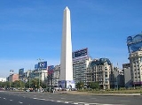
- The ObeliskObelisk of Buenos AiresThe Obelisk of Buenos Aires is a national historic monument and icon of Buenos Aires. Located in the Plaza de la República, in the intersection of avenues Corrientes and 9 de Julio, it was built to commemorate the fourth centenary of the first foundation of the city.In order to enrich the...
and Plaza de la RepúblicaPlaza de la República (Buenos Aires)Plaza de la República is a vast city square in Buenos Aires, capital of Argentina. It is located in the San Nicolás quarter, at the intersection of the city's three main arteries : Ninth of July Avenue, Corrientes Avenue, and Diagonal Norte... - Statue of Don Quixote in the intersection with Avenida de MayoAvenida de MayoAvenida de Mayo , is an avenue in Buenos Aires, capital of Argentina. It connects the Plaza de Mayo with Congressional Plaza, and extends in a west-east direction before merging into Avenida Rivadavia.-History and overview:...
- The former Ministry of Communications building (the only building sitting on the avenue itself), at the intersection with Moreno street.
- Constitución station and Plaza Constitución