

99 B-Line
Encyclopedia
The 99 B-Line is a bus rapid transit
line in Metro Vancouver, British Columbia
, Canada
. It travels along Broadway
, a major east-west thoroughfare, and connects the University of British Columbia
(UBC) to Commercial–Broadway Station
on the SkyTrain
system. It is operated by Coast Mountain Bus Company
and funded by TransLink.
It is the first and the most popular of the B-Line routes in the regional system. The other B-Lines that followed are based on the 99 B-Line in terms of the use of articulated buses (which can carry 120 passengers) and frequent arrivals for buses. The waiting time for a bus during peak hours on a weekday is 2–4 minutes. Most of the buses on this route are built by New Flyer Industries
of Winnipeg
, Manitoba
. On average it takes 42 minutes to complete the entire route, half an hour near the last runs at the end of the night.
As of 2010, the route is the busiest bus route in North America, with a ridership of over 50,000 passengers per day. This number is up from approximately 45,000 passengers per day in 2007.
in Burnaby via 10th Avenue, Broadway
and Lougheed Highway. Then under the jurisdiction of BC Transit
, it was launched in September 1996 and started out using a few high-floor articulated bus
es and regular-sized buses, but it was soon apparent that the regular buses could not handle the demand as this route soon became the most popular route in the system. 60-foot low-floor articulated buses were soon introduced in the summer of 1998, dedicated to this route and with a distinctive B-Line paint scheme. During rush hours, the B-Line uses curb lanes designated as bus lanes on Broadway from Commercial–Broadway Station
to Arbutus Street.
To get a sense of what a success this route was, an estimated total of 12,000 passengers per day used the route daily during its first two years of operation, 30% higher than originally estimated. Of that number, 20% of the passengers used to drive to their destination rather than take public transit. Service had to be extended to late-nights, Sundays and holidays.
Services levels were initially 10-minute headway
between UBC and Broadway Station, 10-20 minute headway between UBC and Brentwood Mall
, and 30 minute headway between UBC and Lougheed Mall. Increased demand saw a corresponding increase in frequency, but only in the UBC to Broadway Station section, with 7.5 minute headway. Soon the Lougheed Mall section was improved to 15 minute headway. Today the 99 B-Line operates on a 2 minute headway in the AM peak direction, with a 4.5 minute day base headway.
In the late 1990s, the British Columbia government approved a new SkyTrain line to be built, called the Millennium Line
. This new line replaced the eastern portion of the 99 B-Line, from Broadway Station to its old terminus at Lougheed Mall. It opened in 2002, with the 99 B-Line now terminating at Commercial–Broadway Station (combined Broadway Station of the Expo Line and Commercial Drive Station of the Millennium Line).
As the fair bulk of the route's riders are students at UBC, the introduction of the U-Pass
in 2003, a discounted bus pass for university students, put even more strain on the route's resources. A peak-hour
B-Line route called the #99 Special was introduced in 2004, featuring non-stop service to UBC during the morning rush hours and to Broadway Station during evening rush hours. This route's "non-stop" moniker was revoked in 2005 to supply more stops along the corridor, and was discontinued completely in January 2006 to make way for a new route that is about as fast as the #99 Special, the #84, which operates from UBC to the new VCC–Clark Station. This new route is supposed to take some pressure off the 99 B-Line. Additionally, curb lanes on Broadway have been converted into bus lanes for rush-hour periods.
On June 25, 2007, the 99 B-Line route became the first route in the TransLink system to allow passengers with valid proof of payment to board using any of the three doors at any stop. To facilitate this, the bus driver controls the operation of all three doors at each of the stops. Passengers who are paying cash or validating FareSavers must board through the front door. Fare Enforcement is carried out by Transit Security Officers. Transit Security Officers may board the bus at anytime to conduct a Fare Inspection. Passengers without valid fare could be removed from the bus or fined.
With the new Canada Line
, it is likely that the Millennium Line will be extended to meet the Canada Line's Broadway – City Hall Station at the intersection of Cambie Street and Broadway. If this happens, it is probable that the 99 B-Line's eastern terminus will be moved to this new station. There have also been talks about extending the Millennium Line all the way to UBC in the future, effectively replacing the 99 B-Line.
|}
Bus rapid transit
Bus rapid transit is a term applied to a variety of public transportation systems using buses to provide faster, more efficient service than an ordinary bus line. Often this is achieved by making improvements to existing infrastructure, vehicles and scheduling...
line in Metro Vancouver, British Columbia
British Columbia
British Columbia is the westernmost of Canada's provinces and is known for its natural beauty, as reflected in its Latin motto, Splendor sine occasu . Its name was chosen by Queen Victoria in 1858...
, Canada
Canada
Canada is a North American country consisting of ten provinces and three territories. Located in the northern part of the continent, it extends from the Atlantic Ocean in the east to the Pacific Ocean in the west, and northward into the Arctic Ocean...
. It travels along Broadway
Broadway (Vancouver)
Broadway is a major east-west thoroughfare in the city of Vancouver, British Columbia, Canada. In Vancouver's numbered avenue grid system, it runs in place of a 9th Avenue, between 8th and 10th. The street has four lanes for most of its course...
, a major east-west thoroughfare, and connects the University of British Columbia
University of British Columbia
The University of British Columbia is a public research university. UBC’s two main campuses are situated in Vancouver and in Kelowna in the Okanagan Valley...
(UBC) to Commercial–Broadway Station
Commercial–Broadway Station
Commercial–Broadway Station is located on an elevated portion of the Expo Line and Millenium Line and an at-grade portion of the Millennium Line, a part of Metro Vancouver's SkyTrain rapid transit system...
on the SkyTrain
SkyTrain (Vancouver)
SkyTrain is a light rapid transit system in Metro Vancouver, British Columbia, Canada. SkyTrain has of track and uses fully automated trains on grade-separated tracks, running mostly on elevated guideways, which helps SkyTrain to hold consistently high on-time reliability...
system. It is operated by Coast Mountain Bus Company
Coast Mountain Bus Company
Coast Mountain Bus Company is the contract operator for bus transit services in Metro Vancouver and is a wholly owned subsidiary of the South Coast British Columbia Transportation Authority known locally as TransLink, the entity responsible for transit...
and funded by TransLink.
It is the first and the most popular of the B-Line routes in the regional system. The other B-Lines that followed are based on the 99 B-Line in terms of the use of articulated buses (which can carry 120 passengers) and frequent arrivals for buses. The waiting time for a bus during peak hours on a weekday is 2–4 minutes. Most of the buses on this route are built by New Flyer Industries
New Flyer Industries
New Flyer Industries Inc. is a bus manufacturer in North America, headquartered in Winnipeg, Manitoba, Canada. It also has factories in Crookston and St. Cloud, Minnesota, USA.-History:...
of Winnipeg
Winnipeg
Winnipeg is the capital and largest city of Manitoba, Canada, and is the primary municipality of the Winnipeg Capital Region, with more than half of Manitoba's population. It is located near the longitudinal centre of North America, at the confluence of the Red and Assiniboine Rivers .The name...
, Manitoba
Manitoba
Manitoba is a Canadian prairie province with an area of . The province has over 110,000 lakes and has a largely continental climate because of its flat topography. Agriculture, mostly concentrated in the fertile southern and western parts of the province, is vital to the province's economy; other...
. On average it takes 42 minutes to complete the entire route, half an hour near the last runs at the end of the night.
As of 2010, the route is the busiest bus route in North America, with a ridership of over 50,000 passengers per day. This number is up from approximately 45,000 passengers per day in 2007.
History
The 99 B-Line was created originally to connect UBC to Lougheed MallLougheed Town Centre
Lougheed Town Centre is a shopping mall in Burnaby, British Columbia. It is located in the northeast corner of the city, near the border with Coquitlam....
in Burnaby via 10th Avenue, Broadway
Broadway (Vancouver)
Broadway is a major east-west thoroughfare in the city of Vancouver, British Columbia, Canada. In Vancouver's numbered avenue grid system, it runs in place of a 9th Avenue, between 8th and 10th. The street has four lanes for most of its course...
and Lougheed Highway. Then under the jurisdiction of BC Transit
BC Transit
BC Transit is a provincial crown agency responsible for coordinating the delivery of public transportation within British Columbia, Canada, outside of Greater Vancouver...
, it was launched in September 1996 and started out using a few high-floor articulated bus
Articulated bus
An articulated bus is an articulated vehicle used in public transportation. It is usually a single-deck design, and comprises two rigid sections linked by a pivoting joint...
es and regular-sized buses, but it was soon apparent that the regular buses could not handle the demand as this route soon became the most popular route in the system. 60-foot low-floor articulated buses were soon introduced in the summer of 1998, dedicated to this route and with a distinctive B-Line paint scheme. During rush hours, the B-Line uses curb lanes designated as bus lanes on Broadway from Commercial–Broadway Station
Commercial–Broadway Station
Commercial–Broadway Station is located on an elevated portion of the Expo Line and Millenium Line and an at-grade portion of the Millennium Line, a part of Metro Vancouver's SkyTrain rapid transit system...
to Arbutus Street.
To get a sense of what a success this route was, an estimated total of 12,000 passengers per day used the route daily during its first two years of operation, 30% higher than originally estimated. Of that number, 20% of the passengers used to drive to their destination rather than take public transit. Service had to be extended to late-nights, Sundays and holidays.
Services levels were initially 10-minute headway
Headway
Headway is a measurement of the distance/time between vehicles in a transit system. The precise definition varies depending on the application, but it is most commonly measured as the distance from the tip of one vehicle to the tip of the next one behind it, expressed as the time it will take for...
between UBC and Broadway Station, 10-20 minute headway between UBC and Brentwood Mall
Brentwood Town Centre
Brentwood Town Centre is a shopping mall in Burnaby, British Columbia. It is located in North Burnaby, at the intersection of Willingdon Avenue and the Lougheed Highway, approximately 1.5 kilometres from Vancouver city limits. It is also very close to the British Columbia Institute of Technology ...
, and 30 minute headway between UBC and Lougheed Mall. Increased demand saw a corresponding increase in frequency, but only in the UBC to Broadway Station section, with 7.5 minute headway. Soon the Lougheed Mall section was improved to 15 minute headway. Today the 99 B-Line operates on a 2 minute headway in the AM peak direction, with a 4.5 minute day base headway.
In the late 1990s, the British Columbia government approved a new SkyTrain line to be built, called the Millennium Line
Millennium Line
The Millennium Line is the second rapid transit line built in the SkyTrain light metro rapid transit system in Metro Vancouver, British Columbia, Canada. The line is owned and operated by TransLink. Millennium Line uses the colour yellow on route maps, wayfinding and station signage.-History:When...
. This new line replaced the eastern portion of the 99 B-Line, from Broadway Station to its old terminus at Lougheed Mall. It opened in 2002, with the 99 B-Line now terminating at Commercial–Broadway Station (combined Broadway Station of the Expo Line and Commercial Drive Station of the Millennium Line).
As the fair bulk of the route's riders are students at UBC, the introduction of the U-Pass
U-Pass (Vancouver)
Translink U-Pass, as part of U-Pass BC program, is a student public transportation monthly pass valid on the TransLink system in the Metro Vancouver, British Columbia....
in 2003, a discounted bus pass for university students, put even more strain on the route's resources. A peak-hour
Rush hour
A rush hour or peak hour is a part of the day during which traffic congestion on roads and crowding on public transport is at its highest. Normally, this happens twice a day—once in the morning and once in the evening, the times during when the most people commute...
B-Line route called the #99 Special was introduced in 2004, featuring non-stop service to UBC during the morning rush hours and to Broadway Station during evening rush hours. This route's "non-stop" moniker was revoked in 2005 to supply more stops along the corridor, and was discontinued completely in January 2006 to make way for a new route that is about as fast as the #99 Special, the #84, which operates from UBC to the new VCC–Clark Station. This new route is supposed to take some pressure off the 99 B-Line. Additionally, curb lanes on Broadway have been converted into bus lanes for rush-hour periods.
On June 25, 2007, the 99 B-Line route became the first route in the TransLink system to allow passengers with valid proof of payment to board using any of the three doors at any stop. To facilitate this, the bus driver controls the operation of all three doors at each of the stops. Passengers who are paying cash or validating FareSavers must board through the front door. Fare Enforcement is carried out by Transit Security Officers. Transit Security Officers may board the bus at anytime to conduct a Fare Inspection. Passengers without valid fare could be removed from the bus or fined.
With the new Canada Line
Canada Line
Canada Line is a rapid transit line in the Metro Vancouver region of British Columbia, Canada. Opened in August 2009, it is the third line in TransLink's SkyTrain metro network, servicing Vancouver, Richmond, and the Vancouver International Airport...
, it is likely that the Millennium Line will be extended to meet the Canada Line's Broadway – City Hall Station at the intersection of Cambie Street and Broadway. If this happens, it is probable that the 99 B-Line's eastern terminus will be moved to this new station. There have also been talks about extending the Millennium Line all the way to UBC in the future, effectively replacing the 99 B-Line.
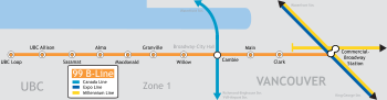
99 B-Line stops and transfer points
|}
- UBC LoopUBC LoopUBC Loop is a major public transit exchange point in the University Endowment Lands adjacent to Vancouver, British Columbia, Canada. It mostly serves students, staff and faculty members of the University of British Columbia. The loop is part of the TransLink system and currently contains two...
- The western terminus of the line serving UBC's campus centre. - UBC Allison - Formerly known as UBC Wesbrook. It is the eastern-most stop in the University Endowment LandsUniversity Endowment LandsThe University Endowment Lands is an unincorporated area that lies to the west of the city of Vancouver, British Columbia, Canada surrounding the University of British Columbia...
before entering the city of VancouverVancouverVancouver is a coastal seaport city on the mainland of British Columbia, Canada. It is the hub of Greater Vancouver, which, with over 2.3 million residents, is the third most populous metropolitan area in the country,...
. Serves the University Marketplace http://www.universitymarketplace.net/ shopping area as well as the residents around it. - Sasamat - Serves the West Point GreyWest Point GreyWest Point Grey is a neighbourhood on the western side of the city of Vancouver, British Columbia, Canada. It is bordered by 16th Avenue to the south, Alma Street to the east, English Bay to the north, and Blanca Street to the west...
neighbourhood. Is the western-most stop in Vancouver before entering the University Endowment Lands. - Alma - Connects to trolley bus routes to the Dunbar corridor. Also a short walk from Jericho Beach.
- Macdonald - Transfer point to the #22 bus, which travels into downtown Vancouver via Macdonald, Cornwall and Burrard Streets. This route is also used for those going to Vanier Park, the Vancouver MuseumVancouver MuseumThe Museum of Vancouver is a local museum located in Vanier Park, Vancouver, British Columbia. The MOV is the largest civic museum in Canada. The museum was founded in 1894 and recently went through a major re-visioning process in 2008. It shares facilities with the H. R...
, the H. R. MacMillan Space Centre and Saint Paul's Hospital. - Arbutus - This stop was added on December 14, 2009. Serves the KitsilanoKitsilanoKitsilano is an upmarket neighbourhood on the West Side of the city of Vancouver, British Columbia, Canada.Known colloquially as "Kits", this neighborhood is home to many yuppies, young families and students as well as yoga studios, organic markets, cafes and Vancouver's Greektown. The primary...
neighbourhood and provides connections to the #16 Arbutus bus. - GranvilleGranville StreetGranville Street is a major street in Vancouver, British Columbia, Canada, and part of Highway 99.-Location:Granville Street runs generally north-south through the centre of Vancouver, passing through several neighbourhoods and commercial areas, differing appreciably in their land value and the...
- Connects to the #10 bus, which runs down Granville and into downtown. Other connections are the #16 Arbutus/29th Avenue Station29th Avenue Station29th Avenue Station is located at an at-grade portion of the Expo Line, a part of Metro Vancouver's SkyTrain rapid transit system.The station is on 29th Avenue at Atlin Street, adjacent to Slocan Park, in the area of Vancouver known as "Renfrew Heights", an older, compact community...
, #17 UBC/downtown, and the N9/N10 Night Bus routes. - Willow - Serves Vancouver General HospitalVancouver General HospitalVancouver General Hospital is a medical facility located in Vancouver, British Columbia. It is the largest facility in the Vancouver Hospital and Health Sciences Centre group of medical facilities...
and the southern False CreekFalse CreekFalse Creek is a short inlet in the heart of Vancouver. It separates downtown from the rest of the city. It was named by George Henry Richards during his Hydrographic survey of 1856-63. Science World is located at its eastern end and the Burrard Street Bridge crosses its western end. False Creek is...
area. Also a transfer point to route #50 False Creek South and #17 Oak. - CambieCambie StreetCambie Street is a street in Vancouver, British Columbia, Canada. It is named for Henry John Cambie, chief surveyor of the Canadian Pacific Railway's western division ....
- Transfer point to the Canada LineCanada LineCanada Line is a rapid transit line in the Metro Vancouver region of British Columbia, Canada. Opened in August 2009, it is the third line in TransLink's SkyTrain metro network, servicing Vancouver, Richmond, and the Vancouver International Airport...
(Broadway – City Hall Station) to downtown, RichmondRichmond, British ColumbiaRichmond is a coastal city, incorporated in the Canadian province of British Columbia. Part of Metro Vancouver, its neighbouring communities are Vancouver and Burnaby to the north, New Westminster to the east, and Delta to the south, while the Strait of Georgia forms its western border...
and Vancouver International AirportVancouver International AirportVancouver International Airport is located on Sea Island in Richmond, British Columbia, Canada, about from Downtown Vancouver. In 2010 it was the second busiest airport in Canada by aircraft movements and passengers , behind Toronto Pearson International Airport, with non-stop flights daily to...
. The Canada Line also serves as a connection to bus routes to SurreySurrey, British ColumbiaSurrey is a city in the province of British Columbia, Canada. It is a member municipality of Metro Vancouver, the governing body of the Greater Vancouver Regional District...
, White RockWhite Rock, British ColumbiaWhite Rock is a city in British Columbia, Canada, that lies within the Metro Vancouver regional district. It borders Semiahmoo Bay and is surrounded on three sides by the City of Surrey, British Columbia. To the south lies the Semiahmoo First Nation, which is within the city limits of Surrey...
and DeltaDelta, British ColumbiaDelta is a district municipality in British Columbia, and forms part of Metro Vancouver. Located south of Richmond, it is bordered by the Fraser River to the north, the United States to the south and the city of Surrey to the east...
. Also serving this station is Vancouver City HallVancouver City HallVancouver City Hall is home to Vancouver City Council in Vancouver, British Columbia. Located at 453 West 12th Avenue, the building was ordered by the Vancouver Civic Building Committee, designed by architect Fred Townley and Matheson, and built by Carter, Halls, Aldinger and Company...
and the #15 bus that runs down Cambie Street to downtown. - MainMain Street (Vancouver)Main Street is a major north-south thoroughfare bisecting Vancouver, British Columbia, Canada. It runs from Waterfront Road by Burrard Inlet in the north, to Kent Avenue alongside the north arm of the Fraser River in the south.-Route:...
- Transfer point to the #3 bus that operates between Main Street, TELUS World of Science (better known as Science World) and downtown. Also a short distance from Pacific Central StationPacific Central Station (Vancouver)Pacific Central Station in Vancouver, British Columbia, Canada is a railway station that acts as the western terminus of Via Rail's cross-country The Canadian to Toronto and the northern terminus of Amtrak’s Cascades to Seattle, Portland, and Eugene, Oregon...
, which is the terminus for long-distance train routes and GreyhoundGreyhound LinesGreyhound Lines, Inc., based in Dallas, Texas, is an intercity common carrier of passengers by bus serving over 3,700 destinations in the United States, Canada and Mexico, operating under the well-known logo of a leaping greyhound. It was founded in Hibbing, Minnesota, USA, in 1914 and...
bus routes, and Chinatown. - Fraser - This stop was added on December 14, 2009 and provides connections to the #8 Fraser bus, which was also improved the same day by providing exclusive use of articulated trolleys.
- ClarkKnight StreetKnight Street is a major nouth-south roadway in Vancouver and Richmond, British Columbia, Canada. It is a four-lane freeway from Westminster Highway in Richmond to Marine Drive in Vancouver, thus serving as an alternate way to exit Vancouver southbound, rather than the Granville Street/Oak Street...
- Serves Vancouver Community CollegeVancouver Community CollegeVancouver Community College is a public post-secondary institution in Vancouver, British Columbia, Canada. Founded in 1965, it is the largest and oldest community college in British Columbia, with over 140 certificate and diploma programs...
. Also a short walk from the VCC–Clark SkyTrainSkyTrain (Vancouver)SkyTrain is a light rapid transit system in Metro Vancouver, British Columbia, Canada. SkyTrain has of track and uses fully automated trains on grade-separated tracks, running mostly on elevated guideways, which helps SkyTrain to hold consistently high on-time reliability...
station. - Commercial–Broadway StationCommercial–Broadway StationCommercial–Broadway Station is located on an elevated portion of the Expo Line and Millenium Line and an at-grade portion of the Millennium Line, a part of Metro Vancouver's SkyTrain rapid transit system...
- Eastern terminus of the 99 B-Line. Serves the Commercial–Broadway SkyTrain station. Also a transfer point to the #20 bus operating to Commercial Drive and Victoria Drive.
Beyond Commercial-Broadway Station
Prior to the opening of the SkyTrain's Millennium Line, the 99 B-Line serviced these stops in addition to the ones above.- BoundaryBoundary Road (Vancouver/Burnaby)Boundary Road is one of the most important traffic corridors in Metro Vancouver, British Columbia, Canada. It runs south from Burrard Inlet to the Fraser River separating Vancouver from Burnaby....
- Served the area at the Burnaby/Vancouver border. Was also a transfer point to the #9 bus. It was just prior to this stop that the route leaves Broadway, which turns into Lougheed Highway. Some runs of the current #99 B-Line operate to Boundary when going to and from the Burnaby bus depot. - Brentwood MallBrentwood Town CentreBrentwood Town Centre is a shopping mall in Burnaby, British Columbia. It is located in North Burnaby, at the intersection of Willingdon Avenue and the Lougheed Highway, approximately 1.5 kilometres from Vancouver city limits. It is also very close to the British Columbia Institute of Technology ...
- Served the Brentwood Town Centre shopping mall and was the first stop in Burnaby (excluding Boundary, because it straddled city limits). Brentwood still is a popular transfer point to North Burnaby bus routes to this day. Replaced by Brentwood Town Centre StationBrentwood Town Centre StationBrentwood Town Centre Station is located on an elevated portion of the Millennium Line. The station is a part of Metro Vancouver's SkyTrain rapid transit system, and is one of the busier stations on the Millennium Line.The station is located near the intersection of Lougheed Highway and Willingdon...
on the SkyTrain. - Austin - Stopped at Government during peak hours. It was one of the first stops servicing Lougheed Mall and was also close to bus connections to Simon Fraser UniversitySimon Fraser UniversitySimon Fraser University is a Canadian public research university in British Columbia with its main campus on Burnaby Mountain in Burnaby, and satellite campuses in Vancouver and Surrey. The main campus in Burnaby, located from downtown Vancouver, was established in 1965 and has more than 34,000...
. - Lougheed MallLougheed Town CentreLougheed Town Centre is a shopping mall in Burnaby, British Columbia. It is located in the northeast corner of the city, near the border with Coquitlam....
- Served the Lougheed Town Centre shopping mall and was the eastern terminus of the 99 B-Line. It is still home to many routes going to Coquitlam, Port Moody, Pitt Meadows and Maple RidgeMaple Ridge, British ColumbiaMaple Ridge is a District Municipality in British Columbia, located in the northeastern section of Metro Vancouver. Maple Ridge has a population of approximately 68,949.-History:...
. The stop was replaced by Lougheed Town Centre StationLougheed Town Centre StationLougheed Town Centre Station is a station on the Millennium Line, part of the SkyTrain rapid transit system in Metro Vancouver, British Columbia.-Location:...
on the SkyTrain.
See also
- 98 B-Line98 B-LineThe 98 B-Line was a bus rapid transit line in Metro Vancouver, British Columbia, Canada. It connected Richmond, British Columbia to Downtown Vancouver, with a connection to Vancouver International Airport. It travelled mainly along Granville Street in Vancouver and No. 3 Road in Richmond. It was...
- 97 B-Line97 B-LineThe 97 B-Line is a bus rapid transit line in Metro Vancouver, British Columbia, Canada. It connects Coquitlam Central Station on the West Coast Express system to Lougheed Town Centre Station on the SkyTrain system. It is operated by Coast Mountain Bus Company and funded by TransLink. Going west,...
- Millennium LineMillennium LineThe Millennium Line is the second rapid transit line built in the SkyTrain light metro rapid transit system in Metro Vancouver, British Columbia, Canada. The line is owned and operated by TransLink. Millennium Line uses the colour yellow on route maps, wayfinding and station signage.-History:When...
- Expo Line
- List of bus routes in Metro Vancouver