

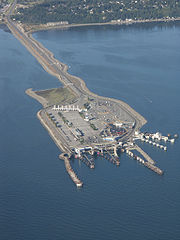
Tsawwassen Ferry Terminal
Encyclopedia
Delta, British Columbia
Delta is a district municipality in British Columbia, and forms part of Metro Vancouver. Located south of Richmond, it is bordered by the Fraser River to the north, the United States to the south and the city of Surrey to the east...
, British Columbia
British Columbia
British Columbia is the westernmost of Canada's provinces and is known for its natural beauty, as reflected in its Latin motto, Splendor sine occasu . Its name was chosen by Queen Victoria in 1858...
. It is located on a three kilometre (2 mi) man-made causeway off the mainland at Tsawwassen
Tsawwassen, British Columbia
Tsawwassen is a suburban, mostly residential community located on a peninsula in the southwestern corner of the Corporation of Delta, British Columbia, Canada. Tsawwassen provides the only road access to the community of Point Roberts, Washington via 56th Street...
and is less than 500 metres (550 yd) from the 49th parallel
49th parallel north
The 49th parallel north is a circle of latitude that is 49 degrees north of the Earth's equatorial plane. It crosses Europe, Asia, the Pacific Ocean, North America, and the Atlantic Ocean....
, Canada's border with the United States
United States
The United States of America is a federal constitutional republic comprising fifty states and a federal district...
. The terminal is part of the BC Ferry
BC Ferries
British Columbia Ferry Services Inc. or BC Ferries is a de facto Crown Corporation that provides all major passenger and vehicle ferry services for coastal and island communities in the Canadian province of British Columbia...
system, as well as part of Highway 17.
History
The search for a mainland ferry terminal in the late 1950s which would connect the Lower MainlandLower Mainland
The Lower Mainland is a name commonly applied to the region surrounding and including Vancouver, British Columbia, Canada. As of 2007, 2,524,113 people live in the region; sixteen of the province's thirty most populous municipalities are located there.While the term Lower Mainland has been...
of British Columbia with the Victoria
Victoria, British Columbia
Victoria is the capital city of British Columbia, Canada and is located on the southern tip of Vancouver Island off Canada's Pacific coast. The city has a population of about 78,000 within the metropolitan area of Greater Victoria, which has a population of 360,063, the 15th most populous Canadian...
area on Vancouver Island
Vancouver Island
Vancouver Island is a large island in British Columbia, Canada. It is one of several North American locations named after George Vancouver, the British Royal Navy officer who explored the Pacific Northwest coast of North America between 1791 and 1794...
involved an extensive scouting of locations from Steveston
Steveston, British Columbia
Steveston was originally a small town near Vancouver, British Columbia, but has since been absorbed into the city of Richmond, British Columbia....
to White Rock
White Rock, British Columbia
White Rock is a city in British Columbia, Canada, that lies within the Metro Vancouver regional district. It borders Semiahmoo Bay and is surrounded on three sides by the City of Surrey, British Columbia. To the south lies the Semiahmoo First Nation, which is within the city limits of Surrey...
. Despite criticism of rough seas and bad weather, the favoured site soon became the area offshore from the Tsawwassen First Nation Reserve
Tsawwassen First Nation
The Tsawwassen First Nation is a First Nations government whose only Indian reserve is located in the Greater Vancouver area of the Lower Mainland of British Columbia, Canada, adjacent to the South Arm of the Fraser River and the Tsawwassen Ferry Terminal and just north of the international...
.
Building of the terminal began in 1959, after provincial transportation Minister Phil Gaglardi, on divided engineering advice, selected the site. Construction of an artificial island began and the causeway was built from the island back towards the mainland. This endeavour used an estimated 2.3 million cubic metres (3.0 million cubic yards) of boulder , rock and gravel fill.
To connect Highway 99 to the new terminal, an 11 km (7 mi) long freeway was constructed from near the southern end of the Deas Tunnel
George Massey Tunnel
The George Massey Tunnel is a highway traffic tunnel in the Metro Vancouver region of southwestern British Columbia. It is located approximately 20 km south of the city centre of Vancouver, British Columbia, and approximately 30 km north of the Canada-U.S...
through the edge of Ladner
Ladner, British Columbia
Ladner was created as a fishing village on the banks of the Fraser River. It is a part of the Municipality of Delta, British Columbia, Canada, and a suburb of Vancouver....
. This became a portion of Highway 17.
The isolated causeway location of the terminal, while criticised locally in its formative years, has allowed and continues to allow terminal expansion to cope with growing vehicle traffic.
In 2003, the Tsawwassen First Nation
Tsawwassen First Nation
The Tsawwassen First Nation is a First Nations government whose only Indian reserve is located in the Greater Vancouver area of the Lower Mainland of British Columbia, Canada, adjacent to the South Arm of the Fraser River and the Tsawwassen Ferry Terminal and just north of the international...
filed legal action in B.C. Supreme Court, over the destruction of the foreshore and other concerns caused by the impact of the terminal and the nearby Roberts Bank Superport
Roberts Bank Superport
Roberts Bank Superport is a twin-terminal port facility located on the mainland coastline of the Strait of Georgia in Delta, British Columbia. Opened in 1970 with Westshore Terminals as its only tenant, Roberts Bank was expanded in 1983–84, and in June 1997 opened a second terminal, the Deltaport...
.
Concerns were also expressed in 2005 about eutrophication
Eutrophication
Eutrophication or more precisely hypertrophication, is the movement of a body of water′s trophic status in the direction of increasing plant biomass, by the addition of artificial or natural substances, such as nitrates and phosphates, through fertilizers or sewage, to an aquatic system...
, or a destructive bacterial buildup in the waters between the terminal and the Roberts Bank facility.
Ferry facilities and connections
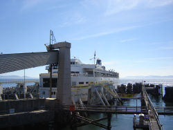
Berth (moorings)
A berth is a location in a port or harbour used specifically for mooring vessels while not at sea.-Locations in a port:Berth is the term used in ports and harbors to define a specific location where a vessel may be berthed, usually for the purposes of loading and unloading.Most berths will be...
s at the Tsawwassen Ferry Terminal. The terminal primarily serves routes travelling to the Swartz Bay Ferry Terminal
Swartz Bay Ferry Terminal
The Swartz Bay Ferry Terminal is a major transportation facility at Swartz Bay in North Saanich, British Columbia. It is located north of Victoria on Vancouver Island...
north of Victoria and the southern Gulf Islands
Gulf Islands
The Gulf Islands are the islands in the Strait of Georgia , between Vancouver Island and the mainland of British Columbia, Canada....
, although a connection from Tsawwassen to Nanaimo
Nanaimo, British Columbia
Nanaimo is a city on Vancouver Island in British Columbia, Canada. It has been dubbed the "Bathtub Racing Capital of the World" and "Harbour City". Nanaimo is also sometimes referred to as the "Hub City" because of its central location on Vancouver Island and due to the layout of the downtown...
called the "Mid-Island Express" was established in 1990, providing the shortest land connection between the border with the United States at Blaine
Blaine, Washington
Blaine is a city in Whatcom County, Washington, United States. The city's northern boundary is the Canadian border. Blaine is the shared home of the Peace Arch international monument...
and Northern Vancouver Island.
Ferries destined to, or originating from, the Gulf Islands and Swartz Bay, and landing at Tsawwassen, must travel through approximately eight kilometres of United States waters.
In the mid-1990s a major renovation and expansion of the terminal was undertaken.
The terminal is served by public transportation through Translink's 620 (Tsawwassen Ferry/Bridgeport) bus route.