

25th meridian west from Washington
Encyclopedia
Longitude
Longitude is a geographic coordinate that specifies the east-west position of a point on the Earth's surface. It is an angular measurement, usually expressed in degrees, minutes and seconds, and denoted by the Greek letter lambda ....
approximately 102.05 degrees
Degree (angle)
A degree , usually denoted by ° , is a measurement of plane angle, representing 1⁄360 of a full rotation; one degree is equivalent to π/180 radians...
west
West
West is a noun, adjective, or adverb indicating direction or geography.West is one of the four cardinal directions or compass points. It is the opposite of east and is perpendicular to north and south.By convention, the left side of a map is west....
of the Prime Meridian
Prime Meridian
The Prime Meridian is the meridian at which the longitude is defined to be 0°.The Prime Meridian and its opposite the 180th meridian , which the International Date Line generally follows, form a great circle that divides the Earth into the Eastern and Western Hemispheres.An international...
of Greenwich
Royal Observatory, Greenwich
The Royal Observatory, Greenwich , in London, England played a major role in the history of astronomy and navigation, and is best known as the location of the prime meridian...
. In the United States of America
United States
The United States of America is a federal constitutional republic comprising fifty states and a federal district...
, the meridian
Meridian (geography)
A meridian is an imaginary line on the Earth's surface from the North Pole to the South Pole that connects all locations along it with a given longitude. The position of a point along the meridian is given by its latitude. Each meridian is perpendicular to all circles of latitude...
25 degrees west of the Washington Meridian
Washington meridian
The Washington meridian was one of four prime meridians of the United States which passed through Washington, D.C.. The four which have been specified are:# through the Capitol# through the White House# through the old Naval Observatory...
defines the eastern boundary of the State of Colorado
Colorado
Colorado is a U.S. state that encompasses much of the Rocky Mountains as well as the northeastern portion of the Colorado Plateau and the western edge of the Great Plains...
, the western boundary of the State of Kansas
Kansas
Kansas is a US state located in the Midwestern United States. It is named after the Kansas River which flows through it, which in turn was named after the Kansa Native American tribe, which inhabited the area. The tribe's name is often said to mean "people of the wind" or "people of the south...
, and the western boundary of the State of Nebraska
Nebraska
Nebraska is a state on the Great Plains of the Midwestern United States. The state's capital is Lincoln and its largest city is Omaha, on the Missouri River....
south of the 41st parallel north
41st parallel north
The 41st parallel north is a circle of latitude that is 41 degrees north of the Earth's equatorial plane. It crosses Europe, the Mediterranean Sea, Asia, the Pacific Ocean, North America, and the Atlantic Ocean....
.
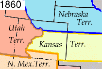
History
On January 1, 1861, the Act Admitting the State of Kansas to the UnionUnited States
The United States of America is a federal constitutional republic comprising fifty states and a federal district...
defined the western boundary of the new state as the 25th meridian of longitude west from Washington. This rendered the western portion of the Territory of Kansas unorganized. Thirty days later on February 28, 1861, the Act Organizing the Territory of Colorado defined the eastern boundary of the new territory as the 25th meridian of longitude west from Washington. The creation of the Colorado Territory
Colorado Territory
The Territory of Colorado was an organized incorporated territory of the United States that existed from February 28, 1861, until August 1, 1876, when it was admitted to the Union as the State of Colorado....
moved the western boundary of the Territory of Nebraska south of the 41st parallel north
41st parallel north
The 41st parallel north is a circle of latitude that is 41 degrees north of the Earth's equatorial plane. It crosses Europe, the Mediterranean Sea, Asia, the Pacific Ocean, North America, and the Atlantic Ocean....
east to this meridian. These boundaries on the 25th meridian of longitude west from Washington remained when Nebraska became a state on March 1, 1867, and Colorado became a state on August 1, 1876.
Longitude in the United States
LatitudeLatitude
In geography, the latitude of a location on the Earth is the angular distance of that location south or north of the Equator. The latitude is an angle, and is usually measured in degrees . The equator has a latitude of 0°, the North pole has a latitude of 90° north , and the South pole has a...
and longitude uniquely describe the location of any point on Earth. Latitude may be simply calculated from astronomical
Astronomy
Astronomy is a natural science that deals with the study of celestial objects and phenomena that originate outside the atmosphere of Earth...
or solar
Sun
The Sun is the star at the center of the Solar System. It is almost perfectly spherical and consists of hot plasma interwoven with magnetic fields...
observation, either at land or sea, interrupted only by cloudy skies. Longitude, on the other hand, requires both astronomical or solar observation and some form of time
Time
Time is a part of the measuring system used to sequence events, to compare the durations of events and the intervals between them, and to quantify rates of change such as the motions of objects....
reference to a longitude reference point. John Harrison
John Harrison
John Harrison was a self-educated English clockmaker. He invented the marine chronometer, a long-sought device in solving the problem of establishing the East-West position or longitude of a ship at sea, thus revolutionising and extending the possibility of safe long distance sea travel in the Age...
produced the first precise marine chronometer
Marine chronometer
A marine chronometer is a clock that is precise and accurate enough to be used as a portable time standard; it can therefore be used to determine longitude by means of celestial navigation...
in 1761.
The completion of the first North America
North America
North America is a continent wholly within the Northern Hemisphere and almost wholly within the Western Hemisphere. It is also considered a northern subcontinent of the Americas...
n telegraph line between Washington, D.C.
Washington, D.C.
Washington, D.C., formally the District of Columbia and commonly referred to as Washington, "the District", or simply D.C., is the capital of the United States. On July 16, 1790, the United States Congress approved the creation of a permanent national capital as permitted by the U.S. Constitution....
and Baltimore on May 24, 1844, introduced a technology that could transmit time signals at the speed of light
Speed of light
The speed of light in vacuum, usually denoted by c, is a physical constant important in many areas of physics. Its value is 299,792,458 metres per second, a figure that is exact since the length of the metre is defined from this constant and the international standard for time...
. On September 28, 1850, the United States adopted two primary meridian
Meridian (geography)
A meridian is an imaginary line on the Earth's surface from the North Pole to the South Pole that connects all locations along it with a given longitude. The position of a point along the meridian is given by its latitude. Each meridian is perpendicular to all circles of latitude...
s of longitude
Longitude
Longitude is a geographic coordinate that specifies the east-west position of a point on the Earth's surface. It is an angular measurement, usually expressed in degrees, minutes and seconds, and denoted by the Greek letter lambda ....
for officially use: the Greenwich Meridian (through the old Royal Observatory
Royal Observatory, Greenwich
The Royal Observatory, Greenwich , in London, England played a major role in the history of astronomy and navigation, and is best known as the location of the prime meridian...
at Greenwich, England) for all nautical and international use, and the Washington Meridian (through the old United States Naval Observatory
United States Naval Observatory
The United States Naval Observatory is one of the oldest scientific agencies in the United States, with a primary mission to produce Positioning, Navigation, and Timing for the U.S. Navy and the U.S. Department of Defense...
in Washington, D.C.
Washington, D.C.
Washington, D.C., formally the District of Columbia and commonly referred to as Washington, "the District", or simply D.C., is the capital of the United States. On July 16, 1790, the United States Congress approved the creation of a permanent national capital as permitted by the U.S. Constitution....
) for more accurate astronomical and domestic use. The completion of the first telegraph line across North America
North America
North America is a continent wholly within the Northern Hemisphere and almost wholly within the Western Hemisphere. It is also considered a northern subcontinent of the Americas...
, on October 24, 1861, allowed time signals from the Naval Observatory
United States Naval Observatory
The United States Naval Observatory is one of the oldest scientific agencies in the United States, with a primary mission to produce Positioning, Navigation, and Timing for the U.S. Navy and the U.S. Department of Defense...
in Washington, D.C. to be transmitted across the continent.
The United States used the Washington Meridian as the longitude reference for most states
U.S. state
A U.S. state is any one of the 50 federated states of the United States of America that share sovereignty with the federal government. Because of this shared sovereignty, an American is a citizen both of the federal entity and of his or her state of domicile. Four states use the official title of...
and territories
United States territory
United States territory is any extent of region under the jurisdiction of the federal government of the United States, including all waters including all U.S. Naval carriers. The United States has traditionally proclaimed the sovereign rights for exploring, exploiting, conserving, and managing its...
created between 1861 and 1868. The completion of the first permanent transatlantic telegraph cable
Transatlantic telegraph cable
The transatlantic telegraph cable was the first cable used for telegraph communications laid across the floor of the Atlantic Ocean. It crossed from , Foilhommerum Bay, Valentia Island, in western Ireland to Heart's Content in eastern Newfoundland. The transatlantic cable connected North America...
on July 28, 1866, allowed the United States Naval Observatory at Washington, D.C. to be synchronized
Synchronization
Synchronization is timekeeping which requires the coordination of events to operate a system in unison. The familiar conductor of an orchestra serves to keep the orchestra in time....
with the Royal Observatory at Greenwich. The need for a separate national meridian for the United States gradually faded, and in 1884, U.S. President
President of the United States
The President of the United States of America is the head of state and head of government of the United States. The president leads the executive branch of the federal government and is the commander-in-chief of the United States Armed Forces....
Chester A. Arthur
Chester A. Arthur
Chester Alan Arthur was the 21st President of the United States . Becoming President after the assassination of President James A. Garfield, Arthur struggled to overcome suspicions of his beginnings as a politician from the New York City Republican machine, succeeding at that task by embracing...
called the International Meridian Conference
International Meridian Conference
The International Meridian Conference was a conference held in October 1884 in Washington, D.C., in the United States to determine the Prime Meridian of the world. The conference was held at the request of U.S. President Chester A...
in Washington, D.C. which selected the meridian of the Royal Observatory at Greenwich as the international Prime Meridian
Prime Meridian
The Prime Meridian is the meridian at which the longitude is defined to be 0°.The Prime Meridian and its opposite the 180th meridian , which the International Date Line generally follows, form a great circle that divides the Earth into the Eastern and Western Hemispheres.An international...
. On August 12, 1912, the United States adopted the Prime Meridian of Greenwich for all uses domestic and international.