
2007 Solomon Islands earthquake
Encyclopedia
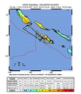
The 2007 Solomon Islands earthquake took place on 2 April 2007, near the provincial capital of Gizo
on Ghizo Island, in the Solomon Islands
. Its magnitude
was calculated by the United States Geological Survey
(USGS) as being at 8.1 on the moment magnitude scale
. The tsunami
that followed the earthquake killed 52 people.
According to the USGS, the earthquake
was recorded around 7:39:56 a.m. local time (UTC+11
). The focus was 10 km (6 mi) deep and 40 km (25 mi) South South-East of Gizo
township
on New Georgia Islands
in Western Province
. There were numerous aftershocks, the largest of which had a magnitude of 6.2.
triggered by the earthquake struck the Solomon Islands, wiping out thirteen or more villages. Thousands were left homeless, and damages are estimated in millions. The largest waves were reported on the northern tip of Simbo
Island, where maximum tsunami run-ups were 12 m, completely washing away two villages, Tapurai and Riquru, and killing 10 people. In South Choiseul, waves 10 meters high swept away villages, gardens and a hospital.
About 900 homes were destroyed.
The tsunami reached Papua New Guinea
, with a family of five reportedly missing from a remote island in Milne Bay Province
, which was in the tsunami's path.
Aid workers reported that an outbreak of diarrhea
emerged among the survivors. However, the UN reported that the outbreak and other diseases were under control as of April 12. On April 18, a measles
outbreak was reported and an immunization program was underway.
The island of Ranongga
in the New Georgia Group was lifted three meters by the earthquake, causing its beaches to shift outwards of up to 70 meters. Large coral reefs in the area are now largely above the surface and local fishermen are worried that the fishing grounds have been destroyed. However, Australian scientists said the exposure of the reefs are a normal part of island building and that careful wildlife management can preserve the reefs that remain.
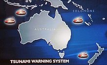
 A tsunami warning was issued for the South Pacific Ocean, and advisories issued for Japan and Hawaii. The Australian Bureau of Meteorology issued a warning for Australia's eastern coast, from Queensland's Barrier Reef to Tasmania
, and beaches along the coast were closed, while many evacuated to higher ground. However, as the epicenter was close to the Solomon Islands, the tsunami hit before the Hawaiian Pacific Tsunami Warning Center
released the warning.
High-magnitude ocean waves propagate at high speeds close to 25 meters per second, which meant that they traversed the 55-kilometer distance from the epicenter to Gavo in less than 20 minutes. Fortunately, the S-wave
s from the earthquake shook the ground and alerted the population, allowing many to flee to high ground before the wave struck.
From Honiara, one of the first warnings came from the People First Network
's Simbo email station, situated close to the epicentre. PFnet's Technical Advisor David Leeming relates that 20 minutes after the earthquake, Nickson Sioni from Simbo came on the (HF) radio and announced the arrival of a huge wave that had washed away several houses and come inland about 200m. This information was passed on by telephone to the Hawaii-based NOAA Pacific Tsunami Warning Centre who then upgraded their warning to an "expanding regional alert". This was achieved before the 35-minute arrival time of the wave for the capital Honiara, which in the event proved non-destructive.
The PFnet email station operators had been trained in disaster response by Manager Randall Biliki (late), who had previous worked as Director of the Solomon Islands National Disaster offices for nine years. All stations were equipped with UN-standard assessment forms installed on the email station laptops using Microsoft Access. Information was received from several email stations reporting on damages, needs and assessment information for several days after the tsunami, notably from badly affected Korovou in Shortland Islands.
New Zealand gave 950,000 NZD during the initial relief period, and committed 7.5 million NZD over two years to reconstruction, as of July 2007.
The United States contributed US$250,000 in aid.
Taiwan
contributed US$214,000 and shipment of 1,000 kg of rice. France has also airlifted supplies via New Caledonia
.
The United Nations
established a field hospital in Gizo, with a total of eight planned for the entire country, and also established three camps for internally displaced person
s. Australian and Canadian medical teams have also been deployed across the islands.
Papua New Guinea
, itself affected by the tsunami, has contributed US$340,000 and a light plane that can better access smaller, more remote airstrips. UNICEF issued an appeal for US$500,000 for both the Solomon Islands and Papua New Guinea.
Separately, the Red Cross
has issued an appeal for US$800,000. The remoteness of some villages meant that aid did not reach them until several days after the tsunami occurred. However, the Associated Press
reported on April 6 that Gizo's airport had reopened, easing the delivery of supplies. A Taiwanese fishing boat ran aground on coral reefs while delivering supplies, but it was successfully evacuated by a United States Navy
helicopter. The boat's crew managed to free the vessel from the rocks a few days later.
 Francis Billy Hilly, the MP for Simbo Island where 10 people died, said on April 8 that those who had previously resisted resettlement away from the island's active volcano were reconsidering their options. The national government may also relocate islanders away from low-lying areas pending a review of long-term rehabilitation and disaster preparedness plans. The Australian government announced that a network of five tsunami warning buoys will be deployed along its Pacific coast, with two buoys stationed in the Papua New Guinea/Solomon Islands area.
with, respectively, the Australia
, Woodlark, and Solomon Sea
plates. The latter three plates converge to the east-northeast or northeast against the Pacific plate with velocities of 90–105 millimetres/year. Along much of the plate boundary between the Pacific plate and the Australia/Woodlark/Solomon Sea plates, relative plate-motion is accomplished principally by subduction of the Australia/Woodlark/Solomon Sea plates beneath the Pacific plate. The April 2 earthquake's location and focal mechanism
are consistent with the earthquake having occurred as underthrusting of the Australia/Woodlark/Solomon Sea plate beneath the Pacific plate, as part of the broader northeast-directed subduction process.
The Solomon Islands arc as a whole experiences a very high level of earthquake activity, and many shocks of magnitude 7 and larger have been recorded since the early decades of the twentieth century. The April 2 earthquake, however, nucleated in a 250 kilometre-long segment of the arc that had produced no shocks of magnitude 7 or larger since the early 20th century.
Gizo
Gizo is the capital of the Western Province in the Solomon Islands. With a population of 6,154 , it is the second largest town in the country. It is situated on Ghizo Island approximately 380 kilometers west-northwest of the capital, Honiara, and is just southwest of the larger island of Kolombangara...
on Ghizo Island, in the Solomon Islands
Solomon Islands
Solomon Islands is a sovereign state in Oceania, east of Papua New Guinea, consisting of nearly one thousand islands. It covers a land mass of . The capital, Honiara, is located on the island of Guadalcanal...
. Its magnitude
Richter magnitude scale
The expression Richter magnitude scale refers to a number of ways to assign a single number to quantify the energy contained in an earthquake....
was calculated by the United States Geological Survey
United States Geological Survey
The United States Geological Survey is a scientific agency of the United States government. The scientists of the USGS study the landscape of the United States, its natural resources, and the natural hazards that threaten it. The organization has four major science disciplines, concerning biology,...
(USGS) as being at 8.1 on the moment magnitude scale
Moment magnitude scale
The moment magnitude scale is used by seismologists to measure the size of earthquakes in terms of the energy released. The magnitude is based on the seismic moment of the earthquake, which is equal to the rigidity of the Earth multiplied by the average amount of slip on the fault and the size of...
. The tsunami
Tsunami
A tsunami is a series of water waves caused by the displacement of a large volume of a body of water, typically an ocean or a large lake...
that followed the earthquake killed 52 people.
According to the USGS, the earthquake
Earthquake
An earthquake is the result of a sudden release of energy in the Earth's crust that creates seismic waves. The seismicity, seismism or seismic activity of an area refers to the frequency, type and size of earthquakes experienced over a period of time...
was recorded around 7:39:56 a.m. local time (UTC+11
UTC+11
UTC+11 is an identifier for a +11 hour time offset from UTC. This time is used in:-As standard time :*Federated States of Micronesia**Kosrae, Pohnpei and surrounding area*New Caledonia*Solomon Islands*Vanuatu*Russia...
). The focus was 10 km (6 mi) deep and 40 km (25 mi) South South-East of Gizo
Gizo
Gizo is the capital of the Western Province in the Solomon Islands. With a population of 6,154 , it is the second largest town in the country. It is situated on Ghizo Island approximately 380 kilometers west-northwest of the capital, Honiara, and is just southwest of the larger island of Kolombangara...
township
Township
The word township is used to refer to different kinds of settlements in different countries. Township is generally associated with an urban area. However there are many exceptions to this rule. In Australia, the United States, and Canada, they may be settlements too small to be considered urban...
on New Georgia Islands
New Georgia Islands
The New Georgia Islands are part of the Western Province of the Solomon Islands. They are located to the northwest of Guadalcanal. The larger islands are mountainous and covered in rain forest. The main islands are New Georgia, Vella Lavella, Kolombangara , Ghizo, Vangunu, Rendova and Tetepare...
in Western Province
Western Province (Solomon Islands)
Western Province is the largest of the provinces of the Solomon Islands. The area is renowned for its beautiful tropical islands, excellent diving and snorkelling, coral reefs and WWII wrecks, ecotourism lodges, and head-hunting shrines...
. There were numerous aftershocks, the largest of which had a magnitude of 6.2.
Effects
At least fifty-two people were reported to have been killed and sixty reported missing when a tsunamiTsunami
A tsunami is a series of water waves caused by the displacement of a large volume of a body of water, typically an ocean or a large lake...
triggered by the earthquake struck the Solomon Islands, wiping out thirteen or more villages. Thousands were left homeless, and damages are estimated in millions. The largest waves were reported on the northern tip of Simbo
Simbo
Simbo is an island in the Solomon Islands; it is located in the Western Province. It was known to early Europeans as Eddystone Island. Simbo is actually two main islands, one small island called Nusa Simbo separated by a saltwater lagoon from a larger one...
Island, where maximum tsunami run-ups were 12 m, completely washing away two villages, Tapurai and Riquru, and killing 10 people. In South Choiseul, waves 10 meters high swept away villages, gardens and a hospital.
About 900 homes were destroyed.
The tsunami reached Papua New Guinea
Papua New Guinea
Papua New Guinea , officially the Independent State of Papua New Guinea, is a country in Oceania, occupying the eastern half of the island of New Guinea and numerous offshore islands...
, with a family of five reportedly missing from a remote island in Milne Bay Province
Milne Bay Province
Milne Bay is a province of Papua New Guinea. Its capital is Alotau. The province covers 14,000 km² of land and 252,990 km² of sea, within the province there are more than 600 islands, about 160 of which are inhabited...
, which was in the tsunami's path.
Aid workers reported that an outbreak of diarrhea
Diarrhea
Diarrhea , also spelled diarrhoea, is the condition of having three or more loose or liquid bowel movements per day. It is a common cause of death in developing countries and the second most common cause of infant deaths worldwide. The loss of fluids through diarrhea can cause dehydration and...
emerged among the survivors. However, the UN reported that the outbreak and other diseases were under control as of April 12. On April 18, a measles
Measles
Measles, also known as rubeola or morbilli, is an infection of the respiratory system caused by a virus, specifically a paramyxovirus of the genus Morbillivirus. Morbilliviruses, like other paramyxoviruses, are enveloped, single-stranded, negative-sense RNA viruses...
outbreak was reported and an immunization program was underway.
The island of Ranongga
Ranongga
Ranongga is an island located in the New Georgia Islands group of Western Province, Solomon Islands.-History:Ranongga was sighted in 1787 by sailors Read and Dale....
in the New Georgia Group was lifted three meters by the earthquake, causing its beaches to shift outwards of up to 70 meters. Large coral reefs in the area are now largely above the surface and local fishermen are worried that the fishing grounds have been destroyed. However, Australian scientists said the exposure of the reefs are a normal part of island building and that careful wildlife management can preserve the reefs that remain.
Warnings
Tasmania
Tasmania is an Australian island and state. It is south of the continent, separated by Bass Strait. The state includes the island of Tasmania—the 26th largest island in the world—and the surrounding islands. The state has a population of 507,626 , of whom almost half reside in the greater Hobart...
, and beaches along the coast were closed, while many evacuated to higher ground. However, as the epicenter was close to the Solomon Islands, the tsunami hit before the Hawaiian Pacific Tsunami Warning Center
Pacific Tsunami Warning Center
The Pacific Tsunami Warning Center is one of two tsunami warning centers that are operated by NOAA in the United States. Headquartered in Ewa Beach, Hawaii, the PTWC is part of an international tsunami warning system program and serves as the operational center for TWS of the Pacific issuing...
released the warning.
High-magnitude ocean waves propagate at high speeds close to 25 meters per second, which meant that they traversed the 55-kilometer distance from the epicenter to Gavo in less than 20 minutes. Fortunately, the S-wave
S-wave
A type of seismic wave, the S-wave, secondary wave, or shear wave is one of the two main types of elastic body waves, so named because they move through the body of an object, unlike surface waves....
s from the earthquake shook the ground and alerted the population, allowing many to flee to high ground before the wave struck.
From Honiara, one of the first warnings came from the People First Network
People First Network
People First Network, also known as PFNet or Pipol Fastaem, started in Solomon Islands as part of UNDP's Solomon Islands Development Administration Planning programme and was developed by technical advisor David Leeming and others from January 2001. People First Network was initially a series of...
's Simbo email station, situated close to the epicentre. PFnet's Technical Advisor David Leeming relates that 20 minutes after the earthquake, Nickson Sioni from Simbo came on the (HF) radio and announced the arrival of a huge wave that had washed away several houses and come inland about 200m. This information was passed on by telephone to the Hawaii-based NOAA Pacific Tsunami Warning Centre who then upgraded their warning to an "expanding regional alert". This was achieved before the 35-minute arrival time of the wave for the capital Honiara, which in the event proved non-destructive.
The PFnet email station operators had been trained in disaster response by Manager Randall Biliki (late), who had previous worked as Director of the Solomon Islands National Disaster offices for nine years. All stations were equipped with UN-standard assessment forms installed on the email station laptops using Microsoft Access. Information was received from several email stations reporting on damages, needs and assessment information for several days after the tsunami, notably from badly affected Korovou in Shortland Islands.
Aid response
Australia committed to contribute an initial 3 million AUD in emergency aid, later increased to 5.7 million as of June 2007.New Zealand gave 950,000 NZD during the initial relief period, and committed 7.5 million NZD over two years to reconstruction, as of July 2007.
The United States contributed US$250,000 in aid.
Taiwan
Republic of China
The Republic of China , commonly known as Taiwan , is a unitary sovereign state located in East Asia. Originally based in mainland China, the Republic of China currently governs the island of Taiwan , which forms over 99% of its current territory, as well as Penghu, Kinmen, Matsu and other minor...
contributed US$214,000 and shipment of 1,000 kg of rice. France has also airlifted supplies via New Caledonia
New Caledonia
New Caledonia is a special collectivity of France located in the southwest Pacific Ocean, east of Australia and about from Metropolitan France. The archipelago, part of the Melanesia subregion, includes the main island of Grande Terre, the Loyalty Islands, the Belep archipelago, the Isle of...
.
The United Nations
United Nations
The United Nations is an international organization whose stated aims are facilitating cooperation in international law, international security, economic development, social progress, human rights, and achievement of world peace...
established a field hospital in Gizo, with a total of eight planned for the entire country, and also established three camps for internally displaced person
Internally displaced person
An internally displaced person is someone who is forced to flee his or her home but who remains within his or her country's borders. They are often referred to as refugees, although they do not fall within the current legal definition of a refugee. At the end of 2006 it was estimated there were...
s. Australian and Canadian medical teams have also been deployed across the islands.
Papua New Guinea
Papua New Guinea
Papua New Guinea , officially the Independent State of Papua New Guinea, is a country in Oceania, occupying the eastern half of the island of New Guinea and numerous offshore islands...
, itself affected by the tsunami, has contributed US$340,000 and a light plane that can better access smaller, more remote airstrips. UNICEF issued an appeal for US$500,000 for both the Solomon Islands and Papua New Guinea.
Separately, the Red Cross
International Red Cross and Red Crescent Movement
The International Red Cross and Red Crescent Movement is an international humanitarian movement with approximately 97 million volunteers, members and staff worldwide which was founded to protect human life and health, to ensure respect for all human beings, and to prevent and alleviate human...
has issued an appeal for US$800,000. The remoteness of some villages meant that aid did not reach them until several days after the tsunami occurred. However, the Associated Press
Associated Press
The Associated Press is an American news agency. The AP is a cooperative owned by its contributing newspapers, radio and television stations in the United States, which both contribute stories to the AP and use material written by its staff journalists...
reported on April 6 that Gizo's airport had reopened, easing the delivery of supplies. A Taiwanese fishing boat ran aground on coral reefs while delivering supplies, but it was successfully evacuated by a United States Navy
United States Navy
The United States Navy is the naval warfare service branch of the United States Armed Forces and one of the seven uniformed services of the United States. The U.S. Navy is the largest in the world; its battle fleet tonnage is greater than that of the next 13 largest navies combined. The U.S...
helicopter. The boat's crew managed to free the vessel from the rocks a few days later.
Aftermath
Tectonic summary
The earthquake occurred along the boundary of the Pacific platePacific Plate
The Pacific Plate is an oceanic tectonic plate that lies beneath the Pacific Ocean. At 103 million square kilometres, it is the largest tectonic plate....
with, respectively, the Australia
Indo-Australian Plate
The Indo-Australian Plate is a major tectonic plate that includes the continent of Australia and surrounding ocean, and extends northwest to include the Indian subcontinent and adjacent waters...
, Woodlark, and Solomon Sea
Solomon Sea
The Solomon Sea is a sea located within the Pacific Ocean. It lies between Papua New Guinea and the Solomon Islands. Many major battles were fought there during World War II.-Extent:...
plates. The latter three plates converge to the east-northeast or northeast against the Pacific plate with velocities of 90–105 millimetres/year. Along much of the plate boundary between the Pacific plate and the Australia/Woodlark/Solomon Sea plates, relative plate-motion is accomplished principally by subduction of the Australia/Woodlark/Solomon Sea plates beneath the Pacific plate. The April 2 earthquake's location and focal mechanism
Focal mechanism
The focal mechanism of an earthquake describes the inelastic deformation in the source region that generates the seismic waves. In the case of a fault-related event it refers to the orientation of the fault plane that slipped and the slip vector and is also known as a fault-plane solution...
are consistent with the earthquake having occurred as underthrusting of the Australia/Woodlark/Solomon Sea plate beneath the Pacific plate, as part of the broader northeast-directed subduction process.
The Solomon Islands arc as a whole experiences a very high level of earthquake activity, and many shocks of magnitude 7 and larger have been recorded since the early decades of the twentieth century. The April 2 earthquake, however, nucleated in a 250 kilometre-long segment of the arc that had produced no shocks of magnitude 7 or larger since the early 20th century.
External links
- Rapid Response Mission Helps Assess Earthquake Risk in South Pacific JSG Online, Dec. 7, 2007
- Stuff.co.nz:Tsunami fears after massive Solomons quake
- Associated Press: Tsunami hits Solomons
- Australian Bureau of Meteorology Tsunami Warnings summary
- NOAA - Solomon Islands - Historic Quakes
- Reuters - Solom Islands Tsunami Damage
- UNOSAT - Potential Tsunami Affected Areas
- Solomon Islands Government