

2004 and later volcanic activity of Mount St. Helens
Encyclopedia
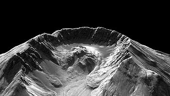
The 2004–2008 volcanic activity of Mount St. Helens has been documented as a continuous eruption with a gradual extrusion of magma
at the Mount St. Helens
volcano
in Washington, United States
. Starting in October 2004 and ceasing in January 2008, there was a gradual building of a new lava dome
. The new dome did not rise above the caldera
created by the 1980 eruption of Mount St. Helens
.
 On September 23, 2004, around 2:00 a.m. PDT, Mount St. Helens experienced an earthquake
swarm, with about 200 small (less than magnitude
1) earthquakes occurring less than one-half mile (one kilometer) below the lava dome. Activity increased, and on September 26, the U.S. Geological Survey
(USGS) and Pacific Northwest Seismograph Network
issued a "notice of volcanic unrest"
, stating that a "hazardous event" was possible, and the U.S. Forest Service
closed the mountain to all climbing. They also closed some trails in the area because of the risk of debris flow
s from the possible melting of the Crater Glacier
in the volcanic crater
.
Seismic activity continued accelerating following the USGS advisory, with earthquakes approaching magnitude 2.5 occurring at a rate of about four per minute on September 29, prompting the USGS and Pacific Northwest Seismograph Network to issue a second advisory, increasing the "alert level" to the second of three levels and warning of an increased likelihood of steam explosion
or eruption from the lava dome within the next few days. Such an event was expected to be relatively small and not pose a threat beyond the immediate area of the mountain. However, the earthquake intensities and occurrences continued to rise. In the vicinity of the volcano, earthquakes were felt as much as four in one minute. The largest earthquake recorded was a magnitude 3.3.
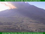
 At 12:02 p.m. PDT on October 1, 2004, the mountain threw a plume of steam and volcanic ash
about 9,700 feet (about 3 kilometers) into the air (according to pilot reports), from a vent in the then-unnamed Crater Glacier
just southwest of the lava dome. The resulting ash plume was reported to have drifted south to Vancouver, Washington
, and Wood Village, Oregon
, dusting cars with a fine layer of black, sooty ash.
 Mount St. Helens vented another burst of steam the next day at 12:14 p.m. PDT, which was stronger than the previous steam release. A low-frequency harmonic tremor
followed the steam release, which led seismologists to raise the "alert level" to the third of three levels, indicating a potential threat to life and property. Accordingly, the Johnston Ridge Observatory overlooking Mount St. Helens was evacuated; television media established their bases at Castle Lake Viewpoint about nine miles (14 km) away, while tourists moved to various locations for several miles along State Route 504.
On October 3 there was low-frequency harmonic tremor activity begin at around 3:00 a.m. PDT and lasting for up to 90 minutes, which may have indicated the movement of magma beneath the mountain. The tremors were followed by a steam release at around 10:40 a.m.
 Mount St. Helens eruptive activity continued over the following days, with steam releases occurring on October 4 at 9:47 a.m., 2:12 p.m., and at 5:40 p.m.; then again on the morning of October 5 at around 9:03 a.m., with an ash plume that dusted Randle
, Morton
, and Packwood, Washington
, towns on or near U.S. Route 12 about 30 miles (48 km) from the volcano. Between steam releases, elevated seismic activity on the mountain continued with the strongest tremors remaining near magnitude 3.0.
On October 6, the U.S. Geological Survey announced that the alert level was being lowered, saying "We no longer think that an eruption is imminent in the sense of minutes or hours."
 Magma reached the surface of the volcano around October 11, resulting in the building of a new lava dome on the existing dome's south side. Dome building continued, with the USGS reporting in early November 2004 that magma was being extruded at a rate of 7 to 10 cubic meters per second. Had magma continued to extrude at this rate uninterrupted, the crater would have been completely filled and Mount St. Helens regained its former height in about eleven years. The new dome became visible behind and to the right of the old dome, when viewed from the Johnston Ridge Observatory. The Mount St. Helens VolcanoCam located at Johnston Ridge was able to view the new dome especially at night when the glow of new magma was visible via the camera's infrared capabilities.
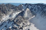 Included in the new dome was a feature dubbed the "whaleback" (named such because of its close resemblance to the back of a whale
), which was a long shaft of solidified magma being exuded by pressure of magma underneath it. This feature was very hot but fragile. The edges of it began crumbling rapidly, forming loose material around the new dome. The rate of crumbling soon matched the rate of growth, with the size of the whaleback remaining fairly constant.
, and 721 feet (220 m) below the highest point of the volcano. The whaleback feature measured approximately 1,550 feet (470 m) in length and 500 feet (150 m) in width. The diameter of the new dome was about 1,700 feet (520 m), and it contained about 50 million cubic yards (40 million cubic meters) of material. The total amount of glacier lost by this date was estimated to be 5-10%, but the flow of water from the crater was almost unchanged because the porous nature of the floor of the crater caused the water to be absorbed quickly.
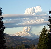 Mount St. Helens had major activity again on March 8, 2005 at about 5:30 p.m. local time, when a 36,000-foot (11 km) plume of steam and presumably ash was witnessed emerging from the volcano, accompanied by a tremor that measured about magnitude 2.5. The plume was visible from the metropolitan areas of Seattle, Washington, to Salem, Oregon
, but only lasted for about 20–30 minutes. Ash was reported falling from the sky in Yakima, Washington
, and surrounding areas. This activity was not considered a large eruption but merely a minor release of pressure consistent with the nature of dome building. Scientists believed it was triggered by a partial collapse of the lava dome. There was no increase in quake activity before the volcanic event.
 By May 5, 2005, the highest point on the new dome was 7,675 feet (2,339 m), 688 feet (210 m) below the highest point of the volcano. It contained approximately 58 million cubic yards (45 million cubic meters) of material. Growth of the new dome continued steadily, and small earthquakes continued to be observed every few minutes. The whaleback feature disintegrated steadily but continued to be extruded as solidified lava pushed upward from below.
On July 2, 2005, the tip of the whaleback feature broke off, causing a rockfall
that sent ash and dust several hundred meters into the air.
On July 21, 2006, the rim was reopened to summit hikes.
On December 19, an eruption sent a steam plume billowing over Washington.
Magma
Magma is a mixture of molten rock, volatiles and solids that is found beneath the surface of the Earth, and is expected to exist on other terrestrial planets. Besides molten rock, magma may also contain suspended crystals and dissolved gas and sometimes also gas bubbles. Magma often collects in...
at the Mount St. Helens
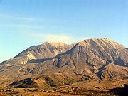
Mount St. Helens
Mount St. Helens is an active stratovolcano located in Skamania County, Washington, in the Pacific Northwest region of the United States. It is south of Seattle, Washington and northeast of Portland, Oregon. Mount St. Helens takes its English name from the British diplomat Lord St Helens, a...
volcano
Volcano
2. Bedrock3. Conduit 4. Base5. Sill6. Dike7. Layers of ash emitted by the volcano8. Flank| 9. Layers of lava emitted by the volcano10. Throat11. Parasitic cone12. Lava flow13. Vent14. Crater15...
in Washington, United States
United States
The United States of America is a federal constitutional republic comprising fifty states and a federal district...
. Starting in October 2004 and ceasing in January 2008, there was a gradual building of a new lava dome
Lava dome
|250px|thumb|right|Image of the [[rhyolitic]] lava dome of [[Chaitén Volcano]] during its 2008–2009 eruption.In volcanology, a lava dome is a roughly circular mound-shaped protrusion resulting from the slow extrusion of viscous lava from a volcano...
. The new dome did not rise above the caldera
Caldera
A caldera is a cauldron-like volcanic feature usually formed by the collapse of land following a volcanic eruption, such as the one at Yellowstone National Park in the US. They are sometimes confused with volcanic craters...
created by the 1980 eruption of Mount St. Helens
1980 eruption of Mount St. Helens
The 1980 eruption of Mount St. Helens, a stratovolcano located in Washington state, in the United States, was a major volcanic eruption. The eruption was the only significant one to occur in the contiguous 48 U.S. states since the 1915 eruption of Lassen Peak in California...
.
2004 activity
Earthquake
An earthquake is the result of a sudden release of energy in the Earth's crust that creates seismic waves. The seismicity, seismism or seismic activity of an area refers to the frequency, type and size of earthquakes experienced over a period of time...
swarm, with about 200 small (less than magnitude
Richter magnitude scale
The expression Richter magnitude scale refers to a number of ways to assign a single number to quantify the energy contained in an earthquake....
1) earthquakes occurring less than one-half mile (one kilometer) below the lava dome. Activity increased, and on September 26, the U.S. Geological Survey
United States Geological Survey
The United States Geological Survey is a scientific agency of the United States government. The scientists of the USGS study the landscape of the United States, its natural resources, and the natural hazards that threaten it. The organization has four major science disciplines, concerning biology,...
(USGS) and Pacific Northwest Seismograph Network
Pacific Northwest Seismograph Network
The Pacific Northwest Seismic Network, or PNSN collects and studies ground motions from about 400 seismometers in Oregon and Washington to monitor volcanic and tectonic activity, and gives advice and information, and works to mitigate earthquake hazard....
issued a "notice of volcanic unrest"
Volcano warning schemes
- USGS Volcano Warning Scheme for the United States :The United States Geological Survey has adopted a common system nationwide for characterizing the level of unrest and eruptive activity at volcanoes...
, stating that a "hazardous event" was possible, and the U.S. Forest Service
United States Forest Service
The United States Forest Service is an agency of the United States Department of Agriculture that administers the nation's 155 national forests and 20 national grasslands, which encompass...
closed the mountain to all climbing. They also closed some trails in the area because of the risk of debris flow
Debris flow
A debris flow is a fast moving, liquefied landslide of unconsolidated, saturated debris that looks like flowing concrete. It is differentiated from a mudflow in terms of the viscosity and textural properties of the flow. Flows can carry material ranging in size from clay to boulders, and may...
s from the possible melting of the Crater Glacier
Crater Glacier
The Crater Glacier is a geologically young glacier that is located on Mount Saint Helens, in the U.S. state of Washington. The glacier formed after the 1980 Eruption and due to its location, the body of ice grew rapidly, unknown to the public for nearly 20 years...
in the volcanic crater
Volcanic crater
A volcanic crater is a circular depression in the ground caused by volcanic activity. It is typically a basin, circular in form within which occurs a vent from which magma erupts as gases, lava, and ejecta. A crater can be of large dimensions, and sometimes of great depth...
.
Seismic activity continued accelerating following the USGS advisory, with earthquakes approaching magnitude 2.5 occurring at a rate of about four per minute on September 29, prompting the USGS and Pacific Northwest Seismograph Network to issue a second advisory, increasing the "alert level" to the second of three levels and warning of an increased likelihood of steam explosion
Phreatic eruption
A phreatic eruption, also called a phreatic explosion or ultravulcanian eruption, occurs when rising magma makes contact with ground or surface water. The extreme temperature of the magma causes near-instantaneous evaporation to steam, resulting in an explosion of steam, water, ash, rock, and...
or eruption from the lava dome within the next few days. Such an event was expected to be relatively small and not pose a threat beyond the immediate area of the mountain. However, the earthquake intensities and occurrences continued to rise. In the vicinity of the volcano, earthquakes were felt as much as four in one minute. The largest earthquake recorded was a magnitude 3.3.
Volcanic ash
Volcanic ash consists of small tephra, which are bits of pulverized rock and glass created by volcanic eruptions, less than in diameter. There are three mechanisms of volcanic ash formation: gas release under decompression causing magmatic eruptions; thermal contraction from chilling on contact...
about 9,700 feet (about 3 kilometers) into the air (according to pilot reports), from a vent in the then-unnamed Crater Glacier
Crater Glacier
The Crater Glacier is a geologically young glacier that is located on Mount Saint Helens, in the U.S. state of Washington. The glacier formed after the 1980 Eruption and due to its location, the body of ice grew rapidly, unknown to the public for nearly 20 years...
just southwest of the lava dome. The resulting ash plume was reported to have drifted south to Vancouver, Washington
Vancouver, Washington
Vancouver is a city on the north bank of the Columbia River in the U.S. state of Washington. Incorporated in 1857, it is the fourth largest city in the state with a 2010 census population of 161,791 as of April 1, 2010...
, and Wood Village, Oregon
Wood Village, Oregon
Wood Village is a city in Multnomah County, Oregon, United States. The population was 3,878 at the 2010 census. Despite the name, Wood Village is classified as a city.-Geography:...
, dusting cars with a fine layer of black, sooty ash.
Harmonic tremor
Harmonic tremor describes a long-duration release of seismic energy, with distinct spectral lines, that often precedes or accompanies a volcanic eruption...
followed the steam release, which led seismologists to raise the "alert level" to the third of three levels, indicating a potential threat to life and property. Accordingly, the Johnston Ridge Observatory overlooking Mount St. Helens was evacuated; television media established their bases at Castle Lake Viewpoint about nine miles (14 km) away, while tourists moved to various locations for several miles along State Route 504.
On October 3 there was low-frequency harmonic tremor activity begin at around 3:00 a.m. PDT and lasting for up to 90 minutes, which may have indicated the movement of magma beneath the mountain. The tremors were followed by a steam release at around 10:40 a.m.
Randle, Washington
Randle is an unincorporated community in extreme eastern Lewis County, Washington, United States. Randle is located on U.S. Route 12 and is notable as the northeastern access point to the Mount St. Helens Windy Ridge viewpoint, by way of forest service roads that cut through the Gifford Pinchot...
, Morton
Morton, Washington
Morton is a city in Lewis County, Washington, United States. The population was 1,126 at the 2010 census.-History:Morton was first settled in 1871 by James Fletcher. It was later named after Benjamin Harrison's Vice President, Levi P. Morton, in 1889. Morton was officially incorporated on January...
, and Packwood, Washington
Packwood, Washington
Packwood is an unincorporated community located in easternmost Lewis County, Washington.Packwood is located at the intersection of US Highway 12 and Gifford Pinchot National Forest Road 52 . It is located between Mount Rainier National Park to the north and Mt. St. Helens National Volcanic Monument...
, towns on or near U.S. Route 12 about 30 miles (48 km) from the volcano. Between steam releases, elevated seismic activity on the mountain continued with the strongest tremors remaining near magnitude 3.0.
On October 6, the U.S. Geological Survey announced that the alert level was being lowered, saying "We no longer think that an eruption is imminent in the sense of minutes or hours."
Whale
Whale is the common name for various marine mammals of the order Cetacea. The term whale sometimes refers to all cetaceans, but more often it excludes dolphins and porpoises, which belong to suborder Odontoceti . This suborder also includes the sperm whale, killer whale, pilot whale, and beluga...
), which was a long shaft of solidified magma being exuded by pressure of magma underneath it. This feature was very hot but fragile. The edges of it began crumbling rapidly, forming loose material around the new dome. The rate of crumbling soon matched the rate of growth, with the size of the whaleback remaining fairly constant.
2005 activity
On February 1, 2005, the new lava dome on Mount Saint Helens measured 7,642 feet (2,329 m) in elevation. This brought its elevation to 1,363 feet (415 m) above the 1980 crater floor, approximately 2,000 feet (610 m) above the surface of the Crater GlacierGlacier
A glacier is a large persistent body of ice that forms where the accumulation of snow exceeds its ablation over many years, often centuries. At least 0.1 km² in area and 50 m thick, but often much larger, a glacier slowly deforms and flows due to stresses induced by its weight...
, and 721 feet (220 m) below the highest point of the volcano. The whaleback feature measured approximately 1,550 feet (470 m) in length and 500 feet (150 m) in width. The diameter of the new dome was about 1,700 feet (520 m), and it contained about 50 million cubic yards (40 million cubic meters) of material. The total amount of glacier lost by this date was estimated to be 5-10%, but the flow of water from the crater was almost unchanged because the porous nature of the floor of the crater caused the water to be absorbed quickly.
Salem, Oregon
Salem is the capital of the U.S. state of Oregon, and the county seat of Marion County. It is located in the center of the Willamette Valley alongside the Willamette River, which runs north through the city. The river forms the boundary between Marion and Polk counties, and the city neighborhood...
, but only lasted for about 20–30 minutes. Ash was reported falling from the sky in Yakima, Washington
Yakima, Washington
Yakima is an American city southeast of Mount Rainier National Park and the county seat of Yakima County, Washington, United States, and the eighth largest city by population in the state itself. As of the 2010 census, the city had a total population of 91,196 and a metropolitan population of...
, and surrounding areas. This activity was not considered a large eruption but merely a minor release of pressure consistent with the nature of dome building. Scientists believed it was triggered by a partial collapse of the lava dome. There was no increase in quake activity before the volcanic event.
On July 2, 2005, the tip of the whaleback feature broke off, causing a rockfall
Rockfall
Rockfall or rock-fall refers to quantities of rock falling freely from a cliff face. A rockfall is a fragment of rock detached by sliding, toppling, or falling, that falls along a vertical or sub-vertical cliff, proceeds down slope by bouncing and flying along ballistic trajectories or by rolling...
that sent ash and dust several hundred meters into the air.
2006 activity
Following the collapse of the dome and whaleback, a new feature, termed the "slab", began growing. Approximately the size of a football field, the large, cooled volcanic rock was being forced upward as quickly as 6 feet (2 m) per day.On July 21, 2006, the rim was reopened to summit hikes.
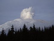
On December 19, an eruption sent a steam plume billowing over Washington.
2008 activity
On January 16, 2008, geologist John S. Pallister spotted steam seeping from the lava dome in Mount St. Helens' crater. At approximately the same time, an observatory in Vancouver, Washington recorded a magnitude 2.9 earthquake, followed by a small tremor that lasted nearly ninety minutes, and a magnitude 2.7 earthquake. But by the end of January, the lava dome growth stopped. On July 10, 2008, it was determined that the eruption that began in 2004 had ended.External links
- Mount St. Helens National Volcanic Monument website from the U.S. Forest ServiceUnited States Forest ServiceThe United States Forest Service is an agency of the United States Department of Agriculture that administers the nation's 155 national forests and 20 national grasslands, which encompass...
- Mount St. Helens National Volcanic Monument's VolcanoCam
- Mt. St. Helens webcam and current time lapse videos
- Mount St. Helens photographs and current conditions from the United States Geological SurveyUnited States Geological SurveyThe United States Geological Survey is a scientific agency of the United States government. The scientists of the USGS study the landscape of the United States, its natural resources, and the natural hazards that threaten it. The organization has four major science disciplines, concerning biology,...
website