
2000 Sri Lanka cyclone
Encyclopedia
The 2000 Sri Lanka Cyclone, (IMD designation: BOB 06 JTWC designation:04B), was the strongest tropical cyclone
to strike Sri Lanka
since 1978. The fourth tropical storm and the second severe cyclonic storm of the 2000 North Indian Ocean cyclone season
, it developed from an area of disturbed weather on December 25, 2000. It moved westward, and quickly strengthened under favorable conditions to reach top wind speeds of 75 mph (120 km/h). The cyclone hit eastern Sri Lanka
at peak strength, then weakened slightly while crossing the island before hitting and dissipating over southern India on December 28.
The storm was the first cyclone over Sri Lanka with winds of at least hurricane strength since a 110 mph (175 km/h) cyclone hit in the 1978 season, as well as the first tropical storm to hit the island since 1992. The storm was also the first December tropical cyclone of hurricane intensity in the Bay of Bengal
since 1996. It produced heavy rainfall and strong winds, damaging or destroying tens of thousands of houses and leaving up to 500,000 homeless. At least nine people died as a result of the cyclone.
developed and persisted on December 21 in the central Bay of Bengal
forming within an active near-equatorial trough
. Located within an area of weak vertical wind shear
, the system steadily organized, and after initially remaining nearly stationary it began to move slowly westward. Deep convection continued to develop, and on December 23 a mid-level circulation began to form. Later that day, the Joint Typhoon Warning Center
(JTWC) issued a Tropical Cyclone Formation Alert
. By the night of the December 23, a low-level circulation developed in the system, located to the south of the deep convection. The disturbance continued to organize, with the India Meteorological Department
(IMD) classifying it as a deep depression early on December 24. Later that day, the organization of the system degraded slightly, though it quickly reorganized. On December 25, the Joint Typhoon Warning Center initiated advisories on Tropical Cyclone 04B while it was located about 155 miles (250 km) east of Sri Lanka
. On the center's first advisory, the tropical storm was drifting west-northwest at 3 mph (5 km/h) with maximum sustained winds of 45 mph (70 km/h). Shortly thereafter, the IMD upgraded the deep depression to a cyclonic storm as a central dense overcast
developed over the center.
A subtropical ridge
to the north of the cyclone resulted in it continuing generally westward. Deep convection continued to develop over the center of circulation, and the storm steadily strengthened as outflow
improved throughout the circulation. By late on December 25, a rainband
wrapped tightly into the center, and it intensified into a severe cyclonic storm as it approached the coast of Sri Lanka. The next day the cyclone developed an eye
as it turned west-southwestward. On December 26, the cyclone made landfall
on near Trincomalee
, Sri Lanka. The JTWC assessed the cyclone as attaining peak winds of 75 mph (120 km/h). However, the IMD estimated the cyclone reached a maximum intensity of 105 mph (165 km/h), making it a very severe cyclonic storm. It weakened slightly over land and emerged into the Gulf of Mannar
early on December 27 as a tropical storm. Initially, forecasters predicted it to slowly re-intensify; instead it weakened as its convection degraded in organization and intensity. After turning west-northwestward, the storm struck southern India near Kanyakumari
on December 28 with winds of 45 mph (70 km/h), with minimal convection due to land interaction and increased wind shear
. It rapidly weakened to tropical depression status over land, and its remnants degenerated into a low pressure area after emerging into the eastern Arabian Sea
early on December 29.
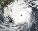
.jpg) Government officials in Sri Lanka issued a last-minute evacuation order for potentially affected areas, though few received the evacuation order. The cyclone hit the eastern and western coastlines with powerful waves, wrecking 25 fishing boats in eastern coastal towns and washing away 109 boats near Puttalam
Government officials in Sri Lanka issued a last-minute evacuation order for potentially affected areas, though few received the evacuation order. The cyclone hit the eastern and western coastlines with powerful waves, wrecking 25 fishing boats in eastern coastal towns and washing away 109 boats near Puttalam
. Eight people were left missing and feared dead. The cyclone was accompanied with a storm surge
as made landfall that flooded areas up to 330 feet (100 m) inland. While crossing the country, the cyclone dropped between 4 to 8 inches (100 to 200 mm) of precipitation, compounding the effects of severe monsoon
al flooding from the previous month. Wind gusts from the cyclone reached 110 mph (175 km/h) near where it made landfall.
The area most affected by the cyclone was in and around Trincomalee
: 57 people checked into the local hospital as a result of falling trees or debris, with one person killed due to a falling tree. An entire fishing village was completely destroyed, and heavy rainfall flooded rivers, lakes, and canals, covering roads and crops with floodwaters. The flooding destroyed about 77 square miles (200 km²) of rice fields, and an additional 19 square miles (50 km²) of other crops. Strong winds damaged or destroyed around 83,000 houses across the country, including 2,000 houses destroyed in Kinnia and 6,600 in Trincomalee. The passage of the cyclone left up to 500,000 temporarily homeless on the island, most of whom fled to churches, schools, temples, and shopping centers. The winds blew off the roofs of several police stations and military camps, and flooded several refugee camps. The winds damaged electrical systems and disrupted about 3,000 telephone systems, and many roads were left impassable. Large areas remained without power for several days. No damage reports exist for regions under control of the Liberation Tigers of Tamil Eelam
, despite the fact the storm made landfall there. Throughout the country, at least nine people died as a result of the cyclone, and over 48,000 families were affected.
Prior to the arrival of the storm in India, government officials there issued a severe storm warning for Thoothukudi District
, and also warned fishermen not to go out to sea. Thousands were evacuated to emergency shelters prior to the storm's arrival. The cyclone produced rough surf along the southern Indian coast, and heavy rainfall in and around Thoothukudi
, causing flooding in a few low-lying areas. The rainfall caused some damage to banana crops, uprooted several trees, and left some roads impassable, but was largely beneficial in alleviating drought conditions. Across southern India, the cyclone damaged 749 houses and destroyed 81 more, but no deaths were reported in the country.
 Sri Lanka governmental aid was slow at first, with the media criticizing the government for its initial response. A street protest occurred in Trincomalee
due to lack of aid. Prime Minister
Ratnasiri Wickremanayake
organized a meeting of government officials to propose an increase in relief funds. A family of five or more received $5.50 a week (2000 USD, ($ USD), 500 in 2000 LKR
) for dry rations, while the families of those who died received $183 (2000 USD, ($ USD, 2000 LKR) in compensation. The government also gave $122 (2000 USD, ($ USD, 2000 LKR) to those whose houses were damaged or destroyed, and delivered rice rations to those stranded, while state-organized radio broadcasts appealed for donations.
Within two days of the cyclone striking, the Sri Lankan Red Cross began an operation with 4,000 volunteers to help those most badly affected. The International Federation of Red Cross and Red Crescent Societies
issued a preliminary appeal for $323,000 (2000 USD, ($ USD, $ in 2000 CHF
) to assist about 10,000 people by making blankets, shelter, food, and kitchen utensils available. To kick-start the operation, the Federation released about $61,000 (2000 USD, ($ USD, $ in 2000 CHF) within a few hours of the cyclone making landfall. After about a month, the Red Cross distributed 10 roofing sheets each to 1,720 families, and also sent a set of cooking utensils, bed sheets, and sleeping mats to 3,000 families. Relief ended on November 7, 2001, roughly 40 weeks after the cyclone struck.
Tropical cyclone
A tropical cyclone is a storm system characterized by a large low-pressure center and numerous thunderstorms that produce strong winds and heavy rain. Tropical cyclones strengthen when water evaporated from the ocean is released as the saturated air rises, resulting in condensation of water vapor...
to strike Sri Lanka
Sri Lanka
Sri Lanka, officially the Democratic Socialist Republic of Sri Lanka is a country off the southern coast of the Indian subcontinent. Known until 1972 as Ceylon , Sri Lanka is an island surrounded by the Indian Ocean, the Gulf of Mannar and the Palk Strait, and lies in the vicinity of India and the...
since 1978. The fourth tropical storm and the second severe cyclonic storm of the 2000 North Indian Ocean cyclone season
2000 North Indian Ocean cyclone season
The 2000 North Indian Ocean cyclone season had no bounds, but cyclones tend to form between April and December, with peaks in May and November. These dates conventionally delimit the period of each year when most tropical cyclones form in the northern Indian Ocean.-Season summary:Six tropical...
, it developed from an area of disturbed weather on December 25, 2000. It moved westward, and quickly strengthened under favorable conditions to reach top wind speeds of 75 mph (120 km/h). The cyclone hit eastern Sri Lanka
Sri Lanka
Sri Lanka, officially the Democratic Socialist Republic of Sri Lanka is a country off the southern coast of the Indian subcontinent. Known until 1972 as Ceylon , Sri Lanka is an island surrounded by the Indian Ocean, the Gulf of Mannar and the Palk Strait, and lies in the vicinity of India and the...
at peak strength, then weakened slightly while crossing the island before hitting and dissipating over southern India on December 28.
The storm was the first cyclone over Sri Lanka with winds of at least hurricane strength since a 110 mph (175 km/h) cyclone hit in the 1978 season, as well as the first tropical storm to hit the island since 1992. The storm was also the first December tropical cyclone of hurricane intensity in the Bay of Bengal
Bay of Bengal
The Bay of Bengal , the largest bay in the world, forms the northeastern part of the Indian Ocean. It resembles a triangle in shape, and is bordered mostly by the Eastern Coast of India, southern coast of Bangladesh and Sri Lanka to the west and Burma and the Andaman and Nicobar Islands to the...
since 1996. It produced heavy rainfall and strong winds, damaging or destroying tens of thousands of houses and leaving up to 500,000 homeless. At least nine people died as a result of the cyclone.
Meteorological history
An area of atmospheric convectionAtmospheric convection
Atmospheric convection is the result of a parcel-environment instability, or temperature difference, layer in the atmosphere. Different lapse rates within dry and moist air lead to instability. Mixing of air during the day which expands the height of the planetary boundary layer leads to...
developed and persisted on December 21 in the central Bay of Bengal
Bay of Bengal
The Bay of Bengal , the largest bay in the world, forms the northeastern part of the Indian Ocean. It resembles a triangle in shape, and is bordered mostly by the Eastern Coast of India, southern coast of Bangladesh and Sri Lanka to the west and Burma and the Andaman and Nicobar Islands to the...
forming within an active near-equatorial trough
Trough (meteorology)
A trough is an elongated region of relatively low atmospheric pressure, often associated with fronts.Unlike fronts, there is not a universal symbol for a trough on a weather chart. The weather charts in some countries or regions mark troughs by a line. In the United States, a trough may be marked...
. Located within an area of weak vertical wind shear
Wind shear
Wind shear, sometimes referred to as windshear or wind gradient, is a difference in wind speed and direction over a relatively short distance in the atmosphere...
, the system steadily organized, and after initially remaining nearly stationary it began to move slowly westward. Deep convection continued to develop, and on December 23 a mid-level circulation began to form. Later that day, the Joint Typhoon Warning Center
Joint Typhoon Warning Center
The Joint Typhoon Warning Center is a joint United States Navy – United States Air Force task force located at the Naval Maritime Forecast Center in Pearl Harbor, Hawaii...
(JTWC) issued a Tropical Cyclone Formation Alert
Tropical Cyclone Formation Alert
A Tropical Cyclone Formation Alert is a bulletin released by the U.S. Navy-operated Joint Typhoon Warning Center in Honolulu, Hawaii or the Naval Maritime Forecast Center in Norfolk, Virginia, warning of the possibility of a tropical cyclone forming from a tropical disturbance that has been...
. By the night of the December 23, a low-level circulation developed in the system, located to the south of the deep convection. The disturbance continued to organize, with the India Meteorological Department
India Meteorological Department
The India Meteorological Department , also referred to as the Met Office, is an agency of the Ministry of Earth Sciences of the Government of India. It is the principal agency responsible for meteorological observations, weather forecasting and seismology...
(IMD) classifying it as a deep depression early on December 24. Later that day, the organization of the system degraded slightly, though it quickly reorganized. On December 25, the Joint Typhoon Warning Center initiated advisories on Tropical Cyclone 04B while it was located about 155 miles (250 km) east of Sri Lanka
Sri Lanka
Sri Lanka, officially the Democratic Socialist Republic of Sri Lanka is a country off the southern coast of the Indian subcontinent. Known until 1972 as Ceylon , Sri Lanka is an island surrounded by the Indian Ocean, the Gulf of Mannar and the Palk Strait, and lies in the vicinity of India and the...
. On the center's first advisory, the tropical storm was drifting west-northwest at 3 mph (5 km/h) with maximum sustained winds of 45 mph (70 km/h). Shortly thereafter, the IMD upgraded the deep depression to a cyclonic storm as a central dense overcast
Eye (cyclone)
The eye is a region of mostly calm weather found at the center of strong tropical cyclones. The eye of a storm is a roughly circular area and typically 30–65 km in diameter. It is surrounded by the eyewall, a ring of towering thunderstorms where the second most severe weather of a cyclone...
developed over the center.
A subtropical ridge
Subtropical ridge
The subtropical ridge is a significant belt of high pressure situated around the latitudes of 30°N in the Northern Hemisphere and 30°S in the Southern Hemisphere. It is characterized by mostly calm winds, which acts to reduce air quality under its axis by causing fog overnight, and haze during...
to the north of the cyclone resulted in it continuing generally westward. Deep convection continued to develop over the center of circulation, and the storm steadily strengthened as outflow
Outflow (meteorology)
Outflow, in meteorology, is air that flows outwards from a storm system. It is associated with ridging, or anticyclonic flow. In the low levels of the troposphere, outflow radiates from thunderstorms in the form of a wedge of rain-cooled air, which is visible as a thin rope-like cloud on weather...
improved throughout the circulation. By late on December 25, a rainband
Rainband
A rainband is a cloud and precipitation structure associated with an area of rainfall which is significantly elongated. Rainbands can be stratiform or convective, and are generated by differences in temperature. When noted on weather radar imagery, this precipitation elongation is referred to as...
wrapped tightly into the center, and it intensified into a severe cyclonic storm as it approached the coast of Sri Lanka. The next day the cyclone developed an eye
Eye (cyclone)
The eye is a region of mostly calm weather found at the center of strong tropical cyclones. The eye of a storm is a roughly circular area and typically 30–65 km in diameter. It is surrounded by the eyewall, a ring of towering thunderstorms where the second most severe weather of a cyclone...
as it turned west-southwestward. On December 26, the cyclone made landfall
Landfall (meteorology)
Landfall is the event of a tropical cyclone or a waterspout coming onto land after being over water. When a waterspout makes landfall it is reclassified as a tornado, which can then cause damage inland...
on near Trincomalee
Trincomalee
Trincomalee is a port city in Eastern Province, Sri Lanka and lies on the east coast of the island, about 113 miles south of Jaffna. It has a population of approximately 100,000 . The city is built on a peninsula, which divides the inner and outer harbours. Overlooking the Kottiyar Bay,...
, Sri Lanka. The JTWC assessed the cyclone as attaining peak winds of 75 mph (120 km/h). However, the IMD estimated the cyclone reached a maximum intensity of 105 mph (165 km/h), making it a very severe cyclonic storm. It weakened slightly over land and emerged into the Gulf of Mannar
Gulf of Mannar
The Gulf of Mannar is a large shallow bay forming part of the Laccadive Sea in the Indian Ocean. It lies between the southeastern tip of India and the west coast of Sri Lanka. A chain of low islands and reefs known as Adam's Bridge, also called Ramsethu, which includes Mannar Island, separates the...
early on December 27 as a tropical storm. Initially, forecasters predicted it to slowly re-intensify; instead it weakened as its convection degraded in organization and intensity. After turning west-northwestward, the storm struck southern India near Kanyakumari
Kanyakumari District
Kanyakumari District ) is a district of Tamil Nadu state, India and is the southernmost land area of mainland India.The district is the second most urbanised district in Tamilnadu, next only to Chennai and ahead of Coimbatore. It also has the highest literacy and education levels in the...
on December 28 with winds of 45 mph (70 km/h), with minimal convection due to land interaction and increased wind shear
Wind shear
Wind shear, sometimes referred to as windshear or wind gradient, is a difference in wind speed and direction over a relatively short distance in the atmosphere...
. It rapidly weakened to tropical depression status over land, and its remnants degenerated into a low pressure area after emerging into the eastern Arabian Sea
Arabian Sea
The Arabian Sea is a region of the Indian Ocean bounded on the east by India, on the north by Pakistan and Iran, on the west by the Arabian Peninsula, on the south, approximately, by a line between Cape Guardafui in northeastern Somalia and Kanyakumari in India...
early on December 29.
Impact
Puttalam
Puttalam is the capital city of the Puttalam District in North Western Province, Sri Lanka.-History:The history of this dry zone dates back to the arrival of Prince Vijaya, nearly 2500 years ago, when his vessel washed ashore. The name "Puttalam" may be a modification of the Tamil word Uppuththalam...
. Eight people were left missing and feared dead. The cyclone was accompanied with a storm surge
Storm surge
A storm surge is an offshore rise of water associated with a low pressure weather system, typically tropical cyclones and strong extratropical cyclones. Storm surges are caused primarily by high winds pushing on the ocean's surface. The wind causes the water to pile up higher than the ordinary sea...
as made landfall that flooded areas up to 330 feet (100 m) inland. While crossing the country, the cyclone dropped between 4 to 8 inches (100 to 200 mm) of precipitation, compounding the effects of severe monsoon
Monsoon
Monsoon is traditionally defined as a seasonal reversing wind accompanied by corresponding changes in precipitation, but is now used to describe seasonal changes in atmospheric circulation and precipitation associated with the asymmetric heating of land and sea...
al flooding from the previous month. Wind gusts from the cyclone reached 110 mph (175 km/h) near where it made landfall.
The area most affected by the cyclone was in and around Trincomalee
Trincomalee
Trincomalee is a port city in Eastern Province, Sri Lanka and lies on the east coast of the island, about 113 miles south of Jaffna. It has a population of approximately 100,000 . The city is built on a peninsula, which divides the inner and outer harbours. Overlooking the Kottiyar Bay,...
: 57 people checked into the local hospital as a result of falling trees or debris, with one person killed due to a falling tree. An entire fishing village was completely destroyed, and heavy rainfall flooded rivers, lakes, and canals, covering roads and crops with floodwaters. The flooding destroyed about 77 square miles (200 km²) of rice fields, and an additional 19 square miles (50 km²) of other crops. Strong winds damaged or destroyed around 83,000 houses across the country, including 2,000 houses destroyed in Kinnia and 6,600 in Trincomalee. The passage of the cyclone left up to 500,000 temporarily homeless on the island, most of whom fled to churches, schools, temples, and shopping centers. The winds blew off the roofs of several police stations and military camps, and flooded several refugee camps. The winds damaged electrical systems and disrupted about 3,000 telephone systems, and many roads were left impassable. Large areas remained without power for several days. No damage reports exist for regions under control of the Liberation Tigers of Tamil Eelam
Liberation Tigers of Tamil Eelam
The Liberation Tigers of Tamil Eelam was a separatist militant organization formerly based in northern Sri Lanka. Founded in May 1976 by Vellupillai Prabhakaran, it waged a violent secessionist and nationalist campaign to create an independent state in the north and east of Sri Lanka for Tamil...
, despite the fact the storm made landfall there. Throughout the country, at least nine people died as a result of the cyclone, and over 48,000 families were affected.
Prior to the arrival of the storm in India, government officials there issued a severe storm warning for Thoothukudi District
Thoothukudi District
Thoothukudi District, also known as Tuticorin District, is a district of Tamil Nadu state in southern India. Thoothukudi is the district headquarters. It is also known for Pearl cultivation with abundance of pearls found in the seas of Thoothukudi...
, and also warned fishermen not to go out to sea. Thousands were evacuated to emergency shelters prior to the storm's arrival. The cyclone produced rough surf along the southern Indian coast, and heavy rainfall in and around Thoothukudi
Thoothukudi
Thoothukudi , also known as Tuticorin, is a port city and a Municipal Corporation in Thoothukudi district of the Indian state of Tamil Nadu. Thoothukudi is the headquarters of Thoothukudi District....
, causing flooding in a few low-lying areas. The rainfall caused some damage to banana crops, uprooted several trees, and left some roads impassable, but was largely beneficial in alleviating drought conditions. Across southern India, the cyclone damaged 749 houses and destroyed 81 more, but no deaths were reported in the country.
Aftermath
Trincomalee
Trincomalee is a port city in Eastern Province, Sri Lanka and lies on the east coast of the island, about 113 miles south of Jaffna. It has a population of approximately 100,000 . The city is built on a peninsula, which divides the inner and outer harbours. Overlooking the Kottiyar Bay,...
due to lack of aid. Prime Minister
Prime minister
A prime minister is the most senior minister of cabinet in the executive branch of government in a parliamentary system. In many systems, the prime minister selects and may dismiss other members of the cabinet, and allocates posts to members within the government. In most systems, the prime...
Ratnasiri Wickremanayake
Ratnasiri Wickremanayake
Ratnasiri Wickremanayake MP is a Sri Lankan politician who was Prime Minister of Sri Lanka from 2000 to 2001 and again from 2005 to 2010. He is currently a National List member of the Parliament of Sri Lanka....
organized a meeting of government officials to propose an increase in relief funds. A family of five or more received $5.50 a week (2000 USD, ($ USD), 500 in 2000 LKR
Sri Lankan rupee
The rupee is the currency of Sri Lanka, divided into 100 cents. It is issued by the Central Bank of Sri Lanka and is generally written Rs. The rupee (Sinhala: රුපියල , Tamil: ரூபாய்) (sign: ₨; code: LKR) is the currency of Sri Lanka, divided into 100 cents. It is issued by the Central Bank of Sri...
) for dry rations, while the families of those who died received $183 (2000 USD, ($ USD, 2000 LKR) in compensation. The government also gave $122 (2000 USD, ($ USD, 2000 LKR) to those whose houses were damaged or destroyed, and delivered rice rations to those stranded, while state-organized radio broadcasts appealed for donations.
Within two days of the cyclone striking, the Sri Lankan Red Cross began an operation with 4,000 volunteers to help those most badly affected. The International Federation of Red Cross and Red Crescent Societies
International Federation of Red Cross and Red Crescent Societies
The International Federation of Red Cross and Red Crescent Societies is a humanitarian institution that is part of the International Red Cross and Red Crescent Movement along with the ICRC and 186 distinct National Societies...
issued a preliminary appeal for $323,000 (2000 USD, ($ USD, $ in 2000 CHF
Swiss franc
The franc is the currency and legal tender of Switzerland and Liechtenstein; it is also legal tender in the Italian exclave Campione d'Italia. Although not formally legal tender in the German exclave Büsingen , it is in wide daily use there...
) to assist about 10,000 people by making blankets, shelter, food, and kitchen utensils available. To kick-start the operation, the Federation released about $61,000 (2000 USD, ($ USD, $ in 2000 CHF) within a few hours of the cyclone making landfall. After about a month, the Red Cross distributed 10 roofing sheets each to 1,720 families, and also sent a set of cooking utensils, bed sheets, and sleeping mats to 3,000 families. Relief ended on November 7, 2001, roughly 40 weeks after the cyclone struck.