
1973 Pacific hurricane season
Encyclopedia
The 1973 Pacific hurricane season was an event in tropical cyclone
meteorology
. The most important system this year was Hurricane Ava
, which was the most intense Pacific hurricane
known at the time. Several other much weaker tropical cyclones came close to, or made landfall on, the Pacific coast of Mexico. The most serious of these was Hurricane Irah, which downed power and communication lines in parts of the Baja California Peninsula
; the other landfalling storms caused rain and some flooding. No tropical cyclone this season caused any deaths.
This season had a quick start but a slow end. Overall activity was below average, with twelve named systems in total. Of these, five were tropical storms, seven were hurricanes, of which three were major (Category 3 or higher on the Saffir-Simpson hurricane scale
). Just one storm formed in August, one of the least active Augusts ever in the east Pacific. The season officially started May 15, 1973 in the eastern Pacific, and June 1, 1973 in the central Pacific, and lasted until November 30, 1973. These dates conventionally delimit the period of each year when most tropical cyclones form in the northeastern Pacific Ocean
. All tropical cyclones this season formed in the eastern north Pacific Ocean
, often off the coast of Mexico
. As is usual in the northern hemisphere, most traveled generally westward or northwestward, and two reached as far as the waters south of the Hawaiian Islands
.
north of the equator
east of 140°W. None formed in the central north Pacific, which is the remainder of the Pacific Ocean east of the international dateline.
Of the tropical cyclones that formed this year, were twelve tropical storms and seven were hurricanes. Of those hurricanes, three of them were major hurricanes because they reached Category 3 or higher on the Saffir-Simpson Scale
. These totals are all below the long-term averages of thirteen tropical storms, nine hurricanes, and four major hurricanes. At the time, this season's total of twelve named tropical cyclones was exactly average, although at the time the climatology in this basin was weak because satellite
coverage was spotty before 1966.
This season, all advisories and tropical cyclone data were released and collected by two agencies, the Eastern Pacific Hurricane Center
in Redwood City, California
, and the Central Pacific Hurricane Center
in Honolulu, Hawaii
, both of which were coextensive with the National Weather Service
Forecast Offices in their respective cities. The EPHC covered the area between the coast of North America and 140°W, and the CPHC the remainder of the area.
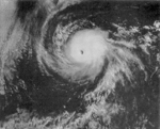
Ava's minimum central pressure was 915 millibars, and its maximum sustained wind
s reached 140 knots (274.4 km/h). This made Ava the most intense recorded east Pacific hurricane at the time. Ava reached Category 5 intensity on June 7, the earliest date in an east Pacific season that a hurricane has done so. It was also the third known Category 5 storm in the east Pacific; (behind two storms in 1959). Ava is the strongest June storm, the third most intense east Pacific hurricane, and was the only June Category 5 on record until 2010.
Ava was also flown into by hurricane hunter aircraft in what was the first penetration of a Pacific hurricane by NOAA aircraft. During these flights, radars and other devices were tested, and wind speed, pressure, and wave heights were measured. This is the reason why Hurricane Ava's pressure is measured instead of estimated. Ava was also photographed from Skylab
because it visible during one of the missions
. At that time, it was coincidentally on the surface of the Earth directly underneath the space station. All in all, these made Hurricane Ava one of the best-observed Pacific hurricane
s at the time.
spent three days organizing and finally developed into a tropical depression on June 22. The cyclone started heading northwest. After intensifying into a tropical storm, Bernice made landfall on June 23 at a location roughly 50 mi (80.5 km) southwest of Zihuatanejo
. It dissipated later that day. Bernice exposed two ships to gale
s, but otherwise neither deaths nor significant impact was reported. At its peak, Tropical Storm Bernice had winds of 70 mi/h.
. It dissipated inland the next day. No deaths or casualties were reported due to this tropical cyclone.
and was named Doreen. It steadily intensified, and became a hurricane on July 19. Doreen briefly reached Category 4 strength on July 21 with a relatively high central pressure of 972 mb. It then weakened steadily as its path carried it on a direct path to the Big Island of Hawaii. Doreen weakened to a tropical storm as it entered the Central Pacific Hurricane Center
's area of responsibility on July 25. A frontal system stuck between two high-pressure areas weakened as the two areas merged, creating a larger high pressure area that turned Doreen to the southwest on July 27. The hurricane then turned back to the northwest and strengthened back into a hurricane. It became a major hurricane again before weakening. Doreen dissipated August 3. Its remnant vortex continued westward until it dissipated under a trough near the dateline. Doreen's sudden change of track and restrengthening was unusual.
From formation to dissipation, Doreen lasted 16.25 days and traveled a distance of 4200 mi (6,759.2 km). This tied Hurricane Celeste's record for longest-lasting Pacific hurricane. Doreen was also the longest-lasting July tropical cyclone. Hurricane Fico
broke both of these records in the 1978 season
. Doreen remains the eighth-longest lasting Pacific tropical cyclone, tied with two other storms. Several ships encountered Doreen. The most serious incident involved a Greek ship called Cornelia which lost its rudder in 35 ft (10.7 m) waves, but managed to escape and continue on its way to Panama. On the afternoon of July 29, 9 ft (2.7 m) swells and 3.5 ft (1.1 m) waves were seen from Kapoho. Otherwise, no damages or deaths were blamed on this tropical cyclone.
and headed west-northwest and strengthened into a tropical storm. Emily continued moving nearly parallel to the coast before turning to the west while steadily intensifying. Emily eventually reached Category 4 intensity on July 22. Emily then weakened as it turned to the northwest. It dissipated on July 28. Emily's wind field was large enough to bring gales areas 300 mi (482.8 km) east of the hurricane from July 22 to 24. This tropical cyclone caused no deaths or damage.
. It became a tropical depression on August 30. After moving northwest for a bit, it became a tropical storm and headed almost due north towards Mexico. Heather dissipated September 1, just before making landfall. Tropical Storm Heather caused no deaths or damage to any location in the coastal area of the Gulf of Tehuantepec.
, and then dropped back down to a 1 as it recurved. It made landfall on Baja California
and entered the Gulf of California
as a tropical storm, making landfall again in northwestern Mexico approximately 30 mi (48.3 km) northwest of Los Mochis
. Irah's first landfall was the strongest of the season. The hurricane dissipated on September 27 while heading east-northeast over mainland Mexico.
Irah blew over some power
and communication lines during its passage over the southern tip of the Baja California Peninsula
. Heavy rain fell over parts of Mexico, with the highest total being 10.24 in (260.1 mm) at Sierra de la Laguna
. One person was injured and at least ten houses were destroyed in Cabo San Lucas
. No one was killed. There was some concern that the hurricane could disrupt splashdown
procedures for astronauts at the end of Skylab 3
; however, the return to Earth was not seriously affected.
. The cyclone made landfall near just southeast of Mazatlán
and dissipated September 27. Tropical Depression Jennifer caused rain over several parts of Mexico. The highest total was 7.48 in (190 mm) at Navarette/San Blas
. No one was killed and no damage was reported.
. The storm never threatened land, causing no casualties or damage.
. Storms were named Katherine and Lillian for the first time this year. No names were retired, so this list was used again in the 1977 season
. Names that weren't assigned are colored gray.
The Central Pacific used names and numbers from the Western Pacific's typhoon list. No systems formed in the area, and thus no names were required.
Tropical cyclone
A tropical cyclone is a storm system characterized by a large low-pressure center and numerous thunderstorms that produce strong winds and heavy rain. Tropical cyclones strengthen when water evaporated from the ocean is released as the saturated air rises, resulting in condensation of water vapor...
meteorology
Meteorology
Meteorology is the interdisciplinary scientific study of the atmosphere. Studies in the field stretch back millennia, though significant progress in meteorology did not occur until the 18th century. The 19th century saw breakthroughs occur after observing networks developed across several countries...
. The most important system this year was Hurricane Ava
Hurricane Ava (1973)
Hurricane Ava was one of the strongest tropical cyclones ever recorded in the northeastern Pacific Ocean. It was the first named storm of the 1973 Pacific hurricane season. Forming in early June, Hurricane Ava eventually reached Category 5 intensity on the Saffir-Simpson Hurricane Scale, the...
, which was the most intense Pacific hurricane
Pacific hurricane
A Pacific hurricane or tropical storm is a tropical cyclone that develops in the northeastern part of the Pacific Ocean. For organizational purposes, the northern Pacific Ocean is divided into three regions: the eastern, , central , and western...
known at the time. Several other much weaker tropical cyclones came close to, or made landfall on, the Pacific coast of Mexico. The most serious of these was Hurricane Irah, which downed power and communication lines in parts of the Baja California Peninsula
Baja California Peninsula
The Baja California peninsula , is a peninsula in northwestern Mexico. Its land mass separates the Pacific Ocean from the Gulf of California. The Peninsula extends from Mexicali, Baja California in the north to Cabo San Lucas, Baja California Sur in the south.The total area of the Baja California...
; the other landfalling storms caused rain and some flooding. No tropical cyclone this season caused any deaths.
This season had a quick start but a slow end. Overall activity was below average, with twelve named systems in total. Of these, five were tropical storms, seven were hurricanes, of which three were major (Category 3 or higher on the Saffir-Simpson hurricane scale
Saffir-Simpson Hurricane Scale
The Saffir–Simpson Hurricane Scale , or the Saffir–Simpson Hurricane Wind Scale , classifies hurricanes — Western Hemisphere tropical cyclones that exceed the intensities of tropical depressions and tropical storms — into five categories distinguished by the intensities of their sustained winds...
). Just one storm formed in August, one of the least active Augusts ever in the east Pacific. The season officially started May 15, 1973 in the eastern Pacific, and June 1, 1973 in the central Pacific, and lasted until November 30, 1973. These dates conventionally delimit the period of each year when most tropical cyclones form in the northeastern Pacific Ocean
Pacific Ocean
The Pacific Ocean is the largest of the Earth's oceanic divisions. It extends from the Arctic in the north to the Southern Ocean in the south, bounded by Asia and Australia in the west, and the Americas in the east.At 165.2 million square kilometres in area, this largest division of the World...
. All tropical cyclones this season formed in the eastern north Pacific Ocean
Pacific Ocean
The Pacific Ocean is the largest of the Earth's oceanic divisions. It extends from the Arctic in the north to the Southern Ocean in the south, bounded by Asia and Australia in the west, and the Americas in the east.At 165.2 million square kilometres in area, this largest division of the World...
, often off the coast of Mexico
Mexico
The United Mexican States , commonly known as Mexico , is a federal constitutional republic in North America. It is bordered on the north by the United States; on the south and west by the Pacific Ocean; on the southeast by Guatemala, Belize, and the Caribbean Sea; and on the east by the Gulf of...
. As is usual in the northern hemisphere, most traveled generally westward or northwestward, and two reached as far as the waters south of the Hawaiian Islands
Hawaiian Islands
The Hawaiian Islands are an archipelago of eight major islands, several atolls, numerous smaller islets, and undersea seamounts in the North Pacific Ocean, extending some 1,500 miles from the island of Hawaii in the south to northernmost Kure Atoll...
.
Season summary
The season began with the formation of the pre-Ava tropical depression on June 2 and ended with the dissipation of Tropical Lillian on October 9. The season lasted a total of 129 days. No named storms formed in May, three in June, four in July, one in August, three in September, one in October, and none in November. Another six tropical depressions formed during the year, but data on them is unavailable. All of these tropical cyclones formed in the eastern north Pacific tropical cyclone basin, which encompasses the Pacific OceanPacific Ocean
The Pacific Ocean is the largest of the Earth's oceanic divisions. It extends from the Arctic in the north to the Southern Ocean in the south, bounded by Asia and Australia in the west, and the Americas in the east.At 165.2 million square kilometres in area, this largest division of the World...
north of the equator
Equator
An equator is the intersection of a sphere's surface with the plane perpendicular to the sphere's axis of rotation and containing the sphere's center of mass....
east of 140°W. None formed in the central north Pacific, which is the remainder of the Pacific Ocean east of the international dateline.
Of the tropical cyclones that formed this year, were twelve tropical storms and seven were hurricanes. Of those hurricanes, three of them were major hurricanes because they reached Category 3 or higher on the Saffir-Simpson Scale
Saffir-Simpson Hurricane Scale
The Saffir–Simpson Hurricane Scale , or the Saffir–Simpson Hurricane Wind Scale , classifies hurricanes — Western Hemisphere tropical cyclones that exceed the intensities of tropical depressions and tropical storms — into five categories distinguished by the intensities of their sustained winds...
. These totals are all below the long-term averages of thirteen tropical storms, nine hurricanes, and four major hurricanes. At the time, this season's total of twelve named tropical cyclones was exactly average, although at the time the climatology in this basin was weak because satellite
Weather satellite
The weather satellite is a type of satellite that is primarily used to monitor the weather and climate of the Earth. Satellites can be either polar orbiting, seeing the same swath of the Earth every 12 hours, or geostationary, hovering over the same spot on Earth by orbiting over the equator while...
coverage was spotty before 1966.
This season, all advisories and tropical cyclone data were released and collected by two agencies, the Eastern Pacific Hurricane Center
Eastern Pacific Hurricane Center
The Eastern Pacific Hurricane Center was formerly the Regional Specialized Meteorological Center responsible for forecasting Pacific hurricanes in the eastern north Pacific east of 140°W...
in Redwood City, California
Redwood City, California
Redwood City is a California charter city located on the San Francisco Peninsula in Northern California, approximately 27 miles south of San Francisco, and 24 miles north of San Jose. Redwood City's history spans from its earliest inhabitation by the Ohlone people, to its tradition as a port for...
, and the Central Pacific Hurricane Center
Central Pacific Hurricane Center
The Central Pacific Hurricane Center of the United States National Weather Service is the official body responsible for tracking and issuing tropical cyclone warnings, watches, advisories, discussions, and statements for the Central North Pacific Basin...
in Honolulu, Hawaii
Honolulu, Hawaii
Honolulu is the capital and the most populous city of the U.S. state of Hawaii. Honolulu is the southernmost major U.S. city. Although the name "Honolulu" refers to the urban area on the southeastern shore of the island of Oahu, the city and county government are consolidated as the City and...
, both of which were coextensive with the National Weather Service
National Weather Service
The National Weather Service , once known as the Weather Bureau, is one of the six scientific agencies that make up the National Oceanic and Atmospheric Administration of the United States government...
Forecast Offices in their respective cities. The EPHC covered the area between the coast of North America and 140°W, and the CPHC the remainder of the area.
Hurricane Ava
A tropical depression formed on June 2. It steadily strengthened and headed in a generally westerly direction. It moved slowly and became Hurricane Ava on June 4. Two days later, it became a major hurricane and it sped up. On June 7, it became a Category 5 hurricane. It then started weakening and slowed down until it dissipated on June 12. No deaths or damages were attributed to Hurricane Ava.Ava's minimum central pressure was 915 millibars, and its maximum sustained wind
Maximum sustained wind
The maximum sustained winds associated with a tropical cyclone are a common indicator of the intensity of the storm. Within a mature tropical cyclone, they are found within the eyewall at a distance defined as the radius of maximum wind, or RMW. Unlike gusts, the value of these winds are...
s reached 140 knots (274.4 km/h). This made Ava the most intense recorded east Pacific hurricane at the time. Ava reached Category 5 intensity on June 7, the earliest date in an east Pacific season that a hurricane has done so. It was also the third known Category 5 storm in the east Pacific; (behind two storms in 1959). Ava is the strongest June storm, the third most intense east Pacific hurricane, and was the only June Category 5 on record until 2010.
Ava was also flown into by hurricane hunter aircraft in what was the first penetration of a Pacific hurricane by NOAA aircraft. During these flights, radars and other devices were tested, and wind speed, pressure, and wave heights were measured. This is the reason why Hurricane Ava's pressure is measured instead of estimated. Ava was also photographed from Skylab
Skylab
Skylab was a space station launched and operated by NASA, the space agency of the United States. Skylab orbited the Earth from 1973 to 1979, and included a workshop, a solar observatory, and other systems. It was launched unmanned by a modified Saturn V rocket, with a mass of...
because it visible during one of the missions
Skylab 2
-Backup crew:-Support crew:*Robert L. Crippen*Richard H. Truly*Henry W. Hartsfield, Jr*William E. Thornton-Mission parameters:*Mass: 19,979 kg*Maximum Altitude: 440 km*Distance: 18,536,730.9 km...
. At that time, it was coincidentally on the surface of the Earth directly underneath the space station. All in all, these made Hurricane Ava one of the best-observed Pacific hurricane
Pacific hurricane
A Pacific hurricane or tropical storm is a tropical cyclone that develops in the northeastern part of the Pacific Ocean. For organizational purposes, the northern Pacific Ocean is divided into three regions: the eastern, , central , and western...
s at the time.
Tropical Storm Bernice
A nearly stationary disturbance in the Intertropical Convergence ZoneIntertropical Convergence Zone
The Intertropical Convergence Zone , known by sailors as The Doldrums, is the area encircling the earth near the equator where winds originating in the northern and southern hemispheres come together....
spent three days organizing and finally developed into a tropical depression on June 22. The cyclone started heading northwest. After intensifying into a tropical storm, Bernice made landfall on June 23 at a location roughly 50 mi (80.5 km) southwest of Zihuatanejo
Zihuatanejo
Zihuatanejo or Ixtapa-Zihuatanejo, is the fourth-largest city in the Mexican state of Guerrero. Politically the city belongs to the municipality of Zihuatanejo de Azueta in the western part of Guerrero, but both are commonly referred to as Zihuatanejo...
. It dissipated later that day. Bernice exposed two ships to gale
Gale
A gale is a very strong wind. There are conflicting definitions of how strong a wind must be to be considered a gale. The U.S. government's National Weather Service defines a gale as 34–47 knots of sustained surface winds. Forecasters typically issue gale warnings when winds of this strength are...
s, but otherwise neither deaths nor significant impact was reported. At its peak, Tropical Storm Bernice had winds of 70 mi/h.
Tropical Storm Claudia
A tropical depression formed June 26 from a westward-moving area of disturbed weather. The next day, it developed gale-force winds and was named Claudia. Claudia headed northwesterly and then northwards and made landfall on June 28 approximately 30 mi (48.3 km) east of AcapulcoAcapulco
Acapulco is a city, municipality and major sea port in the state of Guerrero on the Pacific coast of Mexico, southwest from Mexico City. Acapulco is located on a deep, semi-circular bay and has been a port since the early colonial period of Mexico’s history...
. It dissipated inland the next day. No deaths or casualties were reported due to this tropical cyclone.
Hurricane Doreen
On July 18, a tropical storm formed from a disturbance in the Intertropical Convergence ZoneIntertropical Convergence Zone
The Intertropical Convergence Zone , known by sailors as The Doldrums, is the area encircling the earth near the equator where winds originating in the northern and southern hemispheres come together....
and was named Doreen. It steadily intensified, and became a hurricane on July 19. Doreen briefly reached Category 4 strength on July 21 with a relatively high central pressure of 972 mb. It then weakened steadily as its path carried it on a direct path to the Big Island of Hawaii. Doreen weakened to a tropical storm as it entered the Central Pacific Hurricane Center
Central Pacific Hurricane Center
The Central Pacific Hurricane Center of the United States National Weather Service is the official body responsible for tracking and issuing tropical cyclone warnings, watches, advisories, discussions, and statements for the Central North Pacific Basin...
's area of responsibility on July 25. A frontal system stuck between two high-pressure areas weakened as the two areas merged, creating a larger high pressure area that turned Doreen to the southwest on July 27. The hurricane then turned back to the northwest and strengthened back into a hurricane. It became a major hurricane again before weakening. Doreen dissipated August 3. Its remnant vortex continued westward until it dissipated under a trough near the dateline. Doreen's sudden change of track and restrengthening was unusual.
From formation to dissipation, Doreen lasted 16.25 days and traveled a distance of 4200 mi (6,759.2 km). This tied Hurricane Celeste's record for longest-lasting Pacific hurricane. Doreen was also the longest-lasting July tropical cyclone. Hurricane Fico
Hurricane Fico
Hurricane Fico was the longest-lived hurricane of the 1978 Pacific hurricane season and at the time was the longest-lasting Pacific hurricane on record, the record being held today by Hurricane John of 1994. The sixth tropical storm, fourth hurricane, and third major hurricane, Fico developed from...
broke both of these records in the 1978 season
1978 Pacific hurricane season
The 1978 Pacific hurricane season officially began May 15, 1978, in the eastern Pacific, June 1, 1978 in the central Pacific, and officially ended 30 November 1978. These dates conventionally delimit the period of time when tropical cyclones form in the eastern north Pacific Ocean.Activity this...
. Doreen remains the eighth-longest lasting Pacific tropical cyclone, tied with two other storms. Several ships encountered Doreen. The most serious incident involved a Greek ship called Cornelia which lost its rudder in 35 ft (10.7 m) waves, but managed to escape and continue on its way to Panama. On the afternoon of July 29, 9 ft (2.7 m) swells and 3.5 ft (1.1 m) waves were seen from Kapoho. Otherwise, no damages or deaths were blamed on this tropical cyclone.
Hurricane Emily
A depression formed July 21 from squalls in the Gulf of TehuantepecGulf of Tehuantepec
Gulf of Tehuantepec is a large body of water on the Pacific coast of the Isthmus of Tehuantepec, southeastern Mexico, at . Most of the hurricanes that form in the Eastern Pacific organize in or near this body of water...
and headed west-northwest and strengthened into a tropical storm. Emily continued moving nearly parallel to the coast before turning to the west while steadily intensifying. Emily eventually reached Category 4 intensity on July 22. Emily then weakened as it turned to the northwest. It dissipated on July 28. Emily's wind field was large enough to bring gales areas 300 mi (482.8 km) east of the hurricane from July 22 to 24. This tropical cyclone caused no deaths or damage.
Hurricane Florence
On July 25, a depression formed off the coast of Guatemala. The storm made a close approach to the Mexican coast as a depression, but did not make landfall. Just after that, it strengthened into a tropical storm. Florence headed west and then west-northwest. It became a hurricane on July 29. It began weakening thereafter. Florence dissipated on July 30. No damages or deaths were reported.Tropical Storm Glenda
A depression that had formed on July 30 from a tropical disturbance quickly strengthened into a tropical storm and was named Glenda. It took a path similar to both Florence and Emily, but further from the shore. Glenda dissipated August 5. At the time it still had winds of 40 knots (78.4 km/h), down from its peak of 60 mi/h. No deaths, damage, or other impact was reported.Tropical Storm Heather
The only storm to form in August this year formed on August 31 from an area of circulation in the ITCZ over the Gulf of TehuantepecGulf of Tehuantepec
Gulf of Tehuantepec is a large body of water on the Pacific coast of the Isthmus of Tehuantepec, southeastern Mexico, at . Most of the hurricanes that form in the Eastern Pacific organize in or near this body of water...
. It became a tropical depression on August 30. After moving northwest for a bit, it became a tropical storm and headed almost due north towards Mexico. Heather dissipated September 1, just before making landfall. Tropical Storm Heather caused no deaths or damage to any location in the coastal area of the Gulf of Tehuantepec.
Hurricane Irah
A depression formed September 22. It became a tropical storm on September 23 and a hurricane on September 24. Irah took a northwesterly path and reached Category 2 strength on the Saffir-Simpson Hurricane ScaleSaffir-Simpson Hurricane Scale
The Saffir–Simpson Hurricane Scale , or the Saffir–Simpson Hurricane Wind Scale , classifies hurricanes — Western Hemisphere tropical cyclones that exceed the intensities of tropical depressions and tropical storms — into five categories distinguished by the intensities of their sustained winds...
, and then dropped back down to a 1 as it recurved. It made landfall on Baja California
Baja California Peninsula
The Baja California peninsula , is a peninsula in northwestern Mexico. Its land mass separates the Pacific Ocean from the Gulf of California. The Peninsula extends from Mexicali, Baja California in the north to Cabo San Lucas, Baja California Sur in the south.The total area of the Baja California...
and entered the Gulf of California
Gulf of California
The Gulf of California is a body of water that separates the Baja California Peninsula from the Mexican mainland...
as a tropical storm, making landfall again in northwestern Mexico approximately 30 mi (48.3 km) northwest of Los Mochis
Los Mochis
Los Mochis is a coastal city in northern Sinaloa, Mexico. It serves as the municipal seat of the municipality of Ahome. As of the 2010 census, the population was 256,613, which was 61 percent of the municipality's population....
. Irah's first landfall was the strongest of the season. The hurricane dissipated on September 27 while heading east-northeast over mainland Mexico.
Irah blew over some power
Power Line
Power Line is an American political blog, providing news and commentary from a conservative point-of-view. It was originally written by three lawyers who attended Dartmouth College together: John H. Hinderaker, Scott W. Johnson, and Paul Mirengoff...
and communication lines during its passage over the southern tip of the Baja California Peninsula
Baja California Peninsula
The Baja California peninsula , is a peninsula in northwestern Mexico. Its land mass separates the Pacific Ocean from the Gulf of California. The Peninsula extends from Mexicali, Baja California in the north to Cabo San Lucas, Baja California Sur in the south.The total area of the Baja California...
. Heavy rain fell over parts of Mexico, with the highest total being 10.24 in (260.1 mm) at Sierra de la Laguna
Sierra de la Laguna
The Sierra de la Laguna is a mountain range on the Baja California Peninsula of Mexico. It lies at the southern end of the peninsula in the state of Baja California Sur, and is the southernmost range of the Peninsular Ranges....
. One person was injured and at least ten houses were destroyed in Cabo San Lucas
Cabo San Lucas
Cabo San Lucas , commonly called Cabo, is a city at the southern tip of the Baja California peninsula, in the municipality of Los Cabos in the Mexican state of Baja California Sur. As of the 2010 census, the population was 68,463 people...
. No one was killed. There was some concern that the hurricane could disrupt splashdown
Splashdown (spacecraft landing)
Splashdown is the method of landing a spacecraft by parachute in a body of water. It was used by American manned spacecraft prior to the Space Shuttle program. It is also possible for the Russian Soyuz spacecraft and Chinese Shenzhou spacecraft to land in water, though this is only a contingency...
procedures for astronauts at the end of Skylab 3
Skylab 3
Skylab 3 was the second manned mission to Skylab. The Skylab 3 mission started July 28, 1973, with the launch of three astronauts on the Saturn IB rocket, and lasted 59 days, 11 hours and 9 minutes...
; however, the return to Earth was not seriously affected.
Tropical Storm Jennifer
On September 23, another depression formed. It took a northeasterly path, rotating around the southern periphery of Hurricane Irah as part of a Fujiwara interaction. It strengthened into a tropical storm late on September 24. The peak windspeed of this tropical cyclone was 40 mi/h. Jennifer then weakened to a depression and turned to the north-northeast. Jennifer brushed the Islas MaríasIslas Marías
The Islas Marías are an archipelago of four islands that belong to Mexico. They are located in the Pacific Ocean, some off the coast of the state of Nayarit. They are part of the municipality of San Blas, Nayarit...
. The cyclone made landfall near just southeast of Mazatlán
Mazatlán
Mazatlán is a city in the Mexican state of Sinaloa; the surrounding municipio for which the city serves as the municipal seat is Mazatlán Municipality. It is located at on the Pacific coast, across from the southernmost tip of the Baja California peninsula.Mazatlán is a Nahuatl word meaning...
and dissipated September 27. Tropical Depression Jennifer caused rain over several parts of Mexico. The highest total was 7.48 in (190 mm) at Navarette/San Blas
San Blas, Nayarit
San Blas is both a municipality and municipal seat located on the Pacific coast of Mexico in the state of Nayarit.-City:San Blas is a port and a popular tourist destination, located about 100 miles north of Puerto Vallarta, and 40 miles west of the state capital Tepic. The town has a population of...
. No one was killed and no damage was reported.
Hurricane Katherine
Katherine became a tropical storm on September 29, just six hours after forming. It headed out to sea. On October 1, it became a hurricane. It peaked in windspeed the next day. After weakening to storm strength, it crossed 140°W and entered the central Pacific. Katherine continued its slightly south of westward track. It dropped to a depression on October 9, and dissipated shortly after that due to the influence of a cold troughTrough (meteorology)
A trough is an elongated region of relatively low atmospheric pressure, often associated with fronts.Unlike fronts, there is not a universal symbol for a trough on a weather chart. The weather charts in some countries or regions mark troughs by a line. In the United States, a trough may be marked...
. The storm never threatened land, causing no casualties or damage.
Hurricane Lillian
A depression that formed October 5 reached storm strength the same day. It generally paralleled the coast of Mexico far offshore. Lillian reached minimal hurricane strength on October 7 and peaked the next day. The hurricane began to weaken immediately thereafter and dissipated on October 9. Through its life, Lillian at first traveled generally west-northwestward, and then westward. Lillian never threatened land, causing no known impact.1973 Storm Names
These names were used for storms that formed in the eastern Pacific during this season. It is the same list used in the 1969 season1969 Pacific hurricane season
The 1969 Pacific hurricane season was an event in meteorology. It officially started on May 15, 1969 in the eastern Pacific and lasted until November 30, 1969. However, the first named storm, Ava, did not form until July 1, the latest date that the first named storm of a season formed...
. Storms were named Katherine and Lillian for the first time this year. No names were retired, so this list was used again in the 1977 season
1977 Pacific hurricane season
The 1977 Pacific hurricane season was, at the time, the least active in recorded history. Only eight tropical storms formed, and four hurricanes; they would be tied and surpassed, respectively, by the 2010 Pacific hurricane season. There were no major hurricanes; the next time this happened would...
. Names that weren't assigned are colored gray.
|
|
The Central Pacific used names and numbers from the Western Pacific's typhoon list. No systems formed in the area, and thus no names were required.
See also
- List of Pacific hurricanes
- List of Pacific hurricane seasons
- 1973 Atlantic hurricane season1973 Atlantic hurricane seasonThe 1973 Atlantic hurricane season was the first season to use the Saffir-Simpson Hurricane Scale, a scale developed in 1971 by Herbert Saffir and Robert Simpson used for rating the intensity of tropical cyclones. The season produced 24 tropical and subtropical cyclones, of which only 8 reached...
- 1973 Pacific typhoon season1973 Pacific typhoon seasonThe 1973 Pacific typhoon season has no official bounds, but most tropical cyclones tend to form in the northwestern Pacific Ocean between June and December...
- 1973 North Indian Ocean cyclone season
- Southern Hemisphere tropical cyclone seasons: 1972–73, 1973–74