
1946 Nankaido earthquake
Encyclopedia
The 1946 Nankaidō earthquake was a great earthquake
in Nankaidō
, Japan
. It occurred on December 20, 1946 at 19:19 UTC. The earthquake measured between 8.1 and 8.4 on the moment magnitude scale
, and was felt from Northern Honshū
to Kyūshū
. It occurred almost two years after the 1944 Tōnankai earthquake
, which ruptured the adjacent part of the Nankai megathrust.
, a convergent boundary
where the Philippine Sea Plate is being subducted
beneath the Eurasian Plate
. Large earthquakes have been recorded along this zone since the seventh century, with a recurrence time of 100 to 200 years.
The 1946 Nankaido earthquake was unusual in its seismological perspective, with a rupture zone estimated from long-period geodetic data that was more than twice as large as that derived from shorter period seismic data. In the center of this earthquake rupture zone, scientists used densely deployed ocean bottom seismographs to detect a subducted seamount
13 kilometres (8 mi) thick by 50 kilometres (31 mi) wide at a depth of 10 kilometres (6 mi). Scientists propose that this seamount might work as a barrier inhibiting brittle seismogenic
rupture.
Earthquake
An earthquake is the result of a sudden release of energy in the Earth's crust that creates seismic waves. The seismicity, seismism or seismic activity of an area refers to the frequency, type and size of earthquakes experienced over a period of time...
in Nankaidō
Nankaido
The , literally meaning "southern sea road," is a Japanese term denoting both an ancient division of the country and the main road running through it. The road connected provincial capitals in this region...
, Japan
Japan
Japan is an island nation in East Asia. Located in the Pacific Ocean, it lies to the east of the Sea of Japan, China, North Korea, South Korea and Russia, stretching from the Sea of Okhotsk in the north to the East China Sea and Taiwan in the south...
. It occurred on December 20, 1946 at 19:19 UTC. The earthquake measured between 8.1 and 8.4 on the moment magnitude scale
Moment magnitude scale
The moment magnitude scale is used by seismologists to measure the size of earthquakes in terms of the energy released. The magnitude is based on the seismic moment of the earthquake, which is equal to the rigidity of the Earth multiplied by the average amount of slip on the fault and the size of...
, and was felt from Northern Honshū
Honshu
is the largest island of Japan. The nation's main island, it is south of Hokkaido across the Tsugaru Strait, north of Shikoku across the Inland Sea, and northeast of Kyushu across the Kanmon Strait...
to Kyūshū
Kyushu
is the third largest island of Japan and most southwesterly of its four main islands. Its alternate ancient names include , , and . The historical regional name is referred to Kyushu and its surrounding islands....
. It occurred almost two years after the 1944 Tōnankai earthquake
1944 Tōnankai earthquake
The 1944 Tōnankai earthquake occurred at 13:35 local time on 7 December. It had an estimated magnitude of 8.1 on the moment magnitude scale and a maximum felt intensity of greater than 5 shindo . It triggered a large tsunami that caused serious damage along the coast of Wakayama Prefecture and the...
, which ruptured the adjacent part of the Nankai megathrust.
Geology
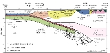
The 1946 Nankaido earthquake occurred in the Nankai TroughNankai Trough
The Nankai Trough is a submarine trough located south of Japan's island of Honshū, extending approximately 900 km offshore. In plate tectonics, the Nankai Trough marks a subduction zone that is caused by subduction of the Philippine Sea Plate beneath Japan, part of the Eurasian plate...
, a convergent boundary
Convergent boundary
In plate tectonics, a convergent boundary, also known as a destructive plate boundary , is an actively deforming region where two tectonic plates or fragments of lithosphere move toward one another and collide...
where the Philippine Sea Plate is being subducted
Subduction
In geology, subduction is the process that takes place at convergent boundaries by which one tectonic plate moves under another tectonic plate, sinking into the Earth's mantle, as the plates converge. These 3D regions of mantle downwellings are known as "Subduction Zones"...
beneath the Eurasian Plate
Eurasian Plate
The Eurasian Plate is a tectonic plate which includes most of the continent of Eurasia , with the notable exceptions of the Indian subcontinent, the Arabian subcontinent, and the area east of the Chersky Range in East Siberia...
. Large earthquakes have been recorded along this zone since the seventh century, with a recurrence time of 100 to 200 years.
The 1946 Nankaido earthquake was unusual in its seismological perspective, with a rupture zone estimated from long-period geodetic data that was more than twice as large as that derived from shorter period seismic data. In the center of this earthquake rupture zone, scientists used densely deployed ocean bottom seismographs to detect a subducted seamount
Seamount
A seamount is a mountain rising from the ocean seafloor that does not reach to the water's surface , and thus is not an island. These are typically formed from extinct volcanoes, that rise abruptly and are usually found rising from a seafloor of depth. They are defined by oceanographers as...
13 kilometres (8 mi) thick by 50 kilometres (31 mi) wide at a depth of 10 kilometres (6 mi). Scientists propose that this seamount might work as a barrier inhibiting brittle seismogenic
Seismology
Seismology is the scientific study of earthquakes and the propagation of elastic waves through the Earth or through other planet-like bodies. The field also includes studies of earthquake effects, such as tsunamis as well as diverse seismic sources such as volcanic, tectonic, oceanic,...
rupture.