

Nankaido
Encyclopedia
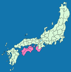
Gokishichido
was the name for ancient administrative units organized in Japan during the Asuka Period , as part of a legal and governmental system borrowed from the Chinese...
.
The Nankaidō encompassed the pre-Meiji provincial lands of Kii
Kii Province
, or , was a province of Japan in the part of Honshū that is today Wakayama Prefecture, as well as the southern part of Mie Prefecture. Kii bordered Ise, Izumi, Kawachi, Shima, and Yamato Provinces. The Kii Peninsula takes its name from this province....
and Awaji
Awaji Province
was an old province of Japan covering Awaji Island, between Honshū and Shikoku. Today it is part of Hyōgo Prefecture. It is sometimes called . Awaji is divided into three municipal sections: Awaji is the northernmost section, Sumoto is the most urban and central section, and four southern towns...
, plus the four provinces that made up the island of Shikoku
Shikoku
is the smallest and least populous of the four main islands of Japan, located south of Honshū and east of the island of Kyūshū. Its ancient names include Iyo-no-futana-shima , Iyo-shima , and Futana-shima...
: Awa
Awa Province (Tokushima)
was an old province of Japan in the area that is today a part of Tokushima Prefecture on Shikoku. Awa was bordered by Tosa, Sanuki, and Iyo Provinces. It was sometimes called .-References:...
, Sanuki
Sanuki Province
was an old province of Japan on the island of Shikoku, with the same boundaries as modern Kagawa Prefecture. It was sometimes called .It faced the Inland Sea and bordered on Awa and Iyo Provinces. Across Naruto strait it bordered Awaji Province too. Administratively it was included as a part of...
, Tosa
Tosa Province
is the name of a former province of Japan in the area that is today Kōchi Prefecture on Shikoku. Tosa was bordered by Iyo and Awa Provinces. It was sometimes called .-History:The ancient capital was near modern Nankoku...
, and Iyo
Iyo Province
was an old province of Japan in the area that is today Ehime Prefecture on Shikoku. Iyo bordered on Awa, Sanuki, and Tosa Provinces. It was sometimes called ....
.
The road extend from Nara
Nara, Nara
is the capital city of Nara Prefecture in the Kansai region of Japan. The city occupies the northern part of Nara Prefecture, directly bordering Kyoto Prefecture...
to the seacoast to the south on the Kii Peninsula
Kii Peninsula
The is the largest peninsula on the island of Honshū in Japan. The area south of the “Central Tectonic Line” is called Nankii , and includes the most poleward living coral reefs in the world due to the presence of the warm Kuroshio Current, though these are threatened by global warming and human...
of the island of Honshū
Honshu
is the largest island of Japan. The nation's main island, it is south of Hokkaido across the Tsugaru Strait, north of Shikoku across the Inland Sea, and northeast of Kyushu across the Kanmon Strait...
in Japan
Japan
Japan is an island nation in East Asia. Located in the Pacific Ocean, it lies to the east of the Sea of Japan, China, North Korea, South Korea and Russia, stretching from the Sea of Okhotsk in the north to the East China Sea and Taiwan in the south...
and crossing the sea, extended to Yura (nowadays Sumoto
Sumoto, Hyogo
is a city located on Awaji Island, Hyōgo, Japan. The city was founded on February 11, 1940.As of March 31, 2008, the city has an estimated population of 50,087 and a density of 267 persons per km²...
) and then Shikoku
Shikoku
is the smallest and least populous of the four main islands of Japan, located south of Honshū and east of the island of Kyūshū. Its ancient names include Iyo-no-futana-shima , Iyo-shima , and Futana-shima...
.
Nankaidō earthquakes
- See Historic tsunami for a full list of Nankai quakes with tsunami.
Many historic earthquakes bear the name "Nankai" or "Nankaido", as specific epicenter
Epicenter
The epicenter or epicentre is the point on the Earth's surface that is directly above the hypocenter or focus, the point where an earthquake or underground explosion originates...
s were known at the time. Often quakes take on the Japanese era name
Japanese era name
The Japanese era calendar scheme is a common calendar scheme used in Japan, which identifies a year by the combination of the and the year number within the era...
along with location such as Nankaido. These include:
- 1498 Meiō Nankaidō earthquake1498 Meiō Nankaidō earthquakeThe 1498 Meiō Nankaidō earthquake occurred off the coast of Nankai, Japan, at about 08:00 local time on 20 September, 1498. It had a magnitude estimated at 8.6 MS and triggered a large tsunami...
- 1605 Keichō Nankaidō earthquake1605 Keichō Nankaidō earthquakeThe 1605 Keichō Nankaidō earthquake occurred at about 20:00 local time on 3 February. It had an estimated magnitude of 7.9 on the surface wave magnitude scale and triggered a devastating tsunami that resulted in thousands of deaths in the Nankai and Tōkai regions of Japan. It is uncertain whether...
- 1854 Ansei-Nankai earthquake1854 Ansei-Nankai earthquakeThe 1854 Ansei-Nankai earthquake occurred at about 16:00 local time on 24 December, 1854. It had a magnitude of 8.4 and caused a damaging tsunami...
- 1944 Tōnankai earthquake1944 Tōnankai earthquakeThe 1944 Tōnankai earthquake occurred at 13:35 local time on 7 December. It had an estimated magnitude of 8.1 on the moment magnitude scale and a maximum felt intensity of greater than 5 shindo . It triggered a large tsunami that caused serious damage along the coast of Wakayama Prefecture and the...
- Nankai Earthquake1946 Nankaido earthquakeThe 1946 Nankaidō earthquake was a great earthquake in Nankaidō, Japan. It occurred on December 20, 1946 at 19:19 UTC. The earthquake measured between 8.1 and 8.4 on the moment magnitude scale, and was felt from Northern Honshū to Kyūshū...
(南海地震) measuring 8.4 hit at 4:19 [local time] there was a catastrophic earthquake on the southwest of Japan in the Nankai area. It was felt almost everywhere in the central and western parts of the country. The tsunami washed away 1451 houses, caused 1500 deaths in Japan, and was observed on tide gauges in California, Hawaii, and Peru.