
1925 Atlantic hurricane season
Encyclopedia
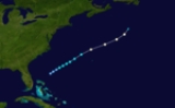
The 1925 Atlantic hurricane season was an inactive Atlantic hurricane season
during which four tropical cyclone
s, two of which were hurricanes, formed. The first storm developed on August 18, and the last dissipated on December 1. The season began at a late date, more than two months after the season began. The official start of the season is generally considered to be June 1 with the end being October 31; however, the final storm of the season formed nearly a month after the official end. Due to increased activity over the following decades, the official end of the hurricane season was shifted to November 30.
The final two storms of the season impacted several areas, with the final storm affecting areas from Cuba to Rhode Island. The third storm caused little or no damage along the Texas coastline with gale-force winds being recorded only along the coast. The last storm caused severe damage along the beaches of the Florida Peninsula
, with damages estimated in the millions along with four fatalities near Tampa. At least $600,000 was lost in damages dealt to the citrus industry and several maritime incidents resulted in over 55 fatalities.
the next day, the system was classified as a modern day tropical depression with sustained winds estimated at 30 mph (45 km/h). Roughly 18 hours later, the depression strengthened into a tropical storm, the first of the season while located to the north-northeast of the Bahamas. Gradual intensification took place throughout most of the storm's life as it traveled towards the northeast until becoming a hurricane around 0600 UTC on August 20. About 30 minutes later, a ship recorded winds of 45 mph (75 km/h) and a pressure of 993.4 mbar (hPa), the lowest pressure recorded in relation to the small storm. Shortly after, the storm reached its peak intensity with winds of 80 mph (130 km/h). Increasing in forward motion, the storm became extratropical
early on August 21 after turning towards the north.
the next day. Several hours later, a ship recorded a pressure of 1010 mbar (hPa) while located in the vicinity of the system. The storm turned towards the west-northwest later that day and forward motion began to increase.
Early on August 27, the storm weakened below tropical storm status and transitioned into an extratropical cyclone
while moving over cooler waters. The system dissipated shortly after over open waters. Although the storm remained over water for the duration of its existence, the outer reaches of the system brought rain and light winds to Georgia
, Florida
, and the Carolinas. In Jacksonville, Florida
, the storm produced 0.47 in (11.9 mm) of rain on August 25. Between August 26 and 27, Cape Hatteras
received 2.06 in (52.3 mm) of rain from the storm.
early on September 6. The system moved at a steady pace to the northwest towards the Rio Grande Valley
. Shortly after forming, the depression strengthened into a tropical storm. At this time, a ship in the vicinity of the storm recorded a pressure of 1012 mbar (hPa). By 1800 UTC
that day, the storm reached its peak intensity with winds of 50 mph (85 km/h). Around 9 pm CST (0300 UTC on September 7) that night, storm warnings were issued for areas between Brownsville
and Corpus Christi, Texas
. These warnings were later expanded to include the entire Texas coastline.
The storm made landfall in northern Mexico, just south of the Texas border, shortly after the warnings were extended. Around the time the storm made landfall, a pressure of 1002 mbar (hPa) was recorded in Brownsville, Texas. The storm dissipated later that day over southwestern Texas. No known damage was caused as a result of this storm and storm-force winds were only recorded over a small area on the Texas coastline. The storm produced minor rainfall over south Texas with Brownsville recording 0.56 in (14.2 mm) and Corpus Christi recording 0.95 in (24.1 in). Winds up to 43 mph (69 km/h) were reported in Brownsville around 1 am CST (0800 UTC) on September 7.
early on November 27, nearly a month after the official end of the hurricane season. The depression drifted towards the southeast, gradually strengthening into a tropical storm over 80°F (26.6°C) waters. Around 1300 UTC
, a ship in the vicinity of the storm recorded winds up to 40 mph (65 km/h). Once in the Gulf, forward motion picked up as it intensified to winds of 65 mph (104.6 km/h). During the night of November 30, the storm made landfall
just south of Tampa, Florida
; a pressure of 998.8 mbar (29.5 inHg) was recorded along with winds up to 52 mph (87 km/h).
Not long after making landfall, the storm weakened and transitioned into an extratropical cyclone
while over center Florida. The cyclone emerged over the eastern Atlantic Ocean several hours later and regained hurricane-force winds. By 0000 UTC, the storm reached its peak intensity as an extratropical system with winds of 90 mph (150 km/h) and a minimum pressure of 980 mbar (hPa). Around this time, the U. S. S. Patoka, which was in the vicinity of the storm, recorded a pressure of 978.5 mbar (28.9 inHg). The northeastward movement slowed shortly after crossing Florida. At around 6 p.m. EST (2300 UTC), it made landfall between Wilmington
and Cape Hatteras
with winds equivalent to a minimal hurricane. Shortly after landfall, maximum sustained winds in the storm dropped below 75 mph (120 km/h). A strong area of high pressure
located over the Canadian Maritimes caused the system to turn towards the east-southeast. On December 5, the storm weakened further to the equivalent of a tropical depression as the system began to move towards the south. The remnants of the storm continued towards the east, passing several hundred miles north of Bermuda
later that day. Several days later, the cyclone was reported near the Azores
. On December 9, it passed neat Horta where a pressure of 992.7 mbar (29.32 inHg) was recorded along with winds of 40 mph (65 km/h). After passing through the islands, it merged with another cyclone over the North Atlantic.
The storm caused significant property and crop damage along the Gulf Coast of Florida. Trees, power lines, and telegraph wires were uprooted or knocked down by high winds along the Suwannee River
. Structures which were previously considered to be safe from storms, being over 100 ft (30.4 m) inland, sustained significant damage from what was likely storm surge
. The beaches along the Atlantic coast also sustained considerable damages from the storm. Four people were killed near Tampa in two separate incidents . The first occurred when a house collapsed on three men, pinning them to the ground. The second incident occurred after a woman ran outside her home and was struck by a tree limb. In North Carolina, heavy rains and strong winds were reported along the coast. Near record high water rises were recorded around Wilmington. Cape Hatteras
was temporarily isolated from the surrounding areas as the high winds from the storm knocked down power lines throughout the area. Several buildings along the coast and numerous boats sustained considerable damage.
Throughout Florida, there were no reports of fatalities but property loses were estimated in the millions, with $1 million in Jacksonville
alone. Damages to the citrus industry were also significant, with total losses exceeding $600,000. In addition to the severe impacts on land, numerous shipping incidents resulted in several deaths. A schooner carrying seven people sunk with no survivors. A tug boat sank off the coast of Mobile, Alabama
while towing a lumber barge, the fate of the crew is unknown. A ship named the American S. S. Catopazi sank between Charleston, South Carolina
and the northern coast of Cuba
; all 30 crew members drowned. A ship carrying about 2,000 cases of liquor with a crew of six sank near Daytona Beach. The last incident, involving a yacht, occurred off the coast of Georgia. The ship sank near Savannah, Georgia
with the 12 crew members drowning. The total loss of life at sea was at least 55.
Atlantic hurricane season
The Atlantic hurricane season is the period in a year when hurricanes usually form in the Atlantic Ocean. Tropical cyclones in the North Atlantic are called hurricanes, tropical storms, or tropical depressions. In addition, there have been several storms over the years that have not been fully...
during which four tropical cyclone
Tropical cyclone
A tropical cyclone is a storm system characterized by a large low-pressure center and numerous thunderstorms that produce strong winds and heavy rain. Tropical cyclones strengthen when water evaporated from the ocean is released as the saturated air rises, resulting in condensation of water vapor...
s, two of which were hurricanes, formed. The first storm developed on August 18, and the last dissipated on December 1. The season began at a late date, more than two months after the season began. The official start of the season is generally considered to be June 1 with the end being October 31; however, the final storm of the season formed nearly a month after the official end. Due to increased activity over the following decades, the official end of the hurricane season was shifted to November 30.
The final two storms of the season impacted several areas, with the final storm affecting areas from Cuba to Rhode Island. The third storm caused little or no damage along the Texas coastline with gale-force winds being recorded only along the coast. The last storm caused severe damage along the beaches of the Florida Peninsula
Florida
Florida is a state in the southeastern United States, located on the nation's Atlantic and Gulf coasts. It is bordered to the west by the Gulf of Mexico, to the north by Alabama and Georgia and to the east by the Atlantic Ocean. With a population of 18,801,310 as measured by the 2010 census, it...
, with damages estimated in the millions along with four fatalities near Tampa. At least $600,000 was lost in damages dealt to the citrus industry and several maritime incidents resulted in over 55 fatalities.
Hurricane One
The first indications of a tropical cyclone developing were on August 17. A ship in the vicinity of the developing system reported winds of 40 mph (65 km/h) over 78°F (25.5°C) waters. Around 0000 UTCCoordinated Universal Time
Coordinated Universal Time is the primary time standard by which the world regulates clocks and time. It is one of several closely related successors to Greenwich Mean Time. Computer servers, online services and other entities that rely on having a universally accepted time use UTC for that purpose...
the next day, the system was classified as a modern day tropical depression with sustained winds estimated at 30 mph (45 km/h). Roughly 18 hours later, the depression strengthened into a tropical storm, the first of the season while located to the north-northeast of the Bahamas. Gradual intensification took place throughout most of the storm's life as it traveled towards the northeast until becoming a hurricane around 0600 UTC on August 20. About 30 minutes later, a ship recorded winds of 45 mph (75 km/h) and a pressure of 993.4 mbar (hPa), the lowest pressure recorded in relation to the small storm. Shortly after, the storm reached its peak intensity with winds of 80 mph (130 km/h). Increasing in forward motion, the storm became extratropical
Extratropical cyclone
Extratropical cyclones, sometimes called mid-latitude cyclones or wave cyclones, are a group of cyclones defined as synoptic scale low pressure weather systems that occur in the middle latitudes of the Earth having neither tropical nor polar characteristics, and are connected with fronts and...
early on August 21 after turning towards the north.
Tropical Storm Two
The second storm of the season was first identified on August 25 to the east of Florida as a tropical depression. Around this time, several ships were reporting winds up to 25 mph (35 km/h) in the vicinity of the system. Traveling towards the northeast, the storm gradually intensified, attainting tropical storm status around 0600 UTCCoordinated Universal Time
Coordinated Universal Time is the primary time standard by which the world regulates clocks and time. It is one of several closely related successors to Greenwich Mean Time. Computer servers, online services and other entities that rely on having a universally accepted time use UTC for that purpose...
the next day. Several hours later, a ship recorded a pressure of 1010 mbar (hPa) while located in the vicinity of the system. The storm turned towards the west-northwest later that day and forward motion began to increase.
Early on August 27, the storm weakened below tropical storm status and transitioned into an extratropical cyclone
Extratropical cyclone
Extratropical cyclones, sometimes called mid-latitude cyclones or wave cyclones, are a group of cyclones defined as synoptic scale low pressure weather systems that occur in the middle latitudes of the Earth having neither tropical nor polar characteristics, and are connected with fronts and...
while moving over cooler waters. The system dissipated shortly after over open waters. Although the storm remained over water for the duration of its existence, the outer reaches of the system brought rain and light winds to Georgia
Georgia (U.S. state)
Georgia is a state located in the southeastern United States. It was established in 1732, the last of the original Thirteen Colonies. The state is named after King George II of Great Britain. Georgia was the fourth state to ratify the United States Constitution, on January 2, 1788...
, Florida
Florida
Florida is a state in the southeastern United States, located on the nation's Atlantic and Gulf coasts. It is bordered to the west by the Gulf of Mexico, to the north by Alabama and Georgia and to the east by the Atlantic Ocean. With a population of 18,801,310 as measured by the 2010 census, it...
, and the Carolinas. In Jacksonville, Florida
Jacksonville, Florida
Jacksonville is the largest city in the U.S. state of Florida in terms of both population and land area, and the largest city by area in the contiguous United States. It is the county seat of Duval County, with which the city government consolidated in 1968...
, the storm produced 0.47 in (11.9 mm) of rain on August 25. Between August 26 and 27, Cape Hatteras
Cape Hatteras
Cape Hatteras is a cape on the coast of North Carolina. It is the point that protrudes the farthest to the southeast along the northeast-to-southwest line of the Atlantic coast of North America...
received 2.06 in (52.3 mm) of rain from the storm.
Tropical Storm Three
The third storm of the season was first identified as tropical depression off the northwestern coast of the Yucatan PeninsulaYucatán Peninsula
The Yucatán Peninsula, in southeastern Mexico, separates the Caribbean Sea from the Gulf of Mexico, with the northern coastline on the Yucatán Channel...
early on September 6. The system moved at a steady pace to the northwest towards the Rio Grande Valley
Rio Grande Valley
The Rio Grande Valley or the Lower Rio Grande Valley, informally called The Valley, is an area located in the southernmost tip of South Texas...
. Shortly after forming, the depression strengthened into a tropical storm. At this time, a ship in the vicinity of the storm recorded a pressure of 1012 mbar (hPa). By 1800 UTC
Coordinated Universal Time
Coordinated Universal Time is the primary time standard by which the world regulates clocks and time. It is one of several closely related successors to Greenwich Mean Time. Computer servers, online services and other entities that rely on having a universally accepted time use UTC for that purpose...
that day, the storm reached its peak intensity with winds of 50 mph (85 km/h). Around 9 pm CST (0300 UTC on September 7) that night, storm warnings were issued for areas between Brownsville
Brownsville, Texas
Brownsville is a city in the southernmost tip of the state of Texas, in the United States. It is located on the northern bank of the Rio Grande, directly north and across the border from Matamoros, Tamaulipas, Mexico. Brownsville is the 16th largest city in the state of Texas with a population of...
and Corpus Christi, Texas
Corpus Christi, Texas
Corpus Christi is a coastal city in the South Texas region of the U.S. state of Texas. The county seat of Nueces County, it also extends into Aransas, Kleberg, and San Patricio counties. The MSA population in 2008 was 416,376. The population was 305,215 at the 2010 census making it the...
. These warnings were later expanded to include the entire Texas coastline.
The storm made landfall in northern Mexico, just south of the Texas border, shortly after the warnings were extended. Around the time the storm made landfall, a pressure of 1002 mbar (hPa) was recorded in Brownsville, Texas. The storm dissipated later that day over southwestern Texas. No known damage was caused as a result of this storm and storm-force winds were only recorded over a small area on the Texas coastline. The storm produced minor rainfall over south Texas with Brownsville recording 0.56 in (14.2 mm) and Corpus Christi recording 0.95 in (24.1 in). Winds up to 43 mph (69 km/h) were reported in Brownsville around 1 am CST (0800 UTC) on September 7.
Tropical Storm Four
The final storm of the season formed as tropical depression to the southeast of the Yucatan PeninsulaYucatán Peninsula
The Yucatán Peninsula, in southeastern Mexico, separates the Caribbean Sea from the Gulf of Mexico, with the northern coastline on the Yucatán Channel...
early on November 27, nearly a month after the official end of the hurricane season. The depression drifted towards the southeast, gradually strengthening into a tropical storm over 80°F (26.6°C) waters. Around 1300 UTC
Coordinated Universal Time
Coordinated Universal Time is the primary time standard by which the world regulates clocks and time. It is one of several closely related successors to Greenwich Mean Time. Computer servers, online services and other entities that rely on having a universally accepted time use UTC for that purpose...
, a ship in the vicinity of the storm recorded winds up to 40 mph (65 km/h). Once in the Gulf, forward motion picked up as it intensified to winds of 65 mph (104.6 km/h). During the night of November 30, the storm made landfall
Landfall (meteorology)
Landfall is the event of a tropical cyclone or a waterspout coming onto land after being over water. When a waterspout makes landfall it is reclassified as a tornado, which can then cause damage inland...
just south of Tampa, Florida
Tampa, Florida
Tampa is a city in the U.S. state of Florida. It serves as the county seat for Hillsborough County. Tampa is located on the west coast of Florida. The population of Tampa in 2010 was 335,709....
; a pressure of 998.8 mbar (29.5 inHg) was recorded along with winds up to 52 mph (87 km/h).
Not long after making landfall, the storm weakened and transitioned into an extratropical cyclone
Extratropical cyclone
Extratropical cyclones, sometimes called mid-latitude cyclones or wave cyclones, are a group of cyclones defined as synoptic scale low pressure weather systems that occur in the middle latitudes of the Earth having neither tropical nor polar characteristics, and are connected with fronts and...
while over center Florida. The cyclone emerged over the eastern Atlantic Ocean several hours later and regained hurricane-force winds. By 0000 UTC, the storm reached its peak intensity as an extratropical system with winds of 90 mph (150 km/h) and a minimum pressure of 980 mbar (hPa). Around this time, the U. S. S. Patoka, which was in the vicinity of the storm, recorded a pressure of 978.5 mbar (28.9 inHg). The northeastward movement slowed shortly after crossing Florida. At around 6 p.m. EST (2300 UTC), it made landfall between Wilmington
Wilmington, North Carolina
Wilmington is a port city in and is the county seat of New Hanover County, North Carolina, United States. The population is 106,476 according to the 2010 Census, making it the eighth most populous city in the state of North Carolina...
and Cape Hatteras
Cape Hatteras
Cape Hatteras is a cape on the coast of North Carolina. It is the point that protrudes the farthest to the southeast along the northeast-to-southwest line of the Atlantic coast of North America...
with winds equivalent to a minimal hurricane. Shortly after landfall, maximum sustained winds in the storm dropped below 75 mph (120 km/h). A strong area of high pressure
High pressure area
A high-pressure area is a region where the atmospheric pressure at the surface of the planet is greater than its surrounding environment. Winds within high-pressure areas flow outward due to the higher density air near their center and friction with land...
located over the Canadian Maritimes caused the system to turn towards the east-southeast. On December 5, the storm weakened further to the equivalent of a tropical depression as the system began to move towards the south. The remnants of the storm continued towards the east, passing several hundred miles north of Bermuda
Bermuda
Bermuda is a British overseas territory in the North Atlantic Ocean. Located off the east coast of the United States, its nearest landmass is Cape Hatteras, North Carolina, about to the west-northwest. It is about south of Halifax, Nova Scotia, Canada, and northeast of Miami, Florida...
later that day. Several days later, the cyclone was reported near the Azores
Azores
The Archipelago of the Azores is composed of nine volcanic islands situated in the middle of the North Atlantic Ocean, and is located about west from Lisbon and about east from the east coast of North America. The islands, and their economic exclusion zone, form the Autonomous Region of the...
. On December 9, it passed neat Horta where a pressure of 992.7 mbar (29.32 inHg) was recorded along with winds of 40 mph (65 km/h). After passing through the islands, it merged with another cyclone over the North Atlantic.
The storm caused significant property and crop damage along the Gulf Coast of Florida. Trees, power lines, and telegraph wires were uprooted or knocked down by high winds along the Suwannee River
Suwannee River
The Suwannee River is a major river of southern Georgia and northern Florida in the United States. It is a wild blackwater river, about long. The Suwannee River is the site of the prehistoric Suwannee Straits which separated peninsular Florida from the panhandle.-Geography:The river rises in the...
. Structures which were previously considered to be safe from storms, being over 100 ft (30.4 m) inland, sustained significant damage from what was likely storm surge
Storm surge
A storm surge is an offshore rise of water associated with a low pressure weather system, typically tropical cyclones and strong extratropical cyclones. Storm surges are caused primarily by high winds pushing on the ocean's surface. The wind causes the water to pile up higher than the ordinary sea...
. The beaches along the Atlantic coast also sustained considerable damages from the storm. Four people were killed near Tampa in two separate incidents . The first occurred when a house collapsed on three men, pinning them to the ground. The second incident occurred after a woman ran outside her home and was struck by a tree limb. In North Carolina, heavy rains and strong winds were reported along the coast. Near record high water rises were recorded around Wilmington. Cape Hatteras
Cape Hatteras
Cape Hatteras is a cape on the coast of North Carolina. It is the point that protrudes the farthest to the southeast along the northeast-to-southwest line of the Atlantic coast of North America...
was temporarily isolated from the surrounding areas as the high winds from the storm knocked down power lines throughout the area. Several buildings along the coast and numerous boats sustained considerable damage.
Throughout Florida, there were no reports of fatalities but property loses were estimated in the millions, with $1 million in Jacksonville
Jacksonville, Florida
Jacksonville is the largest city in the U.S. state of Florida in terms of both population and land area, and the largest city by area in the contiguous United States. It is the county seat of Duval County, with which the city government consolidated in 1968...
alone. Damages to the citrus industry were also significant, with total losses exceeding $600,000. In addition to the severe impacts on land, numerous shipping incidents resulted in several deaths. A schooner carrying seven people sunk with no survivors. A tug boat sank off the coast of Mobile, Alabama
Mobile, Alabama
Mobile is the third most populous city in the Southern US state of Alabama and is the county seat of Mobile County. It is located on the Mobile River and the central Gulf Coast of the United States. The population within the city limits was 195,111 during the 2010 census. It is the largest...
while towing a lumber barge, the fate of the crew is unknown. A ship named the American S. S. Catopazi sank between Charleston, South Carolina
Charleston, South Carolina
Charleston is the second largest city in the U.S. state of South Carolina. It was made the county seat of Charleston County in 1901 when Charleston County was founded. The city's original name was Charles Towne in 1670, and it moved to its present location from a location on the west bank of the...
and the northern coast of Cuba
Cuba
The Republic of Cuba is an island nation in the Caribbean. The nation of Cuba consists of the main island of Cuba, the Isla de la Juventud, and several archipelagos. Havana is the largest city in Cuba and the country's capital. Santiago de Cuba is the second largest city...
; all 30 crew members drowned. A ship carrying about 2,000 cases of liquor with a crew of six sank near Daytona Beach. The last incident, involving a yacht, occurred off the coast of Georgia. The ship sank near Savannah, Georgia
Savannah, Georgia
Savannah is the largest city and the county seat of Chatham County, in the U.S. state of Georgia. Established in 1733, the city of Savannah was the colonial capital of the Province of Georgia and later the first state capital of Georgia. Today Savannah is an industrial center and an important...
with the 12 crew members drowning. The total loss of life at sea was at least 55.
See also
- List of tropical cyclones
- List of Atlantic hurricane seasons
- List of Florida hurricanes