

Yunnan-Guizhou Plateau
Encyclopedia
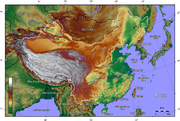
The Yunnan-Guizhou Plateau or Yungui Plateau is a plateau located in Yunnan
Yunnan
Yunnan is a province of the People's Republic of China, located in the far southwest of the country spanning approximately and with a population of 45.7 million . The capital of the province is Kunming. The province borders Burma, Laos, and Vietnam.Yunnan is situated in a mountainous area, with...
and Guizhou
Guizhou
' is a province of the People's Republic of China located in the southwestern part of the country. Its provincial capital city is Guiyang.- History :...
provinces in Southwestern China. There are two distinct areas of this plateau: an area of high plateau averaging about 2,000 m with mountain peaks as high as 3,700 m in northern Yunnan
Yunnan
Yunnan is a province of the People's Republic of China, located in the far southwest of the country spanning approximately and with a population of 45.7 million . The capital of the province is Kunming. The province borders Burma, Laos, and Vietnam.Yunnan is situated in a mountainous area, with...
province, and an area of rolling hills, deep river-carved gorges, and mountains marked with geologic fault
Geologic fault
In geology, a fault is a planar fracture or discontinuity in a volume of rock, across which there has been significant displacement along the fractures as a result of earth movement. Large faults within the Earth's crust result from the action of tectonic forces...
s in western Guizhou
Guizhou
' is a province of the People's Republic of China located in the southwestern part of the country. Its provincial capital city is Guiyang.- History :...
province. Easily eroded limestone
Limestone
Limestone is a sedimentary rock composed largely of the minerals calcite and aragonite, which are different crystal forms of calcium carbonate . Many limestones are composed from skeletal fragments of marine organisms such as coral or foraminifera....
underlies the plateau, allowing for spectacular karst
KARST
Kilometer-square Area Radio Synthesis Telescope is a Chinese telescope project to which FAST is a forerunner. KARST is a set of large spherical reflectors on karst landforms, which are bowlshaped limestone sinkholes named after the Kras region in Slovenia and Northern Italy. It will consist of...
s.
Temperature
Due to its high elevation and low latitude, the climate of the plateau is subject to intense solar radiation and cool temperatures with a large daily fluctuation and little yearly variation. The climate is divided in to dry and wet seasons. Overall, the description of the climate is complicated on the Plateau as the temperature varies from place to place. The height of the Plateau accounts for approximately one-third of the troposphereTroposphere
The troposphere is the lowest portion of Earth's atmosphere. It contains approximately 80% of the atmosphere's mass and 99% of its water vapor and aerosols....
on earth due to its high elevation, since as height rises, troposphere drops. For every 100 meter rise, in general there is a 0.6 degree C fall in temperature. In north Tibet the atmospheric temperatures are in closed temperature isolines showing the distinct impact of high elevation on temperature.
Glaciers
During the QuaternaryQuaternary
The Quaternary Period is the most recent of the three periods of the Cenozoic Era in the geologic time scale of the ICS. It follows the Neogene Period, spanning 2.588 ± 0.005 million years ago to the present...
there have been alternating glacial and interglacial
Interglacial
An Interglacial period is a geological interval of warmer global average temperature lasting thousands of years that separates consecutive glacial periods within an ice age...
periods, four glacial periods and three interglacial. The North Tibet Plateau are large areas of permafrost
Permafrost
In geology, permafrost, cryotic soil or permafrost soil is soil at or below the freezing point of water for two or more years. Ice is not always present, as may be in the case of nonporous bedrock, but it frequently occurs and it may be in amounts exceeding the potential hydraulic saturation of...
The Quinghai-Tibet Plateau is still in a glacial period.
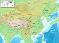
Rivers
The many high mountain peaks on Yunnan-Guizhou Plateau are the source of many of AsiaAsia
Asia is the world's largest and most populous continent, located primarily in the eastern and northern hemispheres. It covers 8.7% of the Earth's total surface area and with approximately 3.879 billion people, it hosts 60% of the world's current human population...
's great rivers. Some merge and become great rivers flowing into the sea, while others empty into inland lakes. Rivers from the southeast include the Yangtze and Yellow
Yellow
Yellow is the color evoked by light that stimulates both the L and M cone cells of the retina about equally, with no significant stimulation of the S cone cells. Light with a wavelength of 570–590 nm is yellow, as is light with a suitable mixture of red and green...
rivers and the upper reaches of the Brahmaputra River
Brahmaputra River
The Brahmaputra , also called Tsangpo-Brahmaputra, is a trans-boundary river and one of the major rivers of Asia. It is the only Indian river that is attributed the masculine gender and thus referred to as a in Indo-Aryan languages and languages with Indo-Aryan influence...
known as the Tongtian River
Tongtian River
The Tongtian River is a section of the Yangtze River within China's Qinghai Province. . It is one of the...
, Garmalequ, Shiquan, Yarlung Tsangpo and Nyang River
Nyang River
The Nyang River is a major river in south-west Tibet and the longest tributary of the Yarlung Tsangpo river....
s and Lancang rivers. To the north are rivers that begin in glaciers and flow into inland lakes or dry inland basins
Depression (geology)
A depression in geology is a landform sunken or depressed below the surrounding area. Depressions may be formed by various mechanisms.Structural or tectonic related:...
.
Lakes
The Tibetan PlateauTibetan Plateau
The Tibetan Plateau , also known as the Qinghai–Tibetan Plateau is a vast, elevated plateau in Central Asia covering most of the Tibet Autonomous Region and Qinghai, in addition to smaller portions of western Sichuan, southwestern Gansu, and northern Yunnan in Western China and Ladakh in...
(Qinghai-Tibet Plateau) is one of the areas with the most lakes in China
Lakes in China
Lakes in China include:See also:*Lake Tianchi Monster-External links:**http://www.hceis.com/ChinaBasic/Lakes/Lakes%20of%20China.htm...
of all sizes and descriptions. Most of the lakes are clustered. A lake usually lies in a depression
Depression (geology)
A depression in geology is a landform sunken or depressed below the surrounding area. Depressions may be formed by various mechanisms.Structural or tectonic related:...
or basin
Depression (geology)
A depression in geology is a landform sunken or depressed below the surrounding area. Depressions may be formed by various mechanisms.Structural or tectonic related:...
. The Tibet Autonomous Region has more than 1,500 lakes alone. The largest inland lake is the Nam Co, followed by Seling Co
Siling Co
Sêling Co is a lake in central Tibet on the Tibetan plateau. Doijiang is located near the lake.The lake lies at an altitude of 4530 meters. It is a salt lake. It is fed by the rivers Za'gya Zangbo and the Boques Tsangpo ....
and Zhari Nam Co.
Flora
The climate is rainy in the southwest in the summer, providing for dense forests, both broadleaf and coniferous. The shrubbery is varied from needles bush thicketsNeedle Bush
Vachellia farnesiana, also known as Acacia farnesiana, commonly known as Needle Bush, is so named because of the numerous thorns distributed along its branches. The native range of V. farnesiana is uncertain. While the point of origin is Mexico and Central America the species has a pantropical...
to acacia
Acacia
Acacia is a genus of shrubs and trees belonging to the subfamily Mimosoideae of the family Fabaceae, first described in Africa by the Swedish botanist Carl Linnaeus in 1773. Many non-Australian species tend to be thorny, whereas the majority of Australian acacias are not...
bushes growing in dry river beds. It is grassy marshland in the Tibet Autonomous Region
Tibet Autonomous Region
The Tibet Autonomous Region , Tibet or Xizang for short, also called the Xizang Autonomous Region is a province-level autonomous region of the People's Republic of China , created in 1965....
.