
Ill Bell
Encyclopedia
Ill Bell is a fell
in the English
Lake District
, in the county of Cumbria
, standing on the narrow ridge between the valleys of Kentmere
and Troutbeck.
, a strikingly similar lesser copy, while the adjoining fell to the south is Yoke
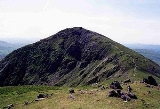
. Ill Bell appears from some directions to be a perfectly symmetrical bell-shaped peak, and 'Hill Bell' is one possible derivation of the name, quoted by Alfred Wainwright
. With this form aped by Froswick, the ridge assumes an unmistakable 'roller-coaster' appearance when viewed in profile.
The western side is steep and relatively smooth, falling not direct to the Troutbeck valley but to its main tributary, Hagg Gill. The low top of Troutbeck Tongue
stands between the two valleys. The eastern Kentmere flank is rougher and steeper, falling in a great tumble of scree to the shore of Kentmere Reservoir. There is the hint of a ridge to the north east over Leads Howe. North and south of Ill Bell the Kentmere face is gouged out by Over and Rainsborrow Coves respectively. These features have created the narrow ridges to Froswick and Yoke.
. A number of columnar cairn
s have been built at the summit and at various points close by. These are big enough to enable easy recognition of the fell from a distance. The view of the Scafells
is good and Ill Bell also gives a fine view of Windermere
.
Fell
“Fell” is a word used to refer to mountains, or certain types of mountainous landscape, in Scandinavia, the Isle of Man, and parts of northern England.- Etymology :...
in the English
England
England is a country that is part of the United Kingdom. It shares land borders with Scotland to the north and Wales to the west; the Irish Sea is to the north west, the Celtic Sea to the south west, with the North Sea to the east and the English Channel to the south separating it from continental...
Lake District
Lake District
The Lake District, also commonly known as The Lakes or Lakeland, is a mountainous region in North West England. A popular holiday destination, it is famous not only for its lakes and its mountains but also for its associations with the early 19th century poetry and writings of William Wordsworth...
, in the county of Cumbria
Cumbria
Cumbria , is a non-metropolitan county in North West England. The county and Cumbria County Council, its local authority, came into existence in 1974 after the passage of the Local Government Act 1972. Cumbria's largest settlement and county town is Carlisle. It consists of six districts, and in...
, standing on the narrow ridge between the valleys of Kentmere
Kentmere
Kentmere is a valley, village and civil parish in the Lake District National Park, a few miles from Kendal in the South Lakeland district of Cumbria, England. It is historically part of Westmorland...
and Troutbeck.
Topography
To the north is FroswickFroswick
Froswick is a fell in the English Lake District, standing on the fine narrow ridge between the valleys of Kentmere and Troutbeck.-Topography:To the north is Thornthwaite Crag, while the adjoining fell to the south is Ill Bell. Froswick is shorter in stature than either of its neighbours and also...
, a strikingly similar lesser copy, while the adjoining fell to the south is Yoke
Yoke (Lake District)
Yoke is a fell in the Lake District in Cumbria, England. It has a height of 706 m and is situated in the far eastern sector of the national park, 7 kilometres north east of the town of Ambleside. Yoke is the southern extremity of the long ridge that runs southwards from the fell of High...
. Ill Bell appears from some directions to be a perfectly symmetrical bell-shaped peak, and 'Hill Bell' is one possible derivation of the name, quoted by Alfred Wainwright
Alfred Wainwright
Alfred Wainwright MBE was a British fellwalker, guidebook author and illustrator. His seven-volume Pictorial Guide to the Lakeland Fells, published between 1955 and 1966 and consisting entirely of reproductions of his manuscript, has become the standard reference work to 214 of the fells of the...
. With this form aped by Froswick, the ridge assumes an unmistakable 'roller-coaster' appearance when viewed in profile.
The western side is steep and relatively smooth, falling not direct to the Troutbeck valley but to its main tributary, Hagg Gill. The low top of Troutbeck Tongue
Troutbeck Tongue
Troutbeck Tongue is a small fell located in the English Lake District, three miles east of Ambleside. It is one of 214 hills listed in Alfred Wainwright's Pictorial Guides to the Lakeland Fells, which makes it a popular attraction for walkers who are aiming to complete all the "Wainwrights"...
stands between the two valleys. The eastern Kentmere flank is rougher and steeper, falling in a great tumble of scree to the shore of Kentmere Reservoir. There is the hint of a ridge to the north east over Leads Howe. North and south of Ill Bell the Kentmere face is gouged out by Over and Rainsborrow Coves respectively. These features have created the narrow ridges to Froswick and Yoke.
Ascents
The ridge is followed by a good path, and is the most usual route of ascent. Yoke and Ill Bell form the start of the popular Kentmere Horseshoe, returning ultimately down the ridge on the opposite side of Kentmere valley. The ridge is also commonly ascended from Troutbeck valley, via the Garburn Road. Direct ascents are also possible from the valley of Hagg Gill via the northernmost quarry, or striking up over Lead Howes from the reservoir in Kentmere.Summit and view
The top of Ill Bell is small, peaked, and unusually stony for the Far Eastern FellsFar Eastern Fells
The Far Eastern Fells are a group of hills in the English Lake District. Reaching their highest point at High Street they occupy a broad area to the east of Ullswater and Kirkstone Pass. Much quieter than the central areas of Lakeland they offer in general easier but less exciting walking as the...
. A number of columnar cairn
Cairn
Cairn is a term used mainly in the English-speaking world for a man-made pile of stones. It comes from the or . Cairns are found all over the world in uplands, on moorland, on mountaintops, near waterways and on sea cliffs, and also in barren desert and tundra areas...
s have been built at the summit and at various points close by. These are big enough to enable easy recognition of the fell from a distance. The view of the Scafells
Scafell Pike
Scafell Pike is the highest mountain in England at . It is located in Lake District National Park sometimes confused with the neighbouring Sca Fell, to which it is connected by the col of Mickledore...
is good and Ill Bell also gives a fine view of Windermere
Windermere (lake)
Windermere is the largest natural lake in England. It is a ribbon lake formed in a glacial trough after the retreat of ice at the start of the current interglacial. It has been one of the country’s most popular places for holidays and summer homes since the arrival of the Kendal and Windermere...
.