
.gif)
Yellow River (Indiana)
Encyclopedia
Tributary
A tributary or affluent is a stream or river that flows into a main stem river or a lake. A tributary does not flow directly into a sea or ocean...
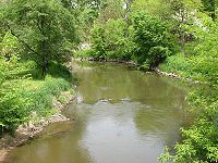
of the Kankakee River
Kankakee River
The Kankakee River is a tributary of the Illinois River, approximately long, in northwestern Indiana and northeastern Illinois in the United States. At one time the river drained one of the largest wetlands in North America and furnished a significant portage between the Great Lakes and the...
in northern Indiana
Indiana
Indiana is a US state, admitted to the United States as the 19th on December 11, 1816. It is located in the Midwestern United States and Great Lakes Region. With 6,483,802 residents, the state is ranked 15th in population and 16th in population density. Indiana is ranked 38th in land area and is...
in the United States
United States
The United States of America is a federal constitutional republic comprising fifty states and a federal district...
. Via the Kankakee and Illinois
Illinois River
The Illinois River is a principal tributary of the Mississippi River, approximately long, in the State of Illinois. The river drains a large section of central Illinois, with a drainage basin of . This river was important among Native Americans and early French traders as the principal water route...
rivers, it is part of the watershed
Drainage basin
A drainage basin is an extent or an area of land where surface water from rain and melting snow or ice converges to a single point, usually the exit of the basin, where the waters join another waterbody, such as a river, lake, reservoir, estuary, wetland, sea, or ocean...
of the Mississippi River
Mississippi River
The Mississippi River is the largest river system in North America. Flowing entirely in the United States, this river rises in western Minnesota and meanders slowly southwards for to the Mississippi River Delta at the Gulf of Mexico. With its many tributaries, the Mississippi's watershed drains...
, draining an area of 427 square miles (1,105.9 km²). The river's name possibly derives from a translation of the Shawnee
Shawnee language
The Shawnee language is a Central Algonquian language spoken in parts of central and northeastern Oklahoma by only around 200 Shawnee, making it an endangered language. It was originally spoken in Ohio, West Virginia, Kentucky, and Pennsylvania...
name for the river, We-thau-ka-mik, meaning "yellow waters", a description perhaps owing to the presence of sand
Sand
Sand is a naturally occurring granular material composed of finely divided rock and mineral particles.The composition of sand is highly variable, depending on the local rock sources and conditions, but the most common constituent of sand in inland continental settings and non-tropical coastal...
in the riverbed.
Course
Significant portions of the Yellow River's course have been straightened and channelized; the river's present-day course is considered to begin at a confluence of agricultural ditches in southeastern St. Joseph CountySt. Joseph County, Indiana
As of the census of 2000, there were 265,559 people, 100,743 households, and 66,792 families residing in the county. The population density was 581 people per square mile . There were 107,013 housing units at an average density of 234 per square mile...
, approximately 4 miles (6 km) north of the town of Bremen
Bremen, Indiana
Bremen is a town in German Township, Marshall County, Indiana, United States. The population was 4,588 at the 2010 census.-Geography:Bremen is located at...
. The river initially flows southwardly into Marshall County
Marshall County, Indiana
As of the census of 2000, there were 45,128 people, 16,519 households, and 12,191 families residing in the county. The population density was 102 people per square mile . There were 18,099 housing units at an average density of 41 per square mile...
, past Bremen; then generally southwestwardly, returning to its naturally winding riverbed and flowing through the city of Plymouth
Plymouth, Indiana
-Demographics:As of the census of 2000, there were 9,840 people, 3,838 households, and 2,406 families residing in the city. The population density was 1,414.0 people per square mile . There were 4,100 housing units at an average density of 589.2 per square mile...
; and westwardly in a substantially straightened course through Starke County
Starke County, Indiana
Starke County is a county located in the U.S. state of Indiana. As of 2010, the population was 23,363. The county seat is Knox.-History:Starke County was created in 1835 and organized in 1850. It was named for Gen...
, past the city of Knox
Knox, Indiana
Knox is a city in Center Township, Starke County, Indiana, United States. The population was 3,704 at the 2010 census. Knox is also within the Chicago Metropolitan Area along with the City of Valparaiso. The city is the county seat of Starke County. The city was founded in 1851 and is named after...
. It flows into the Kankakee River in southwestern Starke County, approximately 10 miles (16.1 km) west of Knox.
Watershed
The Yellow River is bounded by the St. Joseph RiverSt. Joseph River (Lake Michigan)
The St. Joseph River is a river, approximately long, in southern Michigan and northern Indiana in the United States. It drains a primarily rural farming area in the watershed of Lake Michigan...
of Lake Michigan on the north, flowing through Elkhart
Elkhart, Indiana
Elkhart is a city in Elkhart County, Indiana, United States. The city is located east of South Bend, northwest of Fort Wayne, east of Chicago, and north of Indianapolis...
, Mishawaka
Mishawaka, Indiana
Mishawaka is a city on the St. Joseph River and a Twin city of South Bend in St. Joseph County, Indiana, United States. The population was 48,252 as of the 2010 Census...
, and South Bend
South Bend, Indiana
The city of South Bend is the county seat of St. Joseph County, Indiana, United States, on the St. Joseph River near its southernmost bend, from which it derives its name. As of the 2010 Census, the city had a total of 101,168 residents; its Metropolitan Statistical Area had a population of 316,663...
. To the east is the Elkhart River
Elkhart River
The Elkhart River is a tributary of the St. Joseph River in northern Indiana in the United States. It is almost entirely contained in Elkhart County. It begins southeast of Millersburg just across the county line in Noble County. It flows generally westward through Benton and then turns...
, a branch of the St. Joseph, all flowing to Lake Michigan, through the lower lakes to the St. Lawrence River and reaching the North Atlantic. On the south and the southeast, it is bounded by the drainage of the Tippecanoe River
Tippecanoe River
The Tippecanoe River is a gentle, river in northern Indiana that flows from Big Lake in Noble County to the Wabash River near Battle Ground, about northeast of Lafayette. The name "Tippecanoe" comes from a Miami-Illinois word for buffalo fish, reconstructed as */kiteepihkwana/.The Tippecanoe...
. The Tippecanoe River flows southward into the Wabash River
Wabash River
The Wabash River is a river in the Midwestern United States that flows southwest from northwest Ohio near Fort Recovery across northern Indiana to southern Illinois, where it forms the Illinois-Indiana border before draining into the Ohio River, of which it is the largest northern tributary...
, emptying into the Ohio, then into the Mississippi River
Mississippi River
The Mississippi River is the largest river system in North America. Flowing entirely in the United States, this river rises in western Minnesota and meanders slowly southwards for to the Mississippi River Delta at the Gulf of Mexico. With its many tributaries, the Mississippi's watershed drains...
, expelling its waters into the Gulf of Mexico
Gulf of Mexico
The Gulf of Mexico is a partially landlocked ocean basin largely surrounded by the North American continent and the island of Cuba. It is bounded on the northeast, north and northwest by the Gulf Coast of the United States, on the southwest and south by Mexico, and on the southeast by Cuba. In...
. To the southwest is the Iroquois River
Iroquois River
The Iroquois River is a tributary of the Kankakee River in northwestern Indiana and northeastern Illinois in the United States. Via the Kankakee and Illinois rivers, it is part of the watershed of the Mississippi River.-Course:...
a tributary of the Kankakee River
Kankakee River
The Kankakee River is a tributary of the Illinois River, approximately long, in northwestern Indiana and northeastern Illinois in the United States. At one time the river drained one of the largest wetlands in North America and furnished a significant portage between the Great Lakes and the...
, as is the Yellow River. The Yellow River is the second-largest tributary of the Kankakee. The Iroquois River is larger and joins the Kankakee across the border in Illinois. The Kankakee River joins the Des Plaines River
Des Plaines River
The Des Plaines River is a river that flows southward for through southern Wisconsin and northern Illinois in the U.S. Midwest, eventually meeting the Kankakee River west of Channahon to form the Illinois River, a tributary of the Mississippi River....
south of Joliet, Illinois
Joliet, Illinois
Joliet is a city in Will and Kendall Counties in the U.S. state of Illinois, located southwest of Chicago. It is the county seat of Will County. As of the 2010 census, the city was the fourth-most populated in Illinois, with a population of 147,433. It continues to be Illinois' fastest growing...
, forming the Illinois River
Illinois River
The Illinois River is a principal tributary of the Mississippi River, approximately long, in the State of Illinois. The river drains a large section of central Illinois, with a drainage basin of . This river was important among Native Americans and early French traders as the principal water route...
. Together they flow the length of the state of Illinois
Illinois
Illinois is the fifth-most populous state of the United States of America, and is often noted for being a microcosm of the entire country. With Chicago in the northeast, small industrial cities and great agricultural productivity in central and northern Illinois, and natural resources like coal,...
before joining the Mississippi River
Mississippi River
The Mississippi River is the largest river system in North America. Flowing entirely in the United States, this river rises in western Minnesota and meanders slowly southwards for to the Mississippi River Delta at the Gulf of Mexico. With its many tributaries, the Mississippi's watershed drains...
, north of St. Louis
St. Louis, Missouri
St. Louis is an independent city on the eastern border of Missouri, United States. With a population of 319,294, it was the 58th-largest U.S. city at the 2010 U.S. Census. The Greater St...
.
Potawatomi
Main PocMain Poc
Main Poc was a leader of the Yellow River villages of the Potawatomi native Americans in the United States...
was a warrior and chief among the Yellow River Potawatomi first coming to notice at the Treaty of Greenville (July 1795), which was to bring peace to the frontier. Within a year, Main Poc was leading raiding parties across the Mississippi into Spanish Territory. By 1804, Main Poc and Turkey Foot were raiding throughout the Midwest and deep into Tennessee
Tennessee
Tennessee is a U.S. state located in the Southeastern United States. It has a population of 6,346,105, making it the nation's 17th-largest state by population, and covers , making it the 36th-largest by total land area...
and Kentucky
Kentucky
The Commonwealth of Kentucky is a state located in the East Central United States of America. As classified by the United States Census Bureau, Kentucky is a Southern state, more specifically in the East South Central region. Kentucky is one of four U.S. states constituted as a commonwealth...
. When the reached across the Mississippi to attack the Osage in what had become the U.S.’s Louisiana Territory
Louisiana Territory
The Territory of Louisiana or Louisiana Territory was an organized incorporated territory of the United States that existed from July 4, 1805 until June 4, 1812, when it was renamed to Missouri Territory...
, the American military called for a council. Main Poc and Turkey Foot did not attend and kept traveling out of their Yellow River communities to raid other Indian villages. Soon other Potawatomi villages were taking after Main Poc and raiding elsewhere. In 1807, Tecumseh
Tecumseh
Tecumseh was a Native American leader of the Shawnee and a large tribal confederacy which opposed the United States during Tecumseh's War and the War of 1812...
and his brother, the prophet came to Indiana and Main Poc joined in his plans to hold back the white settlers. With Main Poc’s move to Prophetstown
Prophetstown
Prophetstown may refer toIn Illinois, USA:* Prophetstown, Illinois* Prophetstown Township, Whiteside County, Illinois* Prophetstown State Recreation AreaIn Indiana, USA:...
in 1809, the Yellow River was no longer the seat of war among the Potawatomis. After the defeat of Tecumseh at the Battle of Tippecanoe
Battle of Tippecanoe
The Battle of Tippecanoe was fought on November 7, 1811, between United States forces led by Governor William Henry Harrison of the Indiana Territory and Native American warriors associated with the Shawnee leader Tecumseh. Tecumseh and his brother Tenskwatawa were leaders of a confederacy of...
and then at the Battle of the Thames
Battle of the Thames
The Battle of the Thames, also known as the Battle of Moraviantown, was a decisive American victory in the War of 1812. It took place on October 5, 1813, near present-day Chatham, Ontario in Upper Canada...
(October 5, 1813), peace returned to northern Indiana. Main Poc returned to the Yellow River after the 1814 Treaty of Greenville. His new village was between Plymouth and Knox. In 1816 he died, leaving the pro-American Chiefs firmly in place.
By 1814, Menominee was a prominent leader of the Twin Lakes Potawatomi. He had become known to the Indian Agents as early as 1791 as a leader among the Twin Lakes Potawatomi. In 1820 he got Isaac McCoy
Isaac McCoy
Isaac McCoy was a Baptist missionary among the Native Americans in present-day Indiana, Michigan and Missouri. He was an advocate of Indian removal from the eastern United States, proposing an Indian state in what is now Kansas, Nebraska, and Oklahoma...
, a Protestant Missionary to come to the Yellow River. Menominee was a religious chief and he planned to combine the teaching of Tecumseh
Tecumseh
Tecumseh was a Native American leader of the Shawnee and a large tribal confederacy which opposed the United States during Tecumseh's War and the War of 1812...
and the Prophet with Roman Catholicism. He was seeking a way for his people to cope with the growing number of settlers. The Carey Mission was established on the St. Joseph River
St. Joseph River (Lake Michigan)
The St. Joseph River is a river, approximately long, in southern Michigan and northern Indiana in the United States. It drains a primarily rural farming area in the watershed of Lake Michigan...
, north of the Twin Lakes in the area where Niles, Michigan
Niles, Michigan
Niles is a city in Berrien and Cass counties in the U.S. state of Michigan, near South Bend, Indiana. The population was 11,600 at the 2010 census. It is the greater populated of two principal cities of and included in the Niles-Benton Harbor, Michigan Metropolitan Statistical Area, which has a...
now stands. In the 1830s, Carey’s mission declined and was replace by a Roman Catholic Mission. In 1833, the fathers expanded their mission to the Yellow River Potawatomi. These two communities would be the heart of the resistance to removal.
By 1830, there were three substantial Potawatomi villages on the Yellow River, each with its own chief. Notawkah (Rattlesnake) was the leader of the village east of the Yellow River, south of Plymouth. He moved to Kansas when chief Menominee refused to leave Indiana in 1837. Mackahtahmoah (Black Wolf) was chief of the western village, near the Starke and Marshall county lines. Pepinawah was another chief among these villages.
In 1832, during the Indian removal
Indian Removal
Indian removal was a nineteenth century policy of the government of the United States to relocate Native American tribes living east of the Mississippi River to lands west of the river...
period, a group of Potawatomi
Potawatomi
The Potawatomi are a Native American people of the upper Mississippi River region. They traditionally speak the Potawatomi language, a member of the Algonquian family. In the Potawatomi language, they generally call themselves Bodéwadmi, a name that means "keepers of the fire" and that was applied...
chiefs signed a treaty with the U.S. government setting aside for the Potawatomi in perpetuity an area of 14,000 acres (57 km²) in the vicinity of the Yellow River; this land was sold at the 1836 Treaty of Yellow River, signed by three Potawatomi chiefs, which stipulated that all Potawatomi move west of the Mississippi River within two years.
Chief Menominee refused to sign any treaty, which gave away Indian lands. Still, the land was taken by the Treaty of Tippecanoe
Treaty of Tippecanoe
The Treaty of Tippecanoe was an agreement between the United States government and Native American tribes in Indiana on October 26, 1832.-Treaty:...
. When the Potawatomi of Indiana were being rounded up for transportation to the west, Menominee’s village became the gathering place of those who did not agree to go. When Menominee again refused to allow his village to be removed by August 6, 1838, the reservation was opened to squatters. When the Potawatomi
Potawatomi
The Potawatomi are a Native American people of the upper Mississippi River region. They traditionally speak the Potawatomi language, a member of the Algonquian family. In the Potawatomi language, they generally call themselves Bodéwadmi, a name that means "keepers of the fire" and that was applied...
destroyed the huts of squatters, the whites retaliated by burning the Indians cabins. In an attempt to prevent bloodshed, Governor David Wallace of Indiana
Indiana
Indiana is a US state, admitted to the United States as the 19th on December 11, 1816. It is located in the Midwestern United States and Great Lakes Region. With 6,483,802 residents, the state is ranked 15th in population and 16th in population density. Indiana is ranked 38th in land area and is...
authorized the enlistment of volunteers. Menominee was lured to a meeting to allow for the militia to surround his village and take the Potawatomi into custody. On September 4, 1838, the Potawatomi of Indiana began their march to Kansas
Kansas
Kansas is a US state located in the Midwestern United States. It is named after the Kansas River which flows through it, which in turn was named after the Kansa Native American tribe, which inhabited the area. The tribe's name is often said to mean "people of the wind" or "people of the south...
, the Trail of Death. Menominee's band of 859 people were forcibly removed to Kansas in 1838, in an event known as the Potawatomi Trail of Death
Potawatomi Trail of Death
The Potawatomi Trail of Death was the forced removal by United States forces from September 4 to November 4, 1838, of 859 members of the Potawatomi nation from Twin Lakes near Plymouth, Indiana, to the location of present-day Osawatomie, Kansas, a distance of . Typhoid fever and the stress of the...
.
River engineering
At the time of European settlement, the area of the confluence of the Yellow and Kankakee Rivers was a densely vegetated marsh, seven miles (11 km) long, known as English Lake. The lower Yellow River was confined to a straightened channel and the wetland was drained and converted to farmland by the 1910s. A spit of land between the straightened Yellow and Kankakee channels was established by the state of Indiana as the Kankakee State Fish and Wildlife Area in 1933 and converted back to marshland.The straightened section of the Yellow River in Starke County, which had historically been a swampy and winding stream with numerous oxbow lake
Oxbow lake
An oxbow lake is a U-shaped body of water formed when a wide meander from the main stem of a river is cut off to create a lake. This landform is called an oxbow lake for the distinctive curved shape, named after part of a yoke for oxen. In Australia, an oxbow lake is called a billabong, derived...
s, was the subject of a 2004 effort by the United States Army Corps of Engineers
United States Army Corps of Engineers
The United States Army Corps of Engineers is a federal agency and a major Army command made up of some 38,000 civilian and military personnel, making it the world's largest public engineering, design and construction management agency...
to address excess accumulation of sediment in the river's streambed as a result of channelization.
Towns and cities
- PlymouthPlymouth, Indiana-Demographics:As of the census of 2000, there were 9,840 people, 3,838 households, and 2,406 families residing in the city. The population density was 1,414.0 people per square mile . There were 4,100 housing units at an average density of 589.2 per square mile...
- KnoxKnox, IndianaKnox is a city in Center Township, Starke County, Indiana, United States. The population was 3,704 at the 2010 census. Knox is also within the Chicago Metropolitan Area along with the City of Valparaiso. The city is the county seat of Starke County. The city was founded in 1851 and is named after...
- English LakeEnglish Lake, IndianaEnglish Lake is an unincorporated community in Starke County, Indiana, United States, located along the Kankakee River. It is a small community of only a few hundred individuals. It is named for English Lake, which once existed at the junction of the Yellow River with the Kankakee...