
Yellow Bank River
Encyclopedia
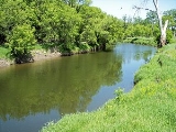
The Yellow Bank River is a tributary
of the Minnesota River
, approximately nine miles (14 km) long, in western Minnesota
in the United States
. It is formed by the confluence of two longer streams, the North Fork Yellow Bank River and the South Fork Yellow Bank River, which also flow in northeastern South Dakota
. Via the Minnesota River, the Yellow Bank River is part of the watershed
of the Mississippi River
, draining an area of approximately 460 square miles (1,190 km²) in an agricultural region.
The river was named for yellowish glacial drift
in bluffs along the river. Its name was translated from the Sioux language
as "Spirit Mountain Creek" by William Keating in his account of Stephen Harriman Long
's expedition to the region in 1823. It was labelled as "Yellow Earth River" on an 1860 map of Minnesota.
, a morainic
plateau
dividing the Mississippi and Missouri River
watersheds, and flow across till plain
s into Minnesota. The north fork issues from Round Lake near South Shore
in northeastern Codington County, South Dakota
, and flows eastwardly for approximately fifty miles (80 km) through central Grant County
into northwestern Lac qui Parle County, Minnesota
. The south fork rises in northwestern Deuel County, South Dakota
, approximately six miles (10 km) southwest of Strandburg
, and flows generally northeastwardly for approximately 55 miles (90 km) through southern Grant County and western Lac qui Parle County, passing near the community of Nassau, Minnesota
. From the confluence of the forks in Yellow Bank Township, Minnesota
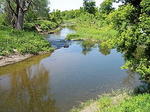
, the Yellow Bank River flows northwardly for its short course, passing through the Big Stone National Wildlife Refuge
, and entering the Minnesota River in Agassiz Township
, approximately three miles (5 km) southeast of Odessa
. In the Big Stone refuge, the river flows among woodlands of American elm
, ash
, box elder
, and silver maple, and may be fished.
's stream gauge
in Agassiz Township south of Odessa, 4.5 miles (7.2 km) upstream from the river's mouth, the annual mean flow of the river between 1940 and 2005 was 69.3 cubic feet per second (2 m³/s). The highest recorded flow during the period was 6,940 ft³/s (197 m³/s) on April 9, 1969. Readings of zero were recorded on numerous days during several years.
The Yellow Bank River is a tributary
of the Minnesota River
, approximately nine miles (14 km) long, in western Minnesota
in the United States
. It is formed by the confluence of two longer streams, the North Fork Yellow Bank River and the South Fork Yellow Bank River, which also flow in northeastern South Dakota
. Via the Minnesota River, the Yellow Bank River is part of the watershed
of the Mississippi River
, draining an area of approximately 460 square miles (1,190 km²) in an agricultural region.
The river was named for yellowish glacial drift
in bluffs along the river. Its name was translated from the Sioux language
as "Spirit Mountain Creek" by William Keating in his account of Stephen Harriman Long
's expedition to the region in 1823. It was labelled as "Yellow Earth River" on an 1860 map of Minnesota.
, a morainic
plateau
dividing the Mississippi and Missouri River
watersheds, and flow across till plain
s into Minnesota. The north fork issues from Round Lake near South Shore
in northeastern Codington County, South Dakota
, and flows eastwardly for approximately fifty miles (80 km) through central Grant County
into northwestern Lac qui Parle County, Minnesota
. The south fork rises in northwestern Deuel County, South Dakota
, approximately six miles (10 km) southwest of Strandburg
, and flows generally northeastwardly for approximately 55 miles (90 km) through southern Grant County and western Lac qui Parle County, passing near the community of Nassau, Minnesota
. From the confluence of the forks in Yellow Bank Township, Minnesota
, the Yellow Bank River flows northwardly for its short course, passing through the Big Stone National Wildlife Refuge
, and entering the Minnesota River in Agassiz Township
, approximately three miles (5 km) southeast of Odessa
. In the Big Stone refuge, the river flows among woodlands of American elm
, ash
, box elder
, and silver maple, and may be fished.
's stream gauge
in Agassiz Township south of Odessa, 4.5 miles (7.2 km) upstream from the river's mouth, the annual mean flow of the river between 1940 and 2005 was 69.3 cubic feet per second (2 m³/s). The highest recorded flow during the period was 6,940 ft³/s (197 m³/s) on April 9, 1969. Readings of zero were recorded on numerous days during several years.
|accessdate=2007-06-16}} |title=Geographic Names Information System entry for South Fork Yellow Bank River (Feature ID #652306) |publisher=Geographic Names Information System
|accessdate=2007-06-16}} |title=Geographic Names Information System entry for Yellow Bank River (Feature ID #654414) |publisher=Geographic Names Information System
|accessdate=2007-06-16}}
Tributary
A tributary or affluent is a stream or river that flows into a main stem river or a lake. A tributary does not flow directly into a sea or ocean...
of the Minnesota River
Minnesota River
The Minnesota River is a tributary of the Mississippi River, approximately 332 miles long, in the U.S. state of Minnesota. It drains a watershed of nearly , in Minnesota and about in South Dakota and Iowa....
, approximately nine miles (14 km) long, in western Minnesota
Minnesota
Minnesota is a U.S. state located in the Midwestern United States. The twelfth largest state of the U.S., it is the twenty-first most populous, with 5.3 million residents. Minnesota was carved out of the eastern half of the Minnesota Territory and admitted to the Union as the thirty-second state...
in the United States
United States
The United States of America is a federal constitutional republic comprising fifty states and a federal district...
. It is formed by the confluence of two longer streams, the North Fork Yellow Bank River and the South Fork Yellow Bank River, which also flow in northeastern South Dakota
South Dakota
South Dakota is a state located in the Midwestern region of the United States. It is named after the Lakota and Dakota Sioux American Indian tribes. Once a part of Dakota Territory, South Dakota became a state on November 2, 1889. The state has an area of and an estimated population of just over...
. Via the Minnesota River, the Yellow Bank River is part of the watershed
Drainage basin
A drainage basin is an extent or an area of land where surface water from rain and melting snow or ice converges to a single point, usually the exit of the basin, where the waters join another waterbody, such as a river, lake, reservoir, estuary, wetland, sea, or ocean...
of the Mississippi River
Mississippi River
The Mississippi River is the largest river system in North America. Flowing entirely in the United States, this river rises in western Minnesota and meanders slowly southwards for to the Mississippi River Delta at the Gulf of Mexico. With its many tributaries, the Mississippi's watershed drains...
, draining an area of approximately 460 square miles (1,190 km²) in an agricultural region.
The river was named for yellowish glacial drift
Drift (geology)
In geology, drift is the name for all material of glacial origin found anywhere on land or at sea , including sediment and large rocks...
in bluffs along the river. Its name was translated from the Sioux language
Sioux language
Sioux is a Siouan language spoken by over 33,000 Sioux in the United States and Canada, making it the fifth most spoken indigenous language in the United States or Canada, behind Navajo, Cree, Inuit and Ojibwe.-Regional variation:...
as "Spirit Mountain Creek" by William Keating in his account of Stephen Harriman Long
Stephen Harriman Long
Stephen Harriman Long was a U.S. army explorer, topographical engineer, and railway engineer. As an inventor, he is noted for his developments in the design of steam locomotives. He was also one of the most prolific explorers of the early 1800s, although his career as an explorer was relatively...
's expedition to the region in 1823. It was labelled as "Yellow Earth River" on an 1860 map of Minnesota.
Geography
The river's north and south forks each rise in South Dakota on the Coteau des PrairiesCoteau des Prairies
The Coteau des Prairies is a plateau approximately 200 miles in length and 100 miles in width , rising from the prairie flatlands in eastern South Dakota, southwestern Minnesota, and northwestern Iowa in the United States...
, a morainic
Moraine
A moraine is any glacially formed accumulation of unconsolidated glacial debris which can occur in currently glaciated and formerly glaciated regions, such as those areas acted upon by a past glacial maximum. This debris may have been plucked off a valley floor as a glacier advanced or it may have...
plateau
Plateau
In geology and earth science, a plateau , also called a high plain or tableland, is an area of highland, usually consisting of relatively flat terrain. A highly eroded plateau is called a dissected plateau...
dividing the Mississippi and Missouri River
Missouri River
The Missouri River flows through the central United States, and is a tributary of the Mississippi River. It is the longest river in North America and drains the third largest area, though only the thirteenth largest by discharge. The Missouri's watershed encompasses most of the American Great...
watersheds, and flow across till plain
Till plain
A till plain is an extensive flat plain of glacial till that forms when a sheet of ice becomes detached from the main body of a glacier and melts in place depositing the sediments it carried. A till plain with irregular topography is referred to as a ground moraine.-See also:*Glacial till plains...
s into Minnesota. The north fork issues from Round Lake near South Shore
South Shore, South Dakota
South Shore is a town in Codington County, South Dakota, United States. The population was 227 at the 2010 census. It is part of the Watertown, South Dakota Micropolitan Statistical Area.-Geography:South Shore is located at ....
in northeastern Codington County, South Dakota
Codington County, South Dakota
As of the census of 2000, there were 25,897 people, 10,357 households, and 6,877 families residing in the county. The population density was 38 people per square mile . There were 11,324 housing units at an average density of 16 per square mile...
, and flows eastwardly for approximately fifty miles (80 km) through central Grant County
Grant County, South Dakota
As of the census of 2000, there were 7,847 people, 3,116 households, and 2,156 families residing in the county. The population density was 12 people per square mile . There were 3,456 housing units at an average density of 5 per square mile...
into northwestern Lac qui Parle County, Minnesota
Lac qui Parle County, Minnesota
As of the census of 2000, there were 8,067 people, 3,316 households, and 2,225 families residing in the county. The population density was 10 people per square mile . There were 3,774 housing units at an average density of 5 per square mile...
. The south fork rises in northwestern Deuel County, South Dakota
Deuel County, South Dakota
As of the census of 2000, there were 4,498 people, 1,843 households, and 1,258 families residing in the county. The population density was 7 people per square mile . There were 2,172 housing units at an average density of 4 per square mile...
, approximately six miles (10 km) southwest of Strandburg
Strandburg, South Dakota
Strandburg is a town in Grant County, South Dakota, United States. The population was 72 at the 2010 census. Its named is derived from the town's founder, the Swedish John Strandberg.-Geography:Strandburg is located at ....
, and flows generally northeastwardly for approximately 55 miles (90 km) through southern Grant County and western Lac qui Parle County, passing near the community of Nassau, Minnesota
Nassau, Minnesota
Nassau is a city in Lac qui Parle County, Minnesota, United States. The population was 72 at the 2010 census.-Geography:According to the United States Census Bureau, the city has a total area of 0.2 square miles , all of it land....
. From the confluence of the forks in Yellow Bank Township, Minnesota
Yellow Bank Township, Minnesota
Yellow Bank Township is a township in Lac qui Parle County, Minnesota, United States. The population was 177 at the 2000 census.-Geography:According to the United States Census Bureau, the township has a total area of 35.3 square miles , of which, 35.2 square miles of it is land and...
, the Yellow Bank River flows northwardly for its short course, passing through the Big Stone National Wildlife Refuge
Big Stone National Wildlife Refuge
Straddling the headwaters of the Minnesota River in extreme west-central Minnesota, Big Stone National Wildlife Refuge is within the heart of the tallgrass prairie's historic range...
, and entering the Minnesota River in Agassiz Township
Agassiz Township, Minnesota
Agassiz Township is a township in Lac qui Parle County, Minnesota, United States. The population was 104 at the 2000 census.-Geography:According to the United States Census Bureau, the township has a total area of , of which, of it is land and of it is water.-Demographics:As of the census of...
, approximately three miles (5 km) southeast of Odessa
Odessa, Minnesota
-References:...
. In the Big Stone refuge, the river flows among woodlands of American elm
American Elm
Ulmus americana, generally known as the American Elm or, less commonly, as the White Elm or Water Elm, is a species native to eastern North America, occurring from Nova Scotia west to Alberta and Montana, and south to Florida and central Texas. The American elm is an extremely hardy tree that can...
, ash
Ash tree
Fraxinus is a genus flowering plants in the olive and lilac family, Oleaceae. It contains 45-65 species of usually medium to large trees, mostly deciduous though a few subtropical species are evergreen. The tree's common English name, ash, goes back to the Old English æsc, while the generic name...
, box elder
Acer negundo
Acer negundo is a species of maple native to North America. Box Elder, Boxelder Maple, and Maple Ash are its most common names in the United States...
, and silver maple, and may be fished.
Flow rate
At the United States Geological SurveyUnited States Geological Survey
The United States Geological Survey is a scientific agency of the United States government. The scientists of the USGS study the landscape of the United States, its natural resources, and the natural hazards that threaten it. The organization has four major science disciplines, concerning biology,...
's stream gauge
Stream gauge
A stream gauge, stream gage or gauging station is a location used by hydrologists or environmental scientists to monitor and test terrestrial bodies of water. Hydrometric measurements of water surface elevation and/or volumetric discharge are generally taken and observations of biota may also be...
in Agassiz Township south of Odessa, 4.5 miles (7.2 km) upstream from the river's mouth, the annual mean flow of the river between 1940 and 2005 was 69.3 cubic feet per second (2 m³/s). The highest recorded flow during the period was 6,940 ft³/s (197 m³/s) on April 9, 1969. Readings of zero were recorded on numerous days during several years.
Sources
The Yellow Bank River is a tributary
Tributary
A tributary or affluent is a stream or river that flows into a main stem river or a lake. A tributary does not flow directly into a sea or ocean...
of the Minnesota River
Minnesota River
The Minnesota River is a tributary of the Mississippi River, approximately 332 miles long, in the U.S. state of Minnesota. It drains a watershed of nearly , in Minnesota and about in South Dakota and Iowa....
, approximately nine miles (14 km) long, in western Minnesota
Minnesota
Minnesota is a U.S. state located in the Midwestern United States. The twelfth largest state of the U.S., it is the twenty-first most populous, with 5.3 million residents. Minnesota was carved out of the eastern half of the Minnesota Territory and admitted to the Union as the thirty-second state...
in the United States
United States
The United States of America is a federal constitutional republic comprising fifty states and a federal district...
. It is formed by the confluence of two longer streams, the North Fork Yellow Bank River and the South Fork Yellow Bank River, which also flow in northeastern South Dakota
South Dakota
South Dakota is a state located in the Midwestern region of the United States. It is named after the Lakota and Dakota Sioux American Indian tribes. Once a part of Dakota Territory, South Dakota became a state on November 2, 1889. The state has an area of and an estimated population of just over...
. Via the Minnesota River, the Yellow Bank River is part of the watershed
Drainage basin
A drainage basin is an extent or an area of land where surface water from rain and melting snow or ice converges to a single point, usually the exit of the basin, where the waters join another waterbody, such as a river, lake, reservoir, estuary, wetland, sea, or ocean...
of the Mississippi River
Mississippi River
The Mississippi River is the largest river system in North America. Flowing entirely in the United States, this river rises in western Minnesota and meanders slowly southwards for to the Mississippi River Delta at the Gulf of Mexico. With its many tributaries, the Mississippi's watershed drains...
, draining an area of approximately 460 square miles (1,190 km²) in an agricultural region.
The river was named for yellowish glacial drift
Drift (geology)
In geology, drift is the name for all material of glacial origin found anywhere on land or at sea , including sediment and large rocks...
in bluffs along the river. Its name was translated from the Sioux language
Sioux language
Sioux is a Siouan language spoken by over 33,000 Sioux in the United States and Canada, making it the fifth most spoken indigenous language in the United States or Canada, behind Navajo, Cree, Inuit and Ojibwe.-Regional variation:...
as "Spirit Mountain Creek" by William Keating in his account of Stephen Harriman Long
Stephen Harriman Long
Stephen Harriman Long was a U.S. army explorer, topographical engineer, and railway engineer. As an inventor, he is noted for his developments in the design of steam locomotives. He was also one of the most prolific explorers of the early 1800s, although his career as an explorer was relatively...
's expedition to the region in 1823. It was labelled as "Yellow Earth River" on an 1860 map of Minnesota.
Geography
The river's north and south forks each rise in South Dakota on the Coteau des PrairiesCoteau des Prairies
The Coteau des Prairies is a plateau approximately 200 miles in length and 100 miles in width , rising from the prairie flatlands in eastern South Dakota, southwestern Minnesota, and northwestern Iowa in the United States...
, a morainic
Moraine
A moraine is any glacially formed accumulation of unconsolidated glacial debris which can occur in currently glaciated and formerly glaciated regions, such as those areas acted upon by a past glacial maximum. This debris may have been plucked off a valley floor as a glacier advanced or it may have...
plateau
Plateau
In geology and earth science, a plateau , also called a high plain or tableland, is an area of highland, usually consisting of relatively flat terrain. A highly eroded plateau is called a dissected plateau...
dividing the Mississippi and Missouri River
Missouri River
The Missouri River flows through the central United States, and is a tributary of the Mississippi River. It is the longest river in North America and drains the third largest area, though only the thirteenth largest by discharge. The Missouri's watershed encompasses most of the American Great...
watersheds, and flow across till plain
Till plain
A till plain is an extensive flat plain of glacial till that forms when a sheet of ice becomes detached from the main body of a glacier and melts in place depositing the sediments it carried. A till plain with irregular topography is referred to as a ground moraine.-See also:*Glacial till plains...
s into Minnesota. The north fork issues from Round Lake near South Shore
South Shore, South Dakota
South Shore is a town in Codington County, South Dakota, United States. The population was 227 at the 2010 census. It is part of the Watertown, South Dakota Micropolitan Statistical Area.-Geography:South Shore is located at ....
in northeastern Codington County, South Dakota
Codington County, South Dakota
As of the census of 2000, there were 25,897 people, 10,357 households, and 6,877 families residing in the county. The population density was 38 people per square mile . There were 11,324 housing units at an average density of 16 per square mile...
, and flows eastwardly for approximately fifty miles (80 km) through central Grant County
Grant County, South Dakota
As of the census of 2000, there were 7,847 people, 3,116 households, and 2,156 families residing in the county. The population density was 12 people per square mile . There were 3,456 housing units at an average density of 5 per square mile...
into northwestern Lac qui Parle County, Minnesota
Lac qui Parle County, Minnesota
As of the census of 2000, there were 8,067 people, 3,316 households, and 2,225 families residing in the county. The population density was 10 people per square mile . There were 3,774 housing units at an average density of 5 per square mile...
. The south fork rises in northwestern Deuel County, South Dakota
Deuel County, South Dakota
As of the census of 2000, there were 4,498 people, 1,843 households, and 1,258 families residing in the county. The population density was 7 people per square mile . There were 2,172 housing units at an average density of 4 per square mile...
, approximately six miles (10 km) southwest of Strandburg
Strandburg, South Dakota
Strandburg is a town in Grant County, South Dakota, United States. The population was 72 at the 2010 census. Its named is derived from the town's founder, the Swedish John Strandberg.-Geography:Strandburg is located at ....
, and flows generally northeastwardly for approximately 55 miles (90 km) through southern Grant County and western Lac qui Parle County, passing near the community of Nassau, Minnesota
Nassau, Minnesota
Nassau is a city in Lac qui Parle County, Minnesota, United States. The population was 72 at the 2010 census.-Geography:According to the United States Census Bureau, the city has a total area of 0.2 square miles , all of it land....
. From the confluence of the forks in Yellow Bank Township, Minnesota
Yellow Bank Township, Minnesota
Yellow Bank Township is a township in Lac qui Parle County, Minnesota, United States. The population was 177 at the 2000 census.-Geography:According to the United States Census Bureau, the township has a total area of 35.3 square miles , of which, 35.2 square miles of it is land and...
, the Yellow Bank River flows northwardly for its short course, passing through the Big Stone National Wildlife Refuge
Big Stone National Wildlife Refuge
Straddling the headwaters of the Minnesota River in extreme west-central Minnesota, Big Stone National Wildlife Refuge is within the heart of the tallgrass prairie's historic range...
, and entering the Minnesota River in Agassiz Township
Agassiz Township, Minnesota
Agassiz Township is a township in Lac qui Parle County, Minnesota, United States. The population was 104 at the 2000 census.-Geography:According to the United States Census Bureau, the township has a total area of , of which, of it is land and of it is water.-Demographics:As of the census of...
, approximately three miles (5 km) southeast of Odessa
Odessa, Minnesota
-References:...
. In the Big Stone refuge, the river flows among woodlands of American elm
American Elm
Ulmus americana, generally known as the American Elm or, less commonly, as the White Elm or Water Elm, is a species native to eastern North America, occurring from Nova Scotia west to Alberta and Montana, and south to Florida and central Texas. The American elm is an extremely hardy tree that can...
, ash
Ash tree
Fraxinus is a genus flowering plants in the olive and lilac family, Oleaceae. It contains 45-65 species of usually medium to large trees, mostly deciduous though a few subtropical species are evergreen. The tree's common English name, ash, goes back to the Old English æsc, while the generic name...
, box elder
Acer negundo
Acer negundo is a species of maple native to North America. Box Elder, Boxelder Maple, and Maple Ash are its most common names in the United States...
, and silver maple, and may be fished.
Flow rate
At the United States Geological SurveyUnited States Geological Survey
The United States Geological Survey is a scientific agency of the United States government. The scientists of the USGS study the landscape of the United States, its natural resources, and the natural hazards that threaten it. The organization has four major science disciplines, concerning biology,...
's stream gauge
Stream gauge
A stream gauge, stream gage or gauging station is a location used by hydrologists or environmental scientists to monitor and test terrestrial bodies of water. Hydrometric measurements of water surface elevation and/or volumetric discharge are generally taken and observations of biota may also be...
in Agassiz Township south of Odessa, 4.5 miles (7.2 km) upstream from the river's mouth, the annual mean flow of the river between 1940 and 2005 was 69.3 cubic feet per second (2 m³/s). The highest recorded flow during the period was 6,940 ft³/s (197 m³/s) on April 9, 1969. Readings of zero were recorded on numerous days during several years.
Websites
|title=Geographic Names Information System entry for North Fork Yellow Bank River (Feature ID #648643) |publisher=Geographic Names Information SystemGeographic Names Information System
The Geographic Names Information System is a database that contains name and locative information about more than two million physical and cultural features located throughout the United States of America and its territories. It is a type of gazetteer...
|accessdate=2007-06-16}} |title=Geographic Names Information System entry for South Fork Yellow Bank River (Feature ID #652306) |publisher=Geographic Names Information System
Geographic Names Information System
The Geographic Names Information System is a database that contains name and locative information about more than two million physical and cultural features located throughout the United States of America and its territories. It is a type of gazetteer...
|accessdate=2007-06-16}} |title=Geographic Names Information System entry for Yellow Bank River (Feature ID #654414) |publisher=Geographic Names Information System
Geographic Names Information System
The Geographic Names Information System is a database that contains name and locative information about more than two million physical and cultural features located throughout the United States of America and its territories. It is a type of gazetteer...
|accessdate=2007-06-16}}
Software
- Google EarthGoogle EarthGoogle Earth is a virtual globe, map and geographical information program that was originally called EarthViewer 3D, and was created by Keyhole, Inc, a Central Intelligence Agency funded company acquired by Google in 2004 . It maps the Earth by the superimposition of images obtained from satellite...
elevations for Geographic Names Information SystemGeographic Names Information SystemThe Geographic Names Information System is a database that contains name and locative information about more than two million physical and cultural features located throughout the United States of America and its territories. It is a type of gazetteer...
coordinates. Retrieved on 2007-06-15.