

Woughton
Encyclopedia
Woughton is a civil parish in south central Milton Keynes
, ceremonial county
of Buckinghamshire
, England
. It takes its name from the original ecclesiastic parish of Woughton and its original village, Woughton on the Green.
The pronunciation of Woughton is ˈwʌftən .
to the east, Chafron Way (H7) to the north and Groveway (H9) to the south. The Parish Council offices are in Farthing Grove, Netherfield. It consists of these districts:
In keeping with the 1970s Milton Keynes culture there were various arts projects within the Beanhill community. Notably the underpass painted in the Wizard of Oz theme, which was between Beanhill and Coffee Hall, at the back of Lammas. Also the Toadstools, created by Sue McFarland, on the field behind Simnel, they are still there. In Beanhill's very early days there was also a street theatre based there called The Beanhill Flat Earth Society. They performed around MK.
Currently Beanhill benefits from local shops, a meeting place, a medical centre, and a first school and a nursery, both called Moorlands, although on different sites.
, is dedicated to light industry, construction industry supply and 'big shed' retail. The name Bleak Hall derives from a nearby farm. The streets of Bleak Hall are named after characters and places in the book Bleak House
by Charles Dickens.
The roads on Coffee Hall are all named after old London coffee houses hence the name Coffee Hall.
, a large combined school (Falconhurst) and a retirement village. The layout of Eaglestone's residential area is unique in that it is mostly off road, with houses surrounding picturesque parks with child's playing equipment, outdoor furniture (often used for street parties) and vast quantities of greenery. Eaglestone has a ring road which leads into various parking garage areas with the housing streets themselves away from roads. Eaglestone has a local shopping centre, featuring a hairdressing salon, basketball & squash courts, activity centre, a public house (The Eagle), a veterinarians clinic, an off licence shop and also a much famed and locally popular fish and chip restaurant (The Brothers Fish Bar).
, Milton Keynes Academy
, St Pauls School, Milton Keynes and Woughton Leisure Centre — including The Pitz performance space. (This general area of the district is usually called Woughton Campus).
, it also has a large shopping district featuring a co-op, public house, African food specialists, kebab house, Chinese takeaway, fish & chip shop and a doctors surgery (The Grove). The Parish Council offices are in Farthing Grove, Netherfield.
The estate was largely designed by Dixon, Jones, Gold and Cross around 1971, and is essentially modernist; it comprises several long parallel terraces, designed around the landform so that the roofline remains level: homes towards the top of the slopes are single storey; those at the bottom are three storey. The choice of prefabricated construction materials was partly a consequence of a shortage of bricks in the UK at the time. Milton Keynes Council has gradually been renovating the estate, adding a pitched roof when funds permit.
. There are two eateries in the area, Sam's Chinese and the Toby Inn restaurant, pub & hotel. Peartree Bridge has a small farm (InterAction) that provides workshops for local children including circus camp, pottery and community friendly underpass painting.
village
that is now part of Milton Keynes
in England
. It gives its name to the Civil parish
of Woughton, of which it is now a part.
 The village was originally just called "Woughton", but by 1750 it was already being referred to as "Wofton on the Green". It has been suggested that the suffix was added to distinguish the village from other nearby places with the same name. On the Green refers to the large grassy area that lay in the centre of the village: the traditional village green
.
In the Domesday Book
of 1086 Woughton on the Green was recorded as Ulchetone. This is an Anglo-Saxon
name, which means Eoca's Farm. The village had gained its more modern name by the mid twelfth century when the manor
was recorded as belonging to the Verley family.
By the time of the coronation of Queen Victoria
, Woughton on the Green was a large village, due largely to the nearby Grand Union Canal
and later to the (West Coast Main Line
) railway that passed through to the nearby parish of Wolverton
.
Today the village is a suburb of Central Milton Keynes
, though the residents like to maintain their autonomy. It is noted for being the most exclusive residence in Milton Keynes. Jim Marshall, founder of Marshall Amplification, is a resident. The Parochial Church Council
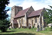
still meets at the ecumenical parish church of St. Mary.
), Tinkers Bridge and Passmore, although it is not connected by road to any of them: all development is accessed via Newport Road, the former B488. The housing is predominantly private, mainly built in the 1970s. The only employment in the area is a working farm. In terms of population, it is the smallest wholly residential area recognised by the council in Milton Keynes.
Milton Keynes
Milton Keynes , sometimes abbreviated MK, is a large town in Buckinghamshire, in the south east of England, about north-west of London. It is the administrative centre of the Borough of Milton Keynes...
, ceremonial county
Ceremonial counties of England
The ceremonial counties are areas of England to which are appointed a Lord Lieutenant, and are defined by the government as counties and areas for the purposes of the Lieutenancies Act 1997 with reference to the metropolitan and non-metropolitan counties of England and Lieutenancies Act 1997...
of Buckinghamshire
Buckinghamshire
Buckinghamshire is a ceremonial and non-metropolitan home county in South East England. The county town is Aylesbury, the largest town in the ceremonial county is Milton Keynes and largest town in the non-metropolitan county is High Wycombe....
, England
England
England is a country that is part of the United Kingdom. It shares land borders with Scotland to the north and Wales to the west; the Irish Sea is to the north west, the Celtic Sea to the south west, with the North Sea to the east and the English Channel to the south separating it from continental...
. It takes its name from the original ecclesiastic parish of Woughton and its original village, Woughton on the Green.
The pronunciation of Woughton is ˈwʌftən .
Civil Parish
The civil parish of Woughton is enclosed by the A5 to the west, the River OuzelRiver Ouzel
The River Ouzel , also known as the River Lovat, is a river in England, and a tributary of the River Great Ouse. It rises in the Chiltern Hills and flows 20 miles north to join the Ouse at Newport Pagnell....
to the east, Chafron Way (H7) to the north and Groveway (H9) to the south. The Parish Council offices are in Farthing Grove, Netherfield. It consists of these districts:
Beanhill
The building of the Beanhill area of Milton Keynes started in 1973/1974 during a strike by brick makers. Hence phase one was constructed by timber frame with corrugated cladding. The later phase two bungalows are brick-built. From the original build, with the exception of the roads of Capron and Simnel (which are two story houses), the rest of the residential buildings were all bungalows. After construction every new home came with a tree voucher, compliments of The Milton Keynes Development Corporation, known then as the MKDC. More recently there have been additional roads / buildings slotted in. For example where Bracken House now stands there was originally allotments. In 1989 phase three introduced 35 shared ownership homes in the Wheatcroft Close area.In keeping with the 1970s Milton Keynes culture there were various arts projects within the Beanhill community. Notably the underpass painted in the Wizard of Oz theme, which was between Beanhill and Coffee Hall, at the back of Lammas. Also the Toadstools, created by Sue McFarland, on the field behind Simnel, they are still there. In Beanhill's very early days there was also a street theatre based there called The Beanhill Flat Earth Society. They performed around MK.
Currently Beanhill benefits from local shops, a meeting place, a medical centre, and a first school and a nursery, both called Moorlands, although on different sites.
Bleak Hall
This district, next to the West Coast Main LineWest Coast Main Line
The West Coast Main Line is the busiest mixed-traffic railway route in Britain, being the country's most important rail backbone in terms of population served. Fast, long-distance inter-city passenger services are provided between London, the West Midlands, the North West, North Wales and the...
, is dedicated to light industry, construction industry supply and 'big shed' retail. The name Bleak Hall derives from a nearby farm. The streets of Bleak Hall are named after characters and places in the book Bleak House
Bleak House
Bleak House is the ninth novel by Charles Dickens, published in twenty monthly installments between March 1852 and September 1853. It is held to be one of Dickens's finest novels, containing one of the most vast, complex and engaging arrays of minor characters and sub-plots in his entire canon...
by Charles Dickens.
Coffee Hall
Coffee Hall consists of council and privately owned housing and a local shopping centre, including a church, local shop, fish and chip shop and the much loved locally Chinese restaurant & takeaway - Beijing Peter. Coffee Hall also houses a first school and the Coffee Hall Out Of School Project (CHOOSP) which offers child minding services for professional parents during office hours. Coffee Hall is located between Leadenhall, Eaglestone, Netherfield & Beanhill.The roads on Coffee Hall are all named after old London coffee houses hence the name Coffee Hall.
Eaglestone
Eaglestone is home to Milton Keynes General HospitalMilton Keynes General Hospital
Milton Keynes General Hospital is a district general hospital serving Milton Keynes, its borough in Buckinghamshire and the surrounding area of south Northamptonshire and north-west Bedfordshire. It is located in the neighbourhood of Eaglestone, and opened in 1984. It is managed by Milton Keynes...
, a large combined school (Falconhurst) and a retirement village. The layout of Eaglestone's residential area is unique in that it is mostly off road, with houses surrounding picturesque parks with child's playing equipment, outdoor furniture (often used for street parties) and vast quantities of greenery. Eaglestone has a ring road which leads into various parking garage areas with the housing streets themselves away from roads. Eaglestone has a local shopping centre, featuring a hairdressing salon, basketball & squash courts, activity centre, a public house (The Eagle), a veterinarians clinic, an off licence shop and also a much famed and locally popular fish and chip restaurant (The Brothers Fish Bar).
Leadenhall
Leadenhall contains the Woughton Campus of Milton Keynes CollegeMilton Keynes College
Milton Keynes College is a general further education and training college, serving the Borough of Milton Keynes. It also serves the surrounding areas...
, Milton Keynes Academy
Milton Keynes Academy
Milton Keynes Academy is a secondary school in Leadenhall, Milton Keynes, United Kingdom. It is an Academy built in 2009 on the site of the former Sir Frank Markham Comprehensive School. It is situated adjacent to Milton Keynes College. It specialises in business and enterprise and is designed to...
, St Pauls School, Milton Keynes and Woughton Leisure Centre — including The Pitz performance space. (This general area of the district is usually called Woughton Campus).
Netherfield
Netherfield is a housing estate located opposite Milton Keynes General HospitalMilton Keynes General Hospital
Milton Keynes General Hospital is a district general hospital serving Milton Keynes, its borough in Buckinghamshire and the surrounding area of south Northamptonshire and north-west Bedfordshire. It is located in the neighbourhood of Eaglestone, and opened in 1984. It is managed by Milton Keynes...
, it also has a large shopping district featuring a co-op, public house, African food specialists, kebab house, Chinese takeaway, fish & chip shop and a doctors surgery (The Grove). The Parish Council offices are in Farthing Grove, Netherfield.
The estate was largely designed by Dixon, Jones, Gold and Cross around 1971, and is essentially modernist; it comprises several long parallel terraces, designed around the landform so that the roofline remains level: homes towards the top of the slopes are single storey; those at the bottom are three storey. The choice of prefabricated construction materials was partly a consequence of a shortage of bricks in the UK at the time. Milton Keynes Council has gradually been renovating the estate, adding a pitched roof when funds permit.
Peartree Bridge
Peartree Bridge is situated to the West of the Grand Union canalGrand Union Canal
The Grand Union Canal in England is part of the British canal system. Its main line connects London and Birmingham, stretching for 137 miles with 166 locks...
. There are two eateries in the area, Sam's Chinese and the Toby Inn restaurant, pub & hotel. Peartree Bridge has a small farm (InterAction) that provides workshops for local children including circus camp, pottery and community friendly underpass painting.
Redmoor
Redmoor is an industrial district. Notable organisations based there include Post Office Parcels.Tinkers Bridge
Tinkers Bridge is an estate of mainly social housing. It is part of a grid square that also includes Passmore and Woughton Park private housing.Woughton on the Green
Woughton on the Green is a traditional BuckinghamshireHistory of Buckinghamshire
Although the name Buckinghamshire is Anglo Saxon in origin meaning The district of Bucca's home the name has only been recorded since about the 12th century. The historic county itself has been in existence since it was a subdivision of the kingdom of Wessex in the 10th century...
village
Village
A village is a clustered human settlement or community, larger than a hamlet with the population ranging from a few hundred to a few thousand , Though often located in rural areas, the term urban village is also applied to certain urban neighbourhoods, such as the West Village in Manhattan, New...
that is now part of Milton Keynes
Milton Keynes
Milton Keynes , sometimes abbreviated MK, is a large town in Buckinghamshire, in the south east of England, about north-west of London. It is the administrative centre of the Borough of Milton Keynes...
in England
England
England is a country that is part of the United Kingdom. It shares land borders with Scotland to the north and Wales to the west; the Irish Sea is to the north west, the Celtic Sea to the south west, with the North Sea to the east and the English Channel to the south separating it from continental...
. It gives its name to the Civil parish
Civil parish
In England, a civil parish is a territorial designation and, where they are found, the lowest tier of local government below districts and counties...
of Woughton, of which it is now a part.
Village green
A village green is a common open area which is a part of a settlement. Traditionally, such an area was often common grass land at the centre of a small agricultural settlement, used for grazing and sometimes for community events...
.
In the Domesday Book
Domesday Book
Domesday Book , now held at The National Archives, Kew, Richmond upon Thames in South West London, is the record of the great survey of much of England and parts of Wales completed in 1086...
of 1086 Woughton on the Green was recorded as Ulchetone. This is an Anglo-Saxon
Old English language
Old English or Anglo-Saxon is an early form of the English language that was spoken and written by the Anglo-Saxons and their descendants in parts of what are now England and southeastern Scotland between at least the mid-5th century and the mid-12th century...
name, which means Eoca's Farm. The village had gained its more modern name by the mid twelfth century when the manor
Manorialism
Manorialism, an essential element of feudal society, was the organizing principle of rural economy that originated in the villa system of the Late Roman Empire, was widely practiced in medieval western and parts of central Europe, and was slowly replaced by the advent of a money-based market...
was recorded as belonging to the Verley family.
By the time of the coronation of Queen Victoria
Victoria of the United Kingdom
Victoria was the monarch of the United Kingdom of Great Britain and Ireland from 20 June 1837 until her death. From 1 May 1876, she used the additional title of Empress of India....
, Woughton on the Green was a large village, due largely to the nearby Grand Union Canal
Grand Union Canal
The Grand Union Canal in England is part of the British canal system. Its main line connects London and Birmingham, stretching for 137 miles with 166 locks...
and later to the (West Coast Main Line
West Coast Main Line
The West Coast Main Line is the busiest mixed-traffic railway route in Britain, being the country's most important rail backbone in terms of population served. Fast, long-distance inter-city passenger services are provided between London, the West Midlands, the North West, North Wales and the...
) railway that passed through to the nearby parish of Wolverton
Wolverton, Milton Keynes
Wolverton is a constituent town of Milton Keynes . It is at its northern edge, between Stony Stratford and Newport Pagnell...
.
Today the village is a suburb of Central Milton Keynes
Central Milton Keynes
Central Milton Keynes is the central business district of Milton Keynes, Buckinghamshire, England and a civil parish in its own right.The district is approximately 2.5 km long by 1 km wide and occupies some of the highest land in Milton Keynes...
, though the residents like to maintain their autonomy. It is noted for being the most exclusive residence in Milton Keynes. Jim Marshall, founder of Marshall Amplification, is a resident. The Parochial Church Council
Parochial Church Council
The parochial church council , is the executive body of a Church of England parish.-Powers and duties:Two Acts of Parliament define the powers and duties of PCCs...
still meets at the ecumenical parish church of St. Mary.
Woughton Park
Woughton Park lies between the Grand Union Canal and the River Ouzel, in the same grid square as Walton Hall (home to the Open UniversityOpen University
The Open University is a distance learning and research university founded by Royal Charter in the United Kingdom...
), Tinkers Bridge and Passmore, although it is not connected by road to any of them: all development is accessed via Newport Road, the former B488. The housing is predominantly private, mainly built in the 1970s. The only employment in the area is a working farm. In terms of population, it is the smallest wholly residential area recognised by the council in Milton Keynes.