
Woodsville, New Hampshire
Encyclopedia
Woodsville is a census-designated place
(CDP) in the town of Haverhill
in Grafton County
, New Hampshire
, U.S.
, along the Connecticut River
at the mouth of the Ammonoosuc River
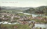
. The population was 1,126 at the 2010 census. Although North Haverhill is officially the county seat of Grafton County, the village of Woodsville has traditionally been considered the county seat, as the county courthouse was originally located there. The county buildings are now located halfway between Woodsville and the village of North Haverhill to the south.
, a village across the Connecticut River
narrows in Newbury
, and in 1829 purchased a sawmill
which had been operating on the Ammonoosuc River
since 1811. He manufactured pine
lumber
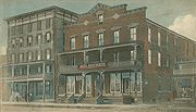
, and opened a store in his house. The Boston, Concord & Montreal Railroad opened at Woodsville in 1853 and built its division offices and a branch repair shop. It replaced the original 1805 bridge between the states with a two-level span, featuring a toll highway below and railroad tracks on the roof. The village boomed into an important railway town
and junction, endowed with fine examples of Victorian architecture
. It also became a center for legal affairs. In 1889, the Grafton County Court moved from Haverhill Corner to Woodsville, where it remained until moving halfway to North Haverhill in 1972.
According to the United States Census Bureau
, the CDP has a total area of 0.9 square miles (2.3 km²), of which 1.10% is water. Woodsville is drained by the Ammonoosuc River
, which reaches its confluence
with the Connecticut River
in the village.
Woodsville is crossed by U.S. Route 302
, and state routes 10
and 135
.
 As of the census
of 2000, there were 1,081 people, 457 households, and 283 families residing in the CDP. The population density
was 1,209.4 people per square mile (469.0/km²). There were 517 housing units at an average density of 578.4 per square mile (224.3/km²). The racial makeup of the CDP was 98.06% White, 0.83% African American, 0.46% Native American, 0.09% Asian, 0.09% Pacific Islander, and 0.46% from two or more races. Hispanic or Latino of any race were 0.46% of the population.
There were 457 households out of which 28.0% had children under the age of 18 living with them, 44.0% were married couples
living together, 13.3% had a female householder with no husband present, and 37.9% were non-families. 30.9% of all households were made up of individuals and 12.3% had someone living alone who was 65 years of age or older. The average household size was 2.36 and the average family size was 2.90.
 In the CDP the population was spread out with 24.1% under the age of 18, 9.0% from 18 to 24, 28.1% from 25 to 44, 22.3% from 45 to 64, and 16.6% who were 65 years of age or older. The median age was 38 years. For every 100 females there were 91.7 males. For every 100 females age 18 and over, there were 86.2 males.
The median income for a household in the CDP was $31,771, and the median income for a family was $37,857. Males had a median income of $27,180 versus $22,176 for females. The per capita income
for the CDP was $16,145. About 14.0% of families and 10.2% of the population were below the poverty line, including 17.3% of those under age 18 and 4.5% of those age 65 or over.
, by Stephen King, Woodsville is mentioned as the home of Glendon Pequod Bateman, a major character in the novel. He was an associate professor of sociology at the fictional Woodsville Community College when the Superflu hit, and claimed that Woodsville was famous for its college and "five gas stations".
Census-designated place
A census-designated place is a concentration of population identified by the United States Census Bureau for statistical purposes. CDPs are delineated for each decennial census as the statistical counterparts of incorporated places such as cities, towns and villages...
(CDP) in the town of Haverhill
Haverhill, New Hampshire
Haverhill is a town in Grafton County, New Hampshire, United States. The population was 4,697 at the 2010 census. Haverhill includes the villages of Woodsville, Pike, and North Haverhill, the historic town center at Haverhill Corner, and the district of Mountain Lakes...
in Grafton County
Grafton County, New Hampshire
Grafton County is a county located in the U.S. state of New Hampshire. As of the 2010 census, the population was 89,118. Its county seat is North Haverhill, which is a village within the town of Haverhill. Until 1972, the county courthouse and other offices were located in downtown Woodsville, a...
, New Hampshire
New Hampshire
New Hampshire is a state in the New England region of the northeastern United States of America. The state was named after the southern English county of Hampshire. It is bordered by Massachusetts to the south, Vermont to the west, Maine and the Atlantic Ocean to the east, and the Canadian...
, U.S.
United States
The United States of America is a federal constitutional republic comprising fifty states and a federal district...
, along the Connecticut River
Connecticut River
The Connecticut River is the largest and longest river in New England, and also an American Heritage River. It flows roughly south, starting from the Fourth Connecticut Lake in New Hampshire. After flowing through the remaining Connecticut Lakes and Lake Francis, it defines the border between the...
at the mouth of the Ammonoosuc River
Ammonoosuc River
The Ammonoosuc River is a river, 55 mi long, in northwestern New Hampshire in the United States. It is a tributary of the Connecticut River, which flows to Long Island Sound. "Ammonoosuc" is Abnaki for "small, narrow fishing place"....
. The population was 1,126 at the 2010 census. Although North Haverhill is officially the county seat of Grafton County, the village of Woodsville has traditionally been considered the county seat, as the county courthouse was originally located there. The county buildings are now located halfway between Woodsville and the village of North Haverhill to the south.
History
Woodsville was named for John L. Woods, a figure in its early development. He arrived from Wells River, VermontWells River, Vermont
Wells River is a village in the town of Newbury in Orange County, Vermont, United States. The population was 325 at the 2000 census. The village center is located at the junction of U.S...
, a village across the Connecticut River
Connecticut River
The Connecticut River is the largest and longest river in New England, and also an American Heritage River. It flows roughly south, starting from the Fourth Connecticut Lake in New Hampshire. After flowing through the remaining Connecticut Lakes and Lake Francis, it defines the border between the...
narrows in Newbury
Newbury (town), Vermont
Newbury is a town in Orange County, Vermont, United States. The population was 1,955 at the 2000 census. Newbury includes the villages of Newbury, Center Newbury, West Newbury, South Newbury, Boltonville, Peach Four Corners, and Wells River.-History:...
, and in 1829 purchased a sawmill
Sawmill
A sawmill is a facility where logs are cut into boards.-Sawmill process:A sawmill's basic operation is much like those of hundreds of years ago; a log enters on one end and dimensional lumber exits on the other end....
which had been operating on the Ammonoosuc River
Ammonoosuc River
The Ammonoosuc River is a river, 55 mi long, in northwestern New Hampshire in the United States. It is a tributary of the Connecticut River, which flows to Long Island Sound. "Ammonoosuc" is Abnaki for "small, narrow fishing place"....
since 1811. He manufactured pine
Pine
Pines are trees in the genus Pinus ,in the family Pinaceae. They make up the monotypic subfamily Pinoideae. There are about 115 species of pine, although different authorities accept between 105 and 125 species.-Etymology:...
lumber
Lumber
Lumber or timber is wood in any of its stages from felling through readiness for use as structural material for construction, or wood pulp for paper production....
, and opened a store in his house. The Boston, Concord & Montreal Railroad opened at Woodsville in 1853 and built its division offices and a branch repair shop. It replaced the original 1805 bridge between the states with a two-level span, featuring a toll highway below and railroad tracks on the roof. The village boomed into an important railway town
Railway town
A railway town is a settlement that originated or was greatly developed because of a railway station or junction at its site.In Victorian Britain, the spread of railways greatly affected the fate of many small towns...
and junction, endowed with fine examples of Victorian architecture
Victorian architecture
The term Victorian architecture refers collectively to several architectural styles employed predominantly during the middle and late 19th century. The period that it indicates may slightly overlap the actual reign, 20 June 1837 – 22 January 1901, of Queen Victoria. This represents the British and...
. It also became a center for legal affairs. In 1889, the Grafton County Court moved from Haverhill Corner to Woodsville, where it remained until moving halfway to North Haverhill in 1972.
Geography
Woodsville is located at 44°9′08"N 72°2′13"W (44.1522, -72.0369).According to the United States Census Bureau
United States Census Bureau
The United States Census Bureau is the government agency that is responsible for the United States Census. It also gathers other national demographic and economic data...
, the CDP has a total area of 0.9 square miles (2.3 km²), of which 1.10% is water. Woodsville is drained by the Ammonoosuc River
Ammonoosuc River
The Ammonoosuc River is a river, 55 mi long, in northwestern New Hampshire in the United States. It is a tributary of the Connecticut River, which flows to Long Island Sound. "Ammonoosuc" is Abnaki for "small, narrow fishing place"....
, which reaches its confluence
Confluence
Confluence, in geography, describes the meeting of two or more bodies of water.Confluence may also refer to:* Confluence , a property of term rewriting systems...
with the Connecticut River
Connecticut River
The Connecticut River is the largest and longest river in New England, and also an American Heritage River. It flows roughly south, starting from the Fourth Connecticut Lake in New Hampshire. After flowing through the remaining Connecticut Lakes and Lake Francis, it defines the border between the...
in the village.
Woodsville is crossed by U.S. Route 302
U.S. Route 302 in New Hampshire
U.S. Route 302 crosses the northern part of New Hampshire, entering the state by bridging the Connecticut River from Wells River, Vermont, following the Ammonoosuc River into the White Mountains, passing through Crawford Notch and following the Saco River out of the mountains to Fryeburg, Maine...
, and state routes 10
New Hampshire Route 10
New Hampshire Route 10 is a north–south state highway in the U.S. state of New Hampshire. Its southern terminus is at the Massachusetts state line in the town of Winchester. In Massachusetts the highway becomes Massachusetts Route 10. Total length of the highway is .-Route description:NH 10...
and 135
New Hampshire Route 135
New Hampshire Route 135 is a long north–south state highway in New Hampshire. The highway runs north along the Connecticut River from Woodsville to Lancaster....
.
Demographics
Census
A census is the procedure of systematically acquiring and recording information about the members of a given population. It is a regularly occurring and official count of a particular population. The term is used mostly in connection with national population and housing censuses; other common...
of 2000, there were 1,081 people, 457 households, and 283 families residing in the CDP. The population density
Population density
Population density is a measurement of population per unit area or unit volume. It is frequently applied to living organisms, and particularly to humans...
was 1,209.4 people per square mile (469.0/km²). There were 517 housing units at an average density of 578.4 per square mile (224.3/km²). The racial makeup of the CDP was 98.06% White, 0.83% African American, 0.46% Native American, 0.09% Asian, 0.09% Pacific Islander, and 0.46% from two or more races. Hispanic or Latino of any race were 0.46% of the population.
There were 457 households out of which 28.0% had children under the age of 18 living with them, 44.0% were married couples
Marriage
Marriage is a social union or legal contract between people that creates kinship. It is an institution in which interpersonal relationships, usually intimate and sexual, are acknowledged in a variety of ways, depending on the culture or subculture in which it is found...
living together, 13.3% had a female householder with no husband present, and 37.9% were non-families. 30.9% of all households were made up of individuals and 12.3% had someone living alone who was 65 years of age or older. The average household size was 2.36 and the average family size was 2.90.
The median income for a household in the CDP was $31,771, and the median income for a family was $37,857. Males had a median income of $27,180 versus $22,176 for females. The per capita income
Per capita income
Per capita income or income per person is a measure of mean income within an economic aggregate, such as a country or city. It is calculated by taking a measure of all sources of income in the aggregate and dividing it by the total population...
for the CDP was $16,145. About 14.0% of families and 10.2% of the population were below the poverty line, including 17.3% of those under age 18 and 4.5% of those age 65 or over.
Notable residents
- Chad ParontoChad ParontoChad Michael Paronto is an American Baseball player. Paronto attended the University of Massachusetts before being drafted by the Baltimore Orioles in the eighth round of the amateur draft. Paronto's best pitches include a 90-94 mph fastball and a heavy sinker which he uses mainly with men...
, baseball player - Bob Smith, baseball player
- Mark SteynMark SteynMark Steyn is a Canadian-born writer, conservative-leaning political commentator, and cultural critic. He has written five books, including America Alone: The End of the World As We Know It, a New York Times bestseller...
, columnist and author
In popular culture
In The StandThe Stand
The Stand is a post-apocalyptic horror/fantasy novel by American author Stephen King. It demonstrates the scenario in his earlier short story, Night Surf...
, by Stephen King, Woodsville is mentioned as the home of Glendon Pequod Bateman, a major character in the novel. He was an associate professor of sociology at the fictional Woodsville Community College when the Superflu hit, and claimed that Woodsville was famous for its college and "five gas stations".