
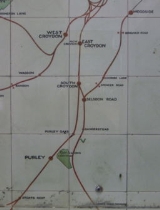
Woodside and South Croydon Railway
Encyclopedia

London Borough of Croydon
The London Borough of Croydon is a London borough in South London, England and is part of Outer London. It covers an area of and is the largest London borough by population. It is the southernmost borough of London. At its centre is the historic town of Croydon from which the borough takes its name...
in London
London
London is the capital city of :England and the :United Kingdom, the largest metropolitan area in the United Kingdom, and the largest urban zone in the European Union by most measures. Located on the River Thames, London has been a major settlement for two millennia, its history going back to its...
, England
England
England is a country that is part of the United Kingdom. It shares land borders with Scotland to the north and Wales to the west; the Irish Sea is to the north west, the Celtic Sea to the south west, with the North Sea to the east and the English Channel to the south separating it from continental...
. Its site is now largely occupied by Tramlink
Tramlink
Tramlink is a tramway system in south London in the United Kingdom which began operation in May 2000...
.
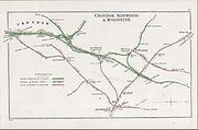
Route
| OS Grid Ref British national grid reference system The Ordnance Survey National Grid reference system is a system of geographic grid references used in Great Britain, different from using latitude and longitude.... and map link TQ … |
|||
| Woodside station | Junction with the Addiscombe branch of the South Eastern Railway South Eastern Railway (UK) The South Eastern Railway was a railway company in south-eastern England from 1836 until 1922. The company was formed to construct a route from London to Dover. Branch lines were later opened to Tunbridge Wells, Hastings, Canterbury and other places in Kent... . Now Woodside tram stop Woodside tram stop Woodside tram stop is a light rail stop situated between Woodside Green and Ashburton Park in the London Borough of Croydon in the southern suburbs of London... . Tramlink Tramlink Tramlink is a tramway system in south London in the United Kingdom which began operation in May 2000... follows most of the route of the W&SC from here to Coombe Road. |
||
| Blackhorse Lane tram stop Blackhorse Lane tram stop Blackhorse Lane tram stop is a light rail stop in the London Borough of Croydon in the southern suburbs of London.The tram stop is served by Tramlink routes:* 1 * 2... |
|||
| Bingham Road halt Bingham Road railway halt Bingham Road railway station was a railway station in Addiscombe, Croydon at . It was opened on 1 July 1906 by the South Eastern and Chatham Railway. Two wooden platforms without buildings were constructed, on the north side of Bingham Road, on the embankment of the existing Woodside and South... |
The railway was on an embankment here and crossed over Lower Addiscombe Road and Bingham Road on bridges. The embankment has been removed and Tramlink crosses both these roads at grade At-grade intersection An at-grade intersection is a junction at which two or more transport axes cross at the same level .-Traffic management:With areas of high or fast traffic, an at-grade intersection normally requires a traffic control device such as a stop sign, traffic light or railway signal to manage conflicting... . The halt was just south of Bingham Road; Addiscombe tram stop Addiscombe tram stop Addiscombe tram stop is a light rail stop in the London Borough of Croydon in the southern suburbs of London.The tram stop is served by Tramlink routes:* 1 * 2... is between Lower Addiscombe Road and Bingham Road. (Addiscombe railway station was about 500 m to the west - East India Way has been built on its site.) |
||
| About 200 m east of Sandilands tram stop Sandilands tram stop Sandilands tram stop is a light rail stop in the London Borough of Croydon in the southern suburbs of London. It serves the residential area along Addiscombe Road to the east of the centre of the town of Croydon.... the Tramlink route from central Croydon divides and both branches follow the route of the W&SC. The northern line takes a sharp turn under Addiscombe Road to join the route of the railway to Woodside (and from there to Elmers End Elmers End station Elmers End station is a railway station and tram terminus in Elmers End, South London, England. It is in the London Borough of Bromley, and Travelcard Zone 4 south of London Charing Cross.... and Beckenham Junction Beckenham Junction station Beckenham Junction is a railway station and a tram terminus in Beckenham, south east London. It is in the London Borough of Bromley and Travelcard Zone 4, 8.6 miles from London Victoria.... ). The other line turns southward into the Park Hill tunnels towards Coombe Road (and from there to New Addington New Addington New Addington is an area on the edge of South London in the London Borough of Croydon. It is a large local authority estate surrounded by open countryside, woodland and golf courses. The Prime Meridian crosses the eastern edge of New Addington... ). |
|||
| Park Hill tunnels under Radcliffe Road and Deepdene Avenue | |||
| Coombe Road station, originally Coombe Lane | Just south of here Tramlink takes a sharp turn east to diverge from the W&SC route, and reaches Lloyd Park tram stop Lloyd Park tram stop Lloyd Park tram stop is in the London Borough of Croydon in the southern suburbs of London on the edge of Lloyd Park, beside Coombe Road and opposite Croham Park Avenue and Castlemaine Avenue.... after about 200 m. (Coombe Lane tram stop Coombe Lane tram stop Coombe Lane tram stop is a light rail stop in the London Borough of Croydon in the southern suburbs of London. It is located next to Addington Hills serving Royal Russell School and the Ballards residential estate close to Upper Shirley, Addington and Coombe.... is about 2 km further east.) |
||
| Spencer Road Halt | Hidden in an alleyway between Spencer Road and Birdhurst Rise. | ||
| The railway crossed Croham Road on a bridge, still extant. | |||
| Selsdon station, originally Selsdon Road | Junction with the Oxted Line Oxted Line The Oxted Line is a railway line in southern England. It was originally operated jointly by the London, Brighton and South Coast Railway and the South Eastern Railway. It is now part of the Southern franchise.... , the former Croydon, Oxted and East Grinstead Railway. The W&SC platforms are still intact, as is the spur that leads to the old goods yard and oil storage depot. |
||
History
The line opened jointly by the London, Brighton and South Coast RailwayLondon, Brighton and South Coast Railway
The London, Brighton and South Coast Railway was a railway company in the United Kingdom from 1846 to 1922. Its territory formed a rough triangle, with London at its apex, practically the whole coastline of Sussex as its base, and a large part of Surrey...
(LBSCR) and the South Eastern Railway
South Eastern Railway (UK)
The South Eastern Railway was a railway company in south-eastern England from 1836 until 1922. The company was formed to construct a route from London to Dover. Branch lines were later opened to Tunbridge Wells, Hastings, Canterbury and other places in Kent...
(SER). Although the intention had been to begin train services in 1882, completion was delayed until August 1885 for various reasons, including bad weather disrupting construction. Success was limited even at the beginning, and following a closure proposal as early as 1895 railmotors were introduced in 1905 in an attempt to improve efficiency and counteract competition from trams and buses. (See a picture of one of the railmotors here.) At this time the two halts were opened: although Spencer Road met with little success, Bingham Road attracted more custom with its main-road location and from passengers interchanging with trams and buses; it was rebuilt as a full station (see below).
The first official closure came in 1917, although services had been suspended for the most part since 1915, to save money and resources for the war effort
World War I
World War I , which was predominantly called the World War or the Great War from its occurrence until 1939, and the First World War or World War I thereafter, was a major war centred in Europe that began on 28 July 1914 and lasted until 11 November 1918...
. It was still possible for diverted trains and excursions or other special services to use the line.
Major changes came in 1935:
- The line was electrified on the third railThird railA third rail is a method of providing electric power to a railway train, through a semi-continuous rigid conductor placed alongside or between the rails of a railway track. It is used typically in a mass transit or rapid transit system, which has alignments in its own corridors, fully or almost...
system; - Bingham Road halt was rebuilt as a full station;
- Coombe Lane was rebuilt and renamed Coombe Road;
- Selsdon Road was renamed Selsdon, although the village of that nameSelsdonSelsdon is an area located in the southern suburbs of the London Borough of Croydon. The suburb was developed during the inter-war period during the 1920s and 1930s, and is remarkable for its many Art Deco houses...
was approximately 2 miles away; - The remains of Spencer Road halt were cleared away;
- A new half-hourly service, seven days a week, augmented during weekday peak hours, was introduced - this compares with the previous best service level of 16 trains daily from 1906 until 1915;
- Services ran direct to London at all times, between Sanderstead and either London Charing CrossCharing Cross railway stationCharing Cross railway station, also known as London Charing Cross, is a central London railway terminus in the City of Westminster, England. It is one of 18 stations managed by Network Rail, and trains serving it are operated by Southeastern...
or London Cannon StreetCannon Street stationCannon Street station, also known as London Cannon Street, is a central London railway terminus and London Underground complex in the City of London, England. It is built on the site of the medieval Steelyard, the trading base in England of the Hanseatic League...
.
The electric service commenced on 30 September 1935, but the decline towards final closure began soon afterwards:
- Services were reduced during World War IIWorld War IIWorld War II, or the Second World War , was a global conflict lasting from 1939 to 1945, involving most of the world's nations—including all of the great powers—eventually forming two opposing military alliances: the Allies and the Axis...
, with the withdrawal of Saturday afternoon and Sunday trains; - In the 1950s through trains to London ran at peak hours only, with a Sanderstead–Elmers End shuttle at other times, connecting with Hayes–London trains);
- A closure threat came in the Beeching ReportBeeching AxeThe Beeching Axe or the Beeching Cuts are informal names for the British Government's attempt in the 1960s to reduce the cost of running British Railways, the nationalised railway system in the United Kingdom. The name is that of the main author of The Reshaping of British Railways, Dr Richard...
of 1963, but local pressure (through, for example, the newly-formed Croydon Transport Users' Association) brought about a reprieve; - Saturday trains were withdrawn in 1967;
- In 1976 through trains to London were withdrawn, leaving a Sanderstead–Elmers End peak hours shuttle service;
- Closure took place on 13 May 1983.
1980 timetable: an illustrative example
This table shows the up service three years before closure:| Sanderstead | Selsdon | Coombe Road | Bingham Road | Woodside | Elmers End |
|---|---|---|---|---|---|
| Morning Peak | |||||
| 06:45 | 06:47 | 06:49 | 06:51 | 06:53 | 06:56 |
| 07:15 | 07:17 | 07:19 | 07:21 | 07:23 | 07:26 |
| 07:32 | 07:37 | 07:39 | 07:41 | 07:43 | 07:46 |
| 07:53 | 07:57 | 07:59 | 08:01 | 08:03 | 08:06 |
| 08:14 | 08:17 | 08:19 | 08:21 | 08:23 | 08:26 |
| 08:32 | 08:37 | 08:39 | 08:41 | 08:43 | 08:46 |
| — | 08:57 | 08:59 | 09:01 | 09:03 | 09:06 |
| 09:15 | 09:17 | 09:19 | 09:21 | 09:23 | 09:26 |
| 09:48 | 09:50 | 09:52 | 09:54 | 09:57 | 10:00 |
| Evening Peak | |||||
| 16:15 | 16:17 | 16:19 | 16:21 | 16:23 | 16:26 |
| 16:31 | 16:37 | 16:39 | 16:41 | 16:43 | 16:46 |
| 16:52 | 16:57 | 16:59 | 17:01 | 17:03 | 17:06 |
| 17:12 | 17:17 | 17:19 | 17:21 | 17:23 | 17:26 |
| — | 17:37 | 17:39 | 17:41 | 17:43 | 17:46 |
| 17:55 | 17:57 | 17:59 | 18:01 | 18:03 | 18:06 |
| 18:15 | 18:17 | 18:19 | 18:21 | 18:23 | 18:26 |
| 18:37 | 18:39 | 18:41 | 18:43 | 18:45 | 18:48 |
| 18:50 | 18:52 | — | — | — | 18:59 |
| 19:15 | 19:17 | 19:19 | 19:22 | 19:24 | 19:27 |
Two trains per day started from and terminated at Selsdon rather than Sanderstead because of the lack of train paths on the section shared with the Oxted Line.
See also
- Addiscombe Line
- Coombe, CroydonCoombe, CroydonCoombe is a place in the London Borough of Croydon, not far from central Croydon.Coombe is located between the green spaces of Shirley Hills, Lloyd Park, Ballards and Coombe Wood. It is unusual in this part of South London as it has barely been urbanised and has retained its collection of large...
- South CroydonSouth CroydonSouth Croydon is a locality in Greater London, the area surrounding the valley south of central Croydon about 1 km in radius, centred on the Red Deer public house on the Brighton Road. It is part of the South Croydon post town and in the London Borough of Croydon...
- Sanderstead stationSanderstead railway stationSanderstead railway station is in the London Borough of Croydon, a mile from Sanderstead village. It is in Travelcard Zone 6.The station, operated by Southern, is served by Oxted Line trains from East Grinstead and Uckfield to East Croydon and London Bridge and London Victoria.On the London-bound...
- List of closed railway stations in Britain
External links
- A page about the railway from Transport of Delight
- Bingham Road halt and other details from Subterranea Britannica
- A singularly unedifying photograph of the site of Spencer Road Halt
- A pictorial look at the railway from Disused Railways