
Sandilands tram stop
Encyclopedia
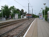
Sandilands tram stop is a light rail
stop in the London Borough of Croydon
in the southern suburbs of London
. It serves the residential area along Addiscombe Road to the east of the centre of the town of Croydon
.
The tram stop is served by all three Tramlink
routes:
Bus stops adjacent to the tram stop provide interchange with the following bus services (as of January 2008):
Immediately to the east of the tram stop, the line descends in cutting to a junction with the trackbed of the former Woodside and South Croydon Railway
. Tramlink route 3 diverges to the south along this trackbed, whilst routes 1 and 2 diverge to the north along the same trackbed. To the west of the stop, the line runs alongside Addiscombe Road on a reserved track
as far as the junction with Chepstow Road. From Chepstow Road the line runs within Addiscombe Road, sharing road space with buses and local traffic.
The area of Sandilands tram stop was one of the few places where property demolition was needed during the construction of Tramlink, in order to make way for both the stop and the cutting link to the former railway line.
Light rail
Light rail or light rail transit is a form of urban rail public transportation that generally has a lower capacity and lower speed than heavy rail and metro systems, but higher capacity and higher speed than traditional street-running tram systems...
stop in the London Borough of Croydon
London Borough of Croydon
The London Borough of Croydon is a London borough in South London, England and is part of Outer London. It covers an area of and is the largest London borough by population. It is the southernmost borough of London. At its centre is the historic town of Croydon from which the borough takes its name...
in the southern suburbs of London
London
London is the capital city of :England and the :United Kingdom, the largest metropolitan area in the United Kingdom, and the largest urban zone in the European Union by most measures. Located on the River Thames, London has been a major settlement for two millennia, its history going back to its...
. It serves the residential area along Addiscombe Road to the east of the centre of the town of Croydon
Croydon
Croydon is a town in South London, England, located within the London Borough of Croydon to which it gives its name. It is situated south of Charing Cross...
.
The tram stop is served by all three Tramlink
Tramlink
Tramlink is a tramway system in south London in the United Kingdom which began operation in May 2000...
routes:
- 1Tramlink route 1Tramlink route 1 is one of three tram routes operated as part of the Tramlink network in south London. The route is operated by London Tramlink, part of Transport for London .- History :...
(Central Croydon to Elmers EndElmers EndElmers End is a place in London Borough of Bromley, England. It has a large green space which is the centre of a gyratory. Very close to the combined railway station and Tramlink terminus bearing its name is the old sewage farm. The remains of this industrial site can still be seen...
) - 2Tramlink route 2Tramlink route 2 is one of three tram routes operated as part of the Tramlink network in south London. The route is operated by London Tramlink, part of Transport for London under the Tramlink brand.- History :...
(Central Croydon to BeckenhamBeckenhamBeckenham is a town in the London Borough of Bromley, England. It is located 8.4 miles south east of Charing Cross and 1.75 miles west of Bromley town...
) - 3Tramlink route 3Tramlink route 3 is one of three tram routes operated as part of the Tramlink network in south London. The route is owned and operated by Transport for London ....
(WimbledonWimbledon, LondonWimbledon is a district in the south west area of London, England, located south of Wandsworth, and east of Kingston upon Thames. It is situated within Greater London. It is home to the Wimbledon Tennis Championships and New Wimbledon Theatre, and contains Wimbledon Common, one of the largest areas...
to New AddingtonNew AddingtonNew Addington is an area on the edge of South London in the London Borough of Croydon. It is a large local authority estate surrounded by open countryside, woodland and golf courses. The Prime Meridian crosses the eastern edge of New Addington...
via central Croydon).
Bus stops adjacent to the tram stop provide interchange with the following bus services (as of January 2008):
- 119 – BromleyBromleyBromley is a large suburban town in south east London, England and the administrative headquarters of the London Borough of Bromley. It was historically a market town, and prior to 1963 was in the county of Kent and formed the administrative centre of the Municipal Borough of Bromley...
– Central Croydon – Croydon (Purley Way); - 194London Buses route 194London Buses route 194 is a Transport for London contracted bus route in London, United Kingdom. The service is currently contracted to Arriva London.-History:...
– SydenhamSydenhamSydenham is an area and electoral ward in the London Borough of Lewisham; although some streets towards Crystal Palace Park, Forest Hill and Penge are outside the ward and in the London Borough of Bromley, and some streets off Sydenham Hill are in the London Borough of Southwark. Sydenham was in...
– Central Croydon; - 198 – Shrublands – Central Croydon – Thornton HeathThornton HeathThornton Heath is a district of south London, England, in the London Borough of Croydon. It is situated south-southeast of Charing Cross.-Geography:...
; - 466London Buses route 466London Buses route 466 is a Transport for London contracted bus route in London, United Kingdom. The service is currently contracted to Arriva London.-History:Route 466 is similar to the original route 166...
– Addington VillageAddington, LondonAddington is a district of south London, England, located in the London Borough of Croydon. It is situated south south-east of Charing Cross.-History:...
– Central Croydon – PurleyPurley, LondonPurley is a place in the London Borough of Croydon, England. It is a suburban development situated 11.7 miles south of Charing Cross.The name derives from "pirlea", which means 'Peartree lea'. Purley has a population of about 72,000....
– Caterham on the HillCaterham on the HillCaterham-on-the-Hill is a civil parish in Tandridge District Council in Surrey. It has a population of 11,555 and is the oldest part of Caterham. The parish council clerk is Helen Broughton....
;
Immediately to the east of the tram stop, the line descends in cutting to a junction with the trackbed of the former Woodside and South Croydon Railway
Woodside and South Croydon Railway
The Woodside and South Croydon Joint Railway was a short, relatively short-lived and unsuccessful railway in the London Borough of Croydon in London, England. Its site is now largely occupied by Tramlink.- Route :- History :...
. Tramlink route 3 diverges to the south along this trackbed, whilst routes 1 and 2 diverge to the north along the same trackbed. To the west of the stop, the line runs alongside Addiscombe Road on a reserved track
Reserved track
In tram transport terminology reserved track is track on ground exclusively for trams. Unlike track on streets and roads, reserved track does not need to take into account the transit of other wheeled vehicles, pedestrians, bicyclists or horses...
as far as the junction with Chepstow Road. From Chepstow Road the line runs within Addiscombe Road, sharing road space with buses and local traffic.
The area of Sandilands tram stop was one of the few places where property demolition was needed during the construction of Tramlink, in order to make way for both the stop and the cutting link to the former railway line.