
Windy Gyle
Encyclopedia
Windy Gyle is a hill
in the Cheviot Hills
, right on the border
between England
and Scotland
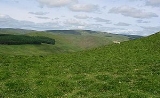
. It lies on the border ridge, and like the other hills in the area is rounded and grass
-covered. Although maps show the border passing right through the summit, the summit cairn
lies a few metres north of the fence that marks the border. The cairn at the summit of this hill is titled Russel's Cairn, the cairn has a small depression suitable for shielding 15 people from the wind.
The Pennine Way
crosses the summit, thus providing one possible route of ascent. Windy Gyle may also be climbed from the Coquet
valley to the south (England), or from Cocklawfoot to the north (Scotland). There are a number or routes from both sides, and circular walks are possible.
There are good views from the summit north towards the Scottish Borders
, Eildon Hills and Edinburgh
.
Hill
A hill is a landform that extends above the surrounding terrain. Hills often have a distinct summit, although in areas with scarp/dip topography a hill may refer to a particular section of flat terrain without a massive summit A hill is a landform that extends above the surrounding terrain. Hills...
in the Cheviot Hills
Cheviot Hills
The Cheviot Hills is a range of rolling hills straddling the England–Scotland border between Northumberland and the Scottish Borders.There is a broad split between the northern and the southern Cheviots...
, right on the border
Anglo-Scottish border
The Anglo-Scottish border is the official border and mark of entry between Scotland and England. It runs for 154 km between the River Tweed on the east coast and the Solway Firth in the west. It is Scotland's only land border...
between England
England
England is a country that is part of the United Kingdom. It shares land borders with Scotland to the north and Wales to the west; the Irish Sea is to the north west, the Celtic Sea to the south west, with the North Sea to the east and the English Channel to the south separating it from continental...
and Scotland
Scotland
Scotland is a country that is part of the United Kingdom. Occupying the northern third of the island of Great Britain, it shares a border with England to the south and is bounded by the North Sea to the east, the Atlantic Ocean to the north and west, and the North Channel and Irish Sea to the...
. It lies on the border ridge, and like the other hills in the area is rounded and grass
Grass
Grasses, or more technically graminoids, are monocotyledonous, usually herbaceous plants with narrow leaves growing from the base. They include the "true grasses", of the Poaceae family, as well as the sedges and the rushes . The true grasses include cereals, bamboo and the grasses of lawns ...
-covered. Although maps show the border passing right through the summit, the summit cairn
Cairn
Cairn is a term used mainly in the English-speaking world for a man-made pile of stones. It comes from the or . Cairns are found all over the world in uplands, on moorland, on mountaintops, near waterways and on sea cliffs, and also in barren desert and tundra areas...
lies a few metres north of the fence that marks the border. The cairn at the summit of this hill is titled Russel's Cairn, the cairn has a small depression suitable for shielding 15 people from the wind.
The Pennine Way
Pennine Way
The Pennine Way is a National Trail in England. The trail runs from Edale, in the northern Derbyshire Peak District, north through the Yorkshire Dales and the Northumberland National Park and ends at Kirk Yetholm, just inside the Scottish border. The path runs along the Pennine hills, sometimes...
crosses the summit, thus providing one possible route of ascent. Windy Gyle may also be climbed from the Coquet
River Coquet
The River Coquet runs through the county of Northumberland, England, discharging into the North Sea on the east coast of England at Amble. Warkworth Castle is built in a loop of the Coquet....
valley to the south (England), or from Cocklawfoot to the north (Scotland). There are a number or routes from both sides, and circular walks are possible.
There are good views from the summit north towards the Scottish Borders
Scottish Borders
The Scottish Borders is one of 32 local government council areas of Scotland. It is bordered by Dumfries and Galloway in the west, South Lanarkshire and West Lothian in the north west, City of Edinburgh, East Lothian, Midlothian to the north; and the non-metropolitan counties of Northumberland...
, Eildon Hills and Edinburgh
Edinburgh
Edinburgh is the capital city of Scotland, the second largest city in Scotland, and the eighth most populous in the United Kingdom. The City of Edinburgh Council governs one of Scotland's 32 local government council areas. The council area includes urban Edinburgh and a rural area...
.