
Wild River State Park
Encyclopedia
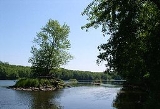
Wild River State Park is a 6803 acres (27.5 km²) state park
of Minnesota
, USA, curving along 18 miles (29 km) of the St. Croix River
. This long, narrow park is shaped somewhat like a sideways 'S', with development largely concentrated in the lower third. The remote upper sections flank the mouth of a tributary called the Sunrise River
. The park is named after the St. Croix's designation as a National Wild and Scenic River
.
formed by volcanic activity 1.1 billion years ago. This is overlain by a thick layer of glacial debris. During the Wisconsin glaciation
16,000 years ago a small glacial lobe branched northeast off the Des Moines Lobe, blocking drainage from farther north. Water backed up into Glacial Lake Grantburg. The soil in the park is quite sandy from the sediments that accumulated in this now vanished lake. At the end of this ice age 10,000 years ago, meltwater flowing out of Glacial Lake Duluth
carved the St. Croix River Valley. Today the river is one hundred times smaller than its glacial maximum. The ancient bank of the river is a bluff running through the park, well back from the current riverbed.
. These habitats were disrupted by logging and farming. Today the park is a mix of second-growth forest and meadow. As the river tends to overflow its banks in spring, inundation-tolerant species like silver maple and basswood dominate the floodplain. Wetlands are scattered throughout the park. Berries are prevalent along the trails, as are wild roses. Each month throughout spring and summer brings different wildflowers in bloom. Some common spring flowers include wild columbine
(Aquilegia canadensis), wild Geranium (Geranium maculatum), and Carolina puccoon (Lithospermum caroliniense). During the summer, visitors can see Black-eyed Susan
(Rudbeckia hirta), butterfly milkweed (Asclepias tuberosa), and rough blazing star (Liatris aspera). Fall brings its own mix of wildflowers, including many asters and goldenrods. There is also a variety of native grasses, including big bluestem
(Andropogon gerardii), little bluestem
(Schizachyrium scoparium), and indian grass (Sorghastrum nutans).
Restoration
is currently taking place through the park's Prairie Care Project, to rehabilitate oak savanna and prairie areas. These efforts involve controlled burn
ing to reduce built-up thatch and clearing plantations of farmer-introduced pines. The Prairie Care Project allows and encourages volunteers to participate in seed collection in the fall and seed sowing in the spring. Volunteers can also help with seed processing in the winter months. Species Stewards are special volunteers who "adopt" a species in the park. They come to the park at least once every two weeks to locate their plant, check its progress towards bloom and seed production, and collect seed to be sown in new locations.
Wild River State Park is also trying to reduce or eliminate the population of non-native, invasive buckthorn
within park boundaries. Volunteers are again encouraged to join in, either by simply stopping to pull buckthorn for a few hours or by getting more involved by joining the Buckthorn-Free Zone initiative. The Buckthorn-Free Zone initiative allows volunteers to claim a portion, or "zone", of the park as their own with the responsibility of eventually making it Buckthorn-Free.
The park's narrowness reduces its quality as wildlife habitat somewhat. Nevertheless, it serves as north-south continuous corrider along the St. Croix River, which is used as a migration route for many birds. Prevalent mammals include beaver
, raccoon
, fox
, coyote
, otter
, squirrel
, mink
, and white-tailed deer
. Black bear
sightings are on the rise. Ducks, herons, and bitterns frequent the wetlands. Wild River State Park's bird list documents 200 species that can be viewed at different times throughout the year. One birding highlight is in May, an excellent time to view the warbler migration.
The towns of Sunrise
, Amador
, and Almelund
were founded in the 1850s. Land was also sold in the town of Nashua, which may have been a confidence trick
. The town never existed except on paper and was in fact sited in a marsh.
In 1855 the federal government began building the Point Douglas to Superior Military Road
. Although intended as a highway for troop movement, this route from Hastings, Minnesota
to Superior, Wisconsin
was one of the first roads in the territory and attracted a flood of civilian and commercial traffic. When Minnesota achieved statehood in 1858, responsibility for the road devolved to the state, which did not have the funds to finish the project. Although very rough and in places incomplete, the road was still the best route north until railroads were built in 1870. Traces of the military road can still be seen here and in Banning State Park
.
Following an 1837 treaty with the Ojibwa
, territory including the park was opened up to logging
. The primary target was the massive Eastern White Pine
, which could grow up to 200 feet (61 m) tall. Timber felled here and farther north was floated down the St. Croix River to sawmills
in Stillwater
. The lumber industry was bedeviled by massive log jams in 1867, 1877, 1883, and 1886. The 1883 jam, at Angle Rock in what is now Interstate Park
, was the world's biggest log jam and took 57 days to break, during which the sawmill in Marine on St. Croix
went out of business. To alleviate the problem, the Nevers Dam was built here in 1889-90 to control the flow of logs downstream. The dam created a 10 miles (16.1 km) lake in which logs could be safely massed. Gates were opened at two-week intervals to send a steady supply of lumber to Stillwater. The biweekly batch of logs could be up to a mile and a half long. A 600 feet (182.9 m) long earthen dike, still visible, was built back from the dam to prevent the reservoir from overflowing. The park's usable timber was gone by 1902, and the following year Northern States Power
bought the dam to control the river's flow while they built a hydroelectric dam
at St. Croix Falls
. Log drives from farther upriver continued occasionally until 1912. In the 1940s public sentiment turned against the dam because of its impacts on recreation and conservation. The sluicegates began to be left open each summer. Severe floodwaters in 1954 left Nevers Dam structurally unsafe, and NSP removed it the following year.
In addition to Nevers Dam, NSP had acquired much of the land on either side of the river. With the St. Croix Falls Dam completed in 1907, NSP had little further need for this property 11 miles (17.7 km) upstream. They discussed contributing the land to the state as early as the 1930s. However, it was the creation of the Saint Croix National Scenic Riverway
in 1968 that finally prompted action by both parties. The main objection to the trade had always been that Chisago County would lose a sizeable amount of property tax income. Bills died twice in the Minnesota Legislature
until the state park was finally authorized in 1973. As a compromise the state agreed to pay the county a declining percentage of the lost tax revenue for 10 years. NSP donated 4497 acres (18.2 km²) and the value was matched by federal funds to buy land from other owners. The Nature Conservancy
also assisted in acquiring property. Development began in 1976 and the park opened two years later. Originally called St. Croix Wild River State Park, the name was shortened to avoid confusion with St. Croix State Park
.
State park
State parks are parks or other protected areas managed at the federated state level within those nations which use "state" as a political subdivision. State parks are typically established by a state to preserve a location on account of its natural beauty, historic interest, or recreational...
of Minnesota
Minnesota
Minnesota is a U.S. state located in the Midwestern United States. The twelfth largest state of the U.S., it is the twenty-first most populous, with 5.3 million residents. Minnesota was carved out of the eastern half of the Minnesota Territory and admitted to the Union as the thirty-second state...
, USA, curving along 18 miles (29 km) of the St. Croix River
St. Croix River (Wisconsin-Minnesota)
The St. Croix River is a tributary of the Mississippi River, approximately long, in the U.S. states of Wisconsin and Minnesota. The lower of the river form the border between Wisconsin and Minnesota. The river is a National Scenic Riverway under the protection of the National Park Service. A...
. This long, narrow park is shaped somewhat like a sideways 'S', with development largely concentrated in the lower third. The remote upper sections flank the mouth of a tributary called the Sunrise River
Sunrise River
The Sunrise River is a short tributary of the St. Croix River in east-central Minnesota in the United States. It is formed at the town of Stacy in Chisago County by the confluence of its West Branch, which rises in southwestern Isanti County and briefly enters Anoka County; and its South Branch,...
. The park is named after the St. Croix's designation as a National Wild and Scenic River
National Wild and Scenic River
National Wild and Scenic River is a designation for certain protected areas in the United States.The National Wild and Scenic Rivers Act was an outgrowth of the recommendations of a Presidential commission, the Outdoor Recreation Resources Review Commission...
.
Geology
The bedrock of the park is basaltBasalt
Basalt is a common extrusive volcanic rock. It is usually grey to black and fine-grained due to rapid cooling of lava at the surface of a planet. It may be porphyritic containing larger crystals in a fine matrix, or vesicular, or frothy scoria. Unweathered basalt is black or grey...
formed by volcanic activity 1.1 billion years ago. This is overlain by a thick layer of glacial debris. During the Wisconsin glaciation
Wisconsin glaciation
The last glacial period was the most recent glacial period within the current ice age occurring during the last years of the Pleistocene, from approximately 110,000 to 10,000 years ago....
16,000 years ago a small glacial lobe branched northeast off the Des Moines Lobe, blocking drainage from farther north. Water backed up into Glacial Lake Grantburg. The soil in the park is quite sandy from the sediments that accumulated in this now vanished lake. At the end of this ice age 10,000 years ago, meltwater flowing out of Glacial Lake Duluth
Glacial Lake Duluth
Glacial Lake Duluth was a proglacial lake that formed in the Lake Superior drainage basin as the Laurentide ice sheet retreated. The oldest existing shorelines were formed after retreat from the Greatlakean advance, sometime around 11,000 years B.P. Lake Duluth formed at the western end of the Lake...
carved the St. Croix River Valley. Today the river is one hundred times smaller than its glacial maximum. The ancient bank of the river is a bluff running through the park, well back from the current riverbed.
Flora and fauna
This area was originally a transition zone between pine forest, hardwood forest, and oak savannaOak savanna
An oak savanna is a type of savanna, or lightly forested grassland, where oaks are the dominant tree species. These savannas were maintained historically through wildfires set by lightning, grazing, low precipitation, poor soil, and/or fires set by Native Americans...
. These habitats were disrupted by logging and farming. Today the park is a mix of second-growth forest and meadow. As the river tends to overflow its banks in spring, inundation-tolerant species like silver maple and basswood dominate the floodplain. Wetlands are scattered throughout the park. Berries are prevalent along the trails, as are wild roses. Each month throughout spring and summer brings different wildflowers in bloom. Some common spring flowers include wild columbine
Wild Columbine
Aquilegia canadensis is a herbaceous perennial native to woodland and rocky slopes in eastern North America, prized for its red and yellow flowers. It readily hybridizes with other species in the genus.-Description:Height is...
(Aquilegia canadensis), wild Geranium (Geranium maculatum), and Carolina puccoon (Lithospermum caroliniense). During the summer, visitors can see Black-eyed Susan
Black-eyed Susan
Black-eyed Susan may refer to one of several things:Flowers* Rudbeckia hirta, a member of the sunflower tribe of the large family Asteraceae* A number of other members of the genus Rudbeckia* Hibiscus trionum in the family Malvaceae...
(Rudbeckia hirta), butterfly milkweed (Asclepias tuberosa), and rough blazing star (Liatris aspera). Fall brings its own mix of wildflowers, including many asters and goldenrods. There is also a variety of native grasses, including big bluestem
Big Bluestem
Andropogon gerardii, known also as Big bluestem, Turkey foot, Prairie tallgrass, or simply Tallgrass, is a tall grass native to much of the Great Plains and Prairie regions of central North America- Description :...
(Andropogon gerardii), little bluestem
Little bluestem
Schizachyrium scoparium, commonly known as little bluestem or beard grass, is a North American prairie grass. Little bluestem is a perennial bunchgrass and is prominent in tallgrass prairie, along with big bluestem , indiangrass and switchgrass...
(Schizachyrium scoparium), and indian grass (Sorghastrum nutans).
Restoration
Restoration ecology
-Definition:Restoration ecology is the scientific study and practice of renewing and restoring degraded, damaged, or destroyed ecosystems and habitats in the environment by active human intervention and action, within a short time frame...
is currently taking place through the park's Prairie Care Project, to rehabilitate oak savanna and prairie areas. These efforts involve controlled burn
Controlled burn
Controlled or prescribed burning, also known as hazard reduction burning or Swailing is a technique sometimes used in forest management, farming, prairie restoration or greenhouse gas abatement. Fire is a natural part of both forest and grassland ecology and controlled fire can be a tool for...
ing to reduce built-up thatch and clearing plantations of farmer-introduced pines. The Prairie Care Project allows and encourages volunteers to participate in seed collection in the fall and seed sowing in the spring. Volunteers can also help with seed processing in the winter months. Species Stewards are special volunteers who "adopt" a species in the park. They come to the park at least once every two weeks to locate their plant, check its progress towards bloom and seed production, and collect seed to be sown in new locations.
Wild River State Park is also trying to reduce or eliminate the population of non-native, invasive buckthorn
Buckthorn
The Buckthorns are a genus of about 100 species of shrubs or small trees from 1-10 m tall , in the buckthorn family Rhamnaceae...
within park boundaries. Volunteers are again encouraged to join in, either by simply stopping to pull buckthorn for a few hours or by getting more involved by joining the Buckthorn-Free Zone initiative. The Buckthorn-Free Zone initiative allows volunteers to claim a portion, or "zone", of the park as their own with the responsibility of eventually making it Buckthorn-Free.
The park's narrowness reduces its quality as wildlife habitat somewhat. Nevertheless, it serves as north-south continuous corrider along the St. Croix River, which is used as a migration route for many birds. Prevalent mammals include beaver
Beaver
The beaver is a primarily nocturnal, large, semi-aquatic rodent. Castor includes two extant species, North American Beaver and Eurasian Beaver . Beavers are known for building dams, canals, and lodges . They are the second-largest rodent in the world...
, raccoon
Raccoon
Procyon is a genus of nocturnal mammals, comprising three species commonly known as raccoons, in the family Procyonidae. The most familiar species, the common raccoon , is often known simply as "the" raccoon, as the two other raccoon species in the genus are native only to the tropics and are...
, fox
Fox
Fox is a common name for many species of omnivorous mammals belonging to the Canidae family. Foxes are small to medium-sized canids , characterized by possessing a long narrow snout, and a bushy tail .Members of about 37 species are referred to as foxes, of which only 12 species actually belong to...
, coyote
Coyote
The coyote , also known as the American jackal or the prairie wolf, is a species of canine found throughout North and Central America, ranging from Panama in the south, north through Mexico, the United States and Canada...
, otter
Otter
The Otters are twelve species of semi-aquatic mammals which feed on fish and shellfish, and also other invertebrates, amphibians, birds and small mammals....
, squirrel
Squirrel
Squirrels belong to a large family of small or medium-sized rodents called the Sciuridae. The family includes tree squirrels, ground squirrels, chipmunks, marmots , flying squirrels, and prairie dogs. Squirrels are indigenous to the Americas, Eurasia, and Africa and have been introduced to Australia...
, mink
Mink
There are two living species referred to as "mink": the European Mink and the American Mink. The extinct Sea Mink is related to the American Mink, but was much larger. All three species are dark-colored, semi-aquatic, carnivorous mammals of the family Mustelidae, which also includes the weasels and...
, and white-tailed deer
White-tailed Deer
The white-tailed deer , also known as the Virginia deer or simply as the whitetail, is a medium-sized deer native to the United States , Canada, Mexico, Central America, and South America as far south as Peru...
. Black bear
American black bear
The American black bear is a medium-sized bear native to North America. It is the continent's smallest and most common bear species. Black bears are omnivores, with their diets varying greatly depending on season and location. They typically live in largely forested areas, but do leave forests in...
sightings are on the rise. Ducks, herons, and bitterns frequent the wetlands. Wild River State Park's bird list documents 200 species that can be viewed at different times throughout the year. One birding highlight is in May, an excellent time to view the warbler migration.
History
Archaeological remains have been found in the park dating back 5000 years, but the majority of artifacts date from 1200–500 years ago. A village site from this time has been identified near the mouth of the Sunrise River. A fur trading post was built on top of the ancient village site in 1847. Together with a post established nearby in 1850, these were the last trading posts in the St. Croix Valley, and only operated for a few years.The towns of Sunrise
Sunrise Township, Minnesota
Sunrise Township is a township in Chisago County, Minnesota, United States. The population was 1,594 at the 2000 census.-Geography:According to the United States Census Bureau, the township has a total area of 45.9 square miles , of which, 45.3 square miles of it is land and...
, Amador
Amador Township, Minnesota
Amador Township is a township in Chisago County, Minnesota, United States. The population was 744 at the 2000 census. The community of Almelund lies in the township.-Geography:...
, and Almelund
Almelund, Minnesota
Almelund is a small unincorporated community, in Amador Township, Chisago County, Minnesota, United States. It is located about 55 miles north-northeast of Minneapolis at the intersection of Minnesota State Highway 95 and Chisago County Road 12 ....
were founded in the 1850s. Land was also sold in the town of Nashua, which may have been a confidence trick
Confidence trick
A confidence trick is an attempt to defraud a person or group by gaining their confidence. A confidence artist is an individual working alone or in concert with others who exploits characteristics of the human psyche such as dishonesty and honesty, vanity, compassion, credulity, irresponsibility,...
. The town never existed except on paper and was in fact sited in a marsh.
In 1855 the federal government began building the Point Douglas to Superior Military Road
Point Douglas to Superior Military Road
Point Douglas to Superior Military Road, also known as Point Douglas to St. Louis River Military Road and as Douglas Highway, was a road the ran between Point Douglas, located at the outlet of the Lower St. Croix Lake near Hastings, Minnesota, first to the falls of the St. Louis River near Thomson,...
. Although intended as a highway for troop movement, this route from Hastings, Minnesota
Hastings, Minnesota
Hastings is a city in Dakota counties in the U.S. state of Minnesota, near the confluence of the Mississippi and St. Croix Rivers. The population was 22,172 at the 2010 census. It is the county seat of Dakota County. The bulk of Hastings is in Dakota County; only a small part of the city extends...
to Superior, Wisconsin
Superior, Wisconsin
Superior is a city in and the county seat of Douglas County, Wisconsin, United States. The population was 26,960 at the 2010 census. Located at the junction of U.S. Highways 2 and 53, it is north of and adjacent to both the Village of Superior and the Town of Superior.Superior is at the western...
was one of the first roads in the territory and attracted a flood of civilian and commercial traffic. When Minnesota achieved statehood in 1858, responsibility for the road devolved to the state, which did not have the funds to finish the project. Although very rough and in places incomplete, the road was still the best route north until railroads were built in 1870. Traces of the military road can still be seen here and in Banning State Park
Banning State Park
Banning State Park is a Minnesota state park stretched along of the Kettle River near Sandstone, Minnesota in Pine County. The centerpiece of the park is of churning rapids, some up to Class IV. The daring kayakers and canoeists who shoot Blueberry Slide, Mother's Delight, Dragon's Tooth,...
.
Following an 1837 treaty with the Ojibwa
Ojibwa
The Ojibwe or Chippewa are among the largest groups of Native Americans–First Nations north of Mexico. They are divided between Canada and the United States. In Canada, they are the third-largest population among First Nations, surpassed only by Cree and Inuit...
, territory including the park was opened up to logging
Logging
Logging is the cutting, skidding, on-site processing, and loading of trees or logs onto trucks.In forestry, the term logging is sometimes used in a narrow sense concerning the logistics of moving wood from the stump to somewhere outside the forest, usually a sawmill or a lumber yard...
. The primary target was the massive Eastern White Pine
Eastern White Pine
Pinus strobus, commonly known as the eastern white pine, is a large pine native to eastern North America, occurring from Newfoundland west to Minnesota and southeastern Manitoba, and south along the Appalachian Mountains to the northern edge of Georgia.It is occasionally known as simply white pine,...
, which could grow up to 200 feet (61 m) tall. Timber felled here and farther north was floated down the St. Croix River to sawmills
Sawmills
Sawmills may refer to:* A sawmill, a facility where logs are cut to length* Sawmills Studio, a famous UK music recording studio* Sawmills, North Carolina...
in Stillwater
Stillwater, Minnesota
As of the census of 2000, there were 15,143 people, 5,797 households, and 4,115 families residing in the city. The population density was 2,340.0 people per square mile . There were 5,926 housing units at an average density of 915.7 per square mile...
. The lumber industry was bedeviled by massive log jams in 1867, 1877, 1883, and 1886. The 1883 jam, at Angle Rock in what is now Interstate Park
Interstate Park
Interstate Park comprises two adjacent state parks on the Minnesota-Wisconsin border, both named Interstate State Park. They straddle the Dalles of the St. Croix River, a deep basalt gorge with glacial potholes and other rock formations. The Wisconsin park is and the Minnesota park is . The...
, was the world's biggest log jam and took 57 days to break, during which the sawmill in Marine on St. Croix
Marine on St. Croix, Minnesota
Marine on St. Croix is a city in Washington County, Minnesota, United States. The population was 689 at the 2010 census.-Geography:According to the United States Census Bureau, the city has a total area of , of which, of it is land and of it is water. Minnesota State Highway 95 serves as a main...
went out of business. To alleviate the problem, the Nevers Dam was built here in 1889-90 to control the flow of logs downstream. The dam created a 10 miles (16.1 km) lake in which logs could be safely massed. Gates were opened at two-week intervals to send a steady supply of lumber to Stillwater. The biweekly batch of logs could be up to a mile and a half long. A 600 feet (182.9 m) long earthen dike, still visible, was built back from the dam to prevent the reservoir from overflowing. The park's usable timber was gone by 1902, and the following year Northern States Power
Xcel Energy
Xcel Energy, Inc. is a public utility company based in Minneapolis, Minnesota, serving customers in Colorado, Michigan, Minnesota, New Mexico, North Dakota, South Dakota, Texas, and Wisconsin. Primary services are electricity and natural gas...
bought the dam to control the river's flow while they built a hydroelectric dam
Hydroelectricity
Hydroelectricity is the term referring to electricity generated by hydropower; the production of electrical power through the use of the gravitational force of falling or flowing water. It is the most widely used form of renewable energy...
at St. Croix Falls
St. Croix Falls, Wisconsin
St. Croix Falls is a city in Polk County, Wisconsin, United States. The population was 2,033 at the 2000 census. The city is located within the Town of St. Croix Falls....
. Log drives from farther upriver continued occasionally until 1912. In the 1940s public sentiment turned against the dam because of its impacts on recreation and conservation. The sluicegates began to be left open each summer. Severe floodwaters in 1954 left Nevers Dam structurally unsafe, and NSP removed it the following year.
In addition to Nevers Dam, NSP had acquired much of the land on either side of the river. With the St. Croix Falls Dam completed in 1907, NSP had little further need for this property 11 miles (17.7 km) upstream. They discussed contributing the land to the state as early as the 1930s. However, it was the creation of the Saint Croix National Scenic Riverway
Saint Croix National Scenic Riverway
The Saint Croix National Scenic Riverway is a federally protected system of riverways located in eastern Minnesota and northwestern Wisconsin. It protects of river, including the St. Croix River , and the Namekagon River , as well as adjacent land along the rivers. The St...
in 1968 that finally prompted action by both parties. The main objection to the trade had always been that Chisago County would lose a sizeable amount of property tax income. Bills died twice in the Minnesota Legislature
Minnesota Legislature
The Minnesota Legislature is the legislative branch of government in the U.S. state of Minnesota. It is a bicameral legislature located at the Minnesota Capitol in Saint Paul and it consists of two houses: the lower Minnesota House of Representatives and the Minnesota Senate...
until the state park was finally authorized in 1973. As a compromise the state agreed to pay the county a declining percentage of the lost tax revenue for 10 years. NSP donated 4497 acres (18.2 km²) and the value was matched by federal funds to buy land from other owners. The Nature Conservancy
The Nature Conservancy
The Nature Conservancy is a US charitable environmental organization that works to preserve the plants, animals, and natural communities that represent the diversity of life on Earth by protecting the lands and waters they need to survive....
also assisted in acquiring property. Development began in 1976 and the park opened two years later. Originally called St. Croix Wild River State Park, the name was shortened to avoid confusion with St. Croix State Park
Saint Croix State Park
St. Croix State Park is a state park in Pine County, Minnesota, USA. The park follows the shore of the St. Croix River for and contains the last of the Kettle River. At it is the largest Minnesota state park. It was developed as a Recreational Demonstration Area in the 1930s...
.
Recreation
- Boating:
- A concessionaire based inside the park rents canoes hourly and daily, and provides shuttle service back from take-out points.
- Boat ramps in the main part of park and at the Sunrise access. JetskisJet skiJet Ski is the brand name of a personal watercraft manufactured by Kawasaki Heavy Industries. The name is sometimes mistakenly used by those unfamiliar with the personal watercraft industry to refer to any type of personal watercraft; however, the name is a valid trademark registered with the...
are prohibited.
- Camping:
- Campground with 96 sites (17 with electrical hookups)
- Group camp (5 sites each accommodating 30 people)
- 20 rustic sites within the horse camp with picket lines available
- Guest house (8 capacity)
- 6 camping cabins
- 8 backpacking sites scattered mostly at the very southern end of the park
- 8 canoe-camp sites spaced along the shore
- Events: Naturalist programs are held at the visitor center year round and the park rangers facilitate educational programs for schools and other groups. Evening events are conducted at the amphitheater adjacent to the campground.
- Fishing: Walleye, northern pike, and smallmouth bass can be caught in the St. Croix River.
- Trails: 35 miles (56.3 km) of hiking/cross-country skiing trails and 20 miles (32.2 km) of horse trails. The Aspen Knob Loop and Goose Creek Loop are primarily winter trails that receive minimal summer maintenance.
- Universal Trail (hiking/skiing/biking/accessible): A paved path from the trail center to the campground. The Old Logging Trail section follows the ancient river bluff (3 mi).
- River Trail (hiking/skiing): Crosses the floodplain from the visitor center to the Nevers Dam site (1.5 mi).
- River Terrace Loop (hiking/skiing): Descends the ancient bluff from the picnic area to the Nevers Dam site (1.5 mi).
- Mitigwaki Loop (hiking/skiing): Circles through oak woods near the visitor center (1 mi).
- Deer Creek Loop (hiking/skiing/horseback): Circles through the floodplain and riverbank south of the visitor center (3 mi).
- Amik's Pond Trail (hiking): An interpretive loop from the visitor center passing 2 beaver ponds. Amik means "beaver" in the Ojibwe languageOjibwe languageOjibwe , also called Anishinaabemowin, is an indigenous language of the Algonquian language family. Ojibwe is characterized by a series of dialects that have local names and frequently local writing systems...
(1 mi). - Windfall Trail (hiking): An interpretive loop from the visitor center through second-growth forest (1 mi).
- Amador Prairie Loops (hiking/skiing/horseback): Circle through restoration prairie and oak islands from the trail center (1 or 2 mi (3.2 km) option).
- Pioneer Loop (hiking/skiing/horseback): Circles through oak woods, savanna, and grassland (2 mi).
- Aspen Knob Loop (skiing/hiking): Circles through the hilly oak woods and white pine stands south of the park office (2 mi).
- White Pine Ridge Loop (hiking/skiing): Ascends a hill between the Aspen Knob and Pioneer loops for a view of the river valley (0.5 mi).
- Sunrise Loop (horseback/hiking/skiing): Circles east through bottomland forest from the Sunrise River access (5 mi).
- Sunrise Trail (horseback/hiking/skiing): Connects the Sunrise area to the main part of the park (10 mi).
- Goose Creek Loop (skiing/hiking/horseback): Circles northwest through bottomland forest from the Sunrise River access. Prone to flooding in spring (3 mi).
- Tubing: A business in the town of Sunrise offers tube trips down the Sunrise River with shuttle pickup.
- There is no official swimming area.
- Geocaching opportunities include the Minnesota State Park Geocaching ChallengeMinnesota State Park Geocaching ChallengeThe Minnesota State Park Geocaching Challenge took place from May 3rd, 2008 to January 1, 2009 in Minnesota State Parks. It took place to celebrate Minnesota's sesquicentennial or 150 year anniversary of statehood. A geocache is a container hidden anywhere across the globe that can be found using...
(Wild River State Park is a multi-cache with the starting coordinates N 45 31.583 W 092 44.645), Wild River State Park History Cache I (a puzzle cache which requires you to solve clues in order to determine the coordinates of the cache), and several other caches that are not sponsored by the park. More information can be found at geocaching.com.