
Wiconisco Canal
Encyclopedia
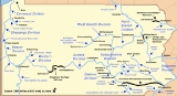
The Wiconisco Canal was a 19th century transportation waterway, about 12 miles (19 km) long, in Dauphin County
in the U.S. state of Pennsylvania
. Running along the east bank of the Susquehanna River
between Millersburg
and Duncan's Island at the mouth of the Juniata River
, the canal overcame about 42 feet (13 m) of vertical lift through the use of 7 locks
.
Started by the Commonwealth of Pennsylvania, the canal was completed in 1845 by a private firm and used to ship coal and other goods from northern Dauphin County to distant markets. Sold to a subsidiary of the Pennsylvania Railroad
, it continued operating until largely destroyed by a flood in 1889. The canal's biggest aqueduct, No. 3 near Halifax
, continues to serve as a highway bridge over Powell Creek
. It was added to the National Register of Historic Places
in 1988, as the Bridge in Reed Township
.
, the canal was designed by Samuel Krauss, engineer of the Eastern Division. Plans called for a dam at Clarks Ferry to provide water deep enough for canal boats to cross the Susquehanna River parallel to Clarks Ferry Bridge
and to enter or exit either canal.
After the Eastern Division canal was completed, John P. Rutherford, who had managed the final stages of the Eastern Division work near Harrisburg, was named construction superintendent for the Wiconisco project. In 1839, Simon Sallade, who replaced Rutherford as superintendent, divided the canal into 25 planning sections to keep track of cost estimates, construction bids, and details about the work. Structures such as locks were bid separately from work on the canal itself and included a feeder dam on Wiconisco Creek at Millersburg and three aqueduct
s. Aqueduct No. 3, which carried the canal over Powell Creek
and was the largest of the three aqueducts, was completed in 1840.
After 1841, the state discontinued work on the canal because of lack of funds. Because of currency depreciation related to the panics of 1837
and 1839, Pennsylvania defaulted on its debts, including money owed for canal work. In 1842, the state legislature incorporated a private firm, the Wiconisco Canal Company, to take over the canal. This company completed the canal and began using it in 1845. Under the management of Edward Gratz, the majority stockholder, the canal operated profitably through the 1850s and 1860s by shipping 60 to 170 ST (54.4 to 154.2 MT) of anthracite coal annually from mines in the nearby Lykens Valley. Other cargoes included timber, farm products, furniture, and building materials, which could reach markets such as Philadelphia via other branches of the Pennsylvania Canal and connecting canals. In 1871, the Wiconisco Canal's miscellaneous cargo included 677.5 short tons (614.6 MT) of railroad iron, "likely sowing the seeds of its own eventual demise".
Costly repairs and years of marginal returns led the canal company to sell its assets to the Pennsylvania Canal Company, a subsidiary of the Pennsylvania Railroad, in 1871. Because shipping coal by boat was cheaper than shipping it by rail, the canal continued to operate until a flood destroyed much of it in 1889. It was closed entirely in 1890 and never re-opened.
It is likely that Aqueduct No. 3, near Halifax, continued to carry land traffic over Powell Creek in the 1890s after the canal was destroyed. Because the passage between Peters Mountain to the east and the Susquehanna to the west is narrow, north- and southbound traffic had no other way to cross the creek. A state road map in 1928 showed Legislative Route No. 1 crossing the creek on the aqueduct. Renamed Pennsylvania Route 147
, the road continues to use the aqueduct as a bridge. The structure, referred to as "Bridge in Reed Township", was added to the National Register of Historic Places in 1988.
Dauphin County, Pennsylvania
Dauphin County is a county in the U.S. state of Pennsylvania and is one of the three counties comprising the Harrisburg–Carlisle Metropolitan Statistical Area. As of 2010 census, the population was 268,100. The county includes the city of Harrisburg, which has served as the state capital...
in the U.S. state of Pennsylvania
Pennsylvania
The Commonwealth of Pennsylvania is a U.S. state that is located in the Northeastern and Mid-Atlantic regions of the United States. The state borders Delaware and Maryland to the south, West Virginia to the southwest, Ohio to the west, New York and Ontario, Canada, to the north, and New Jersey to...
. Running along the east bank of the Susquehanna River
Susquehanna River
The Susquehanna River is a river located in the northeastern United States. At long, it is the longest river on the American east coast that drains into the Atlantic Ocean, and with its watershed it is the 16th largest river in the United States, and the longest river in the continental United...
between Millersburg
Millersburg, Pennsylvania
Millersburg is a borough in Dauphin County, Pennsylvania, United States. The population was 2,562 at the 2000 census. It is part of the Harrisburg–Carlisle Metropolitan Statistical Area.-Geography:...
and Duncan's Island at the mouth of the Juniata River
Juniata River
The Juniata River is a tributary of the Susquehanna River, approximately long, in central Pennsylvania in the United States. The river is considered scenic along much of its route, having a broad and shallow course passing through several mountain ridges and steeply-lined water gaps...
, the canal overcame about 42 feet (13 m) of vertical lift through the use of 7 locks
Lock (water transport)
A lock is a device for raising and lowering boats between stretches of water of different levels on river and canal waterways. The distinguishing feature of a lock is a fixed chamber in which the water level can be varied; whereas in a caisson lock, a boat lift, or on a canal inclined plane, it is...
.
Started by the Commonwealth of Pennsylvania, the canal was completed in 1845 by a private firm and used to ship coal and other goods from northern Dauphin County to distant markets. Sold to a subsidiary of the Pennsylvania Railroad
Pennsylvania Railroad
The Pennsylvania Railroad was an American Class I railroad, founded in 1846. Commonly referred to as the "Pennsy", the PRR was headquartered in Philadelphia, Pennsylvania....
, it continued operating until largely destroyed by a flood in 1889. The canal's biggest aqueduct, No. 3 near Halifax
Halifax, Pennsylvania
Halifax is a borough in Dauphin County, Pennsylvania, United States. Halifax was incorporated as a borough on May 29, 1785. The borough is situated at the confluence of Armstrong Creek and Susquehanna River. The population was 875 at the 2000 census...
, continues to serve as a highway bridge over Powell Creek
Powell Creek
Powell Creek is a tributary of the Susquehanna River in Dauphin County, Pennsylvania in the United States.Powell Creek is formed by the junction of its North and South forks southwest of Carsonville...
. It was added to the National Register of Historic Places
National Register of Historic Places
The National Register of Historic Places is the United States government's official list of districts, sites, buildings, structures, and objects deemed worthy of preservation...
in 1988, as the Bridge in Reed Township
Bridge in Reed Township
Bridge in Reed Township, originally known as Aqueduct No. 3 on the Wiconisco Canal, is a historic multi-span stone arch bridge spanning Powell's Creek at Reed Township, Dauphin County, Pennsylvania. It was built in 1860, as an aqueduct. The property measures 72 feet long by 50 feet wide...
.
History
The state began construction of the canal in 1837 or 1838. Originally built as an extension of the Eastern Division of the Pennsylvania CanalPennsylvania Canal
Pennsylvania Canal refers generally to a complex system of canals, dams, locks, tow paths, aqueducts, and other infrastructure including, in some cases, railroads in Pennsylvania...
, the canal was designed by Samuel Krauss, engineer of the Eastern Division. Plans called for a dam at Clarks Ferry to provide water deep enough for canal boats to cross the Susquehanna River parallel to Clarks Ferry Bridge
Clarks Ferry Bridge
The Clarks Ferry Bridge, carries U.S. Routes 22 and 322 across the Susquehanna River near Duncannon, Pennsylvania about 20 miles north of Harrisburg, Pennsylvania. It is a 4 lane expressway standard bridge. The bridge also provides safe passage for hikers, bikers, and pedestrians using the...
and to enter or exit either canal.
After the Eastern Division canal was completed, John P. Rutherford, who had managed the final stages of the Eastern Division work near Harrisburg, was named construction superintendent for the Wiconisco project. In 1839, Simon Sallade, who replaced Rutherford as superintendent, divided the canal into 25 planning sections to keep track of cost estimates, construction bids, and details about the work. Structures such as locks were bid separately from work on the canal itself and included a feeder dam on Wiconisco Creek at Millersburg and three aqueduct
Aqueduct
An aqueduct is a water supply or navigable channel constructed to convey water. In modern engineering, the term is used for any system of pipes, ditches, canals, tunnels, and other structures used for this purpose....
s. Aqueduct No. 3, which carried the canal over Powell Creek
Powell Creek
Powell Creek is a tributary of the Susquehanna River in Dauphin County, Pennsylvania in the United States.Powell Creek is formed by the junction of its North and South forks southwest of Carsonville...
and was the largest of the three aqueducts, was completed in 1840.
After 1841, the state discontinued work on the canal because of lack of funds. Because of currency depreciation related to the panics of 1837
Panic of 1837
The Panic of 1837 was a financial crisis or market correction in the United States built on a speculative fever. The end of the Second Bank of the United States had produced a period of runaway inflation, but on May 10, 1837 in New York City, every bank began to accept payment only in specie ,...
and 1839, Pennsylvania defaulted on its debts, including money owed for canal work. In 1842, the state legislature incorporated a private firm, the Wiconisco Canal Company, to take over the canal. This company completed the canal and began using it in 1845. Under the management of Edward Gratz, the majority stockholder, the canal operated profitably through the 1850s and 1860s by shipping 60 to 170 ST (54.4 to 154.2 MT) of anthracite coal annually from mines in the nearby Lykens Valley. Other cargoes included timber, farm products, furniture, and building materials, which could reach markets such as Philadelphia via other branches of the Pennsylvania Canal and connecting canals. In 1871, the Wiconisco Canal's miscellaneous cargo included 677.5 short tons (614.6 MT) of railroad iron, "likely sowing the seeds of its own eventual demise".
Costly repairs and years of marginal returns led the canal company to sell its assets to the Pennsylvania Canal Company, a subsidiary of the Pennsylvania Railroad, in 1871. Because shipping coal by boat was cheaper than shipping it by rail, the canal continued to operate until a flood destroyed much of it in 1889. It was closed entirely in 1890 and never re-opened.
It is likely that Aqueduct No. 3, near Halifax, continued to carry land traffic over Powell Creek in the 1890s after the canal was destroyed. Because the passage between Peters Mountain to the east and the Susquehanna to the west is narrow, north- and southbound traffic had no other way to cross the creek. A state road map in 1928 showed Legislative Route No. 1 crossing the creek on the aqueduct. Renamed Pennsylvania Route 147
Pennsylvania Route 147
Pennsylvania Route 147 is a north–south route that runs for along the east shore of the Susquehanna River in central Pennsylvania, United States. The northern terminus is at an interchange with Interstate 80 and Interstate 180 in Turbot Township. The southern terminus is at an interchange...
, the road continues to use the aqueduct as a bridge. The structure, referred to as "Bridge in Reed Township", was added to the National Register of Historic Places in 1988.
Points of interest
| Feature | Coordinates | Description |
|---|---|---|
| Millersburg Millersburg, Pennsylvania Millersburg is a borough in Dauphin County, Pennsylvania, United States. The population was 2,562 at the 2000 census. It is part of the Harrisburg–Carlisle Metropolitan Statistical Area.-Geography:... |
40°32′22"N 76°57′39"W | Town at the northern terminus |
| Duncan's Island | 40°25′02"N 77°00′33"W | Island at the southern terminus |