
.gif)
White Mountain (Wyoming)
Encyclopedia
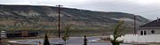
Green River, Wyoming
Green River is a city in and the county seat of Sweetwater County, Wyoming, United States, in the southwestern part of the state. The population was 11,808 at the 2000 census....
. The mountain is part of the Green River Formation
Green River Formation
The Green River Formation is an Eocene geologic formation that records the sedimentation in a group of intermountain lakes. The sediments are deposited in very fine layers, a dark layer during the growing season and a light-hue inorganic layer in winter. Each pair of layers is called a varve and...
, and contains communications towers that serve a number of purposes. Hundreds of carved figures also dot the sandstone cliffs at the White Mountain Petroglyph
Petroglyph
Petroglyphs are pictogram and logogram images created by removing part of a rock surface by incising, picking, carving, and abrading. Outside North America, scholars often use terms such as "carving", "engraving", or other descriptions of the technique to refer to such images...
site and range from 200 to 1000 years old. Pilot Butte, located on top of White Mountain, is accessible from roads on the mountain.
Geology
Like its neighbor, Wilkins PeakWilkins Peak
Wilkins Peak is a small mountain located in Sweetwater County, Wyoming, between the cities of Green River and Rock Springs. It is primarily used for radio and television station transmitters, but it also serves radio needs of the FAA, EMS, and local businesses such as Questar Gas. In 2003, a tower...
, White Mountain is a member of the Green River Formation, a formation of the intermontane
Intermontane
Intermontane is a physiographic adjective formed from the prefix "inter-" and the adjective "montane" Usage includes intermontane basin such as New Zealand's Mackenzie Basin and intermontane...
Lake Gosiute environment during the Eocene epoch
Eocene
The Eocene Epoch, lasting from about 56 to 34 million years ago , is a major division of the geologic timescale and the second epoch of the Paleogene Period in the Cenozoic Era. The Eocene spans the time from the end of the Palaeocene Epoch to the beginning of the Oligocene Epoch. The start of the...
. White Mountain is part of the Rock Springs Uplift. The Rock Springs Uplift itself formed in the Late Cretaceous period
Late Cretaceous
The Late Cretaceous is the younger of two epochs into which the Cretaceous period is divided in the geologic timescale. Rock strata from this epoch form the Upper Cretaceous series...
by large-scale folding. Some of the largest oil shale
Oil shale
Oil shale, an organic-rich fine-grained sedimentary rock, contains significant amounts of kerogen from which liquid hydrocarbons called shale oil can be produced...
and trona
Trona
Trona ; Na3•2H2O is an evaporite mineral. It is mined as the primary source of sodium carbonate in the United States, where it has replaced the Solvay process used in most of the rest of the world for sodium carbonate production.- Etymology :The word "trona" comes to English by way of either...
beds in the region are located west of the mountain. White Mountain contains sediment from a subcategory of the Green River Formation, known as the Wilkins Peak Formation.
The peak itself is 7623 feet (2,323 m) in elevation and is located 5.4 miles (9 km) from Rock Springs, Wyoming
Rock Springs, Wyoming
Rock Springs is a city in Sweetwater County, Wyoming, United States. The population was 18,708 at the 2000 census. Rock Springs is the principal city of the Rock Springs micropolitan statistical area, which has a population of 37,975....
and 8.85 miles (14 km) from Green River, Wyoming
Green River, Wyoming
Green River is a city in and the county seat of Sweetwater County, Wyoming, United States, in the southwestern part of the state. The population was 11,808 at the 2000 census....
.
Communication uses
White Mountain houses communication radio towers for a number of local and regional uses. A tower for the radio station K299AG broadcasts a religious radio format on 107.7 FM. Programming on the station comes from KCSP-FMKCSP-FM
KCSP-FM is a non-commercial radio station located in Casper, Wyoming. KCSP airs a programming from Pilgrim Radio, a religious radio network based out of Nevada. KCSP serves a number of translator stations throughout the state of Wyoming.-History:...
.
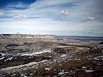
The local cable company, Sweetwater Television, owns the tallest tower, on the center of the mountain. This tower can be seen in the picture above. K28JU-D, the local PBS affiliate of KCWC-TV
KCWC-TV
Wyoming PBS is the Public Broadcasting Service member network in the state of Wyoming. It currently consists of flagship KCWC-TV, channel 4 in Riverton ; full-power satelites KWYP-TV, channel 8 in Laramie and KPTW, channel 6 in Casper; and 35 low-power translator stations across the state.The...
broadcasts from space on the tower as well, and as of August 2009, is the only television station broadcasting from White Mountain. Located next to that tower are transmitters used by the local BLM
Bureau of Land Management
The Bureau of Land Management is an agency within the United States Department of the Interior which administers America's public lands, totaling approximately , or one-eighth of the landmass of the country. The BLM also manages of subsurface mineral estate underlying federal, state and private...
office, as well as a tower for cellular telephones, owned by Union Wireless.
On the side of the mountain facing Green River, two more radio towers are present. One of the towers is used for airport communications from a nearby airport
Rock Springs - Sweetwater County Airport
Rock Springs-Sweetwater County Airport is a public airport located seven miles east of the central business district of Rock Springs, a city in Sweetwater County, Wyoming, USA. The airport covers and has two runways, 9/27 and 3/21...
. The other, owned by Verizon Wireless
Verizon Wireless
Cellco Partnership, doing business as Verizon Wireless, is one of the largest mobile network operators in the United States. The network has 107.7 million subscribers as of 2011, making it the largest wireless service provider in America....
is used for cellular telephone transmissions.
FM broadcasting
FM broadcasting is a broadcasting technology pioneered by Edwin Howard Armstrong which uses frequency modulation to provide high-fidelity sound over broadcast radio. The term "FM band" describes the "frequency band in which FM is used for broadcasting"...
stations and one TV station applying for construction permit
Construction permit
A construction permit or building permit is a permit required in most jurisdictions for new construction, or adding on to pre-existing structures, and in some cases for major renovations. Generally, the new construction must be inspected during construction and after completion to ensure compliance...
s on the mountain.
Pilot Butte
Pilot Butte is located directly on top of White Mountain, and was named by early travelers in the region as a signal that they were close to the Green RiverGreen River (Utah)
The Green River, located in the western United States, is the chief tributary of the Colorado River. The watershed of the river, known as the Green River Basin, covers parts of Wyoming, Utah, and Colorado. The Green River is long, beginning in the Wind River Mountains of Wyoming and flowing...
. Pilot Butte is also a part of the Wild Horse
Feral horse
A feral horse is a free-roaming horse of domesticated ancestry. As such, a feral horse is not a wild animal in the sense of an animal without domesticated ancestors. However, some populations of feral horses are managed as wildlife, and these horses often are popularly called "wild" horses...
tour, and several herds of wild horses have been spotted in the area. The butte is the second highest point in the immediate region, the first being Aspen Mountain
Aspen Mountain (Wyoming)
Aspen Mountain is a long mountain located approximately south of Rock Springs, Wyoming and south of Arrowhead Springs, in Sweetwater County. The mountain gets its name from patches of Quaking Aspen trees located on the north and southern faces of the mountain. Various older topographical maps...
to the south. It is 7949 feet (2,423 m) in elevation at its highest point. The butte can be hiked, and contains a steel ladder to assist in reaching the summit.