
.gif)
Aspen Mountain (Wyoming)
Encyclopedia
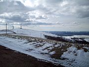
Aspen Mountain is a long mountain located approximately 12 miles (19.3 km) south of Rock Springs, Wyoming
and 5.5 miles (8.9 km) south of Arrowhead Springs
, in Sweetwater County. The mountain gets its name from patches of Quaking Aspen trees located on the north and southern faces of the mountain. Various older topographical maps name the mountain "Quaking Aspen Mountain". Its primary use is for radio communications and it houses towers for various local and state companies.
 Aspen Mountain also houses repeaters used by local highway patrol
and local police and fire services for Sweetwater County, which are also present on nearby Wilkins Peak
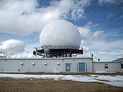
. If the local emergency repeaters on Aspen Mountain fail, they are automatically switched to the Wilkins Peak repeaters, and vice versa. The mountain also houses amateur radio repeaters, and a long range radar station (operated by the FAA
) is the mountain's most visible feature.
in the center of the Greater Green River Basin. It is part of the Rock Springs Uplift, an area of uplifted Cretaceous
to Tertiary
rocks surrounded by the Green River Formation
, formed in the so called Lake Gosiute. The Rock Springs Uplift formed in the Late Cretaceous by large-scale folding. Aspen Mountain is composed of Miocene
deposits.
. From the south, the mountain can be accessed via US 191. The roads are usually in good condition year round, weather permitting. Travel is still possible during winter months, but a four wheel drive vehicle is recommended. The road on the mountain itself is known as "Radar Tower Road."
Most of the mountain is not off limits, except for various radio towers with fences and the long range radar station, which features no trespassing signs and a fence around its perimeter. The radar site is also manned 24 hours a day, 365 days a year, with up to two employees watching the site at a time. In the winter, their only means of travel is often via Snowcat
s.

K26DK and K45IA were shut down after the digital transition.
Rock Springs, Wyoming
Rock Springs is a city in Sweetwater County, Wyoming, United States. The population was 18,708 at the 2000 census. Rock Springs is the principal city of the Rock Springs micropolitan statistical area, which has a population of 37,975....
and 5.5 miles (8.9 km) south of Arrowhead Springs
Arrowhead Springs, Wyoming
Arrowhead Springs is a census-designated place in Sweetwater County, Wyoming, United States. The population was 68 at the 2000 census.-Geography:Arrowhead Springs is located at ....
, in Sweetwater County. The mountain gets its name from patches of Quaking Aspen trees located on the north and southern faces of the mountain. Various older topographical maps name the mountain "Quaking Aspen Mountain". Its primary use is for radio communications and it houses towers for various local and state companies.
Other uses
Wyoming Highway Patrol
The Wyoming Highway Patrol is the highway patrol agency for Wyoming, which has jurisdiction anywhere in the state. It was created to protect the lives, property and constitutional rights of people in Wyoming...
and local police and fire services for Sweetwater County, which are also present on nearby Wilkins Peak
Wilkins Peak
Wilkins Peak is a small mountain located in Sweetwater County, Wyoming, between the cities of Green River and Rock Springs. It is primarily used for radio and television station transmitters, but it also serves radio needs of the FAA, EMS, and local businesses such as Questar Gas. In 2003, a tower...
. If the local emergency repeaters on Aspen Mountain fail, they are automatically switched to the Wilkins Peak repeaters, and vice versa. The mountain also houses amateur radio repeaters, and a long range radar station (operated by the FAA
Federal Aviation Administration
The Federal Aviation Administration is the national aviation authority of the United States. An agency of the United States Department of Transportation, it has authority to regulate and oversee all aspects of civil aviation in the U.S...
) is the mountain's most visible feature.
Geology
Aspen Mountain lies to the north of the Uinta MountainsUinta Mountains
The Uinta Mountains are a high chain of mountains in northeastern Utah and extreme northwestern Colorado in the United States. A subrange of the Rocky Mountains, they are unusual for being the highest range in the contiguous United States running east to west, and lie approximately east of Salt...
in the center of the Greater Green River Basin. It is part of the Rock Springs Uplift, an area of uplifted Cretaceous
Cretaceous
The Cretaceous , derived from the Latin "creta" , usually abbreviated K for its German translation Kreide , is a geologic period and system from circa to million years ago. In the geologic timescale, the Cretaceous follows the Jurassic period and is followed by the Paleogene period of the...
to Tertiary
Tertiary
The Tertiary is a deprecated term for a geologic period 65 million to 2.6 million years ago. The Tertiary covered the time span between the superseded Secondary period and the Quaternary...
rocks surrounded by the Green River Formation
Green River Formation
The Green River Formation is an Eocene geologic formation that records the sedimentation in a group of intermountain lakes. The sediments are deposited in very fine layers, a dark layer during the growing season and a light-hue inorganic layer in winter. Each pair of layers is called a varve and...
, formed in the so called Lake Gosiute. The Rock Springs Uplift formed in the Late Cretaceous by large-scale folding. Aspen Mountain is composed of Miocene
Miocene
The Miocene is a geological epoch of the Neogene Period and extends from about . The Miocene was named by Sir Charles Lyell. Its name comes from the Greek words and and means "less recent" because it has 18% fewer modern sea invertebrates than the Pliocene. The Miocene follows the Oligocene...
deposits.
Access
Aspen Mountain can be accessed via a number of routes. From Rock Springs, access starts from Blairtown/Flaming Gorge Road, and begins on a road known as Little Bitter Creek Road. Aspen Mountain can also be accessed via county highway 4-27, which begins on Wyoming Highway 430Wyoming Highway 430
Wyoming Highway 430 is a state road in south-central Sweetwater County, Wyoming that runs from the Wyoming-Colorado State Line to Rock Springs.-Route description:...
. From the south, the mountain can be accessed via US 191. The roads are usually in good condition year round, weather permitting. Travel is still possible during winter months, but a four wheel drive vehicle is recommended. The road on the mountain itself is known as "Radar Tower Road."
Most of the mountain is not off limits, except for various radio towers with fences and the long range radar station, which features no trespassing signs and a fence around its perimeter. The radar site is also manned 24 hours a day, 365 days a year, with up to two employees watching the site at a time. In the winter, their only means of travel is often via Snowcat
Snowcat
A snowcat is an enclosed-cab, truck sized, fully tracked vehicle designed to move on snow. Snowcats are often referred to as 'trail groomers' because of their use for grooming ski trails or snowmobile trails...
s.
Radio and television stations
- KZUWKZUWKZUW is a classical music radio station licensed to Reliance, Wyoming. The station is owned and operated by the University of Wyoming.-Signal:...
88.5 FMFM broadcastingFM broadcasting is a broadcasting technology pioneered by Edwin Howard Armstrong which uses frequency modulation to provide high-fidelity sound over broadcast radio. The term "FM band" describes the "frequency band in which FM is used for broadcasting"...
- Licensed to RelianceReliance, WyomingReliance is a census-designated place in Sweetwater County, Wyoming, United States. The population was 665 at the 2000 census.-Geography:Reliance is located at ....
. - KUWZKUWZKUWZ is a radio station licensed to Rock Springs, Wyoming. The station is owned by the University of Wyoming, and is an affiliate of Wyoming Public Radio , airing a format consisting of news, jazz, adult album alternative and classical music originating from KUWR in Laramie, Wyoming.-External...
90.5 FM - Licensed to Rock Springs. - KQSWKQSWKQSW is a country music formatted radio station broadcasting from Rock Springs, Wyoming, serving southwestern Wyoming. The station is owned by Big Thicket Broadcasting of Wyoming, who sometimes identifies themselves as WyoRadio, which includes local sister stations KSIT, KMRZ and KRKK.-Signal:Like...
96.5 FM - Licensed to Rock Springs. - KSITKSITKSIT is an American radio station licensed to serve the community of Rock Springs, Wyoming. KSIT's sister stations are KQSW 96.5, KRKK AM 1360, and KMRZ.-History:...
99.7 FM - Also licensed to Rock Springs (Both FM stations are located on the eastern half of the mountain, near the radar site). - KMRZ-FM 106.7 FM - Licensed to Superior, WyomingSuperior, WyomingSuperior is a town in Sweetwater County, Wyoming, United States. The population was 244 at the 2000 census.-Notable people:*Former Wyoming Supreme Court Justice Richard V...
, is the only FM station with a tower on the western half of the mountain. - KGWR Channel 13 -CBSKGWC-TVKGWC-TV channel 14 is the local CBS affiliate for Casper, Wyoming, owned by Mark III Media. Programming is repeated on its satellite stations, KGWL-TV digital channel 7 in Lander, and KGWR-TV channel 13 in Rock Springs...
- Rock Springs (Far eastern side of the mountain, second tower from east). - K26DK Channel 25 -KJZZKJZZ-TVKJZZ-TV, virtual channel 14, is a full-service Independent television station serving Salt Lake City, Utah, USA and surrounding areas, broadcasting in digital on UHF channel 46. The KJZZ transmitter is located on Farnsworth Peak in the Oquirrh Mountains...
- Rock Springs - K45IA Channel 45 -The CWKUCWKUCW is the CW-afifliated television station for the state of Utah that is licensed to Ogden. It broadcasts a high definition digital signal on UHF channel 48 from a transmitter on Farnsworth Peak. Owned by High Plains Broadcasting, the station is operated through joint sales and shared services...
- Rock Springs - KXI34KXI34KXI34 is a NOAA Weather Radio station that is programmed from the National Weather Service forecast office in Riverton, Wyoming with its transmitter located on Aspen Mountain south of Rock Springs. KXI34 broadcasts weather information for the cities of Rock Springs and Green River, Wyoming...
162.550 MHz- NOAA Weather Radio - Operated by the RivertonRiverton, WyomingRiverton is a city in Fremont County, Wyoming, United States. It is both the largest city in the county and the largest within the historical boundaries of the Wind River Indian Reservation. The city's population was 9,310 at the 2000 census...
National Weather ServiceNational Weather ServiceThe National Weather Service , once known as the Weather Bureau, is one of the six scientific agencies that make up the National Oceanic and Atmospheric Administration of the United States government...
office.
K26DK and K45IA were shut down after the digital transition.
External links
- Green River Basin. (Geological) by King, Clarence from 1876, David Rumsey Historical Map Collection
- Aspen Mountain FM/TV only Radio Tower Locations and Info (RTLI).