
Whanganui Journey
Encyclopedia
The Whanganui Journey is a river journey along the Whanganui River
in the North Island
of New Zealand
travelling by canoe
or kayak
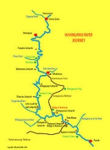
. The route, starting at Taumarunui
and finishing at Pipiriki, is 145 km long and usually takes 5 days to complete. The route is managed by New Zealand's Department of Conservation
under its Great Walks
programme and much of the route travels through land which is part of the Whanganui National Park
.
Although the Great Walk route ends at Pipiriki, the river is navigable for a further 89 km and a small number of canoeists continue to exit at the main bridge in Wanganui
, which takes a further two days. If planning to travel through to Wanganui, make sure you check the tide timetable so that you leave Hipango Park on an outgoing tide.
 The route is broken into sections which are
stretches of river between camp sites/huts as follows:-
During normal weather conditions the rapids on the river will not
exceed grade II.
As a result, there are several tour operators that offer a variety
of trip combinations covering all, or part of the route.
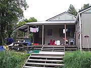 Accommodation on the route is a combination of huts and campsites which cannot be booked. All river users must purchased a Facilities User Pass (FUP) if travelling on the river between 1 October and 30 April. It is cheaper to purchase the FUP before you go on the river. They are available from the various operators, DOC in Wanganui, and from local Visitor Information Centres (VINs). There are different rates for different age groups, and for jetboaters. Full information can be found on the DOC website as listed in the external links below.
Whanganui River
The Whanganui River is a major river in the North Island of New Zealand.Known for many years as the Wanganui River, the river's name reverted to Whanganui in 1991, according with the wishes of local iwi. Part of the reason was also to avoid confusion with the Wanganui River in the South Island...
in the North Island
North Island
The North Island is one of the two main islands of New Zealand, separated from the much less populous South Island by Cook Strait. The island is in area, making it the world's 14th-largest island...
of New Zealand
New Zealand
New Zealand is an island country in the south-western Pacific Ocean comprising two main landmasses and numerous smaller islands. The country is situated some east of Australia across the Tasman Sea, and roughly south of the Pacific island nations of New Caledonia, Fiji, and Tonga...
travelling by canoe
Canoe
A canoe or Canadian canoe is a small narrow boat, typically human-powered, though it may also be powered by sails or small electric or gas motors. Canoes are usually pointed at both bow and stern and are normally open on top, but can be decked over A canoe (North American English) or Canadian...
or kayak
Kayak
A kayak is a small, relatively narrow, human-powered boat primarily designed to be manually propelled by means of a double blade paddle.The traditional kayak has a covered deck and one or more cockpits, each seating one paddler...
. The route, starting at Taumarunui
Taumarunui
Taumarunui is a town in the King Country of the central North Island of New Zealand. It is on State Highway 4 and the North Island Main Trunk Railway....
and finishing at Pipiriki, is 145 km long and usually takes 5 days to complete. The route is managed by New Zealand's Department of Conservation
New Zealand Department of Conservation
The Department of Conservation , commonly known by its acronym, "DOC", is the state sector organisation which deals with the conservation of New Zealand’s natural and historic heritage...
under its Great Walks
New Zealand Great Walks
The New Zealand Great Walks are a set of popular tramping tracks. They are New Zealand's premier tracks, through areas of some of the best scenery in the country...
programme and much of the route travels through land which is part of the Whanganui National Park
Whanganui National Park
The Whanganui National Park is a national park located in the North Island of New Zealand. Established in 1986, it covers an area of 742 km² bordering the Whanganui River. It incorporates areas of Crown land, former state forest and a number of former reserves. The river itself is not part of the...
.
Although the Great Walk route ends at Pipiriki, the river is navigable for a further 89 km and a small number of canoeists continue to exit at the main bridge in Wanganui
Wanganui
Whanganui , also spelled Wanganui, is an urban area and district on the west coast of the North Island of New Zealand. It is part of the Manawatu-Wanganui region....
, which takes a further two days. If planning to travel through to Wanganui, make sure you check the tide timetable so that you leave Hipango Park on an outgoing tide.
Route description
stretches of river between camp sites/huts as follows:-
- Taumarunui to Ohinepane : 21.5 km
- Ohinepane to Poukaria : 14 km
- Poukaria to Maharanui : 17.5 km
- Maharanui to Whakahoro : 5 km
- Whakahoro to Mangapapa : 10 km
- Mangapapa to Ohauora : 15 km
- Ohauora to John Coull Hut : 12.5 km
- John Coull Hut to Mangawaiiti : 9.5 km
- Mangawaiiti to Mangapurua : 9 km
- Mangapurua to Tieke KāingaTieke KaingaTieke Kāinga is a small Māori community in New Zealand, on the middle reaches of the Whanganui River 10.5 km downstream of the Mangapurua valley. It is centered around Tieke Marae, a converted Department of Conservation tramping hut...
: 10.5 km - Tieke to Ngaporo : 12 km
- Ngaporo to Pipiriki : 9.5 km
During normal weather conditions the rapids on the river will not
exceed grade II.
As a result, there are several tour operators that offer a variety
of trip combinations covering all, or part of the route.
Accommodation
External links
- Department of Conservation information on Whanganui National Park
- Te Whanau o Tieke A photo exhibition by photographer Fraser Harding on the Whanganui River