

Dartmouth, Massachusetts
Encyclopedia
Dartmouth is a town
in Bristol County
, Massachusetts
, United States
established in 1664. The population was 30,665 at the 2000 census. It is the location of the University of Massachusetts Dartmouth
.
The villages of Hixville Village Historic District
, Bliss Corner
, Padanaram Village
, Smith Mills
and Russells Mills Village Historic District
are located in the town.
, Devon
, England, where the Puritans originally intended to leave from for America. The land was purchased with trading goods from the Wampanoag chiefs Massasoit
and Wamsutta
by elders of the Plymouth Colony
; reportedly thirty yards of cloth, eight moose skins, fifteen axes, fifteen hoes, fifteen pairs of shoes, one iron pot, and ten shillings' worth of assorted goods . It was sold to the Religious Society of Friends
or Quakers, who wished to live outside the stringent religious laws of the Puritans in Plymouth. There are still Quaker meeting houses in town, including the Smith Neck Meeting House, the Allens Neck Meeting House, and the Apponegansett Meeting House, which is on the National Register of Historic Places
. Its borders were originally named in the charter (and set by King Philip
) as the lands of "Acushnea, Ponagansett, and Coaksett." This includes the land of the towns of Westport
, Fairhaven
, and Acushnet
, and the city of New Bedford
. In 1789, the towns of Westport and New Bedford, which included Fairhaven and Acushnet, separated and were incorporated as towns themselves.
In 1780, seven black residents of Dartmouth petitioned the town's legislature for the right to vote, claiming a lack of representation despite the fact that they paid taxes and fought in the Revolutionary War.
Dartmouth's history was that of an agricultural community, but during the late 19th century its coastline became a resort area for the wealthy members of New Bedford society.
Round Hill
was the site of early-to-mid 20th century research into the uses of radio
and microwaves for aviation
and communication
by MIT researchers. It is also the site of the Green Mansion, the estate of "Colonel" Edward Howland Robinson Green
, a colorful character in his own right, who was son of the even more colorful and wildly eccentric Hetty Green
, said to be the richest woman in the world in her time, who is listed in the Guinness book of records as the "world's greatest miser". In 1936 the Colonel died and the estate fell into disrepair as litigation between his wife and his sister continued for eight years over his vast fortune. Finally, Mrs. Hetty Sylvia Wilks, the Colonel's sister, was ruled the sole beneficiary. In 1948, she bequeathed the entire estate to MIT, which used it for microwave and laser experiments. The giant antenna, which was a landmark to sailors on Buzzards Bay
, was erected on top of a 50 thousand-gallon water tank. (after all efforts were made to preserve the structure, it was demolished on November 19, 2007.) Another antenna was erected next to the mansion and used in the development of the Ballistic Early Warning System. MIT continued to use Round Hill through 1964. It was then sold to the Society of Jesus
of New England. It was used as a retreat house. The upper floors were divided into 64 individual rooms. The main floor was fitted with a Chapel, a library and meeting rooms. In 1970, the Jesuits sold the land and buildings to Gratia R. Montgomery. In 1981, Mrs. Montgomery sold most of the land to a group of developers who have worked to preserve the history, grandeur and natural environment. The property now is a gated community featuring a nine hole golf course.
The town's retail area has grown steadily since the 1960s, centering around the village of Smith Mills, but many of those stores have closed down now. Business is now branching northward towards Faunce Corners, now the home of the Dartmouth Mall
.
The Lloyd Center for Environmental Studies
, located in South Dartmouth, is a non-profit organization that provides educational programs on aquatic environments in southeastern New England. It is across the mouth of Slocums River
from Demarest Lloyd State Park
, a popular state beach known for its shallow waters.
The town was also once the home of Lincoln Park, a former amusement park which dated from the late 19th century as a park-stop along the trolley line from Fall River to New Bedford just east of the junction of Lake Noquochoke and the Westport River. The park closed in 1986 due to sagging attendance and lack of funds. Much of the park was burned to the ground in several incidents of arson, and today there are plans to turn the former park's lands into a housing development with accompanying stores.
, the town has a total area of 97.8 square miles (253.3 km²). 61.6 square miles (159.5 km²) of it is land and 36.2 square miles (93.8 km²) of it (37.06%) is water. Geographically, it is the 3rd largest town in Massachusetts.
The town is accessible by Interstate 195
and US Route 6, both of which run parallel through the town on an east-west axis. Route 140
is located just over the New Bedford Line and is accessible by US Route 6, and Interstate 195
. Route 177 also lies to the edge of town (in Dartmouth) on the border with Westport, accessible by Route 6 near Lake Noquochoke and the Westport River's source. Route 177 runs south into Rhode Island. Routes 177, 140 and 195 are based upon old Indian routes and trails. Dartmouth includes Southeastern Massachusetts Bioreserve that extends from Fall River into many protected forests of North Dartmouth in the Collins Corner, Faunce Corner and Hixville Sections of town.
There are many rivers that flow North/South in Dartmouth such as the Copicut River
, Shingle Island River, Paskamanset River
, Slocums River
, Destruction Brook, and Little River. Dartmouth is divided into two primary sections: North Dartmouth (USPS
ZIP code
02747) and South Dartmouth (USPS ZIP code 02748). The use of "North" and "South" is no longer official, only colloquial.
The town is bordered by Westport
to the west, New Bedford
to the east, Fall River
to the north and Buzzard's Bay to the south.
of 2000, there were 30,666 people, 10,555 households, and 7,821 families residing in the town. The population density
was 498.1 inhabitants per square mile (192.3/km²). There were 11,283 housing units at an average density of 183.3 per square mile (70.8/km²). The racial makeup of the town was 90.77% Caucasian, 1.06% African American, 0.20% Native American, 1.18% Asian, 0.03% Pacific Islander, 5.12% from other races
, and 1.64% from two or more races. Hispanic or Latino of any race were 1.50% of the population.
There were 10,555 households out of which 31.9% had children under the age of 18 living with them, 61.3% were married couples
living together, 9.6% had a female householder with no husband present, and 25.9% were non-families. 22.3% of all households were made up of individuals and 12.5% had someone living alone who was 65 years of age or older. The average household size was 2.60 and the average family size was 3.06.
In the town the population was spread out with 20.4% under the age of 18, 14.1% from 18 to 24, 25.8% from 25 to 44, 24.2% from 45 to 64, and 15.5% who were 65 years of age or older. The median age was 38 years. For every 100 females there were 97.7 males. For every 100 females age 18 and over, there were 96.0 males.
The median income for a household in the town was $50,742, and the median income for a family was $60,401. Males had a median income of $39,788 versus $28,033 for females. The per capita income
for the town was $24,326. About 2.8% of families and 4.5% of the population were below the poverty line, including 3.6% of those under age 18 and 8.3% of those age 65 or over.
and the state's senior (Class II) Senator, up for re-election in 2014, is John F. Kerry.
Dartmouth is governed by a representative town meeting form of government, led by a board of selectmen. The Town Hall is located in the former Poole School, which also served as Dartmouth High School for several years. The town is patrolled by a central police department, located in the former Town Hall near the village of Padanaram. There are five fire stations in the town divided among three fire districts, all of which are paid-call departments. There are two post offices (North Dartmouth, under the 02747 zip code, and South Dartmouth, under the 02748 zip code).
 Dartmouth is governed by a single school department (dartmouthps.schoolfusion.us) whose headquarters are in the former Bush Street School in Padanaram. The school department has been experiencing many changes in the past decade, with the opening of a new high school, the moving of the former Middle School to the High School, and two venerable elementary schools - Job S. Gidley (the town's longest serving school) and Andrew B. Cushman - closing in 2007. The town currently has three elementary schools, Joseph P. DeMello, George H. Potter, and James M. Quinn. Potter and DeMello both were opened in 1955 and are mirror images of each other, with Quinn, currently one of the largest elementary schools by population in Massachusetts, opening in 2002 in the former middle school building. All three elementary schools serve students from kindergarten through fifth grade, with Quinn also serving pre-kindergarten students. The town has one middle school (located in the 1955-vintage High School building) next to the Town Hall, and one high school, the new Dartmouth High School, which opened in 2002 in the southern part of town. Its colors are Dartmouth green and white, and its fight song is "Glory to Dartmouth;" unlike the college, however, the school still uses the "Indians" nickname, with a stylized brave's head in profile as the logo.
DHS's most prominent group is the Dartmouth High School Marching Band, the current national champions in the USSBA marching band circuit and WGI indoor percussion circuit. They have won numerous state and regional titles in marching band field show and indoor percussion show competitions dating back to the 1970s, first under the direction of Gilbert A. Madrigale, and currently under the direction of William R. Kingsland. The assistant band director, Thomas Aungst, was the former percussion caption head for The Cadets Drum and Bugle Corps
until 2008, and the music department has also had ties to the Boston Crusaders in the past. The band has appeared in the Tournament of Roses Parade
(1996), the National Cherry Blossom Festival
parade, the Shenandoah Apple Blossom Festival
parade and field show competition (which it won for three consecutive years, 1990–92), as well as several other festivals and Disney Magic Music Days at Walt Disney World. The Indoor Percussion ensemble has also captured four WGI (Winter Guard International) championships and has placed in the top three since 1998. The Dartmouth High School Orchestra has also come to local prominence in recent years under the direction of Heather Church-Yarmac, traveling to and performing in the Azores, Ireland, and most recently Canada. Dartmouth High school also has a large drama department, they have put on shows such as "A Christmas Carol" and "Grease" in 2009. The school also has competitive MIAA Division I athletics, having won several state titles in different sports and given rise to former major league pitcher Brian Rose and former North Carolina Tar Heel basketball player Jess Gaspar along with UCONN Football star Jordan Todman and Georgia's Arthur Lynch.
In addition to DHS, students may also attend Greater New Bedford Regional Vocational-Technical High School or Bristol County Agricultural High School. The town is also home to Bishop Stang High School, named for the first Bishop of the Diocese of Fall River, William Stang, and Friends Academy, a private K-8 school affiliated with the Religious Society of Friends
.
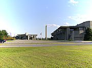
Since the 1960s, Dartmouth has been home to the University of Massachusetts Dartmouth
campus, located on Old Westport Road, just southwest of the Smith Mills section of town. The campus was the result of the unification of the Bradford Durfee College of Technology
in Fall River and the New Bedford Institute of Textiles and Technology in New Bedford in 1962 to form the Southeastern Massachusetts Technological Institute. The campus itself was begun in 1964 and its unique Brutalist design was created by Paul Rudolph
, then the head of Yale's School of Architecture. From 1969 until its inclusion into the University of Massachusetts
system in 1991, the school was known as Southeastern Massachusetts University, reflecting the school's expansion into liberal arts. The campus has expanded over the years to its current size, with several sub-centers located in Fall River and New Bedford.
New England town
The New England town is the basic unit of local government in each of the six New England states. Without a direct counterpart in most other U.S. states, New England towns are conceptually similar to civil townships in other states, but are incorporated, possessing powers like cities in other...
in Bristol County
Bristol County, Massachusetts
-Demographics:As of the census of 2000, there were 534,678 people, 205,411 households, and 140,706 families residing in the county. The population density was 962 people per square mile . There were 216,918 housing units at an average density of 390 per square mile...
, Massachusetts
Massachusetts
The Commonwealth of Massachusetts is a state in the New England region of the northeastern United States of America. It is bordered by Rhode Island and Connecticut to the south, New York to the west, and Vermont and New Hampshire to the north; at its east lies the Atlantic Ocean. As of the 2010...
, United States
United States
The United States of America is a federal constitutional republic comprising fifty states and a federal district...
established in 1664. The population was 30,665 at the 2000 census. It is the location of the University of Massachusetts Dartmouth
University of Massachusetts Dartmouth
The University of Massachusetts Dartmouth is one of five campuses and operating subdivisions of the University of Massachusetts . It is located in North Dartmouth, Massachusetts, United States, in the center of the South Coast region, between the cities of New Bedford to the east and Fall River...
.
The villages of Hixville Village Historic District
Hixville Village Historic District
Hixville Village Historic District is a historic district at the junction of Old Fall River, Hixville and North Hixville Roads in Dartmouth, Massachusetts.The district was founded in 1785 and added to the National Register of Historic Places in 1991....
, Bliss Corner
Bliss Corner, Massachusetts
Bliss Corner is a census-designated place in the town of Dartmouth in Bristol County, Massachusetts, United States. The population was 5,466 at the 2000 census.-Geography:Bliss Corner is located at ....
, Padanaram Village
Padanaram
Padanaram is a village in South Dartmouth, Massachusetts, Bristol County, Massachusetts, United States. It lies along the Apponagansett River or Apponagansett Bay....
, Smith Mills
Smith Mills, Massachusetts
Smith Mills is a census-designated place in the town of Dartmouth in Bristol County, Massachusetts, United States. The population was 4,432 at the 2000 census.-Geography:Smith Mills is located at ....
and Russells Mills Village Historic District
Russells Mills Village Historic District
Russells Mills Village Historic District is a historic district on Russells Mills, Rock O' Dundee, Slades Corner, Horseneck and Fisher Roads in Dartmouth, Massachusetts.The district was added to the National Register of Historic Places in 1985.-References:...
are located in the town.
History
Dartmouth was the first settled in 1652 and was officially incorporated in 1664. It was named for the town of DartmouthDartmouth, Devon
Dartmouth is a town and civil parish in the English county of Devon. It is a tourist destination set on the banks of the estuary of the River Dart, which is a long narrow tidal ria that runs inland as far as Totnes...
, Devon
Devon
Devon is a large county in southwestern England. The county is sometimes referred to as Devonshire, although the term is rarely used inside the county itself as the county has never been officially "shired", it often indicates a traditional or historical context.The county shares borders with...
, England, where the Puritans originally intended to leave from for America. The land was purchased with trading goods from the Wampanoag chiefs Massasoit
Massasoit
Massasoit Sachem or Ousamequin ,was the sachem, or leader, of the Pokanoket, and "Massasoit" of the Wampanoag Confederacy. The term Massasoit means Great Sachem.-Early years:...
and Wamsutta
Wamsutta
Wamsutta , also known as Alexander Pokanoket, as he was called by New England colonists, was the eldest son of Massasoit and a sachem of the Wampanoag native American tribe. His sale of Wampanoag lands to colonists other than those of the Plymouth Colony brought the Wampanoag considerable power,...
by elders of the Plymouth Colony
Plymouth Colony
Plymouth Colony was an English colonial venture in North America from 1620 to 1691. The first settlement of the Plymouth Colony was at New Plymouth, a location previously surveyed and named by Captain John Smith. The settlement, which served as the capital of the colony, is today the modern town...
; reportedly thirty yards of cloth, eight moose skins, fifteen axes, fifteen hoes, fifteen pairs of shoes, one iron pot, and ten shillings' worth of assorted goods . It was sold to the Religious Society of Friends
Religious Society of Friends
The Religious Society of Friends, or Friends Church, is a Christian movement which stresses the doctrine of the priesthood of all believers. Members are known as Friends, or popularly as Quakers. It is made of independent organisations, which have split from one another due to doctrinal differences...
or Quakers, who wished to live outside the stringent religious laws of the Puritans in Plymouth. There are still Quaker meeting houses in town, including the Smith Neck Meeting House, the Allens Neck Meeting House, and the Apponegansett Meeting House, which is on the National Register of Historic Places
National Register of Historic Places
The National Register of Historic Places is the United States government's official list of districts, sites, buildings, structures, and objects deemed worthy of preservation...
. Its borders were originally named in the charter (and set by King Philip
Metacomet
Metacomet , also known as King Philip or Metacom, or occasionally Pometacom, was a war chief or sachem of the Wampanoag Indians and their leader in King Philip's War, a widespread Native American uprising against English colonists in New England.-Biography:Metacomet was the second son of Massasoit...
) as the lands of "Acushnea, Ponagansett, and Coaksett." This includes the land of the towns of Westport
Westport, Massachusetts
Westport is a town in Bristol County, Massachusetts, United States. The population was 15,532 at the 2010 census.The village of North Westport lies in the town.- History :...
, Fairhaven
Fairhaven, Massachusetts
Fairhaven is a town in Bristol County, Massachusetts, in the United States. It is located on the south coast of Massachusetts where the Acushnet River flows into Buzzards Bay, an arm of the Atlantic Ocean...
, and Acushnet
Acushnet, Massachusetts
Acushnet is a town in Bristol County, Massachusetts, United States. The population was 10,303 at the 2010 census.- History :Acushnet was first settled in 1659. It has been included as a part of three separate towns throughout its history. It was formerly the northeastern section of the town of...
, and the city of New Bedford
New Bedford, Massachusetts
New Bedford is a city in Bristol County, Massachusetts, United States, located south of Boston, southeast of Providence, Rhode Island, and about east of Fall River. As of the 2010 census, the city had a total population of 95,072, making it the sixth-largest city in Massachusetts...
. In 1789, the towns of Westport and New Bedford, which included Fairhaven and Acushnet, separated and were incorporated as towns themselves.
In 1780, seven black residents of Dartmouth petitioned the town's legislature for the right to vote, claiming a lack of representation despite the fact that they paid taxes and fought in the Revolutionary War.
Dartmouth's history was that of an agricultural community, but during the late 19th century its coastline became a resort area for the wealthy members of New Bedford society.
Round Hill
Round Hill, Massachusetts
Round Hill is a location in Dartmouth, Massachusetts of historical significance.- History :Edward Howland Robinson Green, known as "Colonel" Ned Green, the only son of the renowned female tycoon and miser, Hetty Green, built his home on Round Hill after his mother's death in 1916 left him with a...
was the site of early-to-mid 20th century research into the uses of radio
Radio
Radio is the transmission of signals through free space by modulation of electromagnetic waves with frequencies below those of visible light. Electromagnetic radiation travels by means of oscillating electromagnetic fields that pass through the air and the vacuum of space...
and microwaves for aviation
Aviation
Aviation is the design, development, production, operation, and use of aircraft, especially heavier-than-air aircraft. Aviation is derived from avis, the Latin word for bird.-History:...
and communication
Communication
Communication is the activity of conveying meaningful information. Communication requires a sender, a message, and an intended recipient, although the receiver need not be present or aware of the sender's intent to communicate at the time of communication; thus communication can occur across vast...
by MIT researchers. It is also the site of the Green Mansion, the estate of "Colonel" Edward Howland Robinson Green
Edward Howland Robinson Green
Edward Howland Robinson "Ned" Green , also known as Colonel Green, was an American businessman, the only son of the notorious miser Hetty Green . He was also noted for his stamp and coin collections.-Biography:Edward Green was the first of two children of Hetty and Edward Henry Green...
, a colorful character in his own right, who was son of the even more colorful and wildly eccentric Hetty Green
Hetty Green
Hetty Green , nicknamed "The Witch of Wall Street" , was an American businesswoman, remarkable for her frugality during the Gilded Age, as well as for being the first American woman to make a substantial impact on Wall Street.-Birth and early years:She was born Henrietta Howland Robinson in New...
, said to be the richest woman in the world in her time, who is listed in the Guinness book of records as the "world's greatest miser". In 1936 the Colonel died and the estate fell into disrepair as litigation between his wife and his sister continued for eight years over his vast fortune. Finally, Mrs. Hetty Sylvia Wilks, the Colonel's sister, was ruled the sole beneficiary. In 1948, she bequeathed the entire estate to MIT, which used it for microwave and laser experiments. The giant antenna, which was a landmark to sailors on Buzzards Bay
Buzzards Bay
Buzzards Bay is a bay along the southern edge of Massachusetts in the United States. The name may also refer to:*Buzzards Bay, Massachusetts, a village in Bourne, Massachusetts*Buzzards Bay , the name of the horse that won the 2005 Santa Anita Derby...
, was erected on top of a 50 thousand-gallon water tank. (after all efforts were made to preserve the structure, it was demolished on November 19, 2007.) Another antenna was erected next to the mansion and used in the development of the Ballistic Early Warning System. MIT continued to use Round Hill through 1964. It was then sold to the Society of Jesus
Society of Jesus
The Society of Jesus is a Catholic male religious order that follows the teachings of the Catholic Church. The members are called Jesuits, and are also known colloquially as "God's Army" and as "The Company," these being references to founder Ignatius of Loyola's military background and a...
of New England. It was used as a retreat house. The upper floors were divided into 64 individual rooms. The main floor was fitted with a Chapel, a library and meeting rooms. In 1970, the Jesuits sold the land and buildings to Gratia R. Montgomery. In 1981, Mrs. Montgomery sold most of the land to a group of developers who have worked to preserve the history, grandeur and natural environment. The property now is a gated community featuring a nine hole golf course.
The town's retail area has grown steadily since the 1960s, centering around the village of Smith Mills, but many of those stores have closed down now. Business is now branching northward towards Faunce Corners, now the home of the Dartmouth Mall
Dartmouth Mall
The Dartmouth Mall is a one-level, two-story, indoor shopping mall located off US 6 and Faunce Corner Road in North Dartmouth, Massachusetts, in the United States. Currently anchoring the mall are JC Penney, Macy's, and Sears. The mall also features a food court and movie theater...
.
The Lloyd Center for Environmental Studies
Lloyd Center for Environmental Studies
The Lloyd Center for Environmental Studies is a non-profit organization that provides educational programs on aquatic environments in southeastern New England in the United States....
, located in South Dartmouth, is a non-profit organization that provides educational programs on aquatic environments in southeastern New England. It is across the mouth of Slocums River
Slocums River
Slocums River is a tidal river in southeastern Massachusetts in the United States...
from Demarest Lloyd State Park
Demarest Lloyd State Park
Demarest Lloyd State Park is a Massachusetts state park located in Dartmouth. The park is managed by the Department of Conservation and Recreation .-Description:...
, a popular state beach known for its shallow waters.
The town was also once the home of Lincoln Park, a former amusement park which dated from the late 19th century as a park-stop along the trolley line from Fall River to New Bedford just east of the junction of Lake Noquochoke and the Westport River. The park closed in 1986 due to sagging attendance and lack of funds. Much of the park was burned to the ground in several incidents of arson, and today there are plans to turn the former park's lands into a housing development with accompanying stores.
Geography
According to the United States Census BureauUnited States Census Bureau
The United States Census Bureau is the government agency that is responsible for the United States Census. It also gathers other national demographic and economic data...
, the town has a total area of 97.8 square miles (253.3 km²). 61.6 square miles (159.5 km²) of it is land and 36.2 square miles (93.8 km²) of it (37.06%) is water. Geographically, it is the 3rd largest town in Massachusetts.
The town is accessible by Interstate 195
Interstate 195 (Rhode Island-Massachusetts)
Interstate 195 is an Interstate Highway running a combined 40.1 miles in the U.S. states of Massachusetts and Rhode Island. It travels from a junction with Interstate 95 in Providence, Rhode Island east to a junction with Interstate 495 and Route 25 in Wareham, Massachusetts...
and US Route 6, both of which run parallel through the town on an east-west axis. Route 140
Route 140 (Massachusetts)
Route 140 is a long state highway which passes through parts of southeastern and central Massachusetts. The highway follows a southeast-northwest trajectory, running from U.S...
is located just over the New Bedford Line and is accessible by US Route 6, and Interstate 195
Interstate 195 (Rhode Island-Massachusetts)
Interstate 195 is an Interstate Highway running a combined 40.1 miles in the U.S. states of Massachusetts and Rhode Island. It travels from a junction with Interstate 95 in Providence, Rhode Island east to a junction with Interstate 495 and Route 25 in Wareham, Massachusetts...
. Route 177 also lies to the edge of town (in Dartmouth) on the border with Westport, accessible by Route 6 near Lake Noquochoke and the Westport River's source. Route 177 runs south into Rhode Island. Routes 177, 140 and 195 are based upon old Indian routes and trails. Dartmouth includes Southeastern Massachusetts Bioreserve that extends from Fall River into many protected forests of North Dartmouth in the Collins Corner, Faunce Corner and Hixville Sections of town.
There are many rivers that flow North/South in Dartmouth such as the Copicut River
Copicut River
The Copicut River, or Copecut River, is a stream in the U.S. state of Massachusetts.The river flows south from Copicut Reservoir , in Dartmouth and Fall River, to Cornell Pond near Hixville in Dartmouth...
, Shingle Island River, Paskamanset River
Paskamanset River
The Paskamanset River, also known as the Paskamansett River, is a river in New Bedford and Dartmouth, Massachusetts. The Paskamanset and Slocums River really form just a single river, but the freshwater portion kept its earlier Indian name, while the salt-water portion is named for its English...
, Slocums River
Slocums River
Slocums River is a tidal river in southeastern Massachusetts in the United States...
, Destruction Brook, and Little River. Dartmouth is divided into two primary sections: North Dartmouth (USPS
United States Postal Service
The United States Postal Service is an independent agency of the United States government responsible for providing postal service in the United States...
ZIP code
ZIP Code
ZIP codes are a system of postal codes used by the United States Postal Service since 1963. The term ZIP, an acronym for Zone Improvement Plan, is properly written in capital letters and was chosen to suggest that the mail travels more efficiently, and therefore more quickly, when senders use the...
02747) and South Dartmouth (USPS ZIP code 02748). The use of "North" and "South" is no longer official, only colloquial.
The town is bordered by Westport
Westport, Massachusetts
Westport is a town in Bristol County, Massachusetts, United States. The population was 15,532 at the 2010 census.The village of North Westport lies in the town.- History :...
to the west, New Bedford
New Bedford, Massachusetts
New Bedford is a city in Bristol County, Massachusetts, United States, located south of Boston, southeast of Providence, Rhode Island, and about east of Fall River. As of the 2010 census, the city had a total population of 95,072, making it the sixth-largest city in Massachusetts...
to the east, Fall River
Fall River, Massachusetts
Fall River is a city in Bristol County, Massachusetts, in the United States. It is located about south of Boston, southeast of Providence, Rhode Island, and west of New Bedford and south of Taunton. The city's population was 88,857 during the 2010 census, making it the tenth largest city in...
to the north and Buzzard's Bay to the south.
Demographics
As of the censusCensus
A census is the procedure of systematically acquiring and recording information about the members of a given population. It is a regularly occurring and official count of a particular population. The term is used mostly in connection with national population and housing censuses; other common...
of 2000, there were 30,666 people, 10,555 households, and 7,821 families residing in the town. The population density
Population density
Population density is a measurement of population per unit area or unit volume. It is frequently applied to living organisms, and particularly to humans...
was 498.1 inhabitants per square mile (192.3/km²). There were 11,283 housing units at an average density of 183.3 per square mile (70.8/km²). The racial makeup of the town was 90.77% Caucasian, 1.06% African American, 0.20% Native American, 1.18% Asian, 0.03% Pacific Islander, 5.12% from other races
Race (United States Census)
Race and ethnicity in the United States Census, as defined by the Federal Office of Management and Budget and the United States Census Bureau, are self-identification data items in which residents choose the race or races with which they most closely identify, and indicate whether or not they are...
, and 1.64% from two or more races. Hispanic or Latino of any race were 1.50% of the population.
There were 10,555 households out of which 31.9% had children under the age of 18 living with them, 61.3% were married couples
Marriage
Marriage is a social union or legal contract between people that creates kinship. It is an institution in which interpersonal relationships, usually intimate and sexual, are acknowledged in a variety of ways, depending on the culture or subculture in which it is found...
living together, 9.6% had a female householder with no husband present, and 25.9% were non-families. 22.3% of all households were made up of individuals and 12.5% had someone living alone who was 65 years of age or older. The average household size was 2.60 and the average family size was 3.06.
In the town the population was spread out with 20.4% under the age of 18, 14.1% from 18 to 24, 25.8% from 25 to 44, 24.2% from 45 to 64, and 15.5% who were 65 years of age or older. The median age was 38 years. For every 100 females there were 97.7 males. For every 100 females age 18 and over, there were 96.0 males.
The median income for a household in the town was $50,742, and the median income for a family was $60,401. Males had a median income of $39,788 versus $28,033 for females. The per capita income
Per capita income
Per capita income or income per person is a measure of mean income within an economic aggregate, such as a country or city. It is calculated by taking a measure of all sources of income in the aggregate and dividing it by the total population...
for the town was $24,326. About 2.8% of families and 4.5% of the population were below the poverty line, including 3.6% of those under age 18 and 8.3% of those age 65 or over.
Government
Dartmouth is located in the Ninth Bristol state representative district, which includes all of Dartmouth as well as parts of Freetown, Lakeville and New Bedford. The town is represented in the state senate in the Second Bristol and Plymouth district, which includes the city of New Bedford and the towns of Acushnet, Dartmouth, Fairhaven and Mattapoisett. Dartmouth is the home of the Third Barracks of Troop D of the Massachusetts State Police, which recently relocated from Route 6 to just north of the retail center of town along Faunce Corner Road. On the national level, the town is part of Massachusetts Congressional District 4, which is represented by Barney Frank. The state's junior (Class I) Senator, up for re-election in 2012, is Scott BrownScott Brown
Scott Brown is a United States senator.Scott Brown may also refer to:-Sportsmen:*Scott Brown , American college football coach of Kentucky State...
and the state's senior (Class II) Senator, up for re-election in 2014, is John F. Kerry.
Dartmouth is governed by a representative town meeting form of government, led by a board of selectmen. The Town Hall is located in the former Poole School, which also served as Dartmouth High School for several years. The town is patrolled by a central police department, located in the former Town Hall near the village of Padanaram. There are five fire stations in the town divided among three fire districts, all of which are paid-call departments. There are two post offices (North Dartmouth, under the 02747 zip code, and South Dartmouth, under the 02748 zip code).
Library
Dartmouth established public library services in 1895. Today there are two libraries, the Southworth (Main) Library in South Dartmouth, and the North Dartmouth Library. In fiscal year 2008, the town of Dartmouth spent 1.5% ($865,864) of its budget on its public libraries—some $25 per person.Education
DHS's most prominent group is the Dartmouth High School Marching Band, the current national champions in the USSBA marching band circuit and WGI indoor percussion circuit. They have won numerous state and regional titles in marching band field show and indoor percussion show competitions dating back to the 1970s, first under the direction of Gilbert A. Madrigale, and currently under the direction of William R. Kingsland. The assistant band director, Thomas Aungst, was the former percussion caption head for The Cadets Drum and Bugle Corps
The Cadets Drum and Bugle Corps
The Cadets are a Drum Corps International World Class drum and bugle corps based in Allentown, Pennsylvania...
until 2008, and the music department has also had ties to the Boston Crusaders in the past. The band has appeared in the Tournament of Roses Parade
Tournament of Roses Parade
The Tournament of Roses Parade, better known as the Rose Parade, is "America's New Year Celebration", a festival of flower-covered floats, marching bands, equestrians and a college football game on New Year's Day , produced by the non-profit Pasadena Tournament of Roses Association.The annual...
(1996), the National Cherry Blossom Festival
National Cherry Blossom Festival
The National Cherry Blossom Festival is a spring celebration in Washington, D.C., commemorating the March 27, 1912, gift of Japanese cherry trees from Mayor Yukio Ozaki of Tokyo to the city of Washington...
parade, the Shenandoah Apple Blossom Festival
Shenandoah Apple Blossom Festival
The Shenandoah Apple Blossom Festival, a six-day festival held annually in Winchester, Virginia, is known for its many guest celebrities and events. The festival was first held Saturday, May 3, 1924, and was originally celebrated as a one day event...
parade and field show competition (which it won for three consecutive years, 1990–92), as well as several other festivals and Disney Magic Music Days at Walt Disney World. The Indoor Percussion ensemble has also captured four WGI (Winter Guard International) championships and has placed in the top three since 1998. The Dartmouth High School Orchestra has also come to local prominence in recent years under the direction of Heather Church-Yarmac, traveling to and performing in the Azores, Ireland, and most recently Canada. Dartmouth High school also has a large drama department, they have put on shows such as "A Christmas Carol" and "Grease" in 2009. The school also has competitive MIAA Division I athletics, having won several state titles in different sports and given rise to former major league pitcher Brian Rose and former North Carolina Tar Heel basketball player Jess Gaspar along with UCONN Football star Jordan Todman and Georgia's Arthur Lynch.
In addition to DHS, students may also attend Greater New Bedford Regional Vocational-Technical High School or Bristol County Agricultural High School. The town is also home to Bishop Stang High School, named for the first Bishop of the Diocese of Fall River, William Stang, and Friends Academy, a private K-8 school affiliated with the Religious Society of Friends
Religious Society of Friends
The Religious Society of Friends, or Friends Church, is a Christian movement which stresses the doctrine of the priesthood of all believers. Members are known as Friends, or popularly as Quakers. It is made of independent organisations, which have split from one another due to doctrinal differences...
.
Since the 1960s, Dartmouth has been home to the University of Massachusetts Dartmouth
University of Massachusetts Dartmouth
The University of Massachusetts Dartmouth is one of five campuses and operating subdivisions of the University of Massachusetts . It is located in North Dartmouth, Massachusetts, United States, in the center of the South Coast region, between the cities of New Bedford to the east and Fall River...
campus, located on Old Westport Road, just southwest of the Smith Mills section of town. The campus was the result of the unification of the Bradford Durfee College of Technology
Bradford Durfee College of Technology
The Bradford Durfee College of Technology was a college located in Fall River, Massachusetts. It was chartered in 1895 as the Bradford Durfee Textile School. It was then incorporated in 1899 and opened in 1904.-Creation and beginnings:...
in Fall River and the New Bedford Institute of Textiles and Technology in New Bedford in 1962 to form the Southeastern Massachusetts Technological Institute. The campus itself was begun in 1964 and its unique Brutalist design was created by Paul Rudolph
Paul Rudolph (architect)
Paul Marvin Rudolph was an American architect and the dean of the Yale School of Architecture for six years, known for use of concrete and highly complex floor plans...
, then the head of Yale's School of Architecture. From 1969 until its inclusion into the University of Massachusetts
University of Massachusetts
This article relates to the statewide university system. For the flagship campus often referred to as "UMass", see University of Massachusetts Amherst...
system in 1991, the school was known as Southeastern Massachusetts University, reflecting the school's expansion into liberal arts. The campus has expanded over the years to its current size, with several sub-centers located in Fall River and New Bedford.
Notable residents
- Ezekiel CornellEzekiel CornellEzekiel Cornell represented Rhode Island in the U.S. Continental Congress from 1780 to 1782.Ezekiel Cornell was born in 1732 in either Dartmouth, Massachusetts or Scituate, Rhode Island. He attended the public schools and was employed as a mechanic...
, (1732–1800) member of Continental Congress 1780-1782 - Philip SheridanPhilip SheridanPhilip Henry Sheridan was a career United States Army officer and a Union general in the American Civil War. His career was noted for his rapid rise to major general and his close association with Lt. Gen. Ulysses S...
(March 6, 1831 – August 5, 1888) - career U.S. Army officer and a Union general in the American Civil War. - Brian Rose - (born February 13, 1976) former Major League baseball player
- Tea LeoniTéa LeoniElizabeth Téa Pantaleoni , better known by her stage name Téa Leoni, is an American actress. She has starred in a wide range of films including Jurassic Park III, The Family Man, Deep Impact, Fun with Dick and Jane, Spanglish, Bad Boys, and Ghost Town.-Early life:Leoni was born in New York City...
- (born February 25, 1966) - American film actress (summer resident) (Because she is married to actor David Duchovny, he also can be seen frequenting Dartmouth.) - Arthur GoldenArthur GoldenArthur Golden is an American writer. He is the author of the bestselling novel Memoirs of a Geisha .Golden is a member of the Ochs-Sulzberger family . He was born in Chattanooga, Tennessee, grew up on Lookout Mountain, Georgia, and attended Lookout Mountain Elementary School in Lookout Mountain,...
- Author, Memoirs of a Geisha (summer resident) - Mark Kruger - Season 5 competitor on NBC's The Biggest LoserThe Biggest LoserThe Biggest Loser is an American reality game show that debuted on NBC October 19, 2004. The show features obese people competing to win a cash prize by losing the highest percentage of weight relative to their initial weight....
(4th place)