
West Virginia State Route 9
Encyclopedia
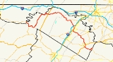
West Virginia Route 9 is a major east–west state highway
located in the eastern extents of West Virginia
's Eastern Panhandle. The western terminus of the route is at the Maryland
state line north of Paw Paw
, where WV 9 becomes Maryland Route 51
upon crossing the Potomac River
. The eastern terminus is at the Virginia
state line at Keyes Gap
near Mannings, West Virginia
, where WV 9 continues onward as State Route 9
.
With no east–west US Highway in the region, WV 9 acts as the major east–west transportation artery between Morgan
, Berkeley
, and Jefferson
counties. WV 9 briefly enters Hampshire County
where it intersects with West Virginia Route 29 near Pin Oak
.
There are three distinct sections for which upgrades are planned - the Virginia
line to Charles Town, Charles Town to Martinsburg
, and Martinsburg
to Berkeley Springs. Only the middle stretch has seen significant construction
U.S. Senator Robert C. Byrd
began securing funding for the projects in the early 1990s. Shortly thereafter, a short portion of the road along the southern edge of Martinsburg
was upgraded to four lanes, from Queen Street to Kelly Island Road. In the mid-2000s, a short stretch was also four-laned from I-81 west to Harlan Springs Road
The next significant improvement did not take place until September 2007, when a four-mile (6 km) stretch of the upgraded road opened up from Charles Town, through Bardane
to Leetown Road in Kearneysville.
In early 2008, the future west-bound lanes of traffic were opened to two-way traffic from Kelly Island Road to, and over, Opequon Creek
. This is allowing for the former road surface to be pulled up and the future eastbound lanes to be built. It also allowed for the demolition of the old bridge over the Opequon, which had been the site of several fatal accidents. Work continues on the four-laning from Opequon Creek to Kearneysville, as well.
Construction has also begun on the stretch from the Virginia
line to Charles Town. A pair of new bridges span US Route 340 south of Charles Town, and there are closures of Bloomery Road, west of the river, and Hosler Road, east of the river, to facilitate overpass construction . The construction path carries Route 9 away from its current winding route across the Shenandoah River
and the Blue Ridge
. Instead, it follows a straight path near Cattail Run, connecting to existing Virginia State Route 9 right at Keyes Gap
. This plan has met opposition from Virginia residents, who are concerned about increasing traffic along the narrow, winding stretch of Virginia State Route 9 through the town of Hillsboro.
The western leg of Route 9 from Martinsburg to Berkeley Springs has seen even less evidence of progress than the eastern leg.
There has been no discussion of expanding Route from Berkeley Springs to Paw Paw
, as it is lightly traveled, across the winding Cacapon River
valley.
In April 2009, a short 1.3 mile section of the new Route 9 was opened from the Eastern Regional Jail to the Opequon Creek bridge. Construction is still going on from that point to Charles Town. A 4 mile section of Route 9 from the Eastern Regional Jail to Short Road should be completed by the end of 2009. Construction from Short Road to Route 9's present start point at Leetown Road is under construction now and should be completed in August 2010.
home, was named and dedicated in Frank Buckles
's honor by then-West Virginia Governor Joe Manchin
.
State highway
State highway, state road or state route can refer to one of three related concepts, two of them related to a state or provincial government in a country that is divided into states or provinces :#A...
located in the eastern extents of West Virginia
West Virginia
West Virginia is a state in the Appalachian and Southeastern regions of the United States, bordered by Virginia to the southeast, Kentucky to the southwest, Ohio to the northwest, Pennsylvania to the northeast and Maryland to the east...
's Eastern Panhandle. The western terminus of the route is at the Maryland
Maryland
Maryland is a U.S. state located in the Mid Atlantic region of the United States, bordering Virginia, West Virginia, and the District of Columbia to its south and west; Pennsylvania to its north; and Delaware to its east...
state line north of Paw Paw
Paw Paw, West Virginia
Paw Paw is a town in Morgan County, West Virginia, United States. The population was 524 at the 2000 census. The town is known for the nearby Paw Paw Tunnel. Paw Paw was incorporated by the Circuit Court of Morgan County on April 8, 1891 and named for the pawpaw, a wild fruit which formerly grew in...
, where WV 9 becomes Maryland Route 51
Maryland Route 51
Maryland Route 51 is a state highway in the U.S. state of Maryland. Known for most of its length as Oldtown Road, the state highway runs from an interchange with Interstate 68 in Cumberland east to the West Virginia state line at the Potomac River, where the highway continues east as West...
upon crossing the Potomac River
Potomac River
The Potomac River flows into the Chesapeake Bay, located along the mid-Atlantic coast of the United States. The river is approximately long, with a drainage area of about 14,700 square miles...
. The eastern terminus is at the Virginia
Virginia
The Commonwealth of Virginia , is a U.S. state on the Atlantic Coast of the Southern United States. Virginia is nicknamed the "Old Dominion" and sometimes the "Mother of Presidents" after the eight U.S. presidents born there...
state line at Keyes Gap
Keyes Gap
Keyes Gap or Keyes' Gap is a wind gap in the Blue Ridge Mountain on the border of Loudoun County, Virginia and Jefferson County, West Virginia. The gap is traversed by Virginia State Route 9/West Virginia State Route 9. The Appalachian Trail also crosses the gap.-History:Originally known as...
near Mannings, West Virginia
Mannings, West Virginia
Mannings is an unincorporated community in Jefferson County, West Virginia, USA. Mannings lies along West Virginia Route 9 on the western flanks of the Blue Ridge Mountains near the Virginia state line....
, where WV 9 continues onward as State Route 9
Virginia State Route 9
Virginia State Route 9 is a primary state highway in the U.S. state of Virginia. Known as Charles Town Pike, the state highway runs from the West Virginia state line near Mechanicsville, where the highway continues west as West Virginia Route 9 , east to SR 7 and SR 7 Business near Paeonian...
.
With no east–west US Highway in the region, WV 9 acts as the major east–west transportation artery between Morgan
Morgan County, West Virginia
Morgan County is a county located in the U.S. state of West Virginia. As of 2010, it's population was 17,541. Its county seat is Berkeley Springs. The county is one of three in Hagerstown-Martinsburg, MD-WV Metropolitan Statistical Area...
, Berkeley
Berkeley County, West Virginia
Berkeley County is a county located in the Eastern Panhandle region of the U.S. state of West Virginia. As of 2010, the population is 104,169, making it the second-most populous county in West Virginia, behind Kanawha...
, and Jefferson
Jefferson County, West Virginia
Jefferson County is a county located in the U.S. state of West Virginia. As of 2010, the population was 53,498. Its county seat is Charles Town...
counties. WV 9 briefly enters Hampshire County
Hampshire County, West Virginia
Hampshire County is a county located in the U.S. state of West Virginia. As of 2010, the population was 23,964. Its county seat is Romney, West Virginia's oldest town . Hampshire County was created by the Virginia General Assembly on December 13, 1753, from parts of Frederick and Augusta counties ...
where it intersects with West Virginia Route 29 near Pin Oak
Pin Oak, West Virginia
Pin Oak is an unincorporated community in Hampshire County in the U.S. state of West Virginia. Pin Oak is located along West Virginia Route 29 between Paw Paw and Forks of Cacapon. Pin Oak is roughly centered at the intersection of Pin Oak Road and Cabin Run Road with West Virginia Route 29...
.
Construction
West Virginia Route 9 is currently undergoing a major upgrade.There are three distinct sections for which upgrades are planned - the Virginia
Virginia
The Commonwealth of Virginia , is a U.S. state on the Atlantic Coast of the Southern United States. Virginia is nicknamed the "Old Dominion" and sometimes the "Mother of Presidents" after the eight U.S. presidents born there...
line to Charles Town, Charles Town to Martinsburg
Martinsburg
-Places:In the United States:*Martinsburg, Indiana*Martinsburg, Iowa*Martinsburg, Missouri*Martinsburg, Nebraska*Martinsburg, New York*Martinsburg, Ohio*Martinsburg, Pennsylvania*Martinsburg, West VirginiaIn Germany:...
, and Martinsburg
Martinsburg
-Places:In the United States:*Martinsburg, Indiana*Martinsburg, Iowa*Martinsburg, Missouri*Martinsburg, Nebraska*Martinsburg, New York*Martinsburg, Ohio*Martinsburg, Pennsylvania*Martinsburg, West VirginiaIn Germany:...
to Berkeley Springs. Only the middle stretch has seen significant construction
U.S. Senator Robert C. Byrd
Robert Byrd
Robert Carlyle Byrd was a United States Senator from West Virginia. A member of the Democratic Party, Byrd served as a U.S. Representative from 1953 until 1959 and as a U.S. Senator from 1959 to 2010...
began securing funding for the projects in the early 1990s. Shortly thereafter, a short portion of the road along the southern edge of Martinsburg
Martinsburg
-Places:In the United States:*Martinsburg, Indiana*Martinsburg, Iowa*Martinsburg, Missouri*Martinsburg, Nebraska*Martinsburg, New York*Martinsburg, Ohio*Martinsburg, Pennsylvania*Martinsburg, West VirginiaIn Germany:...
was upgraded to four lanes, from Queen Street to Kelly Island Road. In the mid-2000s, a short stretch was also four-laned from I-81 west to Harlan Springs Road
The next significant improvement did not take place until September 2007, when a four-mile (6 km) stretch of the upgraded road opened up from Charles Town, through Bardane
Bardane, West Virginia
Bardane is an unincorporated town in Jefferson County, West Virginia, USA. It is located on West Virginia Route 9 between Kearneysville and Shenandoah Junction. Throughout its history, the community has been known as Brown's Crossing and Qunicy's Siding.- External links :* - Discussion Forums...
to Leetown Road in Kearneysville.
In early 2008, the future west-bound lanes of traffic were opened to two-way traffic from Kelly Island Road to, and over, Opequon Creek
Opequon Creek
Opequon Creek is a tributary stream of the Potomac River. It flows into the Potomac northeast of Martinsburg in Berkeley County, West Virginia, and its source lies northwest of the community of Opequon at the foot of Great North Mountain in Frederick County, Virginia...
. This is allowing for the former road surface to be pulled up and the future eastbound lanes to be built. It also allowed for the demolition of the old bridge over the Opequon, which had been the site of several fatal accidents. Work continues on the four-laning from Opequon Creek to Kearneysville, as well.
Construction has also begun on the stretch from the Virginia
Virginia
The Commonwealth of Virginia , is a U.S. state on the Atlantic Coast of the Southern United States. Virginia is nicknamed the "Old Dominion" and sometimes the "Mother of Presidents" after the eight U.S. presidents born there...
line to Charles Town. A pair of new bridges span US Route 340 south of Charles Town, and there are closures of Bloomery Road, west of the river, and Hosler Road, east of the river, to facilitate overpass construction . The construction path carries Route 9 away from its current winding route across the Shenandoah River
Shenandoah River
The Shenandoah River is a tributary of the Potomac River, long with two forks approximately long each, in the U.S. states of Virginia and West Virginia...
and the Blue Ridge
Blue Ridge Mountains
The Blue Ridge Mountains are a physiographic province of the larger Appalachian Mountains range. This province consists of northern and southern physiographic regions, which divide near the Roanoke River gap. The mountain range is located in the eastern United States, starting at its southern-most...
. Instead, it follows a straight path near Cattail Run, connecting to existing Virginia State Route 9 right at Keyes Gap
Keyes Gap
Keyes Gap or Keyes' Gap is a wind gap in the Blue Ridge Mountain on the border of Loudoun County, Virginia and Jefferson County, West Virginia. The gap is traversed by Virginia State Route 9/West Virginia State Route 9. The Appalachian Trail also crosses the gap.-History:Originally known as...
. This plan has met opposition from Virginia residents, who are concerned about increasing traffic along the narrow, winding stretch of Virginia State Route 9 through the town of Hillsboro.
The western leg of Route 9 from Martinsburg to Berkeley Springs has seen even less evidence of progress than the eastern leg.
There has been no discussion of expanding Route from Berkeley Springs to Paw Paw
Paw Paw, West Virginia
Paw Paw is a town in Morgan County, West Virginia, United States. The population was 524 at the 2000 census. The town is known for the nearby Paw Paw Tunnel. Paw Paw was incorporated by the Circuit Court of Morgan County on April 8, 1891 and named for the pawpaw, a wild fruit which formerly grew in...
, as it is lightly traveled, across the winding Cacapon River
Cacapon River
The Cacapon River , located in the Appalachian Mountains of West Virginia's Eastern Panhandle region, is an river known for its fishing, boating, wildlife, and scenery...
valley.
In April 2009, a short 1.3 mile section of the new Route 9 was opened from the Eastern Regional Jail to the Opequon Creek bridge. Construction is still going on from that point to Charles Town. A 4 mile section of Route 9 from the Eastern Regional Jail to Short Road should be completed by the end of 2009. Construction from Short Road to Route 9's present start point at Leetown Road is under construction now and should be completed in August 2010.
Junction list
| County | Location | Road | Notes |
|---|---|---|---|
| Morgan Morgan County, West Virginia Morgan County is a county located in the U.S. state of West Virginia. As of 2010, it's population was 17,541. Its county seat is Berkeley Springs. The county is one of three in Hagerstown-Martinsburg, MD-WV Metropolitan Statistical Area... |
Maryland state line Maryland Maryland is a U.S. state located in the Mid Atlantic region of the United States, bordering Virginia, West Virginia, and the District of Columbia to its south and west; Pennsylvania to its north; and Delaware to its east... |
Western terminus | |
| Hampshire Hampshire County, West Virginia Hampshire County is a county located in the U.S. state of West Virginia. As of 2010, the population was 23,964. Its county seat is Romney, West Virginia's oldest town . Hampshire County was created by the Virginia General Assembly on December 13, 1753, from parts of Frederick and Augusta counties ... |
Paw Paw Paw Paw, West Virginia Paw Paw is a town in Morgan County, West Virginia, United States. The population was 524 at the 2000 census. The town is known for the nearby Paw Paw Tunnel. Paw Paw was incorporated by the Circuit Court of Morgan County on April 8, 1891 and named for the pawpaw, a wild fruit which formerly grew in... |
Northern terminus of WV 29 | |
| Morgan Morgan County, West Virginia Morgan County is a county located in the U.S. state of West Virginia. As of 2010, it's population was 17,541. Its county seat is Berkeley Springs. The county is one of three in Hagerstown-Martinsburg, MD-WV Metropolitan Statistical Area... |
Berkeley Springs | West end of US 522 concurrency | |
| East end of US 522 concurrency | |||
| Berkeley Berkeley County, West Virginia Berkeley County is a county located in the Eastern Panhandle region of the U.S. state of West Virginia. As of 2010, the population is 104,169, making it the second-most populous county in West Virginia, behind Kanawha... |
Hedgesville Hedgesville, West Virginia Hedgesville is a town in Berkeley County in the U.S. state of West Virginia's Eastern Panhandle. The population was 240 at the 2000 census. The Town of Hedgesville was laid out in 1832 along the old Warm Springs Road and named for the prominent local Hedges family... |
Western terminus of WV 901 | |
| Martinsburg Martinsburg, West Virginia Martinsburg is a city in the Eastern Panhandle region of West Virginia, United States. The city's population was 14,972 at the 2000 census; according to a 2009 Census Bureau estimate, Martinsburg's population was 17,117, making it the largest city in the Eastern Panhandle and the eighth largest... |
Interchange, exit 16 | ||
| West end of US 11 concurrency | |||
| West end of WV 45 concurrency | |||
| East end of US 11 concurrency | |||
| East end of WV 45 concurrency | |||
| Jefferson Jefferson County, West Virginia Jefferson County is a county located in the U.S. state of West Virginia. As of 2010, the population was 53,498. Its county seat is Charles Town... |
Kearneysvile Kearneysville, West Virginia Kearneysville is an unincorporated community in Jefferson County in the U.S. state of West Virginia's Eastern Panhandle. According to the 2000 census, Kearneysville and its surrounding community has a population of 6,716... |
Southern terminus of WV 480 | |
| Charles Town Charles Town, West Virginia Charles Town is a city in and the county seat of Jefferson County, West Virginia, United States. The population was 2,907 at the 2000 census. Due to its similar name, travelers have sometimes confused this city with the state's capital, Charleston.-History:... |
 US 340 north US 340 north |
Interchange, west end of US 340 concurrency | |
| US 340 south |
Interchange, east end of US 340 concurrency | ||
| Virginia state line Virginia The Commonwealth of Virginia , is a U.S. state on the Atlantic Coast of the Southern United States. Virginia is nicknamed the "Old Dominion" and sometimes the "Mother of Presidents" after the eight U.S. presidents born there... |
Eastern terminus, continues as VA 9 |
Naming Dedication
In April of 2008, a section of the road, which passes by his Gap View FarmGap View Farm
Gap View Farm, near Charles Town, West Virginia, is a historic farm complex built in 1774. The farm was placed on the National Register of Historic Places on January 9, 1997.-Origin of name:...
home, was named and dedicated in Frank Buckles
Frank Buckles
Frank Woodruff Buckles was the last surviving American veteran of World War I. He enlisted in the United States Army in 1917 and served with a detachment from Fort Riley, driving ambulances and motorcycles near the front lines in Europe.During World War II, he was captured by Japanese forces...
's honor by then-West Virginia Governor Joe Manchin
Joe Manchin
Joseph "Joe" Manchin III is the junior United States Senator representing West Virginia. Manchin, a Democrat, was Governor of West Virginia from 2005 to 2010...
.