

Welland By-Pass
Encyclopedia
Welland Canal
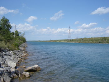
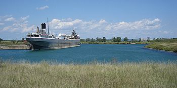
The Welland Canal is a ship canal in Canada that extends from Port Weller, Ontario, on Lake Ontario, to Port Colborne, Ontario, on Lake Erie. As a part of the St...
in Ontario
Ontario
Ontario is a province of Canada, located in east-central Canada. It is Canada's most populous province and second largest in total area. It is home to the nation's most populous city, Toronto, and the nation's capital, Ottawa....
, Canada
Canada
Canada is a North American country consisting of ten provinces and three territories. Located in the northern part of the continent, it extends from the Atlantic Ocean in the east to the Pacific Ocean in the west, and northward into the Arctic Ocean...
.
A new channel 13.4 km (8.3 mi) long was constructed, providing a shorter, more direct alignment between Port Robinson
Port Robinson, Ontario
Port Robinson is a small community in the southernmost part of Thorold, Ontario, Canada. The community is divided in half by the Welland Canal, as there is no bridge in the immediate vicinity to connect the two halves of the community. In the summer, a passenger ferry runs across the canal...
and Port Colborne
Port Colborne, Ontario
Port Colborne is a city on Lake Erie, at the southern end of the Welland Canal, in the Niagara Region of southern Ontario, Canada...
and by-passing downtown Welland
Welland, Ontario
Welland is a city in the Regional Municipality of Niagara in Southern Ontario, Canada.The city has been traditionally known as the place where rails and water meet, referring to the railways from Buffalo to Toronto and Southwestern Ontario, and the waterways of Welland Canal and Welland River,...
. The project helped improve navigation along the canal and alleviated problems the presence of a busy ship canal
Ship canal
A ship canal is a canal especially constructed to carry ocean-going ships, as opposed to barges. Ship canals can be enlarged barge canals, canalized or channelized rivers, or canals especially constructed from the start to accommodate ships....
was causing in Welland.
Background
Although the city of Welland had originally grown around the canal, by the 1960s the constant interruptions in the flow of the vehicular and rail traffic through the city became bothersome. A single ship would hold up traffic for at least ten minutes as it travelled under a vertical lift bridge. In periods of heavy ship traffic, a bridge might stay raised for multiple ships to pass, and long lines of cars, trucks and buses could be delayed more than 30 minutes. Additionally, many railroad yards and lines originally built on Welland's outskirts now found themselves in the middle of a growing city; the heavily used rail lines from TorontoToronto
Toronto is the provincial capital of Ontario and the largest city in Canada. It is located in Southern Ontario on the northwestern shore of Lake Ontario. A relatively modern city, Toronto's history dates back to the late-18th century, when its land was first purchased by the British monarchy from...
to Buffalo
Buffalo, New York
Buffalo is the second most populous city in the state of New York, after New York City. Located in Western New York on the eastern shores of Lake Erie and at the head of the Niagara River across from Fort Erie, Ontario, Buffalo is the seat of Erie County and the principal city of the...
were suffering delays, as well.
The old route, established in 1932 with the building of the fourth Welland Canal, was also inconvenient to the ships since it was twisting and narrow. The five vertical lift bridges and a railroad swing bridge
Swing bridge
A swing bridge is a movable bridge that has as its primary structural support a vertical locating pin and support ring, usually at or near to its centre of gravity, about which the turning span can then pivot horizontally as shown in the animated illustration to the right...
, all within close distance of one another, made the manoeuvring tricky and the journey stressful. Captains complained of bulky buildings on the canal's edge blocking the line of sight. One of them commented, "The main thing every Lakes captain used to dread was Bridge 15 [built during the 3rd canal era, but in use until 1972], a railway bridge in the town of Welland with an abutment in the middle... I think every captain on the Lakes must have [scraped it] at one time or another." http://www.welland.library.on.ca/digital/clipping/source/bypass/11088.jpg
Construction
The by-pass project was a massive undertaking: 16.2 km² (4,000 acreAcre
The acre is a unit of area in a number of different systems, including the imperial and U.S. customary systems. The most commonly used acres today are the international acre and, in the United States, the survey acre. The most common use of the acre is to measure tracts of land.The acre is related...
s) of land was expropriated for the construction. Approximately 50 million cubic metre
Cubic metre
The cubic metre is the SI derived unit of volume. It is the volume of a cube with edges one metre in length. An alternative name, which allowed a different usage with metric prefixes, was the stère...
s of material was excavated. The new channel is 100 m wide (330 ft), as compared to the 58 m (192 ft) width of the old channel. The channel's minimum depth is 9 m (30 ft). Two tunnels, the Main Street Tunnel and the Townline Tunnel
Townline Tunnel
The Townline Tunnel, located in Welland, Ontario, Canada, is an underwater tunnel, carrying Highway 58A as well as the Canadian Pacific Railway under the Welland Canal. The "A" suffix is a misnomer since it is more of a connector than an alternative route. Highway 58A is a two-lane freeway in its...
, were constructed to allow vehicles and trains to pass beneath the canal.
To complement this, an aqueduct
Aqueduct
An aqueduct is a water supply or navigable channel constructed to convey water. In modern engineering, the term is used for any system of pipes, ditches, canals, tunnels, and other structures used for this purpose....
, to convey the Welland River
Welland River
The Welland River is a river in the Niagara Region of southern Ontario which flows from its headwaters south of Hamilton, Ontario to empty into the Niagara River near the city of Niagara Falls, Ontario. It drains an area of 880 km²....
under the new canal alignment, was built. The aqueduct's design is what is known as a four-tube inverted-syphon culvert, 200 m (638 ft) long, 28 m (92 ft) wide, and extending 9 m (30 ft) below the navigation channel. It was constructed from 30,000 cubic metres of concrete. Approximately 1.6 km (0.994196378639691 mi) of new river channel was constructed to route the river into the aqueduct.
Many of the area's rail lines, which had previously been constructed to fit around the existing alignment, had to be dramatically altered for the new alignment. An estimated 161 km (100 mi) of new track was laid at a cost of CAD$
Canadian dollar
The Canadian dollar is the currency of Canada. As of 2007, the Canadian dollar is the 7th most traded currency in the world. It is abbreviated with the dollar sign $, or C$ to distinguish it from other dollar-denominated currencies...
50 million. A Google map is available which shows the changes to the rail network as a result of the canal relocation, as well as changes made since http://maps.google.com/maps/ms?ie=UTF&msa=0&msid=112122431676358120996.0004404f9b3d6957cb2a7. This map also details the old and new routes of the canal.
The construction started with the sinking of the first shovel on June 9, 1967, and continued for six years. (During construction, a giant "Earth mover" working on the canal, accidentally struck and ruptured a buried natural gas line, which erupted into a torch-like flame approx 90–100 meters high; there were no injuries.) In a symbolic event watched by many residents, on a snowy night, Bridge #13 on Welland's East Main Street came up for the last time, lighted by floodlights, on December 15, 1972, the new bypass would be open to shipping for the next season. (The bridge was actually quietly opened the next day to allow the passage of a St. Lawrence Seaway service vessel.)
The Main Street Tunnel was officially opened on May 20, 1972, with the Townline Tunnel following on July 13. Rail traffic through the Townline Tunnel was inaugurated on January 31, 1973. The new canal was first traversed by the Canadian Coast Guard cutter Griffin on March 27, 1973. The first commercial ship to pass through the by-pass was the M.V. Senneville on March 28, 1973. It carried a cargo of 1,063,868 bushels of barley in transit from Duluth, Minnesota
Duluth, Minnesota
Duluth is a port city in the U.S. state of Minnesota and is the county seat of Saint Louis County. The fourth largest city in Minnesota, Duluth had a total population of 86,265 in the 2010 census. Duluth is also the second largest city that is located on Lake Superior after Thunder Bay, Ontario,...
to Port Cartier, Quebec. The official opening ceremony for the Welland By-pass took place on July 14, 1973.
Overall, the project cost approximately CAD$188 million. The new channel reduced the length of the canal by 1.3 km (0.807784557644749 mi) and replaced six bridge crossings with the two new tunnels. It reduced the transit time through the Welland Canal by about 30 minutes (5%) as compared to the old alignment.
Outcomes
The Welland By-pass markedly simplified ship passage along the Welland Canal. The city was no longer dependent on often erratic ship schedules. (For instance, a scheduled city-wide bus service was only instituted after the relocation.)A decision had to be made as to the use of the old alignment. Originally, one of the proposed ideas was for it to be filled in and an extension to Highway 406 be run in it. That never came to be, and instead the old canal was turned over to the city and renamed the Welland Recreational Waterway
Welland Recreational Waterway
The Welland Recreational Waterway is a water channel in the city of Welland, Ontario, Canada. It is an old alignment of the Welland Ship Canal that has been abandoned after the construction of the Welland By-Pass in the 1970s. The Waterway is now managed by the Welland Recreational Canal...
.
Recently, the city has seen the construction of a new Civic Centre, including the city hall
City hall
In local government, a city hall, town hall or a municipal building or civic centre, is the chief administrative building of a city...
and the public library
Public library
A public library is a library that is accessible by the public and is generally funded from public sources and operated by civil servants. There are five fundamental characteristics shared by public libraries...
downtown by the old canal.
Since the opening of the by-pass, Welland's east side has become a virtual island; separated from the rest of the Niagara Peninsula
Niagara Peninsula
The Niagara Peninsula is the portion of Southern Ontario, Canada lying between the south shore of Lake Ontario and the north shore of Lake Erie. It stretches from the Niagara River in the east to Hamilton, Ontario in the west. The population of the peninsula is roughly 1,000,000 people...
by the old canal channel to the west and by the by-pass channel to the east.
External links
- The Welland Public Library's Canal history pages contain many newspaper clippings and photos documenting the Canal's history in general, and the construction of the By-pass in particular.
- Railway Maps, including maps outlining the By-pass project.