
Wayne Gretzky Drive
Encyclopedia

Edmonton
Edmonton is the capital of the Canadian province of Alberta and is the province's second-largest city. Edmonton is located on the North Saskatchewan River and is the centre of the Edmonton Capital Region, which is surrounded by the central region of the province.The city and its census...
, Alberta
Alberta
Alberta is a province of Canada. It had an estimated population of 3.7 million in 2010 making it the most populous of Canada's three prairie provinces...
, Canada
Canada
Canada is a North American country consisting of ten provinces and three territories. Located in the northern part of the continent, it extends from the Atlantic Ocean in the east to the Pacific Ocean in the west, and northward into the Arctic Ocean...
. Originally Capilano Drive, it was officially renamed October 1, 1999 after NHL hockey player Wayne Gretzky
Wayne Gretzky
Wayne Douglas Gretzky, CC is a Canadian former professional ice hockey player and former head coach. Nicknamed "The Great One", he is generally regarded as the best player in the history of the National Hockey League , and has been called "the greatest hockey player ever" by many sportswriters,...
, as a tribute to his years with the Edmonton Oilers
Edmonton Oilers
The Edmonton Oilers are a professional ice hockey team based in Edmonton, Alberta, Canada. They are members of the Northwest Division in the Western Conference of the National Hockey League ....
. The same day, Wayne Gretzky's number 99 jersey was retired, at the then Skyreach Centre
Rexall Place
Rexall Place is an indoor arena in Edmonton, Alberta, Canada situated on the north side of Northlands. It is currently the home to the Edmonton Oilers of the National Hockey League, the Edmonton Rush of the National Lacrosse League and the Edmonton Oil Kings of the WHL...
, which lies just west of Wayne Gretzky Drive, at 118 Avenue.
The freeway portion of Wayne Gretzky Drive was opened in 1969 by widening and connecting the residential streets of 75 Street south of the river, and 72 Street north of the river. It starts as arterial road
Arterial road
An arterial road, or arterial thoroughfare, is a high-capacity urban road. The primary function of an arterial road is to deliver traffic from collector roads to freeways, and between urban centres at the highest level of service possible. As such, many arteries are limited-access roads, or feature...
75 Street, then changes its name and speed limit at 101 Avenue to become a freeway. It crosses the North Saskatchewan River valley
North Saskatchewan River valley parks system
The North Saskatchewan River valley parks system is a continuous collection of urban parks in the North Saskatchewan River valley of Edmonton, Alberta....
, by passing under 106 Avenue and Ada Boulevard. As it approaches Northlands
Northlands
Northlands is a non-profit, volunteer organization in Edmonton, Alberta. It was founded in 1879, before the official incorporation of the city of Edmonton, or the province of Alberta....
and the Alberta Avenue
Alberta Avenue, Edmonton
Alberta Avenue is a pre–World War II neighbourhood in Edmonton, Alberta, Canada.-The Alberta Avenue neighbourhood:Alberta Avenue is one of the older residential neighbourhoods in Edmonton, with much of the area's development occurring during the First World War era...
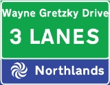
area, it again returns into an arterial, with traffic lights. The exits to Northlands at 112 and 116 Avenues are clearly marked with overhead street signs in blue, and with the Northlands logo. Because of property constraints, to maintain the number of lanes, the freeway is divided into Wayne Gretzky Drive Northbound and Southbound, formally 72 and 73 Streets, at 118 Avenue. 119 Avenue services the north Rexall Place
Rexall Place
Rexall Place is an indoor arena in Edmonton, Alberta, Canada situated on the north side of Northlands. It is currently the home to the Edmonton Oilers of the National Hockey League, the Edmonton Rush of the National Lacrosse League and the Edmonton Oil Kings of the WHL...
parking lot to the west, and is a dead end to the east, because it was blocked off from being used as a shortcut, disrupting traffic flow during major Northlands events. The northbound and southbound then converge again before crossing the LRT
Edmonton Light Rail Transit
Edmonton Light Rail Transit, more commonly referred to as the LRT, is a light rail system in Edmonton, Alberta. Part of the Edmonton Transit System , the 20.5-kilometre route starts in Edmonton's northeast suburbs and ends at Century Park in Edmonton's south end.The ETS designates the LRT as Route...
lines. Fort Road
Fort Road, Edmonton
Fort Road was a major route in connecting Edmonton and Fort Saskatchewan, Alberta, Canada. It was formed on the west side of the CN Rail tracks that still connects the two cities, and crosses the North Saskatchewan River just south of the current Highway 15 bridge...
, which runs to the west, meets up with Wayne Gretzky Drive at an at-grade intersection, then runs concurrently along with it for approximately 180 metres (590.6 ft) to Yellowhead Trail. The single-point urban interchange at Yellowhead Trail, allows the Yellowhead to run as a freeway, and has the benefit of only one traffic light, and U-turns for westbound and eastbound traffic. At this interchange, Wayne Gretzky Drive changes its name to Fort Road.
Because of their short lengths, Wayne Gretzky Drive and Groat Road
Groat Road
Groat Road is a freeway in Edmonton, Alberta, Canada.At a roundabout west of the University of Alberta, Edmonton's river valley road Saskatchewan Drive branches Groat Road to the north and heads down into the river valley. Here Groat Road crosses the North Saskatchewan River on Groat Bridge. It...
will be the only freeways in Edmonton not to have a highway designation, until the completion of Terwillegar Drive
Terwillegar Drive
Terwillegar Drive is a developing freeway in south-west Edmonton, Alberta, Canada. It is currently still under construction, with the majority of its intersection at-grade, it retains its arterial road status...
.
Neighbourhoods
List of neighbourhoods Wayne Gretzky Drive runs through, in order from south to north:- Terrace HeightsTerrace Heights, EdmontonTerrace Heights is a roughly triangle-shaped residential neighbourhood in south east Edmonton, Alberta, Canada.According to the 2001 federal census, most of the development in the neighbourhood occurred in the first fifteen year after World War II. It was during this time that 84% of the...
- Forest HeightsForest Heights, EdmontonForest Heights is a residential neighbourhood in south east Edmonton, Alberta, Canada that overlooks the North Saskatchewan River valley to the north and west...
- Virginia ParkVirginia Park, EdmontonVirginia Park is a neighbourhood in north east Edmonton, Alberta, Canada. It is located between the North Saskatchewan River valley to the south and Northlands Park to the north. Its eastern boundary overlooks Wayne Gretzky Drive...
- BellevueBellevue, EdmontonBellevue is a smaller residential neighbourhood located in north east Edmonton, Alberta, Canada. The neighbourhood overlooks the North Saskatchewan River....
- ParkdaleParkdale, EdmontonParkdale is a central neighbourhood in Edmonton, Alberta, Canada located a short distance north of the downtown core. Located just to the south of the neighbourhood is Commonwealth Stadium and just to the north east is Rexall Place...
- MontroseMontrose, EdmontonMontrose is a residential neighbourhood in north east Edmonton, Alberta, Canada. Edmonton's Rexall Place, home of the Edmonton Oilers and Edmonton Oil Kings hockey teams, is located at the southwest corner of the neighbourhood....
- Elmwood ParkElmwood Park, EdmontonElmwood Park is a neighbourhood in north central Edmonton, Alberta, Canada.Most of the residential construction in the neighbourhood occurred between the end of World War II and 1970. During this time, roughly two out of every three residences were constructed.Just over half the residences in the...
Bridge structures
A pedestrian bridgePedestrian separation structure
A pedestrian separation structure is any structure that removes pedestrians from a vehicle roadway. This creates a road junction where vehicles and pedestrians do not interact.This can be considered a type of grade separation structure on the road....
flysover Wayne Gretzky Drive at approximately 104 Avenue, connecting the neighbourhoods of Forest Heights
Forest Heights, Edmonton
Forest Heights is a residential neighbourhood in south east Edmonton, Alberta, Canada that overlooks the North Saskatchewan River valley to the north and west...
and Terrance Heights
Terrace Heights, Edmonton
Terrace Heights is a roughly triangle-shaped residential neighbourhood in south east Edmonton, Alberta, Canada.According to the 2001 federal census, most of the development in the neighbourhood occurred in the first fifteen year after World War II. It was during this time that 84% of the...
. 53°32′48"N 113°26′32"W
Capilano Bridge
Capilano Bridge (Edmonton)
The Capilano Bridge is a bridge that spans the North Saskatchewan River in Edmonton, Alberta, Canada. It was built in 1969, is named for the nearby Capilano neighbourhood, and is part of Wayne Gretzky Drive.-References:...
takes Wayne Gretzky Drive over the North Saskatchewan River
North Saskatchewan River
The North Saskatchewan River is a glacier-fed river that flows east from the Canadian Rockies to central Saskatchewan. It is one of two major rivers that join to make up the Saskatchewan River....
, spanning 290 metres (951.4 ft). 53°33′20"N 113°26′19"W
Grant Moellmann Bridge, takes Wayne Gretzky Drive over the LRT
Edmonton Light Rail Transit
Edmonton Light Rail Transit, more commonly referred to as the LRT, is a light rail system in Edmonton, Alberta. Part of the Edmonton Transit System , the 20.5-kilometre route starts in Edmonton's northeast suburbs and ends at Century Park in Edmonton's south end.The ETS designates the LRT as Route...
tracks and a CN spur that used to service the surrounding industrial area. It was opened in 1995 bridging the gap between 120 Avenue and Fort Road. It is named after Edmontonian ironworker Grant Moellmann (1935-1994) who fell to his death placing the bridge's last girder on November 24, 1994. A plaque was placed on the bridge in September of 1998 to mark the significance of this naming. 53°34′31"N 113°27′11"W
Interchanges and intersections
Wayne Gretzky Drive currently has five interchanges (bold), giving it freeway status for the 3.4 kilometres (2.1 mi) from 101 Avenue to 116 Avenue, and a maximum speed limit of 80 km/h.| Direction | Intersecting road | Current intersection type | Coordinates |
|---|---|---|---|
| South-North | 101 Avenue Baseline Road (Sherwood Park) Baseline Road/101 Avenue NW is a major arterial road in east Edmonton and north Sherwood Park, Alberta, Canada. It was given this name by Strathcona County because Township Road 530 was used as a baseline for surveying. Edmonton does not follow Strathcona County's naming convention and refers to it... |
At-grade (traffic lights) | 53°32′28"N 113°26′36"W |
| 106 Avenue | Partial diamond interchange | 53°32′58"N 113°26′19"W | |
| Ada Boulevard | Flyover Overpass An overpass is a bridge, road, railway or similar structure that crosses over another road or railway... |
53°33′36"N 113°26′34"W | |
| 112 Avenue | Diamond interchange Diamond interchange A diamond interchange is a common type of road junction, used where a freeway crosses a minor road. The freeway itself is grade-separated from the minor road, one crossing the other over a bridge... |
53°33′46"N 113°26′47"W | |
| 116 Avenue | T Intersection 3-way junction A 3-way junction is a type of road junction with three arms. A Y junction generally has 3 arms of equal size... (traffic lights) |
53°34′5"N 113°27′5"W | |
| 118 Avenue 118 Avenue, Edmonton 118 Avenue is the designated name of two major arterial roads in central Edmonton, Alberta, Canada, separated by the Edmonton City Centre Airport. The west side services both an industrial area, and a residential area, while the east 118 Avenue, originally Alberta Avenue, is one of the oldest... |
Diamond interchange at grade | 53°34′13"N 113°27′10"W | |
| 119 Avenue | Diamond interchange at grade | 53°34′19"N 113°27′10"W | |
| 72 Street / 120 & 121 Avenues | Directional T interchange (northbound only) | 53°34′24"N 113°27′9"W | |
| Mount Lawn Road | T intersection (southbound only) | 53°34′36"N 113°27′14"W | |
| Fort Road Fort Road, Edmonton Fort Road was a major route in connecting Edmonton and Fort Saskatchewan, Alberta, Canada. It was formed on the west side of the CN Rail tracks that still connects the two cities, and crosses the North Saskatchewan River just south of the current Highway 15 bridge... / 124 Avenue |
At-grade (traffic lights) | 53°34′45"N 113°27′16"W | |
| Yellowhead Trail | Single-point urban interchange Single-point urban interchange A single-point urban interchange , also called a single-point interchange or single-point diamond interchange , is a type of highway interchange... |
53°34′50"N 113°27′11"W |