
Washington State Route 291
Encyclopedia
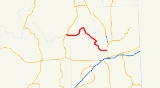
State Route 291 is a 33.09 miles (53.3 km) long state highway
located in Spokane
and Stevens counties in the U.S. state
of Washington. The highway begins at an intersection with concurrent
highways U.S. Route 2
(US 2) and US 395
and travels northwest to an intersection with SR 231
.
. The highway travels west along West Francis Street through western Spokane, before turning northwest along North Nine Mile Road near Balboa. The highway begins to parallel the Spokane River
as it passes a golf course near the community of Nine Mile Falls
. The highway continues northwest, entering Stevens County from Spokane County, just east of the Nine Mile Falls Dam, before climbing and shifting further north of the river to accommodate a housing development on the banks of the river. Entering the community of Tumtum
the highway turns southwest, snaking around Long Lake, formed by the converging of the Spokane River and the Little Spokane River
before turning west and terminating at SR 231.
Every year the Washington State Department of Transportation
(WSDOT) conducts a series of surveys on its highways in the state to measure traffic volume. This is expressed in terms of average annual daily traffic (AADT), which is a measure of traffic volume for any average day of the year. In 2009, WSDOT calculated that as few as 360 cars traveled through the intersection with Corkscrew Canyon Road near the northern terminus, and as many as 30,000 cars passed through the intersection with Ash Street in downtown Spokane.
, the portion of SR 291 between Spokane and the Stevens County line was designated Secondary State Highway 3S.
State highway
State highway, state road or state route can refer to one of three related concepts, two of them related to a state or provincial government in a country that is divided into states or provinces :#A...
located in Spokane
Spokane County, Washington
Spokane County is a county located in the U.S. state of Washington, named after the Spokane tribe. As of the 2010 census the population was 471,221, making it the fourth most populous county in Washington state. The largest city and county seat is Spokane, the second largest city in the state,...
and Stevens counties in the U.S. state
U.S. state
A U.S. state is any one of the 50 federated states of the United States of America that share sovereignty with the federal government. Because of this shared sovereignty, an American is a citizen both of the federal entity and of his or her state of domicile. Four states use the official title of...
of Washington. The highway begins at an intersection with concurrent
Concurrency (road)
A concurrency, overlap, or coincidence in a road network is an instance of one physical road bearing two or more different highway, motorway, or other route numbers...
highways U.S. Route 2
U.S. Route 2 in Washington
U.S. Route 2 is a part of the United States Numbered Highway System that has a western segment that runs from Everett, Washington, to the Upper Peninsula of the US state of Michigan. In Washington, it is a state highway that begins at in Downtown Everett. The of US 2 that lie within...
(US 2) and US 395
U.S. Route 395 in Washington
In the U.S. state of Washington, U.S. Route 395 is a major state highway in two parts, separated by a long overlap with Interstate 90 between Ritzville and Spokane. The southern piece, from I-82 near the Tri-Cities to I-90 near Ritzville, is a high-speed four-lane divided highway...
and travels northwest to an intersection with SR 231
Washington State Route 231
State Route 231 is a long state highway in the U.S. state of Washington serving communities in Lincoln and Stevens counties. The highway, located entirely west of Spokane in the Inland Empire, serves Sprague, Edwall, Reardan, Springdale and Chewelah...
.
Route description
SR 291 begins at an intersection with US 2 / US 395, named North Division Street, and West Francis Street in the Town and Country neighborhood of SpokaneSpokane, Washington
Spokane is a city located in the Northwestern United States in the state of Washington. It is the largest city of Spokane County of which it is also the county seat, and the metropolitan center of the Inland Northwest region...
. The highway travels west along West Francis Street through western Spokane, before turning northwest along North Nine Mile Road near Balboa. The highway begins to parallel the Spokane River
Spokane River
The Spokane River is a tributary of the Columbia River, approximately long, in northern Idaho and eastern Washington in the United States. It drains a low mountainous area east of the Columbia, passing through the city of Spokane, Washington.-Description:...
as it passes a golf course near the community of Nine Mile Falls
Nine Mile Falls, Washington
Nine Mile Falls is an unincorporated community in Spokane County, Washington, United States. It is located 9 mi from downtown Spokane, at the location of the former falls on the Spokane River. The Nine Mile Falls Dam was built by Spokane & Inland Empire Railroad on the site of the falls in...
. The highway continues northwest, entering Stevens County from Spokane County, just east of the Nine Mile Falls Dam, before climbing and shifting further north of the river to accommodate a housing development on the banks of the river. Entering the community of Tumtum
Tumtum, Washington
Tumtum is an unincorporated community in Stevens County, Washington, United States. Tumtum is located along the Spokane River and Washington State Route 291 northwest of Spokane. Tumtum has a post office with ZIP code 99034....
the highway turns southwest, snaking around Long Lake, formed by the converging of the Spokane River and the Little Spokane River
Little Spokane River
The Little Spokane River is a major tributary of the Spokane River, approximately 35 mi long, in eastern Washington in the United States. It drains a rural area of forested foothills and a farming valley north of the city of Spokane along the Idaho-Washington border.It rises in southern Pend...
before turning west and terminating at SR 231.
Every year the Washington State Department of Transportation
Washington State Department of Transportation
The Washington State Department of Transportation , was established in 1905. The agency, led by a Secretary and overseen by the Governor, is a Washington governmental agency that constructs, maintains, and regulates the use of the state's transportation infrastructure...
(WSDOT) conducts a series of surveys on its highways in the state to measure traffic volume. This is expressed in terms of average annual daily traffic (AADT), which is a measure of traffic volume for any average day of the year. In 2009, WSDOT calculated that as few as 360 cars traveled through the intersection with Corkscrew Canyon Road near the northern terminus, and as many as 30,000 cars passed through the intersection with Ash Street in downtown Spokane.
History
Before the 1964 state highway renumbering1964 state highway renumbering (Washington)
In 1963, a law was passed authorizing a new numbering for sign routes. In 1970 the legislative definitions were changed to use the sign route numbers but renamed state routes...
, the portion of SR 291 between Spokane and the Stevens County line was designated Secondary State Highway 3S.