
Washington State Route 224
Encyclopedia
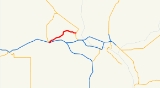
State Route 224 is a 10.15 miles (16.3 km) long state highway
located entirely in Benton County
, Washington, United States. The highway serves to connect SR 225
to Interstate 82
(I-82) and U.S. Route 12
(US 12), and to link Benton City
to West Richland
and Richland
. Before the 1964 state highway renumbering
the highway was numbered Secondary State Highway 3R. SR 224 is a lightly traveled rural highway except through Richland, where an average of 16,000 cars traveled the highway daily in 2009. The Washington State Department of Transportation
(WSDOT) is currently studying plans to alleviate traffic congestion at the western terminus of the highway, with plans ranging from moving the exit ramp from I-82, to creating a roundabout
, to adding a traffic light.
lot on the south side of the highway, the road turns back to the north on Van Giesen Street, paralleling the Yakima River
, slowly turning northeast through a rural area of Benton County. After passing through farmland SR 224 becomes the main east-west thoroughfare of West Richland. Exiting the town, the highway passes over the Yakima River and enters Richland. Before the highway terminates at an intersection with SR 240
southeast of the Richland Airport
, the highway crosses over a single track
belonging to the Tri-City and Olympia Railroad. Van Giesen Street continues east from the terminus of SR 224 for another 1.7 miles (2.7 km), turning south as Hains Avenue at the Columbia River
.
The highway is primarily a two-lane road between Benton City and West Richland. The road expands to four lanes in West Richland, a width the highway remains to its terminus in Richland. Speed limits posted on the highway range from 30 miles per hour (48.3 km/h) to 55 miles per hour (88.5 km/h).
Every year WSDOT conducts a series of surveys on its highways in the state to measure traffic volume. This is expressed in terms of average annual daily traffic (AADT), which is a measure of traffic volume for any average day of the year. In 2009, WSDOT calculated that as few as 3,200 cars traveled through the intersection at Keene Road, west of West Richland, and as many as 16,000 cars at the eastern terminus.
highways U.S. Route 410 and PSH 3. The highway now known as SR 224 was numbered Secondary State Highway 3R (SSH 3R) between 1937 and the 1964 state highway renumbering
, which abolished the Primary and Secondary highway numbers, replacing them with Sign Route numbers, later renamed State Routes.
The twin set of bridges that carry I-82 over the highway at the western terminus were built in 1973, which was during the initial construction of I-82 through southern Washington. The current bridge that carries SR 224 over the Yakima River was constructed in 1993, replacing the original bridge on the highway.
.
{| class="wikitable"
|-
!scope=col|Location
!scope=col|Mile
!scope=col|Destinations
!scope=col|Notes
|-
|rowspan=2|Benton City
|0.00–0.04
|, Pendleton
|Interchange
, western terminus
|-
|0.05–0.06
|
|
|-
|Richland
|10.13–10.15
|
|Eastern terminus
|-
State highway
State highway, state road or state route can refer to one of three related concepts, two of them related to a state or provincial government in a country that is divided into states or provinces :#A...
located entirely in Benton County
Benton County, Washington
Benton County is a county located in the south-central portion of the U.S. state of Washington. The Columbia River makes up the north, south, and east boundaries of the county. In 2010, its population was 175,177. The county seat is Prosser, and its largest city is Kennewick...
, Washington, United States. The highway serves to connect SR 225
Washington State Route 225
State Route 225 is an long two-lane state highway located entirely in Benton County, Washington, United States. The highway travels over the Benton City – Kiona Bridge, which is listed on the Washington Heritage Register and National Register of Historic Places, over the Yakima River...
to Interstate 82
Interstate 82
Interstate 82 is a Interstate Highway that extends from I-90 in Ellensburg, Washington to I-84 near Umatilla, Oregon in the United States. In the state of Washington, it serves the cities of Ellensburg, Yakima, and the Tri Cities , and in Oregon, it serves Umatilla and Hermiston...
(I-82) and U.S. Route 12
U.S. Route 12 in Washington
U.S. Route 12 is a major east-west U.S. Highway, running from Aberdeen, Washington, to Detroit, Michigan. It spans across the state of Washington, and is the only numbered highway to span the entire state from west to east, starting near the Pacific Ocean, and crossing the Idaho state line near...
(US 12), and to link Benton City
Benton City, Washington
Benton City is a city in Benton County, Washington, United States. The population was 3,038 at the 2010 census. The city is strongly associated with nearby Kiona, with which it shares a school district.-History:...
to West Richland
West Richland, Washington
West Richland is a city in Benton County, Washington, United States, served by three elementary schools and a middle school , with an annual budget of about 30 million dollars. The population was 11,811 at the 2010 census...
and Richland
Richland, Washington
Richland is a city in Benton County in the southeastern part of the U.S. state of Washington, at the confluence of the Yakima and the Columbia Rivers. As of the 2010 census, the city population was 48,058. April 1, 2011 estimates from the Washington State Office of Financial Management put the...
. Before the 1964 state highway renumbering
1964 state highway renumbering (Washington)
In 1963, a law was passed authorizing a new numbering for sign routes. In 1970 the legislative definitions were changed to use the sign route numbers but renamed state routes...
the highway was numbered Secondary State Highway 3R. SR 224 is a lightly traveled rural highway except through Richland, where an average of 16,000 cars traveled the highway daily in 2009. The Washington State Department of Transportation
Washington State Department of Transportation
The Washington State Department of Transportation , was established in 1905. The agency, led by a Secretary and overseen by the Governor, is a Washington governmental agency that constructs, maintains, and regulates the use of the state's transportation infrastructure...
(WSDOT) is currently studying plans to alleviate traffic congestion at the western terminus of the highway, with plans ranging from moving the exit ramp from I-82, to creating a roundabout
Roundabout
A roundabout is the name for a road junction in which traffic moves in one direction around a central island. The word dates from the early 20th century. Roundabouts are common in many countries around the world...
, to adding a traffic light.
Route description
SR 224 begins at an interchange with I-82 in southern Benton City. After only 0.05 mi (80.5 m), SR 224 intersects SR 225 and turns east along Kennedy Road. After passing a park and ridePark and ride
Park and ride facilities are car parks with connections to public transport that allow commuters and other people wishing to travel into city centres to leave their vehicles and transfer to a bus, rail system , or carpool for the rest of their trip...
lot on the south side of the highway, the road turns back to the north on Van Giesen Street, paralleling the Yakima River
Yakima River
The Yakima River is a tributary of the Columbia River in south central and eastern Washington State, named for the indigenous Yakama people. The length of the river from headwaters to mouth is , with an average drop of .-Course:...
, slowly turning northeast through a rural area of Benton County. After passing through farmland SR 224 becomes the main east-west thoroughfare of West Richland. Exiting the town, the highway passes over the Yakima River and enters Richland. Before the highway terminates at an intersection with SR 240
Washington State Route 240
State Route 240 is a busy state highway servicing the Tri-Cities of Washington and the Hanford Site.-Route description:Its eastern end begins at the southern end of the Blue Bridge in central Kennewick as an offshoot of U.S. Route 395...
southeast of the Richland Airport
Richland Airport (Washington)
Richland Airport is a public airport located two miles northwest of the central business district of Richland, a city in Benton County, Washington, United States...
, the highway crosses over a single track
Single track (rail)
A single track railway is where trains in both directions share the same track. Single track is normally used on lesser used rail lines, often branch lines, where the traffic density is not high enough to justify the cost of building double tracks....
belonging to the Tri-City and Olympia Railroad. Van Giesen Street continues east from the terminus of SR 224 for another 1.7 miles (2.7 km), turning south as Hains Avenue at the Columbia River
Columbia River
The Columbia River is the largest river in the Pacific Northwest region of North America. The river rises in the Rocky Mountains of British Columbia, Canada, flows northwest and then south into the U.S. state of Washington, then turns west to form most of the border between Washington and the state...
.
The highway is primarily a two-lane road between Benton City and West Richland. The road expands to four lanes in West Richland, a width the highway remains to its terminus in Richland. Speed limits posted on the highway range from 30 miles per hour (48.3 km/h) to 55 miles per hour (88.5 km/h).
Every year WSDOT conducts a series of surveys on its highways in the state to measure traffic volume. This is expressed in terms of average annual daily traffic (AADT), which is a measure of traffic volume for any average day of the year. In 2009, WSDOT calculated that as few as 3,200 cars traveled through the intersection at Keene Road, west of West Richland, and as many as 16,000 cars at the eastern terminus.
History
A roadway has connected Benton City to Richland since at least 1926, while a road with an alignment more similar to that of the current highway first appeared on maps in 1939, with termini at the concurrentConcurrency (road)
A concurrency, overlap, or coincidence in a road network is an instance of one physical road bearing two or more different highway, motorway, or other route numbers...
highways U.S. Route 410 and PSH 3. The highway now known as SR 224 was numbered Secondary State Highway 3R (SSH 3R) between 1937 and the 1964 state highway renumbering
1964 state highway renumbering (Washington)
In 1963, a law was passed authorizing a new numbering for sign routes. In 1970 the legislative definitions were changed to use the sign route numbers but renamed state routes...
, which abolished the Primary and Secondary highway numbers, replacing them with Sign Route numbers, later renamed State Routes.
The twin set of bridges that carry I-82 over the highway at the western terminus were built in 1973, which was during the initial construction of I-82 through southern Washington. The current bridge that carries SR 224 over the Yakima River was constructed in 1993, replacing the original bridge on the highway.
Future
WSDOT is studying several different proposed changes to the SR 224 / SR 225 intersection to improve traffic flow. Several proposals have been introduced to alleviate the situation, including replacing the stop sign at the intersection with a traffic light, reconfiguring the intersection and the off ramp from I-82, and implementing several options featuring roundabouts. WSDOT favors the roundabout options and estimates costs will range between $2 and $7.4 million to construct.Major intersections
The entire route is located within Benton CountyBenton County, Washington
Benton County is a county located in the south-central portion of the U.S. state of Washington. The Columbia River makes up the north, south, and east boundaries of the county. In 2010, its population was 175,177. The county seat is Prosser, and its largest city is Kennewick...
.
{| class="wikitable"
|-
!scope=col|Location
!scope=col|Mile
!scope=col|Destinations
!scope=col|Notes
|-
|rowspan=2|Benton City
Benton City, Washington
Benton City is a city in Benton County, Washington, United States. The population was 3,038 at the 2010 census. The city is strongly associated with nearby Kiona, with which it shares a school district.-History:...
|0.00–0.04
|, Pendleton
Pendleton, Oregon
Pendleton is a city in Umatilla County, Oregon, United States. Pendleton was named in 1868 by the county commissioners for George H. Pendleton, Democratic candidate for Vice-President in the 1864 presidential campaign. The population was 16,612 at the 2010 census...
|Interchange
Interchange (road)
In the field of road transport, an interchange is a road junction that typically uses grade separation, and one or more ramps, to permit traffic on at least one highway to pass through the junction without directly crossing any other traffic stream. It differs from a standard intersection, at which...
, western terminus
|-
|0.05–0.06
|
|
|-
|Richland
Richland, Washington
Richland is a city in Benton County in the southeastern part of the U.S. state of Washington, at the confluence of the Yakima and the Columbia Rivers. As of the 2010 census, the city population was 48,058. April 1, 2011 estimates from the Washington State Office of Financial Management put the...
|10.13–10.15
|
|Eastern terminus
|-