
Washington State Route 127
Encyclopedia
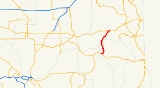
State Route 127 is a state highway
in the U.S. state
of Washington, running from U.S. Route 12
near Pomeroy north to a junction with State Route 26
near Lacrosse.
and Pomeroy
, paralleling US 12 for a short period before turning northeast through some hills before passing over a small creek and leveling off. The highway turns north, passing through lightly populated rural Eastern Washington
. Just after passing the Garfield–Whitman county line, the highway crosses over the Snake River
and passes just east of the Central Ferry State Park. Continuing north, the highway climbs more, turning east briefly after intersecting Big Alkai Road. The highway terminates at an interchange with SR 26 in Dusty
.
Every year the Washington State Department of Transportation
(WSDOT) conducts a series of surveys on its highways in the state to measure traffic volume. This is expressed in terms of average annual daily traffic (AADT), which is a measure of traffic volume for any average day of the year. In 2009, WSDOT calculated that 560 cars use the highway at its southern terminus, and 970 use the highway at its northern terminus. The entire highway is listed on both the WSDOT List of Highways of Statewide Significance, which marks this portion of the highway as a critical to connecting major communities in the state, and the National Highway System
, a system of roads that are important to the nation's economy, defense and mobility.
in Colfax
. While US 295 was a branch of US 95, it never connected to US 95. US 195 connected US 295 with its parent route. U.S. Route 395
also relies on US 195 for its only connection to its parent route.
State highway
State highway, state road or state route can refer to one of three related concepts, two of them related to a state or provincial government in a country that is divided into states or provinces :#A...
in the U.S. state
U.S. state
A U.S. state is any one of the 50 federated states of the United States of America that share sovereignty with the federal government. Because of this shared sovereignty, an American is a citizen both of the federal entity and of his or her state of domicile. Four states use the official title of...
of Washington, running from U.S. Route 12
U.S. Route 12 in Washington
U.S. Route 12 is a major east-west U.S. Highway, running from Aberdeen, Washington, to Detroit, Michigan. It spans across the state of Washington, and is the only numbered highway to span the entire state from west to east, starting near the Pacific Ocean, and crossing the Idaho state line near...
near Pomeroy north to a junction with State Route 26
Washington State Route 26
State Route 26 is a state highway in the Grant, Adams, and Whitman counties, in the U.S. state of Washington. It extends from Interstate 90 east of the community of Vantage, east to U.S. Route 195 in Colfax. SR 26 intersects SR 24, SR 17, US 395, and SR 261 before...
near Lacrosse.
Route description
SR 127 begins at an interchange with US 12, between StarbuckStarbuck, Washington
Starbuck is a town in Columbia County, Washington, United States. The population was 129 at the 2010 census.-History:Named for railroad official W. H. Starbuck, the town was originally a junction on the main line of the Oregon Railroad and Navigation Company. The town was platted in 1894, and...
and Pomeroy
Pomeroy, Washington
Pomeroy is a city in Garfield County, Washington, United States. The population was 1,425 at the 2010 census. It is the county seat of Garfield County.-Geography: Pomeroy is located at ....
, paralleling US 12 for a short period before turning northeast through some hills before passing over a small creek and leveling off. The highway turns north, passing through lightly populated rural Eastern Washington
Eastern Washington
Eastern Washington is the portion of the U.S. state of Washington east of the Cascade Range. The region contains the city of Spokane , the Tri-Cities, the Columbia River and the Grand Coulee Dam, the Hanford Nuclear Reservation and the fertile farmlands of the Yakima Valley and the...
. Just after passing the Garfield–Whitman county line, the highway crosses over the Snake River
Snake River
The Snake is a major river of the greater Pacific Northwest in the United States. At long, it is the largest tributary of the Columbia River, the largest North American river that empties into the Pacific Ocean...
and passes just east of the Central Ferry State Park. Continuing north, the highway climbs more, turning east briefly after intersecting Big Alkai Road. The highway terminates at an interchange with SR 26 in Dusty
Dusty, Washington
Dusty is an unincorporated community in Whitman County, Washington, United States. It lies on Secondary State Highway 11A.-Geography:The community is located in the Palouse Region, which is known for its rolling hills and agricultural production...
.
Every year the Washington State Department of Transportation
Washington State Department of Transportation
The Washington State Department of Transportation , was established in 1905. The agency, led by a Secretary and overseen by the Governor, is a Washington governmental agency that constructs, maintains, and regulates the use of the state's transportation infrastructure...
(WSDOT) conducts a series of surveys on its highways in the state to measure traffic volume. This is expressed in terms of average annual daily traffic (AADT), which is a measure of traffic volume for any average day of the year. In 2009, WSDOT calculated that 560 cars use the highway at its southern terminus, and 970 use the highway at its northern terminus. The entire highway is listed on both the WSDOT List of Highways of Statewide Significance, which marks this portion of the highway as a critical to connecting major communities in the state, and the National Highway System
National Highway System (United States)
The National Highway System is a network of strategic highways within the United States, including the Interstate Highway System and other roads serving major airports, ports, rail or truck terminals, railway stations, pipeline terminals and other strategic transport facilities.Individual states...
, a system of roads that are important to the nation's economy, defense and mobility.
History
SR 127 was part of U.S. Route 295, which was a branch of U.S. Route 95 from 1926 to 1968. US 295 started at U.S. Route 410 (now US 12) near Pomeroy. US 295 went north to the junction of SR 127 and SR 26; then, US 295 went east on SR 26 and ended at U.S. Route 195U.S. Route 195
U.S. Route 195 is a north–south U.S. Route serving the southeastern area of Washington. One of the oldest designations in the U.S. Highway system, it was created in the original 1926 plan. The highway passes two major universities, Washington State University in Pullman, and the University...
in Colfax
Colfax, Washington
Colfax is the county seat of Whitman County, Washington, United States.The population was 2,805 at the 2010 census.It is situated amidst wheat-covered hills in a valley at the confluence of the north and south forks of the Palouse River. U.S...
. While US 295 was a branch of US 95, it never connected to US 95. US 195 connected US 295 with its parent route. U.S. Route 395
U.S. Route 395
U.S. Route 395 is a U.S. Route in the western United States. The southern terminus of the route is in the Mojave Desert at Interstate 15 near Hesperia. The northern terminus is at the Canadian border near Laurier, where the road becomes Highway 395 upon entering British Columbia. At one time, the...
also relies on US 195 for its only connection to its parent route.
Major intersections
| County | Location | Mile | Destinations | Notes |
|---|---|---|---|---|
| Garfield | 0.00 | Southern terminus | ||
| Whitman Whitman County, Washington Whitman County is a county located in the U.S. state of Washington. As of the 2010 census, the population was 44,776, with the majority living in its largest city, Pullman, home to Washington State University, the state's land-grant university. The county seat is at Colfax.Whitman County was... |
27.05 | , Spokane Spokane, Washington Spokane is a city located in the Northwestern United States in the state of Washington. It is the largest city of Spokane County of which it is also the county seat, and the metropolitan center of the Inland Northwest region... |
Northern terminus |