
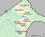
Waramanga, Australian Capital Territory
Encyclopedia
Waramanga is a suburb of Canberra
, Australian Capital Territory
, Australia
located in the district of Weston Creek.
Waramanga was established in the late 1960s and was named after the Aboriginal tribe of Central Australia, also known as the Warumungu people.
, Yamba in the suburb of Phillip
and Iloura, Melrose and Yarra Glen in the suburb of Curtin
(Douglas, 1996).
In June 1968 the suburb of Waramanga was officially gazetted (ACTPLA, 2003).
The bushfire which engulfed parts of Canberra
on January 18, 2003 flowed out of Mount Taylor Nature Reserve and reached the eastern boundary of the suburb at Badimara Street where it was slowed by residents and stopped by a contrary wind. For more information about the bushfire see Canberra bushfires of 2003.
1000 a week, compared to a Canberra wide figure of 29% and an Australia wide figure of 18.6%.
The population of Waramanga is predominantly Australian-born, 73.3% of people being born in Australia. With 6.7% of the population, the second most common birth place is the United Kingdom
. Accommodation is mostly separate houses (80.0%), with semi detached, row or terrace houses and townhouses comprising 16.2% (ABS, 2002).
The population of Waramanga is expected to decline by 7.7% to 2,400 over the 10 years to 2014 compared to a decline of 5.3% for the Weston Creek-Stromlo district (Chief Minister’s Department, 2004).
electorate
of Canberra
. Covering the southside of Canberra and southern ACT, the electorate of Canberra is currently represented by Annette Ellis
of the Australian Labor Party
. The two federal electorates in the ACT are safe or fairly safe ALP seats (AEC, 2005).
Waramanga is located in the ACT Legislative Assembly
electorate of Molonglo. Covering central Canberra, the electorate of Molonglo is currently represented by three Australian Labor Party members, three Liberal Party members and one ACT Greens
member (ACTEC, 2005).
Links to Waramanga polling place results for the 2004 Federal Election and 2004 ACT Legislative Assembly election are listed in the External Links section below.
with spherulitic texture fill up Warramanga from beneath.
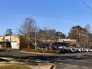
 Waramanga has a busy local shopping centre located on the corner of Damala Street and Waramanga Place. The centre contains a supermarket
, bakery
, Malaysian restaurant, hairdresser
, beauty salon, chemist
, newsagency, medical centre, postal agency and electric mobility scooter sales.
Educational institutions located in Waramanga are:
(a) Government schools -
(b) Non-government schools and colleges -
Churches located in Waramanga are:
Health facilities located in Waramanga are:
Public Transport located in Waramanga are:
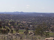
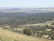
Waramanga has extensive open spaces with playing fields on the western side of the suburb, several neighbourhood parks and pedestrian parkland along the ridge in the centre of the suburb. Waramanga is adjacent to Mount Taylor Nature Reserve, part of Canberra Nature Park
with grassland and hillside walking tracks and sweeping views across Woden and Tuggeranong
Valleys.
Canberra
Canberra is the capital city of Australia. With a population of over 345,000, it is Australia's largest inland city and the eighth-largest city overall. The city is located at the northern end of the Australian Capital Territory , south-west of Sydney, and north-east of Melbourne...
, Australian Capital Territory
Australian Capital Territory
The Australian Capital Territory, often abbreviated ACT, is the capital territory of the Commonwealth of Australia and is the smallest self-governing internal territory...
, Australia
Australia
Australia , officially the Commonwealth of Australia, is a country in the Southern Hemisphere comprising the mainland of the Australian continent, the island of Tasmania, and numerous smaller islands in the Indian and Pacific Oceans. It is the world's sixth-largest country by total area...
located in the district of Weston Creek.
Waramanga was established in the late 1960s and was named after the Aboriginal tribe of Central Australia, also known as the Warumungu people.
History
The Weston Creek district was part of Yarralumla Station, a 40,000 acre (162 km²) property dating back to 1828. It was resumed by the Commonwealth in 1913 from Frederick Campbell who bought the property in 1881. In 1920 9,000 acres (36 km²) of the Woden Valley, including the Weston Creek district, were subdivided for soldier settlement leases. A 1950's map of the district shows four paddocks, Weston paddock, Track paddock, Brown Hill paddock and Oakey Hill paddock intersecting the area which is now the suburb of Waramanga. Long Gully Road ran through the suburb and the nearest homestead was Cooleman on the Kambah Road just west of the present suburb of Fisher. Cooleman was farmed by the Champion family from about 1932. It was previously known as Allawah and was leased to the Anderson family in 1920. Other properties in the district were Avondale and Weston whose homesteads were in the present suburb of HolderHolder, Australian Capital Territory
The suburb of Holder is a part of the Weston Creek District of Canberra, Australian Capital Territory, Australia, and is located 13 km to the southwest of the Canberra city centre...
, Yamba in the suburb of Phillip
Phillip, Australian Capital Territory
Phillip is a suburb of Canberra, Australia in the district of Woden Valley. It is located in the centre of the district and contains the district's main commercial centre, Woden Town Centre. The suburb is named after Arthur Phillip, the first Governor of New South Wales. The suburb name was...
and Iloura, Melrose and Yarra Glen in the suburb of Curtin
Curtin, Australian Capital Territory
Curtin is a suburb in the Canberra, Australia district of Woden. The postcode is 2605.It is next to the suburbs of Yarralumla, Deakin, Hughes, Lyons and Weston...
(Douglas, 1996).
In June 1968 the suburb of Waramanga was officially gazetted (ACTPLA, 2003).
The bushfire which engulfed parts of Canberra
Canberra
Canberra is the capital city of Australia. With a population of over 345,000, it is Australia's largest inland city and the eighth-largest city overall. The city is located at the northern end of the Australian Capital Territory , south-west of Sydney, and north-east of Melbourne...
on January 18, 2003 flowed out of Mount Taylor Nature Reserve and reached the eastern boundary of the suburb at Badimara Street where it was slowed by residents and stopped by a contrary wind. For more information about the bushfire see Canberra bushfires of 2003.
Demographics
On Census night 2006, Waramanga had a population of 2,535 people. Waramanga residents had a median age of 36 compared to a Canberra median of 34. 27.7% of the population earned over A$Australian dollar
The Australian dollar is the currency of the Commonwealth of Australia, including Christmas Island, Cocos Islands, and Norfolk Island, as well as the independent Pacific Island states of Kiribati, Nauru and Tuvalu...
1000 a week, compared to a Canberra wide figure of 29% and an Australia wide figure of 18.6%.
The population of Waramanga is predominantly Australian-born, 73.3% of people being born in Australia. With 6.7% of the population, the second most common birth place is the United Kingdom
United Kingdom
The United Kingdom of Great Britain and Northern IrelandIn the United Kingdom and Dependencies, other languages have been officially recognised as legitimate autochthonous languages under the European Charter for Regional or Minority Languages...
. Accommodation is mostly separate houses (80.0%), with semi detached, row or terrace houses and townhouses comprising 16.2% (ABS, 2002).
The population of Waramanga is expected to decline by 7.7% to 2,400 over the 10 years to 2014 compared to a decline of 5.3% for the Weston Creek-Stromlo district (Chief Minister’s Department, 2004).
Politics
Waramanga is located in the federal House of RepresentativesAustralian House of Representatives
The House of Representatives is one of the two houses of the Parliament of Australia; it is the lower house; the upper house is the Senate. Members of Parliament serve for terms of approximately three years....
electorate
Electoral district
An electoral district is a distinct territorial subdivision for holding a separate election for one or more seats in a legislative body...
of Canberra
Division of Canberra
The Division of Canberra is an Australian Electoral Division in the Australian Capital Territory. The division was created in 1974 from the southern half of the old Division of Australian Capital Territory...
. Covering the southside of Canberra and southern ACT, the electorate of Canberra is currently represented by Annette Ellis
Annette Ellis
Annette Louise Ellis , Australian politician, was a Labor Party member of the Australian House of Representatives from March 1996 to August 2010, representing the Division of Namadgi 1996–98 and the Division of Canberra from 1998 to 2010.In the 1996 federal election she contested Namadgi against...
of the Australian Labor Party
Australian Labor Party
The Australian Labor Party is an Australian political party. It has been the governing party of the Commonwealth of Australia since the 2007 federal election. Julia Gillard is the party's federal parliamentary leader and Prime Minister of Australia...
. The two federal electorates in the ACT are safe or fairly safe ALP seats (AEC, 2005).
Waramanga is located in the ACT Legislative Assembly
Australian Capital Territory Legislative Assembly
The Australian Capital Territory Legislative Assembly is the unicameral legislature of the Australian Capital Territory...
electorate of Molonglo. Covering central Canberra, the electorate of Molonglo is currently represented by three Australian Labor Party members, three Liberal Party members and one ACT Greens
ACT Greens
The ACT Greens is a green political party located in the Australian Capital Territory, and a member of the federation of the Australian Greens....
member (ACTEC, 2005).
Links to Waramanga polling place results for the 2004 Federal Election and 2004 ACT Legislative Assembly election are listed in the External Links section below.
Geology
Deakin Volcanics green grey, red, and purple rhyodaciteRhyodacite
Rhyodacite is an extrusive volcanic rock intermediate in composition between dacite and rhyolite. It is the extrusive equivalent of granodiorite. Phenocrysts of sodium rich plagioclase, sanidine, quartz, and biotite or hornblende are typically set in an aphanitic to glassy light to intermediate...
with spherulitic texture fill up Warramanga from beneath.
Suburb amenities
Supermarket
A supermarket, a form of grocery store, is a self-service store offering a wide variety of food and household merchandise, organized into departments...
, bakery
Bakery
A bakery is an establishment which produces and sells flour-based food baked in an oven such as bread, cakes, pastries and pies. Some retail bakeries are also cafés, serving coffee and tea to customers who wish to consume the baked goods on the premises.-See also:*Baker*Cake...
, Malaysian restaurant, hairdresser
Hairdresser
Hairdresser is a term referring to anyone whose occupation is to cut or style hair in order to change or maintain a person's image. This is achieved using a combination of hair coloring, haircutting, and hair texturing techniques...
, beauty salon, chemist
Chemist
A chemist is a scientist trained in the study of chemistry. Chemists study the composition of matter and its properties such as density and acidity. Chemists carefully describe the properties they study in terms of quantities, with detail on the level of molecules and their component atoms...
, newsagency, medical centre, postal agency and electric mobility scooter sales.
Educational institutions located in Waramanga are:
(a) Government schools -
- Waramanga Preschool located in Nemarang Circuit.
- Arawang Primary located in Nemarang Circuit.
- Stromlo High on the corner of Badimara Street and Namatjira Drive.
(b) Non-government schools and colleges -
- St John Vianney Primary located in Namatjira Drive.
- Alliance College of AustraliaAlliance College of AustraliaAlliance College of Australia, formerly known as Canberra College of Theology, is a bible college in Canberra, Australia.-External links:*...
located in Namatjira Drive.
Churches located in Waramanga are:
- St John Vianney Parish Centre of the Catholic Church in Australia located in Namatjira Drive.
- Woden Valley Alliance Church of the Christian and Missionary Alliance located in Namatjira Drive.
- Canberra Korean Manse of the Uniting Church of Australia located in Badimara Street.
Health facilities located in Waramanga are:
- Weston Creek Veterinary Hospital located in Badimara Street.
- Waramanga Medical Centre located in the shopping centre on the corner of Damala Street and Waramanga Place.
Public Transport located in Waramanga are:
- ACTION Buses run regular services to Waramanga, usually every hour, or every half hour in peak periods. Route 27 services most of Waramanga, on its way between the nearest major bus interchange at Woden Town CentreWoden Town CentreWoden Town Centre is the main commercial centre of the district of Woden Valley in Canberra, Australia. It is located in the Canberra suburb of Phillip....
and the Weston Creek Centre. Route 927 provides an evening service but a seat must be booked. Route 227 provides a more direct service to Civic during rush hours. - No other public transportation is available, apart from taxiTaxicabA taxicab, also taxi or cab, is a type of vehicle for hire with a driver, used by a single passenger or small group of passengers, often for a non-shared ride. A taxicab conveys passengers between locations of their choice...
s.
Waramanga has extensive open spaces with playing fields on the western side of the suburb, several neighbourhood parks and pedestrian parkland along the ridge in the centre of the suburb. Waramanga is adjacent to Mount Taylor Nature Reserve, part of Canberra Nature Park
Canberra Nature Park
The Canberra Nature Park is actually 30 separate protected areas in Canberra, Australian Capital Territory, ranging from bushland hills to lowland native grassland...
with grassland and hillside walking tracks and sweeping views across Woden and Tuggeranong
Tuggeranong
Tuggeranong is the southernmost town centre of Canberra, the capital city of Australia. It comprises 19 suburbs with a total of 31,819 dwellings, housing 87,119 people of the 324,034 people in the Australian Capital Territory . The district occupies 117 square kilometres to the east of the...
Valleys.