

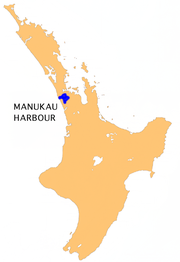
Manukau Harbour
Encyclopedia

New Zealand
New Zealand is an island country in the south-western Pacific Ocean comprising two main landmasses and numerous smaller islands. The country is situated some east of Australia across the Tasman Sea, and roughly south of the Pacific island nations of New Caledonia, Fiji, and Tonga...
by area. It is located to the southwest of the Auckland
Auckland
The Auckland metropolitan area , in the North Island of New Zealand, is the largest and most populous urban area in the country with residents, percent of the country's population. Auckland also has the largest Polynesian population of any city in the world...
isthmus, and is an arm of the Tasman Sea
Tasman Sea
The Tasman Sea is the large body of water between Australia and New Zealand, approximately across. It extends 2,800 km from north to south. It is a south-western segment of the South Pacific Ocean. The sea was named after the Dutch explorer Abel Janszoon Tasman, the first recorded European...
.
Geography
The harbour mouth is between the northern head ("Burnett Head" / "Ohaka Head") located at the southern end of the Waitakere RangesWaitakere Ranges
The Waitakere Ranges are a chain of hills in the Auckland metropolitan area, generally running approximately 25 km from north to south, 25 km west of central Auckland, New Zealand. The maximum elevation within the ranges is 474 m...
and South Head at the end of the long Awhitu Peninsula reaching up from close to the mouth of the Waikato River
Waikato River
The Waikato River is the longest river in New Zealand. In the North Island, it runs for 425 kilometres from the eastern slopes of Mount Ruapehu, joining the Tongariro River system and emptying into Lake Taupo, New Zealand's largest lake. It drains Taupo at the lake's northeastern edge, creates the...
. The mouth is only 1800 metres wide, but after a nine kilometre channel it opens up into a roughly square basin 20 kilometres in width. The harbour has a water surface area of 394 square kilometres. There is a tidal variation of up to 4 metres, a very substantial change, especially since the harbour, being silted up with almost 10 million years of sedimentation, is rather shallow itself.
Because of the large harbour area and narrow mouth between the Manukau Heads
Manukau Heads
The Manukau Heads is the name given to the two promontories that form the entrance to the Manukau Harbour - one of the two harbours of Auckland in New Zealand. The southern head is simply termed "The South Head", whereas the northern head is named "Burnett Head"...
, tidal flow is rapid and a bar at the mouth makes navigating in or out of the harbour dangerous. New Zealand's most tragic shipwreck occurred on the bar in 1863 when HMS Orpheus
HMS Orpheus (1861)
HMS Orpheus was a Jason-class Royal Navy corvette that served as the flagship of the Australian squadron. Orpheus sank off the west coast of Auckland, New Zealand on 7 February 1863: 189 crew out of the ship's complement of 259 died in the disaster, making it the worst maritime tragedy to occur in...
ran aground in clear weather with a loss of 189 lives. For this reason, along with the harbour's shallowness, it is not Auckland's favoured port, and the facilities at Onehunga
Onehunga
Onehunga is a suburb of Auckland City, New Zealand and the location of the Port of Onehunga, the city's small port on the Manukau Harbour. It is eight kilometres south of the city centre, close to the volcanic cone of One Tree Hill, Maungakiekie....
are not very large compared to the other Ports of Auckland
Ports of Auckland
Ports of Auckland Limited , the successor to the Auckland Harbour Board, is the company administering Auckland's commercial freight and cruise ship harbour facilities...
facilities on the Waitemata Harbour
Waitemata Harbour
The quite famous Waitemata Harbour is the main access by sea to Auckland, New Zealand. For this reason it is often referred to as Auckland Harbour, despite the fact that it is only one of two harbours surrounding the city, and is crossed by the Auckland Harbour Bridge. The Waitemata forms the north...
on the northeast of the isthmus.
The harbour has three main arms. The Mangere Inlet
Mangere Inlet
Mangere Inlet is an arm of the Manukau Harbour, the southwestern of the two harbours of Auckland, New Zealand and itself an arm of the Tasman Sea. The inlet lies between the two cities of Auckland City and Manukau City and has a size of 6.6 km2 and a catchment of 34.5 km2, being considered to...
at the northeast lies close to Auckland's central city area, with the inner suburbs of Onehunga
Onehunga
Onehunga is a suburb of Auckland City, New Zealand and the location of the Port of Onehunga, the city's small port on the Manukau Harbour. It is eight kilometres south of the city centre, close to the volcanic cone of One Tree Hill, Maungakiekie....
and Te Papapa
Te Papapa
- to the north-east - to the east - to the south - to the south-west - to the west - to the north-west Penrose Mount Wellington Southdown Favona Mangere Bridge Onehunga...
situated close to its northern shore. The Otahuhu and Mangere
Mangere
Māngere is one of the larger suburbs in South Auckland, in northern New Zealand.The suburb is located on flat land at the northeastern shore of the Manukau Harbour, to the northwest of the centre of Manukau city and 15 kilometres south of Auckland city centre...
urban areas lie south of this arm, which is crossed by the Mangere Bridge
Mangere Bridge
Mangere Bridge, officially also called the Manukau Harbour Crossing, is a motorway bridge over the Manukau Harbour in south-western Auckland, New Zealand, crossing between the suburb also known as Mangere Bridge and the suburb of Onehunga...
. In the southeast is the Papakura Channel, which extends into the urban area of Papakura
Papakura
The Papakura District was the name of a local council territory in New Zealand's Auckland Region that existed from 1989 until 2010. The area made up the southernmost part of the Auckland metropolitan area....
. In the southwest a further inlet known as the Waiuku River
Waiuku River
The Waiuku River is located to the southwest of the city of Auckland in New Zealand. Despite its name, the "river" is in fact an estuarial arm of the Manukau Harbour. It joins the harbour at the south west and extends south for 12 kilometres, having its head close to the town of Waiuku....
reaches south to the town of Waiuku
Waiuku
Waiuku is a country town in the Franklin District, in the North Island of New Zealand. It is located at the southern end of the Waiuku River, which is an estuarial arm of the Manukau Harbour...
. Auckland Airport is located close to the harbour's eastern shore.
History
The harbour was an important historical waterway for the Māori. It had several portagePortage
Portage or portaging refers to the practice of carrying watercraft or cargo over land to avoid river obstacles, or between two bodies of water. A place where this carrying occurs is also called a portage; a person doing the carrying is called a porter.The English word portage is derived from the...
s to the Pacific Ocean and to the Waikato River, and various villages and pā
Pa (Maori)
The word pā can refer to any Māori village or settlement, but in traditional use it referred to hillforts fortified with palisades and defensive terraces and also to fortified villages. They first came into being about 1450. They are located mainly in the North Island north of lake Taupo...
(hill forts) clustered around it. Snapper, flounder, mullet, scallops, cockles and pipi
Paphies australis
Paphies australis or pipi is a bivalve mollusc of the family Mesodesmatidae, endemic to New Zealand.The pipi is a shellfish with a solid white, elongated symmetrical shell with the apex at the middle. It is covered by a thin yellow periostracum...
provided food in plentiful amounts.
Cornwallis, beside the Puponga Peninsula, was the first site for the future city of Auckland. However because of fraudulent land sales and rugged conditions, the settlement was abandoned in the 1840s. The surrounding bush clad hills had vast amounts of kauri removed for milling and shipped from a wharf on Paratutai to either the other end of the harbour at Onehunga for use in house building in the new city of Auckland, or along the coast to other New Zealand settlements. The last mills were abandoned in the early 1920s.
European settlement of the area was thus almost often an outgrowth of the Waitemata Harbour-centred settlement, as these settlers spread south and west through the isthmus and reached the Manukau Harbour. One of the few separate earlier European settlements was Onehunga, from where some raiding of enemy settlements occurred during the New Zealand wars, and which later became a landing point for kauri and other products landed by ship and canoe from the south, the shipping route being shorter than the one along the east coast to the Waitemata Harbour. However, the combination of the difficult entry into the harbour, which limited ships to about 1,000 tons maximum, and the extension of the railway to Onehunga in 1873 made naval traffic on the harbour less important again, though the Port of Onehunga can trace its origins to this time.
Construction of a canal between the Manukau and the Waitemata was considered in the early 1900s, and the Auckland and Manukau Canal Act 1908 was passed to allow authorities to take privately owned land for this purpose. However, no serious work (or land take) was undertaken. The act is technically still in force as of 2008.