
Victoria City
Encyclopedia
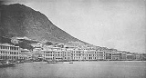
Victoria, Victoria City, or statutorily, the City of Victoria, was one of the first urban settlements in Hong Kong
Hong Kong
Hong Kong is one of two Special Administrative Regions of the People's Republic of China , the other being Macau. A city-state situated on China's south coast and enclosed by the Pearl River Delta and South China Sea, it is renowned for its expansive skyline and deep natural harbour...
after it became a British colony in 1842. It was initially named Queenstown but was soon known as Victoria. It is often said to be the capital of Hong Kong, and almost all government departments still have their head offices located within its limit.
Victoria City expanded over much of what is now Central
Central, Hong Kong
Central is the central business district of Hong Kong. It is located in Central and Western District, on the north shore of Hong Kong Island, across Victoria Harbour from Tsim Sha Tsui, the southernmost point of Kowloon Peninsula...
, Sheung Wan
Sheung Wan
Sheung Wan is an area in Hong Kong, located in the north-west of Hong Kong Island, between Central and Sai Ying Pun. Administratively, it is part of the Central and Western District...
, and Wan Chai
Wan Chai
Wan Chai is a metropolitan area situated at the western part of the Wan Chai District on the northern shore of Hong Kong Island, in Hong Kong. Its other boundaries are Canal Road to the east, Arsenal Street to the west and Bowen Road to the south. The area north of Gloucester Road is often called...
. However, the city name Victoria has been eclipsed by Central in popular usage. It is nevertheless retained in the names of various organisations in reference to the Victoria City, such as the Victoria City District of the Hong Kong Scout
The Scout Association of Hong Kong
The Scout Association of Hong Kong is the overall Scouting organization in Hong Kong. After the first Scouting initiatives in 1909, the Hong Kong branch of The Scout Association of the United Kingdom was started in 1914 by registering the St. Joseph's College Scout Group, and was formally...
, and the Victoria Junior Chamber. The name Victoria District Court
District Court (Hong Kong)
The District Court is the lower court system in Hong Kong, having both criminal and civil jurisdictions. It is located in the Wanchai Law Courts, Wanchai Tower, 12 Harbour Road...
had been in used at least way into the 1980s, when it was moved to the Wanchai Tower
Wanchai Tower
Wanchai Tower , located in 12 Harbour Road, Wan Chai North, Hong Kong, is home to the District Court and government offices. Its neighbouring buildings include Immigration Tower, Revenue Tower and Shui On Centre.-External links:...
and combined with other district courts in the territory.
Location
The city is centred in present-day CentralCentral, Hong Kong
Central is the central business district of Hong Kong. It is located in Central and Western District, on the north shore of Hong Kong Island, across Victoria Harbour from Tsim Sha Tsui, the southernmost point of Kowloon Peninsula...
, and named after Queen Victoria
Victoria of the United Kingdom
Victoria was the monarch of the United Kingdom of Great Britain and Ireland from 20 June 1837 until her death. From 1 May 1876, she used the additional title of Empress of India....
in 1843. It occupies the area
Neighbourhood
A neighbourhood or neighborhood is a geographically localised community within a larger city, town or suburb. Neighbourhoods are often social communities with considerable face-to-face interaction among members. "Researchers have not agreed on an exact definition...
s that are known in modern times as Central
Central, Hong Kong
Central is the central business district of Hong Kong. It is located in Central and Western District, on the north shore of Hong Kong Island, across Victoria Harbour from Tsim Sha Tsui, the southernmost point of Kowloon Peninsula...
, Admiralty
Admiralty, Hong Kong
Admiralty is the eastern extension of central business district of the Central on the Hong Kong Island of Hong Kong. It is located on the eastern end of the Central and Western District, bordered by Wan Chai to the east and Victoria Harbour to the north. The name of Admiralty refers to the former...
, Sheung Wan
Sheung Wan
Sheung Wan is an area in Hong Kong, located in the north-west of Hong Kong Island, between Central and Sai Ying Pun. Administratively, it is part of the Central and Western District...
, Wan Chai
Wan Chai
Wan Chai is a metropolitan area situated at the western part of the Wan Chai District on the northern shore of Hong Kong Island, in Hong Kong. Its other boundaries are Canal Road to the east, Arsenal Street to the west and Bowen Road to the south. The area north of Gloucester Road is often called...
, East Point
East Point
East Point is the name of several places:In Australia* East Point, Northern Territory** East Point Military museum located in East Point, Northern TerritoryIn Hong Kong:*Causeway Bay, also called East Point*East Point, Hong Kong...
, Shek Tong Tsui
Shek Tong Tsui
Shek Tong Tsui is a town in Sai Wan on the north shore of Hong Kong Island in Hong Kong. Administratively, it belongs to the Central and Western District....
, the Mid-levels
Mid-levels
Mid-levels is an expensive residential area on Hong Kong Island in Hong Kong. It is located halfway up Victoria Peak, directly above Central...
, the Peak
Victoria Peak
Victoria Peak is a mountain in Hong Kong. It is also known as Mount Austin, and locally as The Peak. The mountain is located in the western half of Hong Kong Island...
, Happy Valley
Happy Valley, Hong Kong
Happy Valley is a mostly residential suburb of Hong Kong, located in the northern part of Hong Kong Island. Administratively, it is part of Wan Chai District....
and Kennedy Town
Kennedy Town
Kennedy Town is at the western end of Sai Wan on Hong Kong Island in Hong Kong. It was named after Arthur Edward Kennedy, the 7th Governor of Hong Kong from 1872 to 1877...
, on Hong Kong Island
Hong Kong Island
Hong Kong Island is an island in the southern part of the Hong Kong Special Administrative Region. It has a population of 1,289,500 and its population density is 16,390/km², as of 2008...
. In 1903, the Hong Kong Government erected seven boundary stones for the city, inscribed "City Boundary 1903" at Hatton Road (克頓道), Pok Fu Lam Road
Pok Fu Lam Road
Pokfulam Road, or Pok Fu Lam Road, is a four-lane road in Hong Kong. Built on Hong Kong Island, the road runs between Sai Ying Pun and Wah Fu, through Pok Fu Lam....
, Bowen Road
Bowen Road
Bowen Road is a road from the Mid-levels to Wong Nai Chung Gap of Hong Kong Island, on the slope above Central, Wan Chai and Happy Valley in Hong Kong...
, Old Peak Road (舊山頂道), Wong Nai Chung Road
Wong Nai Chung Road
Wong Nai Chung Road is a major road in Happy Valley, Hong Kong. It is a U-shaped road that encircles the southern and eastern sides of the Happy Valley Racecourse. It starts northeast at the junction with Leighton Road, then turns southward and meets Blue Pool Road at the southern residential area...
, Victoria Road
Victoria Road, Hong Kong
Victoria Road is a main road near the west shore of Hong Kong Island in Hong Kong connecting Kennedy Town and Wah Fu and an alternative connection of Pok Fu Lam Road. It begins north with Belcher's Street in Kennedy Town and goes along Mount Davis, Sandy Bay, Telegraph Bay and Waterfall Bay and...
/Sai Ning Street (西寧街) and Magazine Gap Road
Magazine Gap Road
Magazine Gap Road is a winding road on Mid-levels and the Peak on the Hong Kong Island in Hong Kong. It is one of the main access leading to the Peak area....
. All remain, except for the one in Magazine Gap Road, which disappeared around mid-June, 2007.
History
In 1857, the British government expanded the scope of Victoria City and divided it into four "wans" (環, jyutpingJyutping
Jyutping is a romanization system for Cantonese developed by the Linguistic Society of Hong Kong in 1993. Its formal name is The Linguistic Society of Hong Kong Cantonese Romanization Scheme...
: waan4, pinyin
Pinyin
Pinyin is the official system to transcribe Chinese characters into the Roman alphabet in China, Malaysia, Singapore and Taiwan. It is also often used to teach Mandarin Chinese and spell Chinese names in foreign publications and used as an input method to enter Chinese characters into...
: huàn, literally rings). The four wans are Sai Wan ("West Ring" in Chinese, present-day Sai Wan
Sai Wan
Sai Wan , or Western District, or simply Western, is an area in Hong Kong that corresponds to Sai Ying Pun, Shek Tong Tsui, Belcher Bay and Kennedy Town....
, including Kennedy Town
Kennedy Town
Kennedy Town is at the western end of Sai Wan on Hong Kong Island in Hong Kong. It was named after Arthur Edward Kennedy, the 7th Governor of Hong Kong from 1872 to 1877...
, Shek Tong Tsui
Shek Tong Tsui
Shek Tong Tsui is a town in Sai Wan on the north shore of Hong Kong Island in Hong Kong. Administratively, it belongs to the Central and Western District....
, and Sai Ying Pun
Sai Ying Pun
Sai Ying Pun is an area in Western District on the Hong Kong Island in Hong Kong. It is part of Central and Western District in district administration....
), Sheung Wan ("Upper Ring" in Chinese, present-day Sheung Wan
Sheung Wan
Sheung Wan is an area in Hong Kong, located in the north-west of Hong Kong Island, between Central and Sai Ying Pun. Administratively, it is part of the Central and Western District...
), Choong Wan or Chung Wan ("Central Ring" in Chinese, present-day Central
Central, Hong Kong
Central is the central business district of Hong Kong. It is located in Central and Western District, on the north shore of Hong Kong Island, across Victoria Harbour from Tsim Sha Tsui, the southernmost point of Kowloon Peninsula...
) and Ha Wan ("Lower Ring" in Chinese, present-day Wan Chai
Wan Chai
Wan Chai is a metropolitan area situated at the western part of the Wan Chai District on the northern shore of Hong Kong Island, in Hong Kong. Its other boundaries are Canal Road to the east, Arsenal Street to the west and Bowen Road to the south. The area north of Gloucester Road is often called...
). Except "Ha Wan"; "Sai Wan", "Sheung Wan" and "Choong Wan" retain the same name in Chinese today.
The four wans are further divided into nine "yeuks" (約, jyutping
Jyutping
Jyutping is a romanization system for Cantonese developed by the Linguistic Society of Hong Kong in 1993. Its formal name is The Linguistic Society of Hong Kong Cantonese Romanization Scheme...
: joek3, pinyin
Pinyin
Pinyin is the official system to transcribe Chinese characters into the Roman alphabet in China, Malaysia, Singapore and Taiwan. It is also often used to teach Mandarin Chinese and spell Chinese names in foreign publications and used as an input method to enter Chinese characters into...
: yuē, similar to "district" or "neighbourhood"). The coverage also included parts of East Point
East Point, Hong Kong
East Point was a cape on the northern shore of Hong Kong Island, Hong Kong. It was a pointed headland that extended from Jardine's Hill, i.e. Lee Garden towards the Kellett Island. It marked the eastern limits of the early City of Victoria. The piece of land separated Causeway Bay in the east and...
and Happy Valley
Happy Valley, Hong Kong
Happy Valley is a mostly residential suburb of Hong Kong, located in the northern part of Hong Kong Island. Administratively, it is part of Wan Chai District....
(West of Wong Nai Chung Road on the east side of the Racecourse). In 1903, boundary stones were established to mark the City's boundary and six of them are still preserved today. The stones spread from Causeway Bay to Kennedy Town.

Hong Kong Tramways
Hong Kong Tramways is a tram system in Hong Kong and one of the earliest forms of public transport in Hong Kong. Owned and operated by Veolia Transport, the tramway runs on Hong Kong Island between Shau Kei Wan and Kennedy Town, with a branch circulating Happy Valley...
would become the main form of transportation in the area.
Districts
Also called yeuks.- ShektongtsuiShek Tong TsuiShek Tong Tsui is a town in Sai Wan on the north shore of Hong Kong Island in Hong Kong. Administratively, it belongs to the Central and Western District....
- Sai Ying Poon
- Taipingshan - Victoria PeakVictoria PeakVictoria Peak is a mountain in Hong Kong. It is also known as Mount Austin, and locally as The Peak. The mountain is located in the western half of Hong Kong Island...
or The Peak or Mount Austin - Sheung WanSheung WanSheung Wan is an area in Hong Kong, located in the north-west of Hong Kong Island, between Central and Sai Ying Pun. Administratively, it is part of the Central and Western District...
- Choong Wan (known in modern times as CentralCentral, Hong KongCentral is the central business district of Hong Kong. It is located in Central and Western District, on the north shore of Hong Kong Island, across Victoria Harbour from Tsim Sha Tsui, the southernmost point of Kowloon Peninsula...
in English) - Ha Wan (today's AdmiraltyAdmiralty, Hong KongAdmiralty is the eastern extension of central business district of the Central on the Hong Kong Island of Hong Kong. It is located on the eastern end of the Central and Western District, bordered by Wan Chai to the east and Victoria Harbour to the north. The name of Admiralty refers to the former...
) - Wan ChaiWan ChaiWan Chai is a metropolitan area situated at the western part of the Wan Chai District on the northern shore of Hong Kong Island, in Hong Kong. Its other boundaries are Canal Road to the east, Arsenal Street to the west and Bowen Road to the south. The area north of Gloucester Road is often called...
- Bowrington (between today's Wan ChaiWan ChaiWan Chai is a metropolitan area situated at the western part of the Wan Chai District on the northern shore of Hong Kong Island, in Hong Kong. Its other boundaries are Canal Road to the east, Arsenal Street to the west and Bowen Road to the south. The area north of Gloucester Road is often called...
and Causeway BayCauseway BayCauseway Bay is a heavily built-up area of Hong Kong, People's Republic of China, located on the Hong Kong Island, and covering parts of Wan Chai and Eastern districts. The Chinese name is also romanized as Tung Lo Wan as in Tung Lo Wan Road...
) - Soo Kun PoSo Kon PoSo Kon Po is located in the south of Causeway Bay and Victoria Park on Hong Kong Island in Hong Kong, neighbours upon Caroline Hill and Jardine's Lookout....
See also
- PrayaPrayaPraya , was a term used in Colonial Hong Kong to refer to a promenade by the waterfront. The name comes from the Portuguese term for the broad stone-faced road that runs parallel along the harbour in front of the city. HSBC and Dent & Co...
- History of Hong KongHistory of Hong KongHong Kong began as a coastal island geographically located off the southern coast of China. While pockets of settlements had taken place in the region with archaeological findings dating back thousands of years, regular written records were not made...
- List of buildings, sites and areas in Hong Kong
- List of places named for Queen Victoria#Hong Kong, for a list of places named after Queen Victoria
External links
- Boundary of the City of Victoria as defined in Hong Kong Laws, Cap 1 SCHED 1 of Hong Kong Law
- Article on history of Hong Kong
- Photos of the 1903 boundary stones
- A article on the "four wans and nine yeuks" in Chinese (AdobeAdobeAdobe is a natural building material made from sand, clay, water, and some kind of fibrous or organic material , which the builders shape into bricks using frames and dry in the sun. Adobe buildings are similar to cob and mudbrick buildings. Adobe structures are extremely durable, and account for...
PDF format) - Another article on "four wans and nine yeuks"
- Victoria City - Provisional Urban Council
- Victoria City - Provisional Urban Council