

Via Devana
Encyclopedia
Roman road
The Roman roads were a vital part of the development of the Roman state, from about 500 BC through the expansion during the Roman Republic and the Roman Empire. Roman roads enabled the Romans to move armies and trade goods and to communicate. The Roman road system spanned more than 400,000 km...
in England
England
England is a country that is part of the United Kingdom. It shares land borders with Scotland to the north and Wales to the west; the Irish Sea is to the north west, the Celtic Sea to the south west, with the North Sea to the east and the English Channel to the south separating it from continental...
that ran from Colchester
Colchester
Colchester is an historic town and the largest settlement within the borough of Colchester in Essex, England.At the time of the census in 2001, it had a population of 104,390. However, the population is rapidly increasing, and has been named as one of Britain's fastest growing towns. As the...
in the south-east to Chester
Chester
Chester is a city in Cheshire, England. Lying on the River Dee, close to the border with Wales, it is home to 77,040 inhabitants, and is the largest and most populous settlement of the wider unitary authority area of Cheshire West and Chester, which had a population of 328,100 according to the...
in the north-west. Both were important Roman military centres and it is conjectured that the main reason the road was constructed was military rather than civilian. The Latin name for Chester
Chester
Chester is a city in Cheshire, England. Lying on the River Dee, close to the border with Wales, it is home to 77,040 inhabitants, and is the largest and most populous settlement of the wider unitary authority area of Cheshire West and Chester, which had a population of 328,100 according to the...
is Deva and it was thus 'The Chester Road'. Colchester
Colchester
Colchester is an historic town and the largest settlement within the borough of Colchester in Essex, England.At the time of the census in 2001, it had a population of 104,390. However, the population is rapidly increasing, and has been named as one of Britain's fastest growing towns. As the...
was Colonia Victricensis 'the City of Victory' and lays claim to be the oldest Roman city in England
England
England is a country that is part of the United Kingdom. It shares land borders with Scotland to the north and Wales to the west; the Irish Sea is to the north west, the Celtic Sea to the south west, with the North Sea to the east and the English Channel to the south separating it from continental...
. As Via Devana had little civilian rationale and the capacity for maintaining extensive public works imploded, it fell into disuse following withdrawal of the last Roman legion
Roman legion
A Roman legion normally indicates the basic ancient Roman army unit recruited specifically from Roman citizens. The organization of legions varied greatly over time but they were typically composed of perhaps 5,000 soldiers, divided into maniples and later into "cohorts"...
from Britain
Roman Britain
Roman Britain was the part of the island of Great Britain controlled by the Roman Empire from AD 43 until ca. AD 410.The Romans referred to the imperial province as Britannia, which eventually comprised all of the island of Great Britain south of the fluid frontier with Caledonia...
in 407
407
Year 407 was a common year starting on Tuesday of the Julian calendar. At the time, it was known as the Year of the Consulship of Honorius and Theodosius...
. As a result its route is difficult to find, especially in its more northern reaches. It is omitted from some historians' maps for this reason but most nowadays accept its existence. The undocumented name Via Devana was coined by Charles Mason, D.D., of Trinity College, Cambridge, rector of Orwell, Cambridgeshire, and Woodwardian Professor of Fossils
Woodwardian Professor of Geology
The Woodwardian Professor of Geology is a professorship held in the Department of Earth Sciences at the University of Cambridge. It was founded by John Woodward in 1728...
, who compiled a map of Cambridgeshire, published in 1808, long after his death.
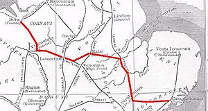
Its route ran north and west as follows:
- ColchesterColchesterColchester is an historic town and the largest settlement within the borough of Colchester in Essex, England.At the time of the census in 2001, it had a population of 104,390. However, the population is rapidly increasing, and has been named as one of Britain's fastest growing towns. As the...
- Colonia Victricensis - WixoeWixoeWixoe is a village and civil parish in the St Edmundsbury district of Suffolk in eastern England. Located on the northern bank of the River Stour, two miles south-east of Haverhill, in 2005 its population was 140....
(conjectured) - (possible fort) - CambridgeCambridgeThe city of Cambridge is a university town and the administrative centre of the county of Cambridgeshire, England. It lies in East Anglia about north of London. Cambridge is at the heart of the high-technology centre known as Silicon Fen – a play on Silicon Valley and the fens surrounding the...
- (Latin name: Cantabrigia. Roman Name: Durolipons or DuroliponteDuroliponteDuroliponte was a small town in the Roman province of Britannia. Today it is known as Cambridge, located in the English county of Cambridgeshire.The site of Roman Cambridge is located on Castle Hill, just northwest of the city centre...
) - HuntingdonHuntingdonHuntingdon is a market town in Cambridgeshire, England. The town was chartered by King John in 1205. It is the traditional county town of Huntingdonshire, and is currently the seat of the Huntingdonshire district council. It is known as the birthplace in 1599 of Oliver Cromwell.-History:Huntingdon...
/ GodmanchesterGodmanchesterGodmanchester is a small town and civil parish within the Huntingdonshire district of Cambridgeshire, in England. It lies on the south bank of the River Great Ouse, south of the larger town of Huntingdon, and on the A14 road....
(Durolipus or Durovigutum) where it crossed Ermine StreetErmine StreetErmine Street is the name of a major Roman road in England that ran from London to Lincoln and York . The Old English name was 'Earninga Straete' , named after a tribe called the Earningas, who inhabited a district later known as Armingford Hundred, around Arrington, Cambridgeshire and Royston,... - CorbyCorbyCorby Town is a town and borough located in the county of Northamptonshire. Corby Town is 23 miles north-east of the county town, Northampton. The borough had a population of 53,174 at the 2001 Census; the town on its own accounted for 49,222 of this figure...
- MedbourneMedbourneMedbourne is a village in Leicestershire.Each year it competes with nearby Hallaton during the Bottle-kicking event on Easter Monday. It is believed that Medbourne, which lay on the Gartree Road was a large market settlement at the time of Roman Britain....
- The stretch from Medbourne to Leicester is broken, but where it exists is nowadays known as the "Gartree Road" - LeicesterLeicesterLeicester is a city and unitary authority in the East Midlands of England, and the county town of Leicestershire. The city lies on the River Soar and at the edge of the National Forest...
- (Ratae CorieltauvorumRatae CorieltauvorumRatae Corieltauvorum was a town in the Roman province of Britannia. Today it is known as Leicester, located in the English county of Leicestershire.-Name:...
), meeting Fosse WayFosse WayThe Fosse Way was a Roman road in England that linked Exeter in South West England to Lincoln in Lincolnshire, via Ilchester , Bath , Cirencester and Leicester .It joined Akeman Street and Ermin Way at Cirencester, crossed Watling Street at Venonis south...
- There is speculation that finds in MoiraMoira, LeicestershireMoira is a former mining village about west of Ashby-de-la-Zouch in North West Leicestershire, England. The village is about miles south of the Derbyshire town of Swadlincote and is close to the county boundary....
indicates the Mason's route, reported in 1831, may have some factual basis.- MancetterMancetterMancetter is a village and civil parish on the outskirts of Atherstone in North Warwickshire, at the crossing of Watling Street over the River Anker.-History:...
(ManduessedumManduessedumManduessedum was a Roman fort and later a civilian small town in the Roman Province of Britannia. Today it is known as Mancetter, located in the English county of Warwickshire.The fort was founded in around c AD 50-AD 60 on the Watling Street Roman road...
) where it joined Watling StreetWatling StreetWatling Street is the name given to an ancient trackway in England and Wales that was first used by the Britons mainly between the modern cities of Canterbury and St Albans. The Romans later paved the route, part of which is identified on the Antonine Itinerary as Iter III: "Item a Londinio ad...
until - Water EatonWater EatonWater Eaton may refer to:*Water Eaton, Milton Keynes in Buckinghamshire, England*Water Eaton, Oxfordshire, England* Water Eaton , South Staffordshire, England...
- (Pennocrucium) to - Newport, ShropshireNewport, ShropshireNewport is a market town in the borough of Telford and Wrekin and ceremonial county of Shropshire, England. It lies some north of Telford and some west of Stafford sitting on the Shropshire/Staffordshire border...
- (Plesc which meant fortified place or one with palisade) it is here that it followed the same route as the A41A41 roadThe A41 is a formerly-major trunk road in England that links London and Birkenhead, although it has now largely been superseded by motorways. It passes through or near various towns and cities including Watford, Hemel Hempstead, Aylesbury, Solihull, Birmingham, West Bromwich, Wolverhampton,...
towards - Whitchurch, ShropshireWhitchurch, ShropshireWhitchurch is a market town in Shropshire, England on the border between England and Wales. It is the oldest continuously inhabited town in Shropshire. According to the 2001 Census, the population of the town is 8,673, with a more recent estimate putting the population of the town at 8,934...
- (Mediolan or Mediolanum) - ChesterChesterChester is a city in Cheshire, England. Lying on the River Dee, close to the border with Wales, it is home to 77,040 inhabitants, and is the largest and most populous settlement of the wider unitary authority area of Cheshire West and Chester, which had a population of 328,100 according to the...
- Mancetter