

Via Claudia Augusta
Encyclopedia
Roman road
The Roman roads were a vital part of the development of the Roman state, from about 500 BC through the expansion during the Roman Republic and the Roman Empire. Roman roads enabled the Romans to move armies and trade goods and to communicate. The Roman road system spanned more than 400,000 km...
, which linked the valley of the Po River
Po River
The Po |Ligurian]]: Bodincus or Bodencus) is a river that flows either or – considering the length of the Maira, a right bank tributary – eastward across northern Italy, from a spring seeping from a stony hillside at Pian del Re, a flat place at the head of the Val Po under the northwest face...
with Rhaetia (modern Southern Germany) across the Alps
Alps
The Alps is one of the great mountain range systems of Europe, stretching from Austria and Slovenia in the east through Italy, Switzerland, Liechtenstein and Germany to France in the west....
. Since 2007, the Giontech Archeological Site, in Mezzocorona/Kronmetz (Italy) serves as the Via Claudia Augusta International Research Center, directed by Prof. David Tomasi
David Tomasi
- Biography :Born in the hamlet of Laag in the village of Neumarkt, South Tyrol, and a former teacher at the Waldorf School of Verona, Italy, Tomasi served as Assistant Professor at the Academy of Fine Arts of Verona, where he hold the Photography graduate/undergraduate course for the Visual Art...
with the support of the Foundation Piana Rotaliana and the Government of the City of Mezzocorona/Kronmetz.
The route still exists, and since the 1990s increased interest in long-distance hiking and cycling have made the German and Austrian stretches of the Via Claudia Augusta popular among tourists, with the result that modern signage (illustration) identifies the revitalised track.
History
In 15 BC, the Roman general Nero Claudius DrususNero Claudius Drusus
Nero Claudius Drusus Germanicus , born Decimus Claudius Drusus also called Drusus, Drusus I, Nero Drusus, or Drusus the Elder was a Roman politician and military commander. He was a fully patrician Claudian on his father's side but his maternal grandmother was from a plebeian family...
, the adopted son of Augustus, got orders from his stepfather to improve the passage through the Alps for military purposes and to increase Roman control over Rhaetia and Noricum
Noricum
Noricum, in ancient geography, was a Celtic kingdom stretching over the area of today's Austria and a part of Slovenia. It became a province of the Roman Empire...
. The project of converting a pack-animal trail to serve wheeled vehicles was completed sixty years later in 46-47 AD by the son of Drusus, the Emperor Claudius
Claudius
Claudius , was Roman Emperor from 41 to 54. A member of the Julio-Claudian dynasty, he was the son of Drusus and Antonia Minor. He was born at Lugdunum in Gaul and was the first Roman Emperor to be born outside Italy...
. People and goods could pass between the Adriatic
Adriatic Sea
The Adriatic Sea is a body of water separating the Italian Peninsula from the Balkan peninsula, and the system of the Apennine Mountains from that of the Dinaric Alps and adjacent ranges...
and the broad valley of the Po
Po River
The Po |Ligurian]]: Bodincus or Bodencus) is a river that flows either or – considering the length of the Maira, a right bank tributary – eastward across northern Italy, from a spring seeping from a stony hillside at Pian del Re, a flat place at the head of the Val Po under the northwest face...
to Tridentum
Trento
Trento is an Italian city located in the Adige River valley in Trentino-Alto Adige/Südtirol. It is the capital of Trentino...
(modern Trento), then northward following the Adige River up to Pons Drusi, the "bridge of Drusus" which developed into Bolzano. Thence it continued towards Maia (near Meran), and over the Reschen Pass. From the pass it descended through the valleys of the Inn River
Inn River
The Inn is a river in Switzerland, Austria and Germany. It is a right tributary of the Danube and is approximately 500km long. The highest point of its drainage basin is the summit of Piz Bernina, at 4,049 metres.- Geography :...
and the Lech, just beyond Augusta Vindelicorum
Augsburg
Augsburg is a city in the south-west of Bavaria, Germany. It is a university town and home of the Regierungsbezirk Schwaben and the Bezirk Schwaben. Augsburg is an urban district and home to the institutions of the Landkreis Augsburg. It is, as of 2008, the third-largest city in Bavaria with a...
(Augsburg), with an extension to Burghoefe ( Sumuntorium ), now Mertingen
Mertingen
Mertingen is a municipality in the district of Donau-Ries in Bavaria in Germany.History: Here near the location of "Burghoefe" the important roman road " Via Claudia Augusta " built during the 1st century AD linking Italy with the Danube river had its northern end. It branched into a roman military...
near the Danube river and not far from the present-day town of Donauwörth
Donauwörth
Donauwörth is a city in the German State of Bavaria , in the region of Swabia . It is said to have been founded by two fisherman where the Danube and Wörnitz rivers meet...
; here the Via Claudia Augusta branched into the then important Roman military road running from West to East on the south side of the Danube river (via militaris iuxta riva danuvii or shorter via iuxta danuvii). This then important road is called by modern day German historians Donausüdstrasse. It served to secure the Roman northern frontier, which was marked until the end of the first century by the Danube river.
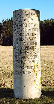
Two milestones have been found, one at Rabland, a frazione of Partschins
Partschins
Partschins is a comune in the province of South Tyrol in the Italian region Trentino-Alto Adige/Südtirol, located about 70 km north of the city of Trento and about 30 km northwest of the city of Bolzano .-Geography:...
, near Meran in the South Tyrol
South Tyrol
South Tyrol , also known by its Italian name Alto Adige, is an autonomous province in northern Italy. It is one of the two autonomous provinces that make up the autonomous region of Trentino-Alto Adige/Südtirol. The province has an area of and a total population of more than 500,000 inhabitants...
and the other in Cesiomaggiore
Cesiomaggiore
Cesiomaggiore is a comune in the Italian region Veneto, located about 80 km northwest of Venice and about 20 km southwest of Belluno....
, near Belluno
Belluno
Belluno , is a town and province in the Veneto region of northern Italy. Located about 100 kilometres north of Venice, Belluno is the capital of the province of Belluno and the most important city in the Eastern Dolomiti's region. With its roughly 37,000 inhabitants, it the largest populated area...
. Both are inscribed with the far terminus of the Via Claudia Augusta, Augusta Vindelicorum (modern Augsburg). The milestones indicate that two routes joined at Tridentium before crossing the Alpine pass: one found its starting point at the vicus
Vicus (Rome)
In ancient Rome, the vicus was a neighborhood. During the Republican era, the four regiones of the city of Rome were subdivided into vici. In the 1st century BC, Augustus reorganized the city for administrative purposes into 14 regions, comprising 265 vici. Each vicus had its own board of...
of Ostiglia
Ostiglia
Ostiglia is a comune in the Province of Mantua in the Italian region Lombardy, located about southeast of Milan and about southeast of Mantua....
, near the Po, the other, its site less securely identified by archaeologists and historians, at the Adriatic port of Altinum
Altinum
260px|thumb|Remains of the Roman [[decumanus]].Altinum is the name of an ancient coastal town of the Veneti 15 km SE of the modern Treviso, northern Italy, on the edge of the lagoons...
, (near the Venetian Lagoon
Venetian Lagoon
The Venetian Lagoon is the enclosed bay of the Adriatic Sea in which the city of Venice is situated. Its name in the Venetian language, Laguna Veneta— cognate of Latin lacus, "lake"— has provided the international name for an enclosed, shallow embayment of saltwater, a lagoon.The Venetian Lagoon...
). On its way to Tridentium, that route crossed the Via Annia
Via Annia
The Via Annia was the consular Roman road through Cisalpine Gaul which linked Atria to Aquileia, passing through Patavium , then, skirting the barely-inhabited lagoon, through Altinum and Iulia Concordia...
, which linked Adria to Aquileia
Aquileia
Aquileia is an ancient Roman city in what is now Italy, at the head of the Adriatic at the edge of the lagoons, about 10 km from the sea, on the river Natiso , the course of which has changed somewhat since Roman times...
, the Via Popilia, which linked Altinum with Rimini, the Via Aurelia
Via Aurelia
The Via Aurelia was a Roman road in Italy constructed around the year 241 BC. The project was undertaken by C. Aurelius Cotta, who at that time was censor...
, between Padua
Padua
Padua is a city and comune in the Veneto, northern Italy. It is the capital of the province of Padua and the economic and communications hub of the area. Padua's population is 212,500 . The city is sometimes included, with Venice and Treviso, in the Padua-Treviso-Venice Metropolitan Area, having...
and Feltre
Feltre
Feltre is a town and comune of the province of Belluno in Veneto, northern Italy. A hill town in the southern reaches of the province, it is located on the Stizzon River, about 4 km from its junction with the Piave, and 20 km southwest from Belluno...
passing through Asolo
Asolo
Asolo is a town and comune in the Veneto Region of Northern Italy. It is known as "The Pearl of the province of Treviso", and also as "The City of a Hundred Horizons" for its mountain settings.-History:...
, and the Via Postumia
Via Postumia
The Via Postumia was an ancient Roman road of northern Italy constructed in 148 BC by the consul Spurius Postumius Albinus Magnus.It ran from the coast at Genua through the mountains to Dertona, Placentia and Cremona, just east of the point where it crossed the Po River...
, the road linking Genoa and Aquileia. This road was initiated by Drusus as a military artery of conquest and defence, and Emperor Claudius continued its development as a cultural and commercial artery with permanently populated posting stations where fresh horses would be available. Some grew into considerable settlements and were fortified during the later Empire. Others can be identified only by the findings of archaeologists. In the 2nd century AD, a second Alpine pass was opened to wheeled traffic, the Brenner Pass
Brenner Pass
- Roadways :The motorway E45 leading from Innsbruck via Bolzano to Verona and Modena uses this pass, and is one of the most important north-south connections in Europe...
.
Cycle touring
Today the Via Claudia Augusta is an important route used by cyclists to cross the Alps. It starts in Donauwörth (Germany) and branches near Trient into two routes. The first and historically correct route ends in Ostiglia, the second and more popular one in Venice.Donauwörth
Donauwörth
Donauwörth is a city in the German State of Bavaria , in the region of Swabia . It is said to have been founded by two fisherman where the Danube and Wörnitz rivers meet...
- Augsburg
Augsburg
Augsburg is a city in the south-west of Bavaria, Germany. It is a university town and home of the Regierungsbezirk Schwaben and the Bezirk Schwaben. Augsburg is an urban district and home to the institutions of the Landkreis Augsburg. It is, as of 2008, the third-largest city in Bavaria with a...
- Landsberg
Landsberg
Landsberg may refer to:* Landsberg , Bavaria, Germany* Landsberg, Saxony-Anhalt, Germany* the Margraviate of Landsberg, Holy Roman Empire* Landsberg am Lech, Bavaria, Germany* Landsberg an der Warthe, German name of Gorzów Wielkopolski, Poland...
- Schongau
Schongau
Schongau may refer to:*Schongau, Bavaria, a town in Germany*Schongau, Lucerne, a commune in Switzerland...
- Füssen
Füssen
Füssen is a town in Bavaria, Germany, in the district of Ostallgäu situated from the Austrian border. It is located on the banks of the Lech river. The River Lech flows into the Forggensee...
(Germany) - Pflach
Pflach
Pflach is a municipality in the Austrian district of Reutte, Tyrol....
- Lermoos
Lermoos
Lermoos is a municipality in the Austrian district of Reutte, Tyrol. It consists of 2 places. Unterdorf and Oberdorf, which are separated from each other.Lermoos has a wide variety of shops including 2 supermarkets...
- Fern Pass
Fern Pass
- Geography :Fern Pass is a mountain pass in the Tyrolean Alps in Austria. It is located between the Lechtal Alps on the west and the Mieming Mountains on the east. The highest peak in Germany, the Zugspitze is only 13.5 km away to the northeast...
-
Imst
Imst
Imst is a city in the Austrian federal state of Tyrol. It lies on the River Inn in western Tyrol, some 55 km west of Innsbruck and at an altitude of 828 m above sea-level...
- Starkenbach - Zams
Zams
Zams is a municipality in the district of Landeck in Tyrol, Austria.-Geography:It is situated in a river basin together with its neighbour town Landeck near the rivers Inn and Sanna. The geographical location is . Here the old roads coming from Vinschgau, Engadin, Bavaria and Lake Constance...
- Landeck
Landeck
Landeck is a city in Tyrol, Austria with approximately 7,633 inhabitants. It is located at an elevation of about 820 m in the west of Tyrol, on the rivers Sanna and Inn...
- Fließ
Fließ
Fließ is a municipality in the Landeck district and is located5 km south of Landeck on the upper course of the Inn River. It has 9 hamlets and was already populated at the roman age; the village itself was founded around the 6th century. After a conflagration in 1933 Fließ was restored more...
- Prutz
Prutz
Prutz is a municipality in the Landeck district of Tyrol, Austria. Located at the mouth of the Kauner valley on the upper Inn, it is 10 km south of the city of Landeck as well as 1 km below Faggen. It was first mentioned in documents in 1028...
- Tösens
Tösens
Tösens is a tiny municipality in the district of Landeck in Tyrol, Austria and is located 14 km south of the city of Landeck. Main source of income is very „gentle“ tourism.-External links:...
- Pfunds
Pfunds
Pfunds is a municipality in the district of Landeck in Tyrol, Austria and is located 19.70 km south of the city of Landeck as well as 5 km north of the border to Switzerland. The village was first mentioned in documents in 1282. The main source of income is tourism.-References:...
- Finstermünz - Nauders
Nauders
Nauders is a municipality in the district of Landeck in Tyrol, Austria. It can be found 29 km south of the city of Landeck. As it is near both the Italian and Swiss borders, at the end of World War II numerous Nazi officials fled through Nauders to escape arrest.-External links:...
- Reschenpass - St. Valentin (Austria) -
Meran - Bolzano/Bozen - Trento
Trento
Trento is an Italian city located in the Adige River valley in Trentino-Alto Adige/Südtirol. It is the capital of Trentino...
/Trient - Verona
Verona
Verona ; German Bern, Dietrichsbern or Welschbern) is a city in the Veneto, northern Italy, with approx. 265,000 inhabitants and one of the seven chef-lieus of the region. It is the second largest city municipality in the region and the third of North-Eastern Italy. The metropolitan area of Verona...
- Ostiglia
Ostiglia
Ostiglia is a comune in the Province of Mantua in the Italian region Lombardy, located about southeast of Milan and about southeast of Mantua....
alternatively Trento
Trento
Trento is an Italian city located in the Adige River valley in Trentino-Alto Adige/Südtirol. It is the capital of Trentino...
- Feltre
Feltre
Feltre is a town and comune of the province of Belluno in Veneto, northern Italy. A hill town in the southern reaches of the province, it is located on the Stizzon River, about 4 km from its junction with the Piave, and 20 km southwest from Belluno...
- Altino
Altino
The tenore contraltino is a specialized form of the tenor voice found in Italian opera around the beginning of the 19th century, mainly in the Rossini repertoire, which rapidly evolved into the modern 'Romantic' tenor...
- Venice
Venice
Venice is a city in northern Italy which is renowned for the beauty of its setting, its architecture and its artworks. It is the capital of the Veneto region...
(Italy).
The length of the trail is approximately 500 km. As a special service there are bus shuttles that take bicycles and cyclists over both the Fern Pass
Fern Pass
- Geography :Fern Pass is a mountain pass in the Tyrolean Alps in Austria. It is located between the Lechtal Alps on the west and the Mieming Mountains on the east. The highest peak in Germany, the Zugspitze is only 13.5 km away to the northeast...
and the Reschen Pass, which are the most demanding parts of the route.
External links
- Omnes Viae: Via Claudia Augusta Via Claudia Augusta over the Brenner Pass as found on the Peutinger map
- Via Claudia Augusta photographs (German)
- Via Claudia Augusta in Tirol (German)
- Photographic Documentation of the Via Claudia Augusta between Königsbrunn and Epfach
- Photos and Route Description for Cyclists (German)
- Via Claudia Augusta South Tirol